March 13 , 2026.
La Réunion Island , Piton de la Fournaise :
Press release from the Paris Institute of Earth Physics / Piton de la Fournaise Volcanological Observatory, March 13, 2026 – 9:00 AM local time – 5:00 AM UTC.
Eruption in progress
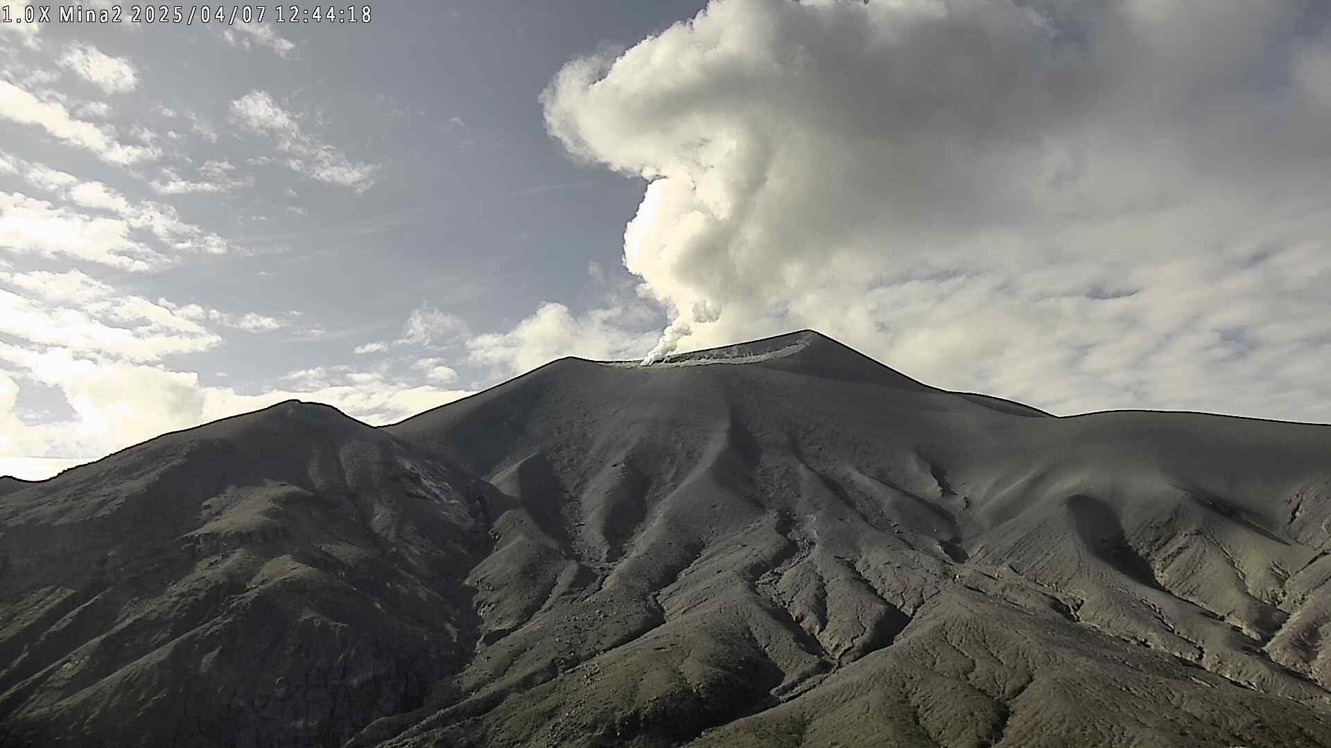
The eruption that began on February 13, 2026, shortly after 10:00 AM (local time) at Piton de la Fournaise continues.
Only one eruptive site remains active on the south-southeast flank of the volcano, visible from Piton de Bert. The eruptive cone is now well-formed and continues to close progressively. Few ejecta now exceed the height of the cone.
With the lateral closure of the cone, significant lava tube activity is now established. Since March 3, lava flows have again been visible in the Grandes Pentes area with a new flow arm.
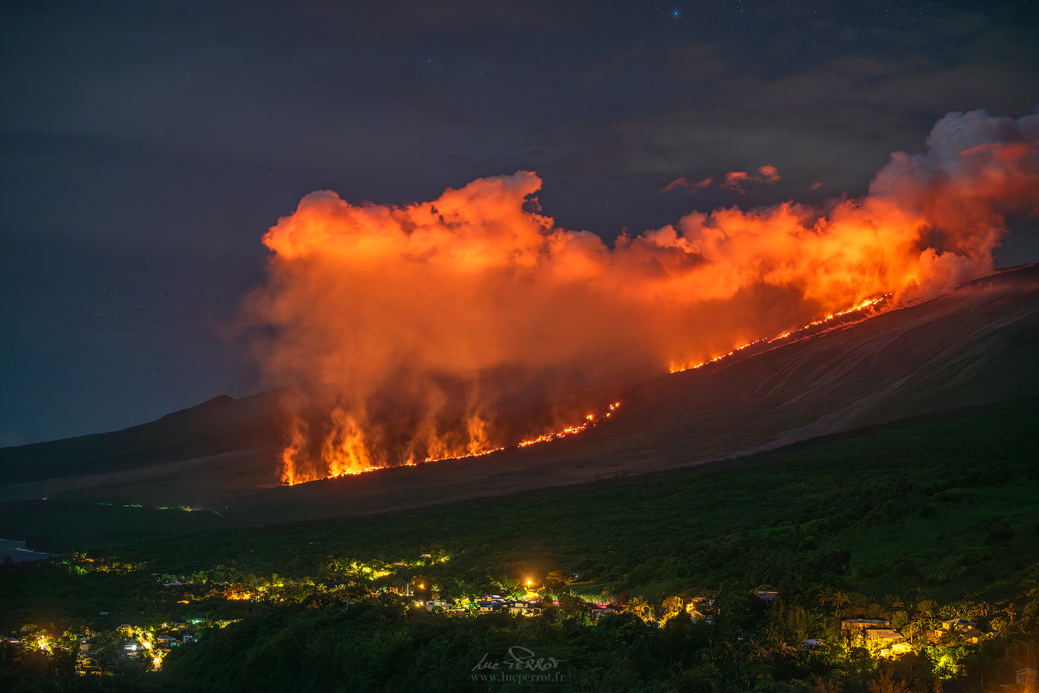
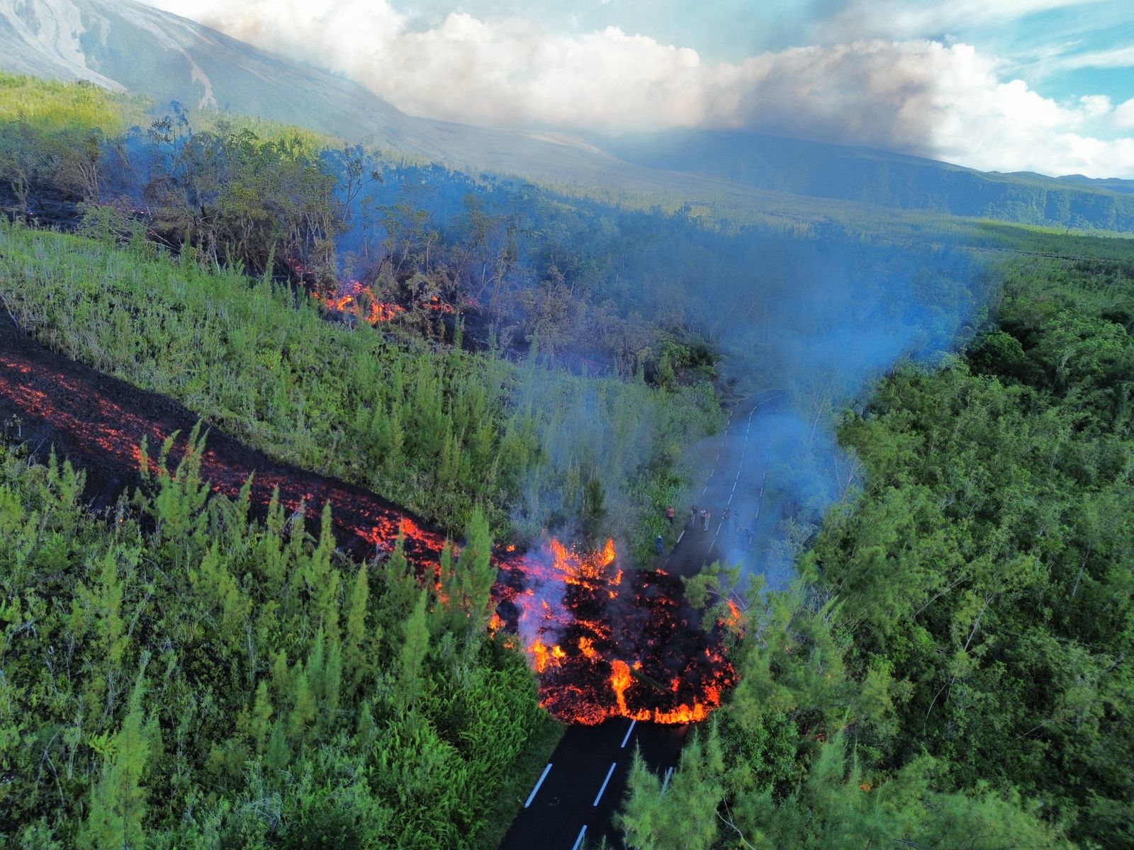
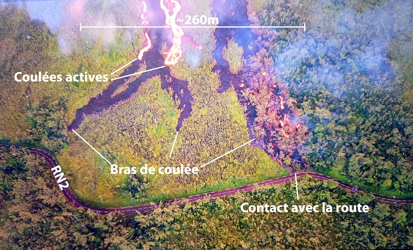
Since the morning of March 12, monitoring of the lava flow has been carried out by teams from the Piton de la Fournaise Volcanological Observatory in the Grand Brulé area. The lava field erupting from the eruptive site still forms two main arms. The front of the northern arm remains stationary approximately 2.6 km from National Route 2 (RN2), at an altitude of about 660 m.
The southern arm continued its advance between March 12 and 13, with highly variable speeds due in particular to the topography and vegetation encountered along its path, which can locally slow or channel the lava flow.
Thus, after propagating at speeds between 2 and 70 meters per hour, the flow front stabilized yesterday evening at 6:00 PM (local time) approximately 120 m from RN2. The mudflow resumed its advance around 11:40 PM and reached the road this morning at 5:53 AM before stalling again.
Meanwhile, several mudflow branches developed further upstream and advanced towards the RN2 highway overnight. These branches extend over a total width of approximately 260 meters parallel to the axis of the RN2. At 8:00 AM local time, one of these mudflow branches finally crossed the RN2.
Since this crossing, the mudflow has continued its advance towards the coastline. At the time of writing this bulletin, the mudflow front is estimated to be approximately 700 meters from the ocean. A monitoring team from the OVPF (Volcanological Observatory of Piton de la Fournaise) will be present again today to track the mudflow’s progress.
As in previous days, seismic activity remains low.
The inflation of the volcano, visible particularly on the summit GNSS stations and at the base of the terminal cone, continues. Since the end of February, the baselines crossing the summit have been registering an increase in distance, indicating a progressive re-expansion of the volcano. This inflation indicates a repressurization of the magma supply system, possibly linked to magma recharge from the shallow reservoir.
Following the abrupt drop in tremor on March 11 (an indicator of lava and gas emissions at the surface), tremor remains at a relatively stable level. Surface flow rates, estimated from satellite data via the HOTVOLC platform (OPGC – Université Clermont Auvergne), have indicated values of less than 7 m³/s over the past 24 hours.
It should be noted that depending on cloud cover, these estimates can vary significantly and become zero in the event of total cloud cover. Current activity in the lava tunnel also tends to minimize the flow rates observed by satellite method.
Satellite estimates of sulfur dioxide (SO₂) flux show a peak in degassing at the start of the eruption on February 13, followed by a gradual decrease and lower but persistent values over the past few weeks, broadly consistent with measurements from the DOAS NOVAC network. The total mass of SO₂ emitted since the start of the eruption is estimated at over 35 kt.
Alert Level 2.2
Source : OVPF/IPGP.
Photos : Luc PERROT Photographies , Le quotidien de la Réunion , OVPF.
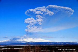
Kamchatka , Sheveluch :
KVERT VOLCANIC ACTIVITY NOTICE (VAN)
Issued: March 12 ,20260312/0010Z
Volcano: Sheveluch (CAVW #300270)
Current aviation colour code: ORANGE
Previous aviation colour code: orange
Source: KVERT
Notice Number: 2026-25
Volcano Location: N 56 deg 38 min E 161 deg 19 min
Area: Kamchatka, Russia
Summit Elevation: 3283 m (10768.24 ft), the dome elevation ~2500 m (8200 ft)
Volcanic Activity Summary:
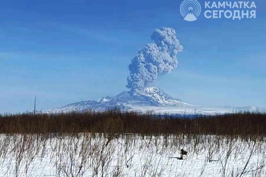
An explosive-extrusive eruption of the volcano continues, accompanied by powerful gas-steam activity. Explosions sent ash up to 8 km a.s.l., and ash cloud move for 10 km to the east of the volcano. Ongoing activity could affect international and low-flying aircraft.
Volcanic cloud height:
8000 m (26240 ft) AMSL Time and method of ash plume/cloud height determination: 20260311/2352Z – Video data
Other volcanic cloud information:
Distance of ash plume/cloud of the volcano: 10 km (6 mi)
Direction of drift of ash plume/cloud of the volcano: E
Time and method of ash plume/cloud determination: 20260311/2352Z – Visual data
Start time of explosion and how determined: 20260311/2352Z – Visual data
Duration of explosion: ~ 15 min
Source : Kvert.
Photo: ИА Камчатка
New Zealand , White Island :
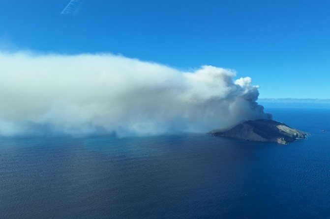
Weak ash plume observed from Whakaari/White Island. Volcanic Alert Level raised to 3 and Aviation Colour Code changed to Orange.
Published: Thu Mar 12 2026 3:45 PM
This morning, photos from near Whakaari/White Island show some ash being expelled in the low-level plume. The Volcanic Alert Level is raised to 3 and the Aviation Colour Code changed to Orange.
Since late last week a steam and gas plume has been visible from the Bay of Plenty coast. This morning, pilot reports indicate ash is also being emitted in a weak eruption from the main vent area. The images shared with us show ashfall inside the main crater floor but no major changes to the vent or any eruption of rocks. Small amounts of volcanic sulphur dioxide gas are being detected in the atmosphere by the TropOMI satellite sensor.
These observations point to a slight increase in the activity to a non-explosive weak eruption. With the current wind direction and strength, and forecast for the next few days, minute traces of ash could reach the Bay of Plenty coast but is ashfall is unlikely to be noticeable at ground level. The intensity of volcanic activity at Whakaari could escalate with little or no warning, mostly affecting the crater floor area and immediate vicinity of the island, and still with a low likelihood of ashfall affecting on the mainland. Scientists will make a gas-measuring and observation flight as soon as weather conditions allow.
The forecast weather conditions mean GeoNet camera images and satellite imagery will be unclear, and near-island observations are unlikely to occur. We also note our current lack of real-time monitoring data from the island. Consequently, Whakaari/White Island will remain at Volcanic Alert Level 3 and Aviation Colour Code Orange until better observations are possible in the next few days.
Earth Sciences New Zealand’s Volcano Monitoring Group and National Geohazards Monitoring Centre will continue to closely monitor Whakaari/White Island for any changes in activity. Without sensors on the island, our monitoring continues to rely on remote cameras, satellite imagery, and periodic observation and gas flights to monitor Whakaari/White Island. We will provide further updates when information becomes available.
Source : Geonet.
Photo : geonet / A Mazot ( archive)
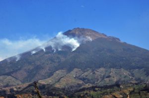
Colombia , Puracé – Los Coconucos volcanic chain :
Popayán, March 10, 2026, 3:00 PM
Regarding the monitoring of activity at the Puracé volcano – Los Coconucos volcanic chain – the Colombian Geological Survey (SGC), an agency under the Ministry of Mines and Energy, reports the following:
During the week of March 3-9, 2026, the predominant activity continued to consist of earthquakes associated with fluid movements within the volcanic edifice, of the long-period (LP) and tremor (TR) type. These earthquakes were located below the crater of the Puracé volcano, at depths of less than 1 km, and were linked to circulation processes and the release of volcanic gases into the atmosphere. These gases dispersed according to the wind direction, reaching a maximum altitude of 791 m above the summit of the volcano.
Fracture seismicity remained stable compared to previous weeks, both in terms of frequency and seismic energy released, and was primarily localized between the Puracé and Piocollo volcanoes, at depths of 1 to 3 km. Sulfur dioxide (SO₂) emissions continued, and gas emissions persisted through the crater fissures of the Curiquinga and Piocollo volcanoes. No ash emissions were observed during this period. Satellite observations indicate that the energy of the thermal anomaly in the Puracé volcano crater persists. Furthermore, the slow deformation process continues between the Puracé, Piocollo, and Curiquinga volcanoes, as demonstrated by the eruptive episode of Curiquinga on January 20, 2025.
In conclusion, the observed variations in the Los Coconucos volcanic chain (Puracé volcano) indicate that the system continues to evolve and that ash emissions and fallout could continue, depending on the prevailing wind direction. The public is advised to refrain from ascending to the upper reaches of the volcanic chain and to remain attentive to official bulletins from the Colombian Geological Survey (SGC).
The alert level for volcanic activity remains yellow: active volcano showing changes in monitored parameters and other manifestations.
Source et photo : SGC.
Chile , Laguna del Maule :
SPECIAL REPORT ON VOLCANIC ACTIVITY, March 6, 2026
The Argentine Geological and Mining Service (SEGEMAR), through its Argentine Volcanic Monitoring Observatory (OAVV), reports that today, Friday, March 6, 2026, at 6:39 a.m. local time (3:39 a.m. UTC), the volcanic monitoring stations installed near the Laguna del Maule volcanic complex recorded a volcano-tectonic (VT) seismic event associated with rock fracturing within the volcanic system.
Event Information
Origin Time: 6:39 a.m. local time (3:39 a.m. UTC)
Latitude: -36.069°
Longitude: -70.579°
Depth: 5.3 km
Local Magnitude: 3.3 (ML)
COMMENTS:
At the time of writing, recurring volcano-tectonic activity continues, with low- to moderate-energy events.
CONCLUSIONS:
The technical alert level remains in effect, and monitoring of the volcano continues in constant communication with the Southern Andes Volcanological Observatory (OVDAS) of Chile. Any changes will be reported.
Source et photo : Segemar .