May 4 , 2026.
Hawaii , Kilauea :
HAWAIIAN VOLCANO OBSERVATORY DAILY UPDATE , U.S. Geological Survey
Sunday, May 3, 2026, 9:48 AM HST (Sunday, May 3, 2026, 19:48 UTC)
19°25’16 » N 155°17’13 » W,
Summit Elevation 4091 ft (1247 m)
Current Volcano Alert Level: ADVISORY
Current Aviation Color Code: YELLOW
Overview:
The eruption at the summit of Kīlauea is currently paused. The forecast window for episode 46, based on tilt data, suggests that lava fountaining will occur again sometime between Monday, May 4 and Thursday, May 7. This window may be adjusted based on continuing observations.
No significant activity has been noted along Kīlauea’s East Rift Zone or Southwest Rift Zone.
Summit Observations:
Consistent, bright glow, frequent bursts of flames, and intermittent heavy gas emissions were observed from the south vent on webcams overnight. The north vent occasionally produced a soft glow or gas plume
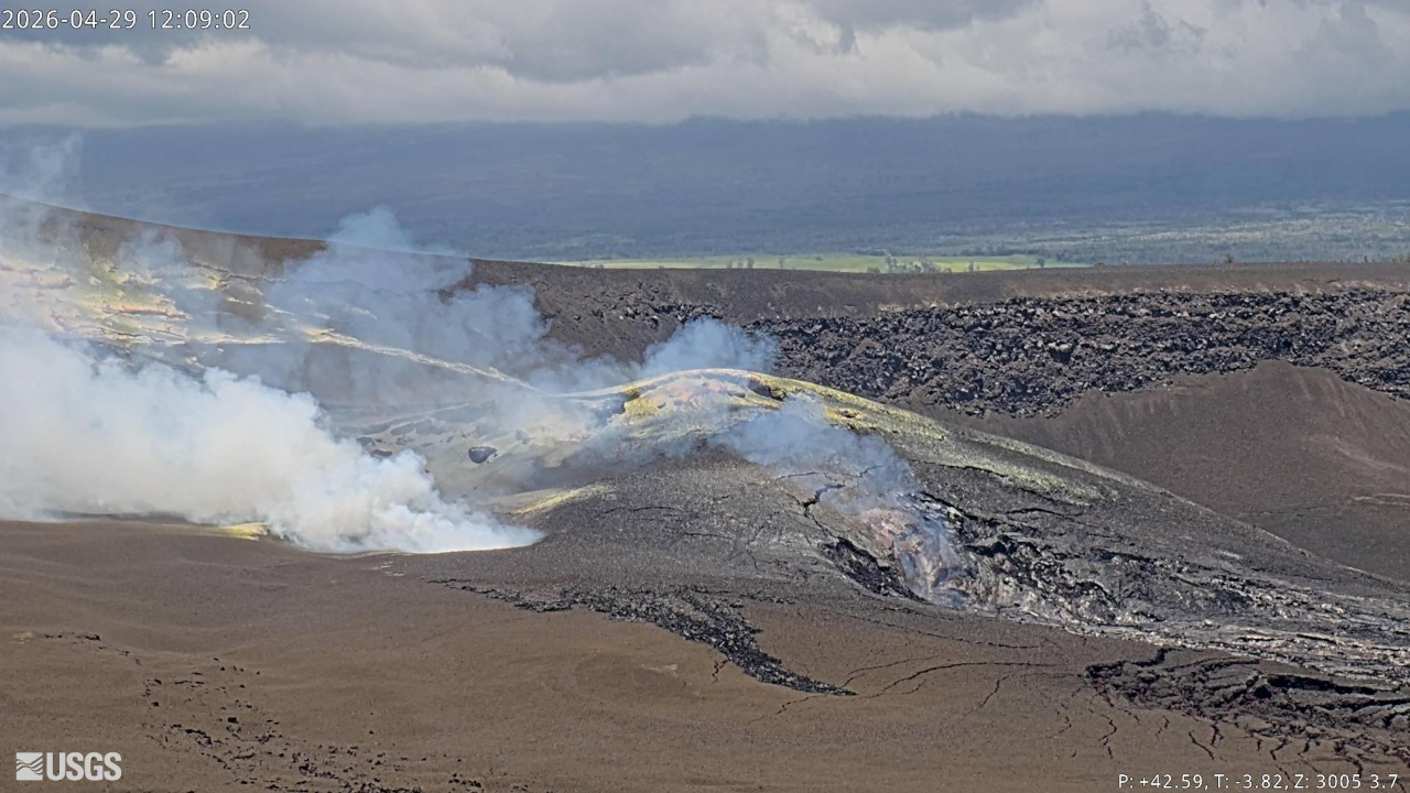
Seismic tremor and earthquake activity at the summit remain elevated, but stable. Tremor pulses over the past day have been weak and undefined. There were 21 small earthquakes recorded across the summit in the past day. The largest earthquake was 2.0M and occurred at a depth of 0.3 miles (0.5 km). All earthquakes beneath the summit region were located within 5.5 miles (9 km) depth, a majority confined within Halemaʻumaʻu crater and within 0.3 miles (0.5 km). Similar, small earthquake swarms have been concentrated under the caldera for the past month.
During episode 45, the Uēkahuna tiltmeter (UWD) recorded about 16.0 microradians of deflationary tilt. Currently, UWD continues to record positive tilt at a consistent rate (between 0.05 – 0.1 microradians every hour). Since the end of episode 45, UWD has recorded a total of 13.2 microradians of inflationary tilt. Fluctuations in tilt are normal during eruptive pauses.
With the eruption now paused, the SO2 emission rate is likely varying within a typical range of 1,000 to 5,000 tonnes per day.
Rift Zone Observations:
Rates of seismicity and ground deformation remain low in the East Rift Zone and Southwest Rift Zone. SO2 emissions from the East Rift Zone remain below the detection limit.
Source et photo : HVO
Colombia , Galeras :
San Juan de Pasto, April 28, 2026, 7:00 PM
Regarding the monitoring of activity at the Galeras volcano, the Colombian Geological Survey (SGC), an agency under the Ministry of Mines and Energy, reports the following:
During the week of April 21-27, 2026, the main variations in monitored parameters, compared to the previous week, were as follows:
● Volcanic activity remains low. No significant variation was recorded in the frequency or energy of earthquakes associated with Galeras. Most of the detected earthquakes correspond to rock fracturing processes within the volcanic edifice.
● Ten earthquakes were located within the volcanic zone of influence, less than 9 km from the crater and at a depth not exceeding 10 km from the summit of the Galeras volcano (4,200 m altitude). The maximum magnitude of this seismicity was 1.8 and no felt earthquakes were reported.
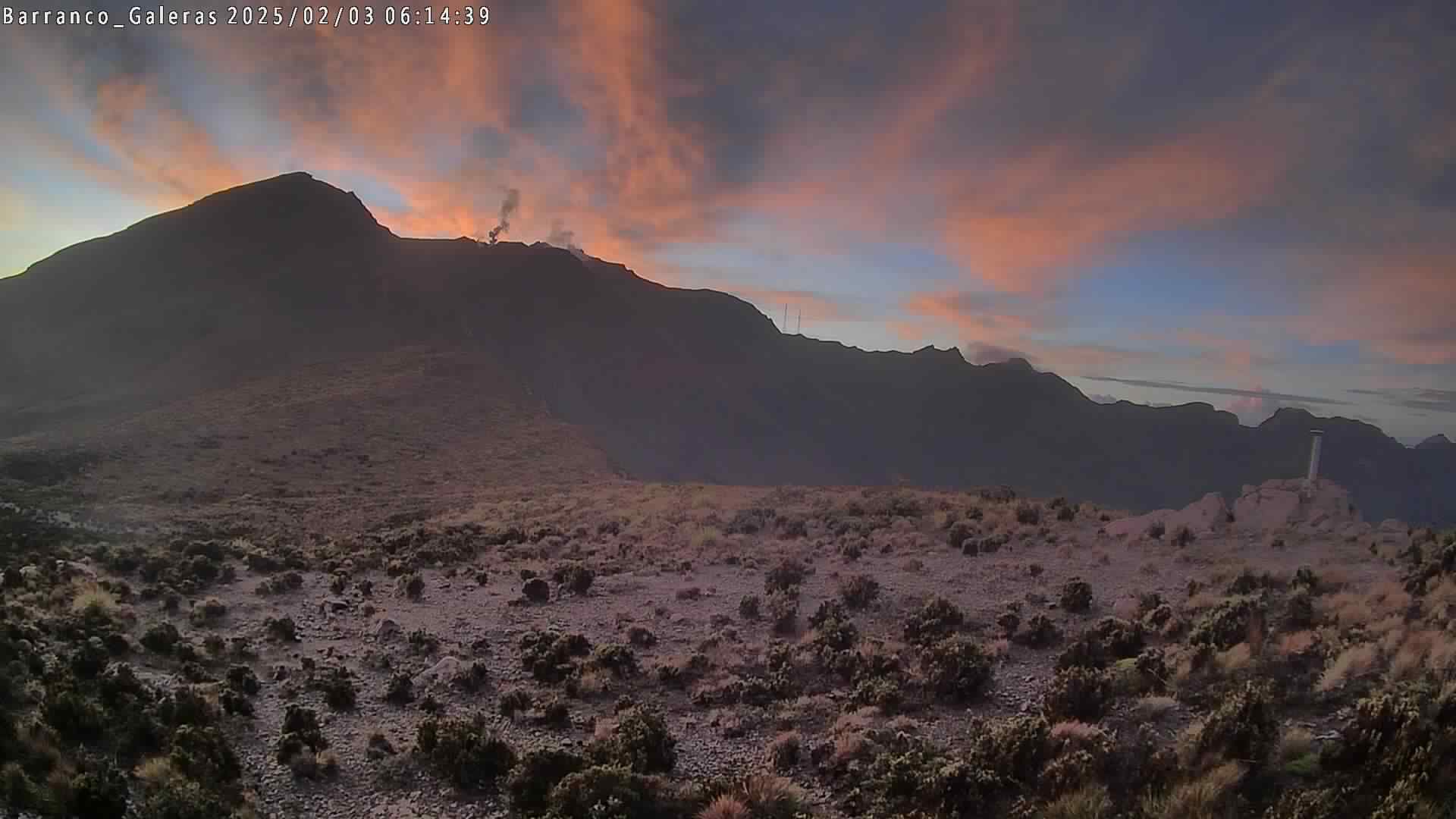
● Low-altitude plumes of white gas, dispersing variably depending on wind direction, have been observed. These originate primarily from the fumarole fields of El Paisita, to the north, and Las Chavas, to the west of the volcanic cone.
● All other volcanic monitoring parameters remained stable. Given these factors, the Geological Survey of Colombia (SGC) recommends closely monitoring the situation by consulting the weekly bulletins and other information published through its official channels, as well as the instructions of local and departmental authorities and the National Unit for Disaster Risk Management (UNGRD).
Volcanic activity remains at the yellow alert level: active volcano exhibiting changes in the baseline behavior of monitored parameters and other manifestations.
Source et photo : SGC.
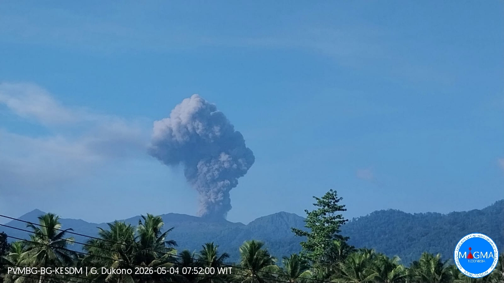
Indonesia , Dukono :
An eruption of Mount Dukono occurred on Monday, May 4, 2026, at 07:46 WIT, with an observed ash column height of approximately 1400 m above the summit (approximately 2487 m above sea level). This ash column, white to gray in color, was highly intense and directed north and northeast. At the time of writing, the eruption was still ongoing.
Seismic Observations
233 eruption earthquakes with amplitudes ranging from 7 to 34 mm and durations from 34.63 to 160.99 seconds.
One distant tectonic earthquake with an amplitude of 20 mm and a duration of 76.66 seconds.
Continuous tremor with an amplitude between 1 and 8 mm, predominantly 2 mm.
Recommendations
(1) Communities living near Mount Dukono and visitors/tourists are advised to refrain from any activity, climbing, or approaching the Malupang Warirang crater within a 4 km radius.
(2) Since eruptions with volcanic ash projection are periodic and the dispersion of ash depends on the direction and strength of the wind, making the coverage area unstable, communities near Mount Dukono are advised to always have masks/face coverings available to protect themselves from respiratory risks related to volcanic ash.
Source et photo : PVMBG.
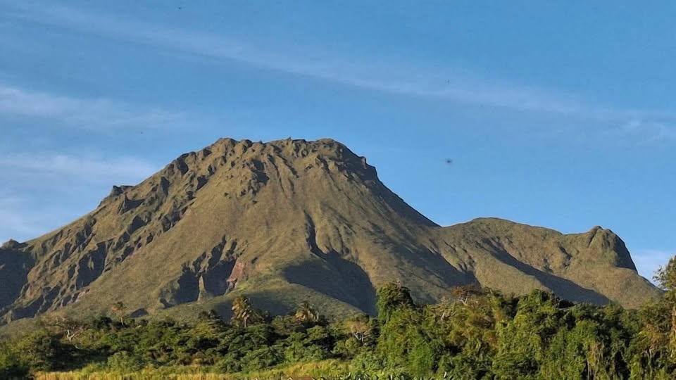
La Martinique , Mount Pelée :
Weekly Report, Paris Institute of Earth Physics / Martinique Volcanological and Seismological Observatory
Saint-Pierre, May 1, 2026, 6:45 PM local time (GMT-4)
Between April 24, 2026, 4:00 PM UTC and May 1, 2026, 4:00 PM UTC, the Martinique Volcanological and Seismological Observatory (OVSM) recorded 494 volcanic earthquakes:
• 488 volcano-tectonic earthquakes. Among them, 20 had a magnitude (local magnitude Mlv or duration magnitude Md) greater than 0.5, and 3 had a magnitude greater than 1. The largest occurred on April 28 at 7:23 AM local time and had a magnitude Mlv of 2.2. The others were of lower energy. The vast majority of these earthquakes are located at depths between 0.5 and 1.3 km below the volcano’s summit. However, two earthquakes were preliminaryly located at depths of 4.2 km and 5.5 km below sea level directly beneath Mount Pelée. This volcano-tectonic seismicity is associated with microfracturing within the volcanic edifice, linked to the overall reactivation of the volcano observed since 2019.
• Three shallow hybrid earthquakes and three long-period earthquakes were recorded. Two of these had a local magnitude (Mlv) greater than 0.5. The largest had a magnitude Mlv of 0.7. The others were of lower energy. These earthquakes were located in the same areas as the shallow volcano-tectonic earthquakes. The seismic signals of these types of earthquakes are enriched in (or contain only) low frequencies and are associated with the circulation of fluids (gas, hydrothermal fluids) in the volcanic edifice.
No earthquakes were felt by the population. However, the volcano-tectonic earthquake of April 28, with a magnitude of Mlv=2.2, has a magnitude approaching that of earthquakes likely to be felt by hikers on Mount Pelée.
The previous week, the OVSM (Swiss Volcanic Observatory) recorded 395 earthquakes of volcanic origin. As of May 1, 2026, and during the preceding four weeks, the OVSM has therefore observed a total of 1,590 volcanic earthquakes, an average of 397 to 398 earthquakes per week.
During phases of volcanic reactivation of volcanoes similar to Mount Pelée, it is common to observe seismic activity that varies in intensity and frequency. The probability of an eruptive activity in the short term remains low. However, based on observations accumulated in recent years, and particularly in recent months, a change in the situation in the medium term (weeks to months) cannot be ruled out.
The volcanic alert level, in accordance with the measures put in place by the authorities, is currently YELLOW: vigilance.
Source et photo : OVSM-IPGP
Guatemala , Santiaguito :
Atmospheric conditions: Partly cloudy
Wind: Northeast
Rainfall: 1.80 mm
Activity
The Santiaguito Volcanological Observatory reports relatively favorable conditions for observing the dome due to cloud cover. Weak to moderate explosions are reported at a rate of 2 to 3 per hour, projecting columns of gas and ash up to 800 meters in altitude. These columns are drifting southwest due to the wind. Incandescence may be visible on the dome, as well as the detachment of incandescent rock blocks to the west, southwest, and south. Ashfall is possible in La Tranquilidad, San Marcos Palajunoj, and surrounding areas due to the wind direction.
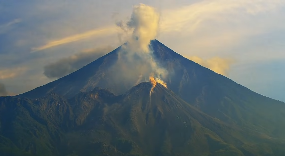
Due to the significant accumulation of rock material, the Caliente Dome and the promontory overlooking the lava flow could collapse and generate long-range pyroclastic flows to the southwest.
Therefore, it is recommended to follow the recommendations of Special Bulletin BESAN-016-2026.
Source : Insivumeh.
Photo : AFAR TV