March 10 , 2026.
La Réunion Island , Piton de la Fournaise :
Press release from the Paris Institute of Earth Physics / Piton de la Fournaise Volcanological Observatory, March 10, 2026 – 9:40 a.m. local time – 5:40 a.m. UTC
Eruption in progress
The eruption that began on February 13, 2026, shortly after 10:00 a.m. (local time) at Piton de la Fournaise continues.
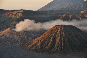
Only one eruptive site remains active on the south-southeast flank of the volcano, visible from Piton de Bert. The eruptive cone is now well-formed and continues to close progressively. Few ejecta now exceed the height of the cone.
With the lateral closure of the cone, significant lava tube activity is now established. Since March 3, lava flows have again been visible in the upper part of the Grandes Pentes, with a new flow arm.
The front of the southern arm of the lava flow, currently visible from Grand Brulé, was located 1.9 km from National Route 2 at 4:45 PM local time on March 9th, at an altitude of 478 m. This morning, around 5:30 AM, the front was located just over 1.7 km from National Route 2 and continued its slow advance. The front of the northern arm of the lava flow remains stationary at approximately 2.6 km from National Route 2, at an altitude of 660 m.
As in previous days, seismic activity remains low.
Inflation of the volcano, visible particularly on the summit GNSS stations and at the base of the terminal cone, continues. Since the end of February, the baselines crossing the summit have recorded an increase in distance, indicating a progressive re-expansion of the volcano.
This inflation indicates a repressurization of the magma supply system, possibly linked to magma recharge from the shallow reservoir.
Over the last 24 hours, eruptive tremor (an indicator of lava and gas emissions at the surface) has remained relatively stable. However, over the long term, the amplitude of the tremor shows a progressive increase since February 21. Some amplitude peaks are still being recorded, probably linked to variations in degassing or morphological changes in the eruptive cone. Surface flow rates, estimated from satellite data via the HOTVOLC platform (OPGC – Clermont Auvergne University), have been below 8 m³/s over the past 24 hours. It should be noted that these estimates can vary significantly depending on cloud cover and may even reach zero in the event of total cloud cover.
Alert Level 2.1
Source : OVPF/IPGP.
Photo : Lauzad
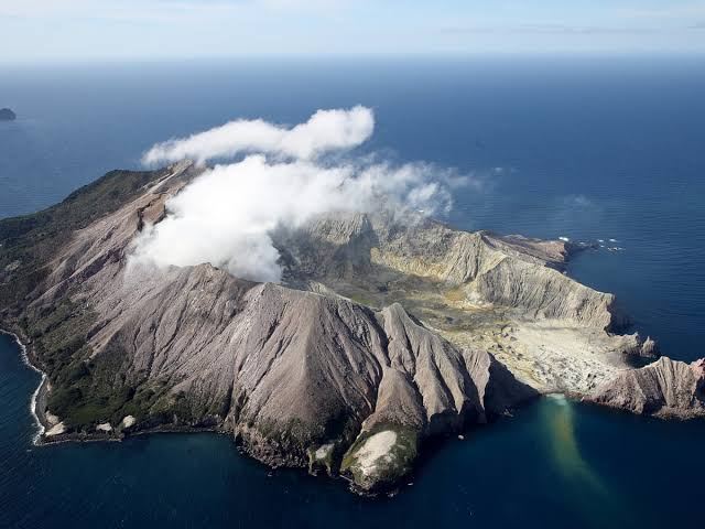
New Zealand , White Island :
Minor activity continues at Whakaari/White Island. Volcanic Alert Level remains at 2 and Aviation Colour Code at Yellow. Published: Tue Mar 10 2026 3:30 PM
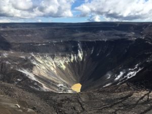
During the past week, white plumes of steam and gas have been visible from the Bay of Plenty coast and small amounts of sulphur dioxide gas have been detected by satellite sensors. Aircraft observations over the past weekend confirmed steam‑and‑gas being emitted from the active vent, but with no signs of erupted ash or rock on the crater floor. The Volcanic Alert Level remains at 2 and the Aviation Colour Code at Yellow.
On February 10th our thermal infrared imaging measured vent temperatures below 100 °C. Signs of small rockfalls (likely triggered by rainfall) were visible during that flight and were also seen in satellite (InSAR) imagery. This week’s camera views from the GeoNet Whakatane and Te Kaha sites show small low-elevation plumes that occasionally appear larger or different brown or grey colours depending on atmospheric conditions.
During last week, levels of Sulphur Dioxide (SO₂) gas detected by the TropOMI satellite were sometimes above the background. No associated ash was detected on those days. While this gas release is not unusual for the volcano, the detections are the first since November 2025.
These observations are consistent with the low‑level activity described in the previous update. Currently there is no eruption. However volcanic activity could escalate with little or no warning, potentially affecting the crater floor area and immediate vicinity of the island. Scientists have planned to make a gas-measuring flight this week, to determine changes in amounts of volcanic SO₂ and Carbon Dioxide (CO₂) gas being expelled.
Given our current lack of real-time monitoring data from the island, we cannot distinguish between Volcanic Alert Level (VAL) 1 and 2. As a result, Whakaari/White Island will remain at minimum at VAL 2 until on-island monitoring is reinstated.
Earth Sciences NZ’s Volcano Monitoring Group and National Geohazards Monitoring Centre will continue to closely monitor Whakaari/White Island for any changes in activity. Without sensors on the island, our monitoring continues to rely on remote cameras, satellite imagery, and periodic observation and gas flights to monitor Whakaari/White Island. We will provide further updates when information becomes available.
Source et photo: Geonet / Michael Rosenberg / Volcanologue de service.
Colombia , Cumbal :
San Juan de Pasto, March 3, 2026, 4:10 PM
Regarding the monitoring of activity at the Cumbal Volcanic Complex (CVC), the Colombian Geological Survey (SGC), an agency under the Ministry of Mines and Energy, reports the following:
During the week of February 24 to March 2, 2026, the main variations in monitored parameters compared to the previous week were as follows:
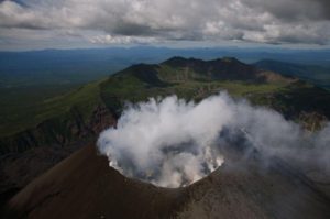
● In a context of low volcanic activity, a decrease in the number of earthquakes and their energy release was recorded. The most significant seismic contribution corresponded to rock fracturing processes within the volcanic edifice.
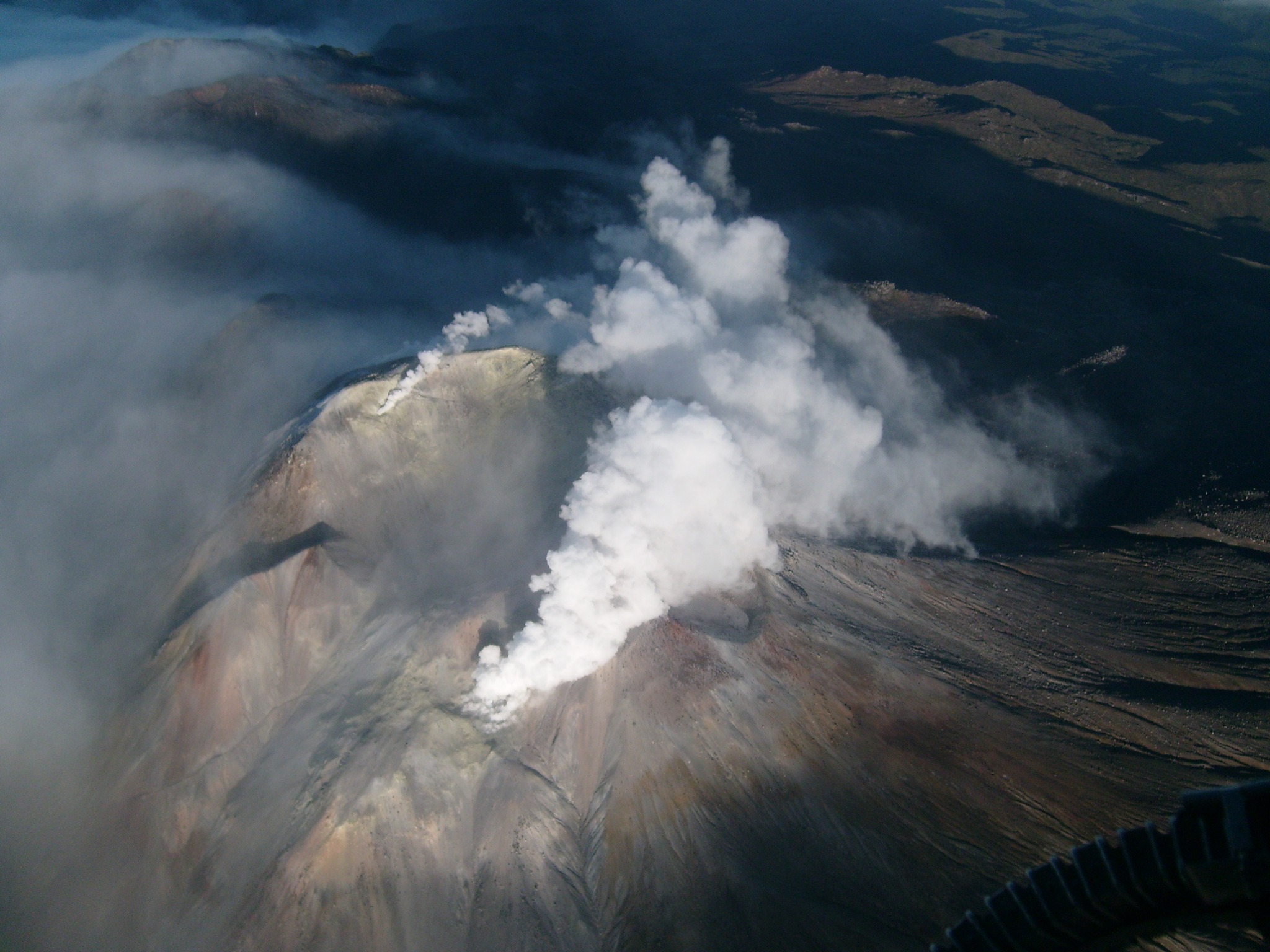
● Weak gas emissions were recorded at the Rastrojos, Boca Vieja, and El Verde fumaroles, with varying dispersion depending on wind patterns.
● Other volcanic monitoring parameters remained stable.
● In light of the above, the Colombian Geological Survey (SGC) recommends closely monitoring the situation through weekly bulletins and other information published via its official channels, as well as following the instructions of local and departmental authorities and the National Disaster Risk Management Unit (UNGRD).
Volcanic activity remains at the yellow alert level: active volcano exhibiting changes in the baseline behavior of monitored parameters and other manifestations.
Source et photo : SGC.
Guatemala , Santiaguito :
Atmospheric conditions: Clear skies
Wind: Northeast
Rainfall: 0 mm
Activity:
Activity is being recorded at the Caliente dome of the Santa María-Santiaguito volcanic complex. Weak white degassing fumaroles are observed 500 meters above the crater, along with weak to moderate explosions at a rate of 0 to 2 per hour, which are raising columns of gas and ash up to an altitude of 3,400 meters (11,155 feet). These columns are drifting southwest under the influence of the wind.
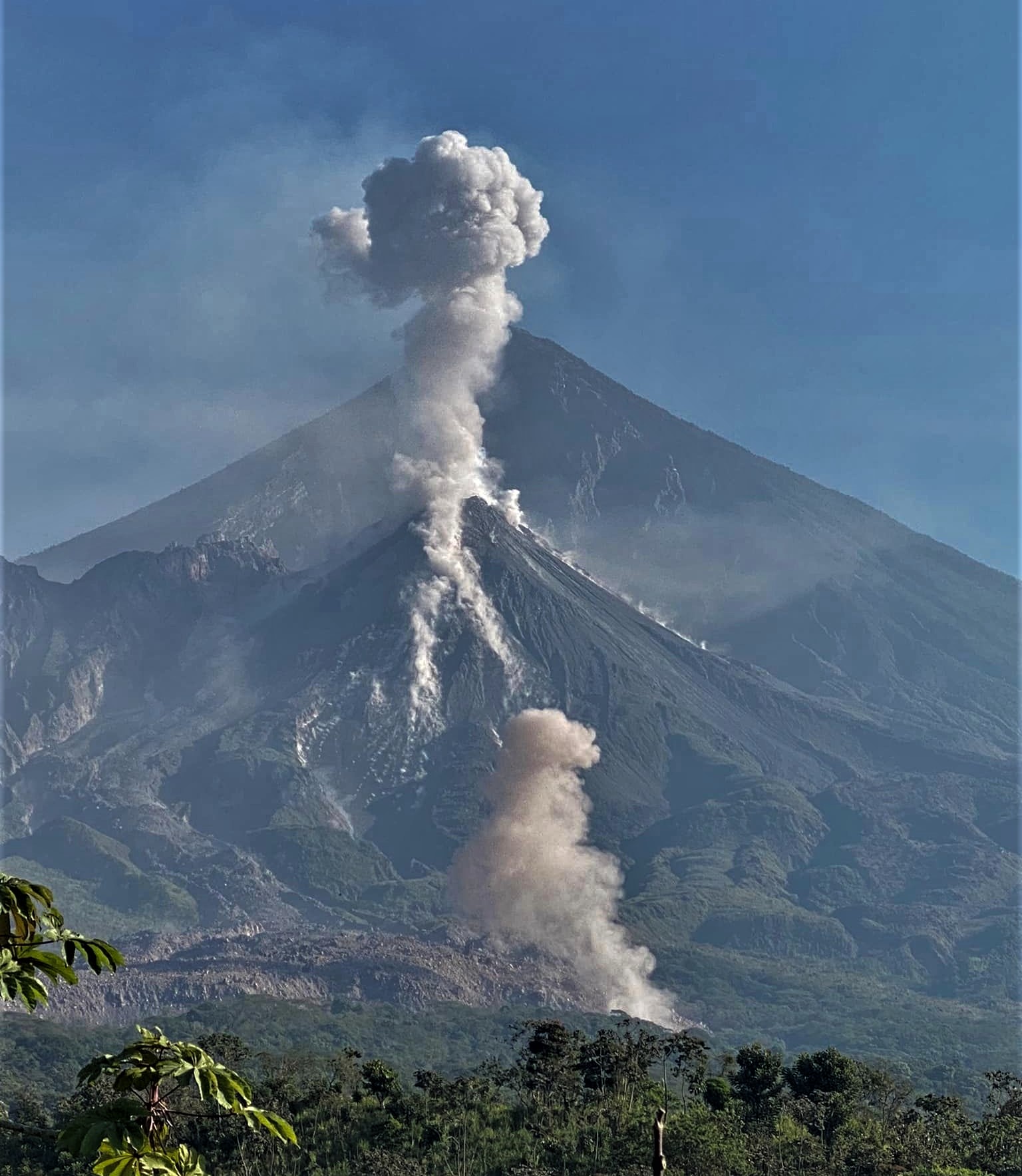
Incandescent blocks of rock are breaking away from the volcano’s flanks. Due to the wind direction, light ashfall is possible in the mountainous areas around the village of Monte Claro. Given the significant accumulation of rock material on the Caliente dome and the promontory overlooking the lava flow on its southwest flank, the formation of long-distance pyroclastic flows in all directions cannot be ruled out. Therefore, it is recommended to follow the guidelines of Special Bulletin BESAN-002-2026.
Source : Insivumeh .
Photo : Armando Pineda.
Alaska , Great Sitkin :
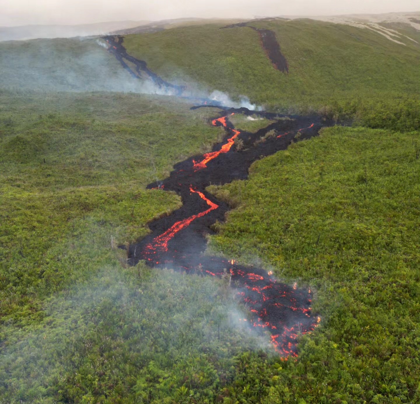
Lava continues to erupt slowly within the summit crater of Great Sitkin Volcano. Seismic activity remains low, with a few earthquakes and small rockfalls detected over the past day. Minor steaming and slow southward growth of the lava dome were observed otherwise cloudy satellite views.
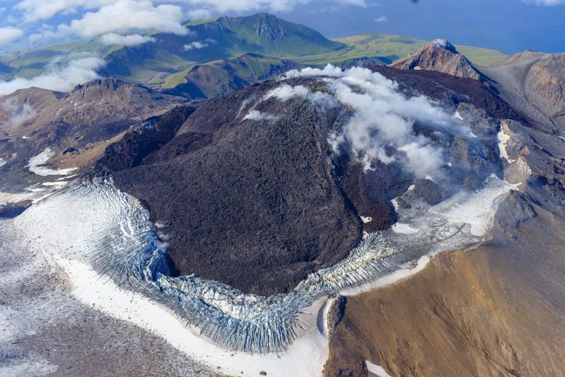
The current lava eruption began in July 2021 and, since then, has filled most of the summit crater and advanced into valleys below. There have been no explosions at Great Sitkin Volcano since an event in May 2021. The volcano is monitored using local seismic and infrasound sensors, satellite data, webcams, and regional infrasound and lightning networks.
Source : AVO.
Photo : Loewen, Matt / Alaska Volcano Observatory / U.S. Geological Survey.