February 27 , 2026.
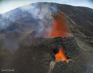
Italy , Stromboli :
Etna Activity Update, February 25, 2026, 3:27 PM (2:27 PM UTC).
The National Institute of Geophysics and Volcanology, Etna Observatory, announces that analysis of surveillance camera images shows moderate effusive activity in the North Crater area, producing a lava flow whose fronts are located in the upper part of the Sciara del Fuoco. From a seismic perspective, the average amplitude of volcanic tremor is currently within normal limits. No significant changes have been observed in the frequency and amplitude of explosion earthquakes.
No significant changes have been detected in GNSS network data.
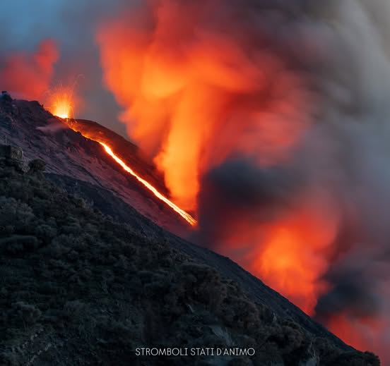
Etna Activity Update, February 26, 2026, 08:56 (07:56 UTC)
The National Institute of Geophysics and Volcanology, Etna Observatory, announces that analysis of surveillance camera images shows that the effusive lava flow activity reported on February 25, 2026, at 14:19 UTC has ceased. Strombolian activity continues in the North and Central-South crater areas. From a seismic perspective, the average amplitude of volcanic tremors has fluctuated between medium and high values since yesterday evening; around 3:30 UTC, this parameter stabilized at the average level. No significant changes have been observed in the frequency or amplitude of explosion earthquakes. No significant changes have been observed in the GNSS network data.
Further information will be released soon.
Source : INGV.
Photo : Stromboli stati d’animo / Sebastiano Cannavo.
La Réunion Island , Piton de la Fournaise :
Press release from the Paris Institute of Earth Physics / Piton de la Fournaise Volcanological Observatory, February 26, 2026 – 12:00 local time – 08:00 UTC
Eruption in progress
The eruption that began on February 13, 2026, shortly after 10:00 a.m. (local time), at Piton de la Fournaise continues.
Only one eruptive site remains active on the south-southeast flank of the volcano, with fountains still visible from Piton de Bert. A cone is forming through the accumulation of lava ejecta. This cone is gradually closing, while lava tube activity is developing downstream of the cone.
The lava flow front remains stationary in the lower part of the Grandes Pentes, approximately 2.6 km from the road and at an altitude of 660 m. The active parts of the lava flow remain concentrated near the eruptive site, before the Grandes Pentes fault, where the lava field widens and thickens.
Summit seismicity remains low: only one summit earthquake has been recorded in the last 24 hours. A decrease in the number of rockfalls has also been noted.
Surface deformations observed since the first days of the eruption indicated deflation of the summit area due to the rapid emptying of the shallow magma reservoir feeding the eruptive site (located approximately 1.5–2 km below the summit). This phase of rapid deflation is now over. At this stage, GNSS network data shows no significant trend.
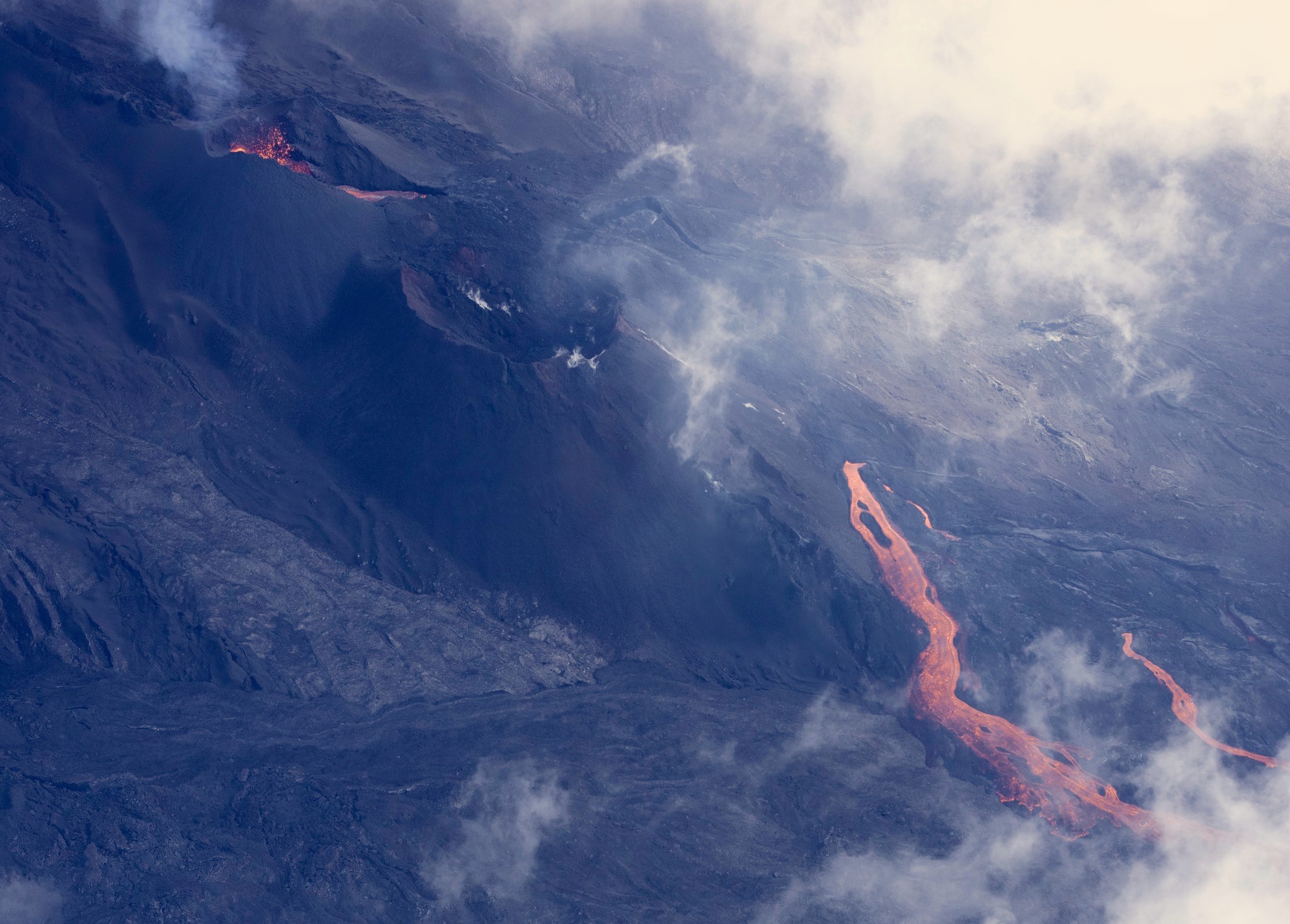
Image of the eruptive site taken on February 26, 2026, at approximately 9:30 a.m. (©University of Reunion Island / OVPF-IPGP).
The eruptive tremor (an indicator of lava and gas emissions at the surface) remains relatively stable and of low amplitude, with a slight downward trend over the last 24 hours. Surface flow rates, estimated from satellite data via the HOTVOLC (OPGC – Clermont Auvergne University) and MIROVA (University of Turin) platforms, have indicated values between 1 and 19 m³/sec over the last 24 hours. It should be noted that depending on cloud cover, these estimates can vary rapidly and become zero in the event of total cloud cover. Estimating surface lava flow rates allows us to track the volume of lava emitted at the surface; thus, since the beginning of the eruption, approximately 7 million cubic meters have been emitted at the surface.
Summary
The current absence of renewed inflation of the volcano, the low seismicity, and the relatively low levels of tremor and eruptive flow suggest that a balance has been established between the supply to the shallow reservoir and the volumes emitted at the eruptive site.
These observations reduce the short-term probability of a new fissure opening. However, the observatory remains vigilant. In the past, eruptive fissures have opened during eruptions without warning signals, such as in August 1998, July 1999, October 1999, December 2006, and March 2019. Indeed, magma propagation at shallow depths can occur aseismically, particularly when the magma has already been degassed.
Alert Level 2.1
Source et photo : OVPF/IPGP
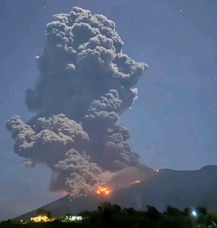
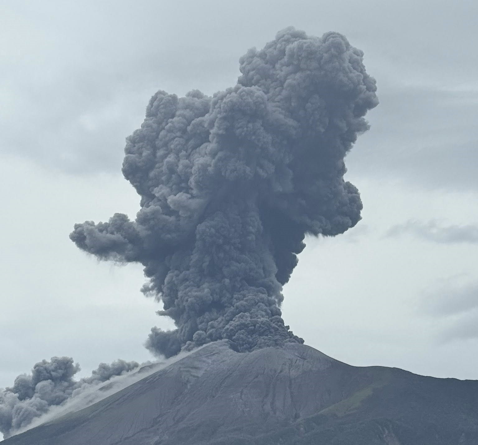
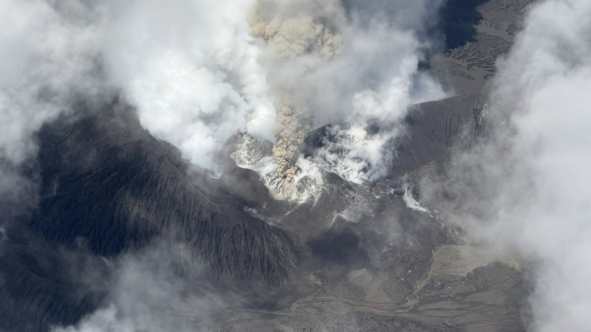
Philippines , Kanlaon :
KANLAON VOLCANO ERUPTION BULLETIN , 27 February 2026 , 2:00 PM
Eruption Data:
A short-lived, moderately explosive eruption occurred at the summit crater of Kanlaon Volcano at 07:04 PM yesterday, 26 February 2026, that lasted two (2) minutes based on seismic and visual recordings. The event was recorded by all 14 seismic-infrasound stations of the Kanlaon Volcano Network, as well as by six (6) stations of the Hibok-Hibok Volcano Network. The eruption generated a dense dark gray plume that rose 2,500 meters above the vent before drifting southwest; volcanic lightning was generated within the eruption plume at least three times. Incandescent ballistic fragments were launched as high as 1.5 kilometers from the summit crater and landed as far as one (1) kilometer on the south to 1.5 kilometers on the southeast, forming a briefly glowing collar on the summit area. Pyroclastic density currents or PDCs, hazardous mixtures of hot volcanic gas, ash and fragmented rock, descended the southeast and eastern upper slopes within two (2) kilometers of the summit crater.
The explosive onset generated a shock wave that was recorded at a maximum of 218 Pascals by an infrasound station approximately four kilometers southeast of the crater heard as a booming sound within 30 kilometers of the crater. Rumbling sounds attributed to the explosion were reported as far away as Southern Leyte, more than 175 kilometers east of Kanlaon Volcano, possibly due to atmospheric refraction of the explosion soundwaves. Two minutes after onset, activity transitioned into 77 minutes of continuous and profuse emission of ash that dispersed over the greater part of the southern Negros Island Region.
Eruption Impacts:
Due to high wind speeds of ~12 meters/sec at the 4-5-kilometer elevations, ash was dispersed over an extensive area of the Negros Island Region, with the heaviest ashfall experienced in the Municipalities of La Castellana and Pontevedra, Negros Occidental. Sulfurous fumes and shockwave observations were also reported. Regional, Provincial and local authorities have reported heavy to light ashfall on 121 barangays in 16 cities/municipalities of Negros Occidental .
In addition to the above impacts, incandescent ballistics and superheated PDCs ignited two patches of forest fire on the upper southern and southeastern margins of the forest canopy on the volcano slopes. The fires burned throughout the night and died out at approximately 08:19 AM today based on camera observations.
Monitoring Data Prior to the Eruption:
Yesterday’s eruption was preceded by only 9 volcanic earthquakes including four (4) low frequency events that are associated with volcanic gas activity, but all-in-all by relatively low seismic activity and volcanic gas emission in the past weeks. Sulfur dioxide or SO2 emission decreased to an exceedingly low average of 194 tonnes/day immediately prior to the eruption. In comparison, SO2 has been continuously degassed at an average rate of 2,800 tonnes/day since 3 June 2024, when eruptive unrest began, and of 1,460 tonnes/day since 1 January 2026. The Kanlaon edifice has been swelling or inflating at very low and fluctuating rates since 2022 due to magma intrusion at great depths beneath the volcano, with short-term inflation of the edifice that began in late January 2026 preceding eruption today based on electronic tilt and GPS data. These parameters indicate that blockage of already established volcanic gas pathways of a deep magma source (or closed-system degassing) and resulting pressurization and swelling of the edifice generated today’s moderately explosive eruption. This has been a repeating eruption mechanism since the volcano’s first moderately explosive activity in June 2024, producing nearly similar seismic characteristics and volcanic hazards.
Current Outlook:
Ash emission at the Kanlaon summit crater has resumed at 09:43 AM today, 27 February 2026, dispersing profuse ash southwest of the volcano. Alert Level 2 is currently maintained over Kanlaon Volcano but the alert status may be raised in the next few hours should unrest persist or worsen. This means that this most recent explosive eruption and ash emission events may possibly be followed by a return to moderate unrest conditions, similar to what has been experienced in recent explosions of the volcano, or by the onset of fully magmatic unrest. Such activity could produce dangerous volcanic hazards within the Lava and PDC Hazard Zones of the volcano, disperse ash over the general west to southwest and produce material that could feed lahars in affected drainage channels.
Recommendations:
It is strongly recommended that communities within the Four-Kilometer Permanent Danger Zone or PDZ remain evacuated due to the life-threatening hazards of pyroclastic density currents or PDCs, ballistic projectiles, rockfalls, volcanic gas and others that could be generated by similar explosive eruptions. Local government units must also prepare their communities within the PDC hazard zone, especially those within the six-kilometer radius, for subsequent evacuation in case unrest escalates and the Alert Level is raised. Communities that are affected by ashfall must be safeguarded from the health impacts of ash inhalation as well as from impacts on transportation safety, food and water resources and others. Communities that have already been impacted by recent lahars must remain vigilant in case intense rains occur and erode newly-deposited loose ash or pyroclastic material on the upper slopes to generate hot lahars and sediment-laden streamflow that can cause life-threatening injuries, washout and burial. Civil aviation authorities must also advise pilots to avoid flying close to the volcano’s summit as ash and ballistic fragments from sudden explosive eruptions can be extremely hazardous to aircraft.
DOST-PHIVOLCS maintains close monitoring of Kanlaon Volcano and any new development will be communicated to all concerned stakeholders.
Source : Phivolcs.
Photos : Makuy , Janeth Ignacio .
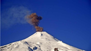
Vanuatu Archipelago , Ambae :
The Vanuatu Meteorology and Geohazards Department (VMGD) reported increased eruptive activity at Ambae during 12-13 February. Strong incandescence above the crater rim was visible in webcam images, and satellite data confirmed a strong thermal anomaly and high levels of sulfur dioxide emissions. Increased tremor was also detected by the seismic network. Ashfall and a sulfur odor was reported by residents downwind. Tremor was continuous during 14-15 February, though seismic data indicated that activity had decreased.
Strong incandescence was not visible in webcam images overnight during 14-15 February, nor observed by residents. High levels of sulfur dioxide emissions and moderate thermal anomalies continued to be identified in satellite images through the morning of 15 February. The Alert Level remained at 2 (on a scale of 0-5), and the public was warned to stay outside of Danger Zone A, defined as a 2-km radius around the active vents in Lake Voui, and to stay away from drainages during heavy rains.
Ambae, is a massive 2500 cu basaltic and the most voluminous active shield volcano of the Vanuatu arc. Its summit area shows two concentric calderas, the largest of which is 6 km in diameter and the smallest including three Lakes (Manaro-Ngoru, Manaro-Lakwa and Manaro-Voui). Manaro Voui now features an active crater formed after several recent lava flow events, with volcanic activity characterized by continuous gas emissions, primarily consisting of steam and sulfur dioxide.
Sources: Vanuatu Meteorology and Geohazards Department (VMGD) , GVP .
Photo : Unity Airlines Vanuatu .
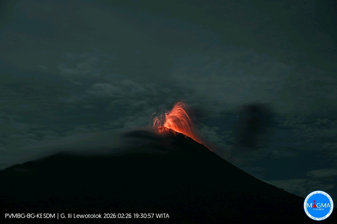
Indonesia , Ili Lewotolok :
An eruption of Mount Ili Lewotolok occurred on Thursday, February 26, 2026, at 7:30 PM (Western Indonesian local time). The observed ash column rose approximately 250 meters above the summit (at an altitude of about 1,673 meters). Grayish-black in color, this moderate to strong ash column drifted eastward. The eruption was recorded by a seismograph, with a maximum amplitude of 21.2 mm and a duration of 33 seconds.
Seismic Observations
58 eruption earthquakes with amplitudes ranging from 8.6 to 21.2 mm and durations of 33 to 47 seconds.
21 emission earthquakes with amplitudes ranging from 1.9 to 11.8 mm and durations of 29 to 43 seconds.
Recommendations
1. Residents living near Mount Ili Lewotolok, as well as visitors, climbers, and tourists, are advised to refrain from any activity or access within a 2 km radius of the Mount Ili Lewotolok activity center.
2. Be vigilant for the risk of lava avalanches and pyroclastic flows in the south, southeast, west, and northeast sectors of Mount Ili Lewotolok.
Source et photo : PVMBG.