May 1 , 2026.
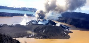
Philippines , Taal :
The Philippine Institute of Volcanology and Seismology (PHIVOLCS) reported eruptive activity at Taal during 22-29 April. The seismic network generally recorded 0-6 daily volcanic earthquakes; additionally, there were two periods of tremor lasting 1-3 minutes on 22 April, three periods on 28 April lasting two minutes to three hours and 14 minutes, and five periods on 29 April lasting 14 minutes to two hours and 10 minutes. Daily diffuse gas-and-steam emissions rose as high as 500 m above the crater rim and drifted SW. Minor phreatic eruptions during 01h57-02h07 on 25 April generated eruption plumes that rose 150-200 m above the crater rim.
That same day there were 25 volcanic earthquakes and 23 periods of tremor each lasting 1-29 minutes. Two minor phreatomagmatic events, each around two minutes long, occurred during 20h52-21h03 on 29 April and produced plumes that rose 400-600 m above the crater rim. One phreatic eruption that was four minutes long was also recorded that same day.
The Alert Level remained at 1 (on a scale of 0-5); PHIVOLCS reminded the public that the entire Taal Volcano Island (TVI) was a Permanent Danger Zone (PDZ) and recommended that the Main Crater and areas along the Daang Kastila fissure should remain prohibited. Pilots were warned to avoid flying over TVI.
Sources : Philippine Institute of Volcanology and Seismology (PHIVOLCS) , GVP.
Photo : Phivolcs.
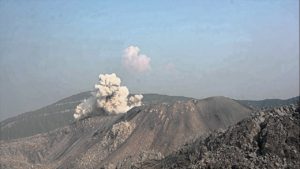
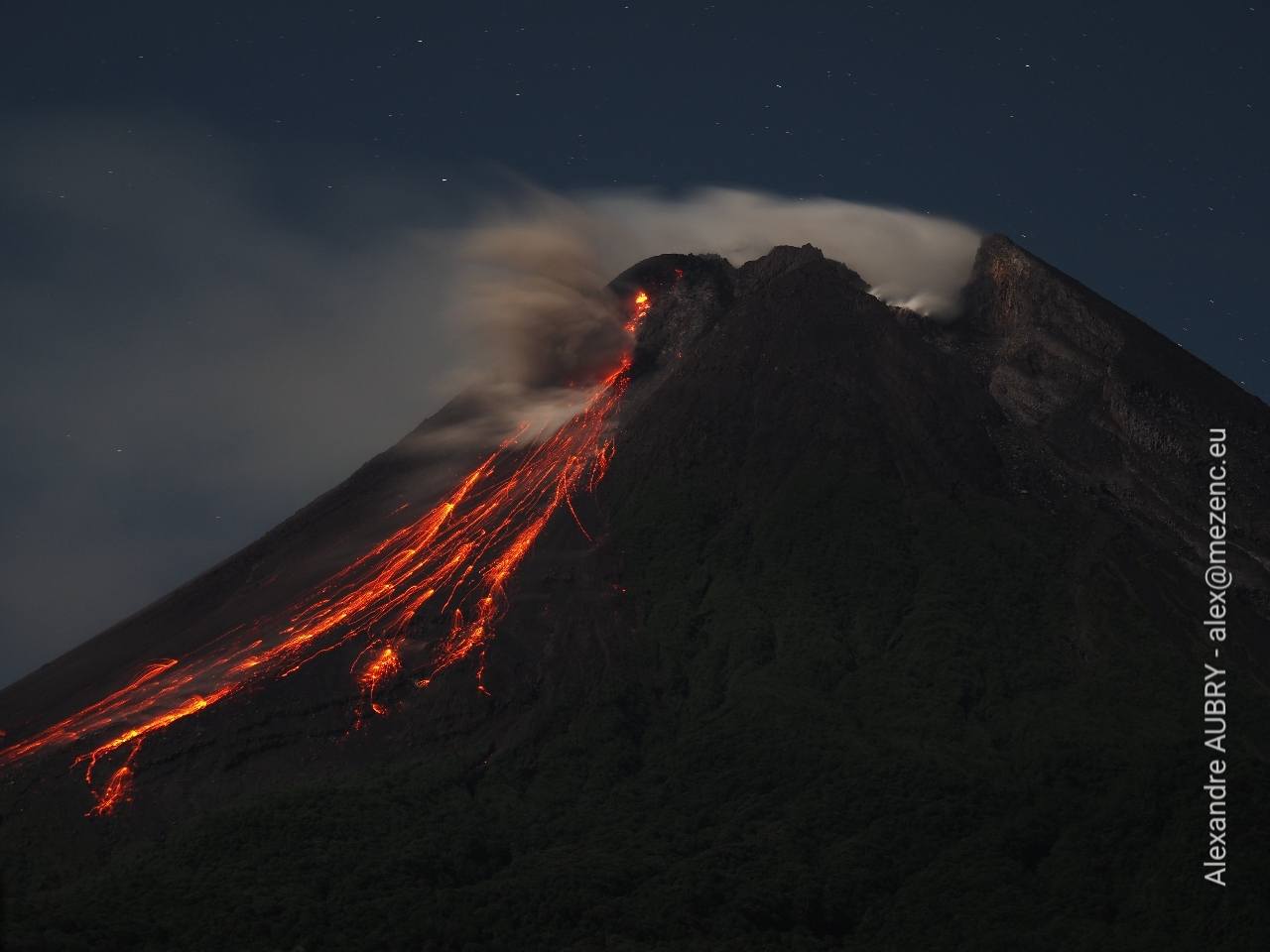
Guatemala , Santiaguito :
The Instituto Nacional de Sismología, Vulcanología, Meteorología e Hidrología (INSIVUMEH) reported ongoing eruptive activity at Santa Maria’s Santiaguito dome complex during 22-29 April, with continuing lava extrusion at Caliente dome. Incandescence at the summit was sometimes observed during dark hours. Daily explosions, 1-3 per hour when reported, generated gas-and-ash plumes that rose as high as 900 m above the dome and drifted as far as 20 km SW and W. Effusion of blocky lava and collapses of material produced daily incandescent block avalanches that descended the flanks, mainly to the W, SW, and S. The block avalanches were sometimes accompanied by short pyroclastic flows during 22-23 and 27-28 April; the latter pyroclastic flows generated ash plumes that rose 900 m above the dome and drifted W and SW. Lahars in the Nimá I and Tambor drainages on the S and SE flanks on 22 April and in the Nimá I drainage on 24 April carried tree trunks, branches, and volcanic blocks up to 1 m in diameter.
The lahar in the Tambor drainage was hot and had a sulfur odor due to the remobilization of pyroclastic flow deposits. Minor ashfall was reported in Las Marias (10 km S), Calaguaché (9 km S), Belén (10 km S), and other nearby areas during 22-23 April, and in La Tranquilidad (7 km SW), San Marcos Palajunoj (10 km SW), and the surrounding areas during 26-27 April. Several pyroclastic flows descended the S and SW flanks 2-4 km during 02h40-06h00 on 28 April, though weather clouds obscured visual confirmation. The pyroclastic flows were detected by the seismic network as peaks in Real-time Seismic Amplitude Measurement (RSAM) data.
Moderate amounts of ashfall were reported in local farms and communities on the S and SW flanks, and minor amounts fell in areas as far as 100 km W and SW. During 28-29 April block avalanches descended the flanks at a rate of 2-4 per hour. Minor ashfall was reported in Finca El Faro (7 km S), La Florida (6 km S), San Marcos Palajunoj, and surrounding areas.
Sources: Instituto Nacional de Sismologia, Vulcanologia, Meteorologia, e Hidrologia (INSIVUMEH) , GVP.
Photo : Edgar Cabrera / CONRED.
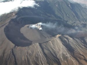
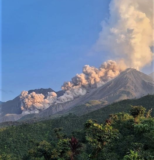
Indonesia , Merapi :
The Pusat Vulkanologi dan Mitigasi Bencana Geologi (PVMBG) reported that the eruption at Merapi (on Java) continued during 23-29 April with occasional lava avalanches produced by the active lava dome on the upper SW flank. Daily white plumes rose as high as 600 m above the summit on most days and drifted in different directions. On 23 April two lava avalanches descended the Sat/Putih drainage (W flank) as far as 2 km. The next day, on 24 April, four lava avalanches descended the Sat/Putih drainage and one pyroclastic flow traveled 1.5 km down the SW flank. On 25 April a total of 21 lava avalanches descended the Sat/Putih and Krasak (W flank) drainages as far as 2 km. There were 23 lava avalanches that descended the Sat/Putih drainage as far as 2 km on 26 April; the next day, 27 April, there were 33 lava avalanches that reached as far as 2 km down the Sat/Putih and Bebeng (SW flank) drainages. The Alert Level remained at 3 (on a scale of 1-4), and the public was warned to stay 3-7 km away from the summit, based on location.
Merapi, one of Indonesia’s most active volcanoes, lies in one of the world’s most densely populated areas and dominates the landscape immediately north of the major city of Yogyakarta. It is the youngest and southernmost of a volcanic chain extending NNW to Ungaran volcano. Growth of Old Merapi during the Pleistocene ended with major edifice collapse perhaps about 2,000 years ago, leaving a large arcuate scarp cutting the eroded older Batulawang volcano. Subsequent growth of the steep-sided Young Merapi edifice, its upper part unvegetated due to frequent activity, began SW of the earlier collapse scarp. Pyroclastic flows and lahars accompanying growth and collapse of the steep-sided active summit lava dome have devastated cultivated lands on the western-to-southern flanks and caused many fatalities.
Sources: Pusat Vulkanologi dan Mitigasi Bencana Geologi (PVMBG, also known as CVGHM) , GVP.
Photo : Alexandre Aubry / FB.
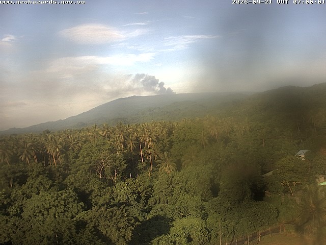
Vanuatu Archipelago , Ambae :
The eruption at Ambae continued during 24-25 April based on reports from the Wellington Volcanic Ash Advisory Center (VAAC). On 24 April sulfur dioxide emissions were identified in satellite images alongside a plume visible in webcam images; weather clouds prevented confirmation of ash. Weather clouds continued to obscure views for a few subsequent images. A diffuse ash plume was identified in a satellite image at 0915 on 25 April drifting SE at an altitude at or below 2.4 km (8,000 ft) a.s.l. The Alert Level remained at 3 (on a scale of 0-5), and the public was warned to stay outside of Danger Zone B, defined as a 3-km radius around the active vents in Lake Voui, and to stay away from drainages during heavy rains
The island of Ambae, also known as Aoba, is a massive 2,500 km3 basaltic shield that is the most voluminous volcano of the New Hebrides archipelago. A pronounced NE-SW-trending rift zone with numerous scoria cones gives the 16 x 38 km island an elongated form. A broad pyroclastic cone containing three crater lakes (Manaro Ngoru, Voui, and Manaro Lakua) is located at the summit within the youngest of at least two nested calderas, the largest of which is 6 km in diameter. That large central edifice is also called Manaro Voui or Lombenben volcano. Post-caldera explosive eruptions formed the summit craters about 360 years ago. A tuff cone was constructed within Lake Voui (or Vui) about 60 years later. The latest known flank eruption, about 300 years ago, destroyed the population of the Nduindui area near the western coast.
Sources: Wellington Volcanic Ash Advisory Center (VAAC), Vanuatu Meteorology and Geohazards Department (VMGD) , GVP.
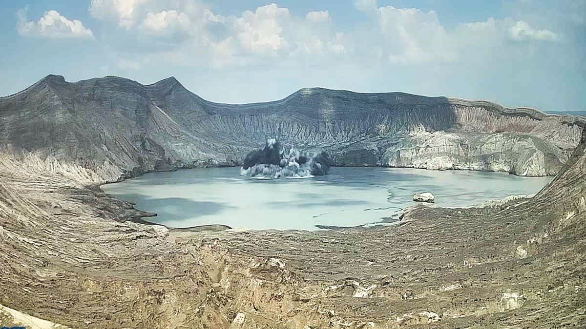
Colombia , Galeras :
San Juan de Pasto, April 28, 2026, 7:00 PM
Regarding the monitoring of activity at the Galeras volcano, the Geological Survey of Colombia (SGC), an agency under the Ministry of Mines and Energy, reports the following:
During the week of April 21-27, 2026, the main variations in monitored parameters, compared to the previous week, were as follows:
● Volcanic activity remains low. No significant variation was recorded in the frequency or energy of earthquakes associated with Galeras. Most of the detected earthquakes correspond to rock fracturing processes within the volcanic edifice.
● Ten earthquakes were located within the volcanic zone of influence, less than 9 km from the crater and at a depth not exceeding 10 km from the summit of the Galeras volcano (4,200 m altitude). The maximum magnitude of this seismicity was 1.8 and no felt earthquakes were reported.
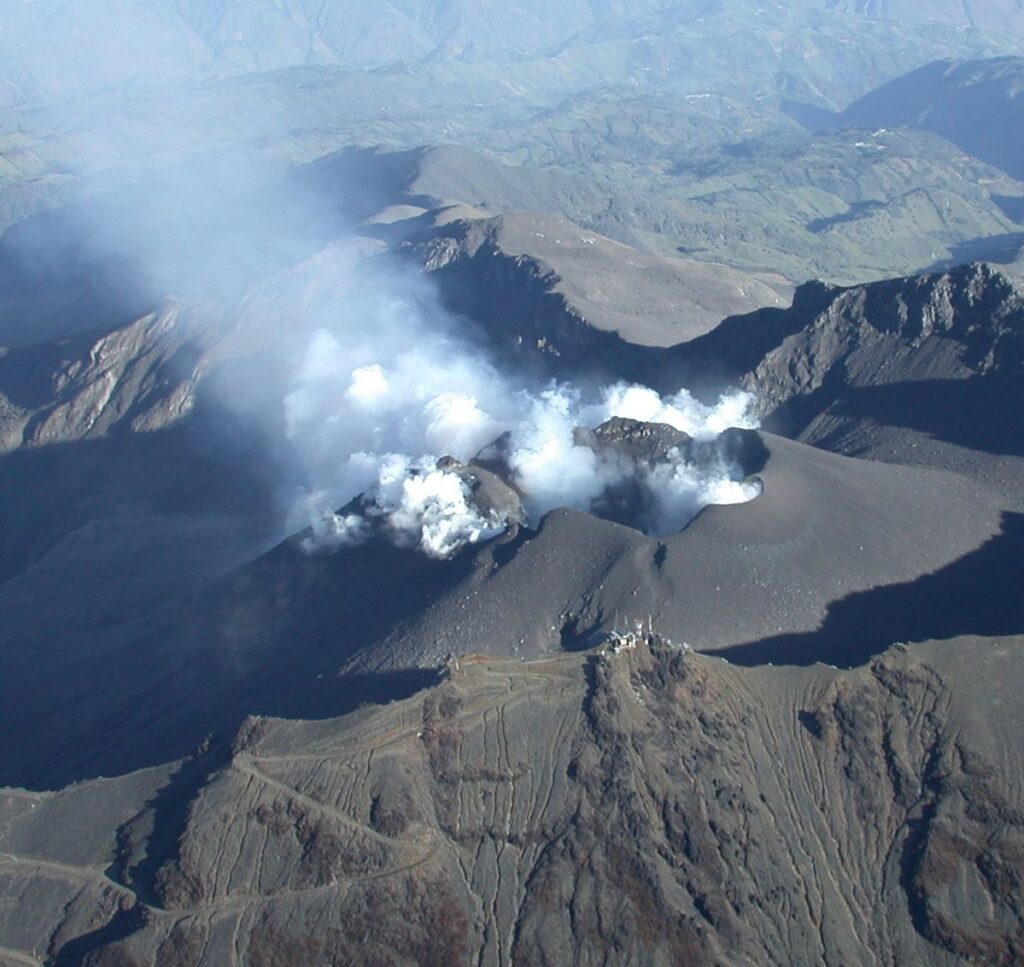
● Low-altitude plumes of white gas, dispersing variably depending on wind direction, have been observed. These originate primarily from the fumarole fields of El Paisita, to the north, and Las Chavas, to the west of the volcanic cone.
● All other volcanic monitoring parameters remained stable. Given these factors, the Geological Survey of Colombia (SGC) recommends closely monitoring the situation by consulting the weekly bulletins and other information published through its official channels, as well as the instructions of local and departmental authorities and the National Unit for Disaster Risk Management (UNGRD).
Volcanic activity remains at the yellow alert level: active volcano exhibiting changes in the baseline behavior of monitored parameters and other manifestations.
Source et photo : SGC.