February 23 , 2026.
Italy , Stromboli :
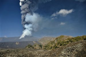
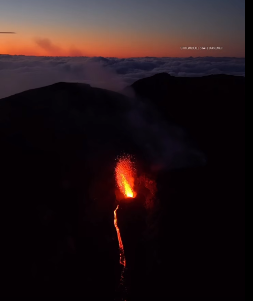
Stromboli Activity Update, February 22, 2026, 11:39 (10:39 UTC).
The National Institute of Geophysics and Volcanology, Etna Observatory, announces that analysis of surveillance camera images shows that the effusive lava flow activity reported on February 20, 2026, has ceased. Strombolian activity continues in the North and Central-South crater areas.
From a seismic perspective, the average amplitude of volcanic tremors is currently within the normal range. No significant changes have been observed in the frequency and amplitude of explosion earthquakes.
Ground deformation monitoring networks show no significant changes.
Further updates will be provided soon.
Source : INGV.
Photo : Stromboli stati d’animo / Sebastiano Cannavo.
La Réunion Island , Piton de la Fournaise :
Press release from the Paris Institute of Earth Physics / Piton de la Fournaise Volcanological Observatory. February 23, 2026 – 9:35 a.m. local time – 5:35 a.m. UTC
Eruption in progress
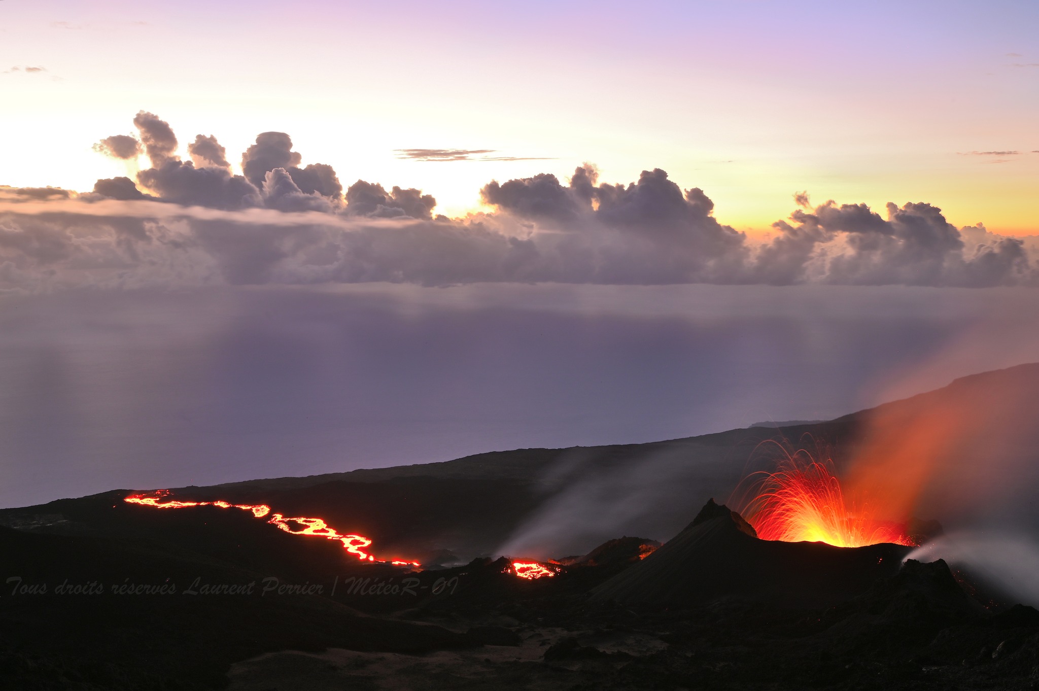
The eruption that began on February 13, 2026, shortly after 10:00 a.m. (local time), at Piton de la Fournaise continues.
Only one eruptive site remains active on the south-southeast flank of the volcano, with fountains still visible from Piton de Bert. A cone is forming through the accumulation of lava ejecta. This cone is closing, while lava tube activity is developing downstream of the cone.
The lava flow front remains stationary in the lower part of the Grandes Pentes, approximately 2.6 km from the road and at an altitude of 660 m.
The active parts of the flow are now always concentrated near the eruptive site before the break in the Grandes Pentes where the lava field widens and thickens.
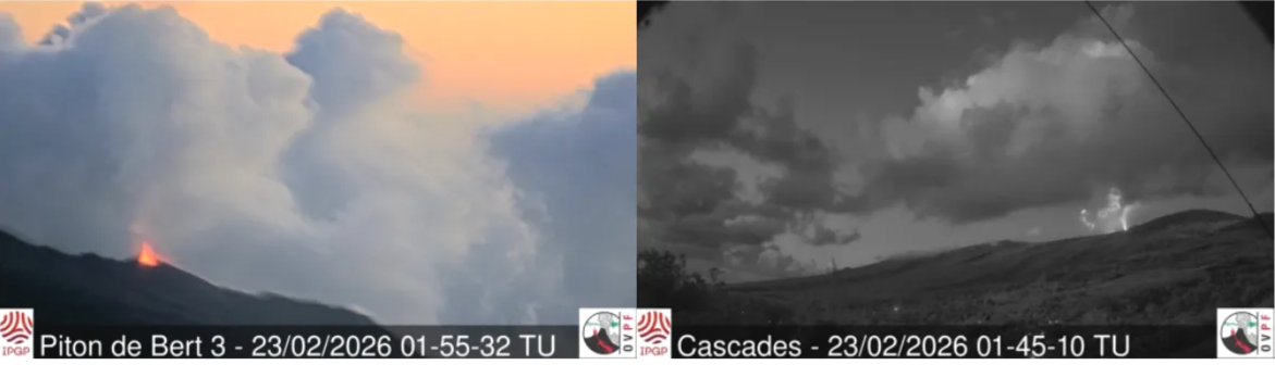
Images of the eruptive site from the IRT webcam located at Piton Bert (left) and the OVPF-IPGP webcam located at Piton des Cascades (right) (UTC: local time -4 hours) (©OVPF-IPGP).
The decrease in seismicity observed since the beginning of the eruption continues, with earthquakes mostly located between 1.6 and 2.1 km deep below the southern rim of Dolomieu.
Numerous rockfalls are still being recorded, both at the Dolomieu crater and at the eruptive site and recently emplaced lava flows.
Surface deformations observed since the first days of the eruption indicated deflation of the summit area due to the rapid emptying of the shallow magma reservoir feeding the eruptive site (reservoir located approximately 1.5–2 km deep below the summit). This phase of rapid deflation has now stopped. For the moment, no significant trend is emerging.
The intensity of the eruptive tremor (an indicator of lava and gas emissions at the surface) remains relatively stable with some minor fluctuations.
Surface flow rates, estimated from satellite data via the HOTVOLC (OPGC – Clermont Auvergne University) and MIROVA (University of Turin) platforms, have shown values over the last 24 hours ranging from 1 to 9 m³/sec. It should be noted that depending on cloud cover, these estimates can vary rapidly and be zero in the event of total cloud cover.
The current absence of renewed inflation of the volcano, the decrease in seismicity, and the relatively low levels of tremor and eruptive flow suggest the establishment of an equilibrium between the magma feeding the shallow reservoir and that emitted at the eruptive site, without significant repressurization of this reservoir.
These observations reduce the probability of a new fissure opening in the short term. However, the observatory remains vigilant, as eruptive fissures have opened during eruptions in the past without warning, such as in August 1998, July 1999, October 1999, December 2006, and March 2019. Indeed, magma propagation at shallow depths can occur aseismically, particularly when the magma has already been degassed.
Alert Level 2.1
Source : OVPF/IPGP.
Photos : OVPF , Laurent Perrier /MétéoR Océan Indien/ FB.
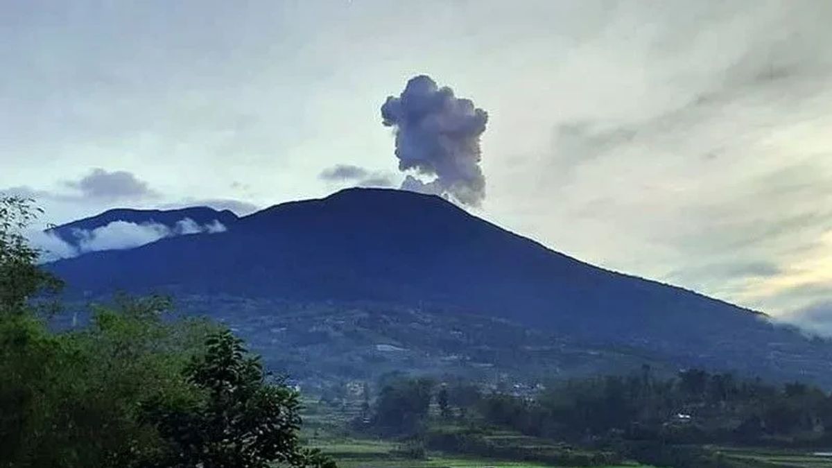
Indonesia , Marapi :
Mount Marapi experienced an eruption on Monday, February 23, 2026, at 2:18 a.m. West Indonesian Time (WIB). No visual observations of the eruption were made. The eruption was recorded by a seismograph with a maximum amplitude of 11.7 mm and a duration of 25 seconds.
Seismicity observations:
Two eruption earthquakes with amplitudes between 3.9 and 30.3 mm and durations of 23 to 41 seconds.
Six emission earthquakes with amplitudes between 0.8 and 1.8 mm and durations of 25 to 42 seconds.
Twelve non-harmonic tremors with amplitudes between 1 and 2.9 mm and durations of 65 to 228 seconds.
One deep volcanic earthquake with an amplitude of 1.2 mm and a duration of 14 seconds.
Two local tectonic earthquakes with an amplitude of 0.8 mm and durations of 18 to 31 seconds.
Four distant tectonic earthquakes with amplitudes between 2.3 and 30.5 mm and durations of 64 to 163 seconds.
A continuous seismic tremor with an amplitude of 0.5 to 1.5 mm, primarily 1 mm.
Recommendations
1. Communities living near Mount Marapi, climbers, visitors, and tourists are advised to refrain from all activities within a 3 km radius of the activity center (Verbeek Crater) of Mount Marapi.
2. Communities living near valleys, riverbanks, or streams originating at the summit of Mount Marapi are advised to remain vigilant for the risk of lahars (flash floods), particularly during the rainy season.
Source : Magma Indonésie.
Photo : Between
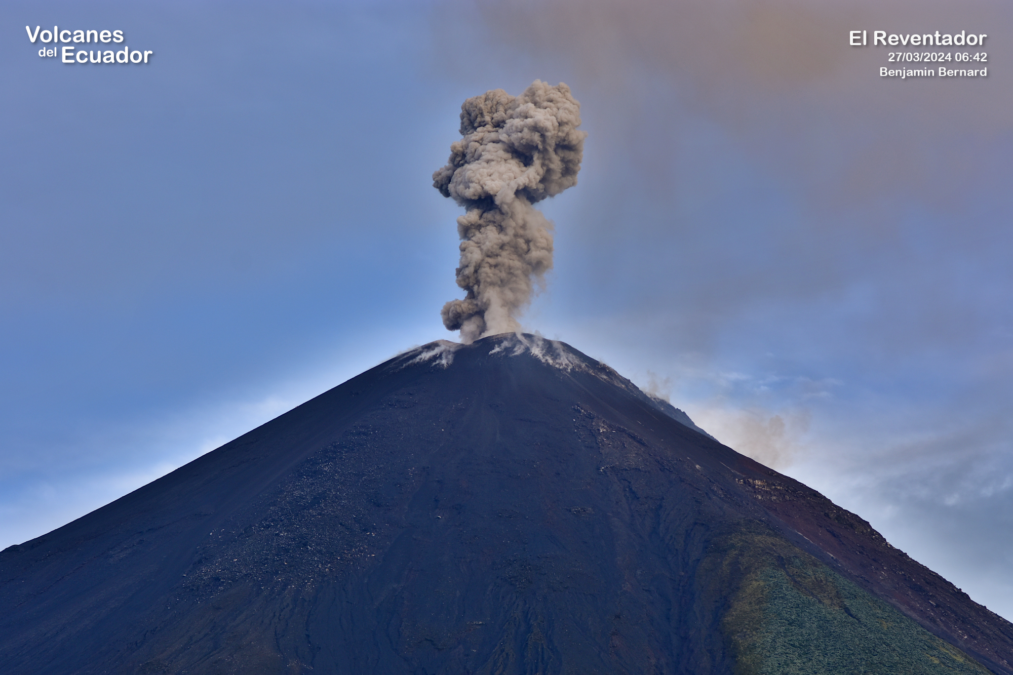
Ecuador , El Reventador :
REVENTADOR VOLCANO DAILY STATE REPORT, Sunday, February 22, 2026.
Information Geophysical Institute – EPN.
Surface Activity Level: High, Surface Trend: No Change
Internal Activity Level: Moderate, Internal Trend: No Change
From February 21, 2026, 11:00 AM to February 22, 2026, 11:00 AM:
Seismicity:
Explosions (EXP) 87
Long Periods (LP) 7
Emission Tremors (TREMI) 7
Harmonic Tremors (TRARM) 6
Rain/Lahars:
Precipitation was recorded in the volcano area, but it did not generate mudflows or debris. **In the event of heavy rainfall, accumulated material could be remobilized, causing mudflows and debris flows that would cascade down the volcano’s flanks and into nearby rivers.**
Emissions Column/Ash:
Due to data transmission problems, emissions could not be observed by surveillance cameras. However, using the GOES-19 satellite system, a gas and ash plume was detected drifting westward, reaching an altitude of less than 800 meters above the crater. Regarding this activity, the Washington VAAC issued two reports describing ash plumes drifting westward, reaching altitudes of 700 and 1,000 meters above the crater.
Note:
Since yesterday afternoon and until the writing of this report, the volcano remains completely obscured by clouds, according to the GOES-19 satellite system.
Alert Level – SGR: Orange
Source : IGEPN.
Photo : Benjamin Bernard.
Hawaii , Kilauea :
HAWAIIAN VOLCANO OBSERVATORY DAILY UPDATE , U.S. Geological Survey
Sunday, February 22, 2026, 7:57 AM HST (Sunday, February 22, 2026, 17:57 UTC)
19°25’16 » N 155°17’13 » W,
Summit Elevation 4091 ft (1247 m)
Current Volcano Alert Level: WATCH
Current Aviation Color Code: ORANGE
Activity Summary:
The Halemaʻumaʻu eruption of Kīlauea is paused. Episode 42 ended February 15 at 11:38 p.m. HST. Preliminary models suggest the likely forecast window for the onset of episode 43 lava fountaining is March 5-15.
No significant activity has been noted along Kīlauea’s East Rift Zone or Southwest Rift Zone.
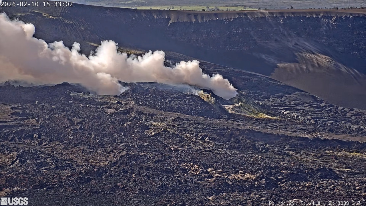
Summit Observations:
Weak glow from both vents was visible through the night. At the time of this report, both vents are quiet and emitting robust degassing plumes. Seismic tremor continues during the current pause. There were no shallow earthquakes located across the summit region during the past day.
The UWD tiltmeter has recorded a total recovery of nearly 14.0 microradians of inflationary tilt since the end of episode 42, with 2.4 microradians of that over the past 24 hours.
Plume geometry and weather prevented measurements of sulfur dioxide (SO2) emission rate during episode 42’s fountaining, but the emissions were likely in the range of 100,000 t/d, similar to during previous episodes. During pauses, like the current conditions, the SO2 emission rate from the summit has varied within a typical range of 1,000 to 5,000 tonnes of SO2 per day. This morning, webcams slack winds with the plume from the summit vents being carried to the southeast.
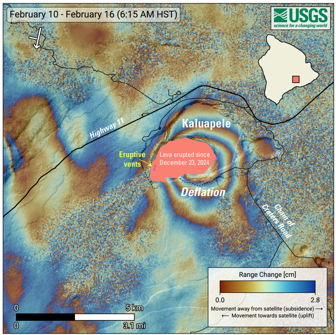
This map illustrates recent deformations of Kīlauea between February 10 and 16, 2026. The data were acquired by the European Space Agency’s Sentinel-1A/C satellites. Each color cycle represents a ground displacement of 2.8 cm (1.1 inches) between the satellite and the ground (distance change). The symbol in the upper left indicates the satellite’s orbital direction (arrow) and its line of sight (bar). The lava flows covering the crater floor are represented by the pink polygon, and the two vents (circles) are marked in purple. This radar interferogram, covering episode 42, shows rounded fringes inside and around Kaluapele (the summit caldera of Kīlauea), indicating a subsidence of the Earth’s surface during the period covered by the images, due to the withdrawal of magma from the magma chamber of Halemaʻumaʻu crater, at a depth of about 1.5 kilometers (1 mile) below the surface.
Rift Zone Observations:
Rates of seismicity and ground deformation remain very low in the East Rift Zone and Southwest Rift Zone. SO2 emissions from the East Rift Zone remain below the detection limit. Over night both the JKA and POC tiltmeters showed inflation of ~1 microradian, however this coincides with heavy rainfall at both tiltmeters that would have affected the tilt signals.
Source et photos : HVO.