February 13 , 2026.
La Réunion Island , Piton de la Fournaise :
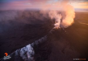
10:06 Eruption in progress
An eruption is currently underway within the Piton de la Fournaise caldera, south of the Dolomieu crater.
The prefect has activated alert level 2.1 of the ORSEC volcano emergency plan: eruption within the caldera.
Remain cautious.
Access to the caldera is strictly prohibited.
Alert Level 2.1 Activated
The Piton de la Fournaise Volcanological Observatory (OPVF) recorded a seismic crisis at 9:25 a.m. Volcanic tremor, indicative of magma rising to near the surface, has been recorded since 10:00 a.m. (local time).
Observations and data analysis show that eruptive fissures have opened near the summit on the volcano’s southern flank.
Consequently, the Prefect has activated alert level 2.1 of the specific ORSEC*volcano emergency plan: eruption within the caldera without any particular threat to the safety of people, property, or the environment.
Public access to the entire caldera of Piton de la Fournaise (upper section, lower section, and steep slopes), whether from the Pas de Bellecombe trail or any other trail, remains prohibited until further notice.
Please note that landing aircraft in the volcano area is regulated and subject to authorization from the prefecture.
At this time, the RN 2 highway remains open to traffic.
Hawaii , Kilauea :
HAWAIIAN VOLCANO OBSERVATORY DAILY UPDATE , U.S. Geological Survey
Thursday, February 12, 2026, 9:25 AM HST (Thursday, February 12, 2026, 19:25 UTC)
19°25’16 » N 155°17’13 » W,
Summit Elevation 4091 ft (1247 m)
Current Volcano Alert Level: WATCH
Current Aviation Color Code: ORANGE
Activity Summary:
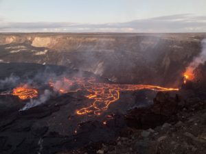
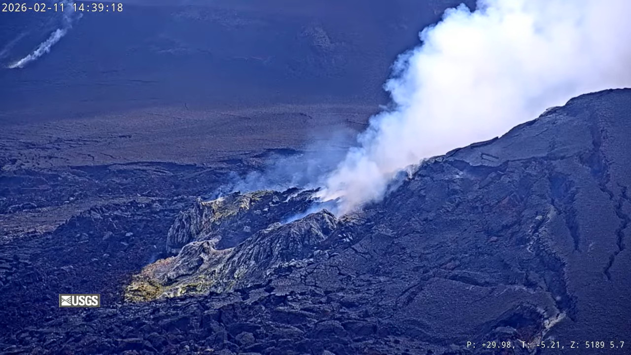
The Halemaʻumaʻu eruption of Kīlauea is paused. Summit inflation is ongoing today. Glow at both the south and north vents was visible in the webcams overnight. The forecast for the onset of episode 42 lava fountaining has been adjusted to February 13 through 17, with the most likely window between February 14 and 16 based on modeled inflation.
No significant activity has been noted along Kīlauea’s East Rift Zone or Southwest Rift Zone.
Summit Observations:
Moderate glow was visible at the south and north vents overnight in the webcams, with glow from the south vent slightly stronger.
Seismic tremor continued over the past 24 hours and has been relatively steady over the past day. Earthquake activity was low and 4 small earthquakes were located in the summit area during the past 24 hours.
The Uēkahuna tiltmeter (UWD) has gained 2.5 microradians in the past 24 hours. The net inflation since the end of episode 41 is now 28.1 microradians of inflationary tilt.
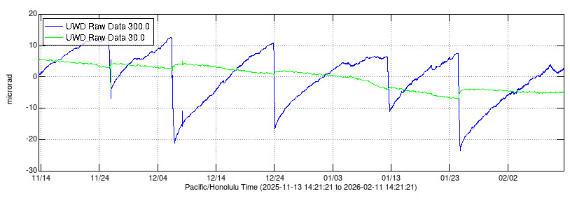
USGS: “Electronic Tilt at Kīlauea summit – Past Three Months. The different colored lines show tilt in a specific direction at a specific station (see the legend in upper left corner of each plot). Station UWD is located near Uēkahuna, on the western rim of Kīlauea’s summit caldera. These data are recorded by continuously operating electronic tiltmeter. Positive changes often indicate inflation of the magma storage areas beneath the caldera of Kīlauea, but may also result from heavy rainfall or, occasionally, instrumental malfunctions.” Note the dip, and rebound, on the right side of the graph, plotting the recent deflation at the summit.
In recent days, the sulfur dioxide (SO2) emission rate from the summit has varied within the typical range of 1,000 to 5,000 tonnes of SO2 per day, as has been observed during previous eruptive pauses. This is considerably lower than rates observed during lava fountaining episodes. This morning, webcams show that the plume from the summit vents is being carried to the southwest. The National Weather Service forecast for the Kīlauea summit region for today and tonight indicates northeast winds at 10-14 mph, with some higher gusts possible.
Rift Zone Observations:
Rates of seismicity and ground deformation remain very low in the East Rift Zone and Southwest Rift Zone. SO2 emissions from the East Rift Zone remain below the detection limit.
Source et photo : HVO.
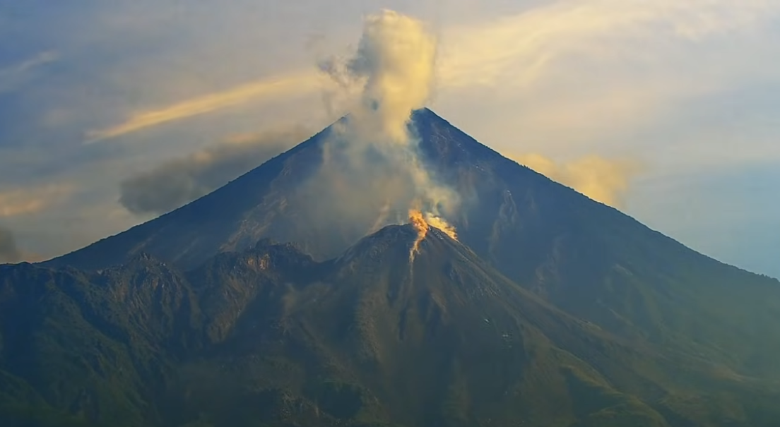
Indonesia , Mérapi :
The Pusat Vulkanologi dan Mitigasi Bencana Geologi (PVMBG) reported that the eruption at Merapi (on Java) continued 5-11 February. The SW lava dome produced pyroclastic flows or lava avalanches that descended the flanks on most days. One avalanche descended the Krasak (W) drainage 1.5 km on 6 February and three descended the drainage on 7 February, traveling as far as 1.6 km. Two pyroclastic flows were detected by the seismic network on 7 February. On 8 February two avalanches traveled 1.7 km down the Sat/Putih (W) drainage and three pyroclastic flows were detected by the seismic network. One pyroclastic flow descended the Krasak (W) drainage for 1 km on 9 February and one avalanche went 1.5 km down the same drainage. A pyroclastic flow descended the SW flank in the Krasak and Boyong drainages on 10 February and 10 avalanches traveled 1.8 km down the Krasak and Sat/Putih drainages. The Alert Level remained at 3 (on a scale of 1-4), and the public was warned to stay 3-7 km away from the summit, based on location.
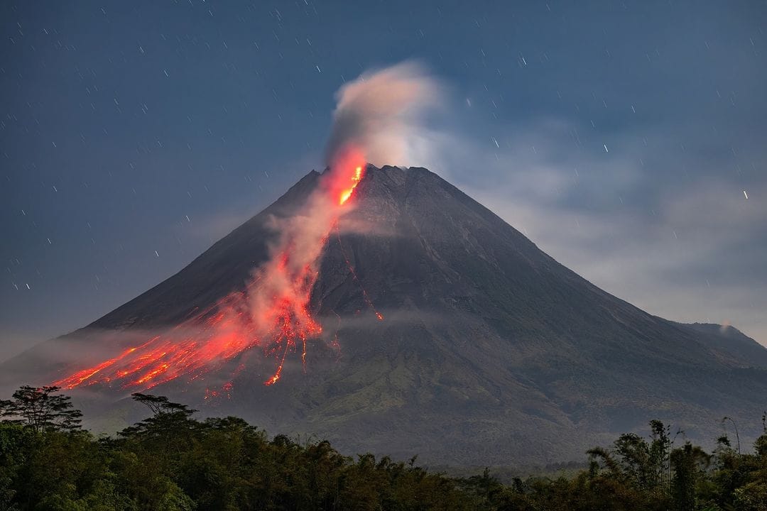
Merapi, one of Indonesia’s most active volcanoes, lies in one of the world’s most densely populated areas and dominates the landscape immediately north of the major city of Yogyakarta. It is the youngest and southernmost of a volcanic chain extending NNW to Ungaran volcano. Growth of Old Merapi during the Pleistocene ended with major edifice collapse perhaps about 2,000 years ago, leaving a large arcuate scarp cutting the eroded older Batulawang volcano. Subsequent growth of the steep-sided Young Merapi edifice, its upper part unvegetated due to frequent activity, began SW of the earlier collapse scarp. Pyroclastic flows and lahars accompanying growth and collapse of the steep-sided active summit lava dome have devastated cultivated lands on the western-to-southern flanks and caused many fatalities.
Sources: Pusat Vulkanologi dan Mitigasi Bencana Geologi (PVMBG, also known as CVGHM) , GVP.
Photo : Merapi news.
Kamchatka , Sheveluch :
The Kamchatkan Volcanic Eruption Response Team (KVERT) reported continuing eruptive activity at Sheveluch, from the domes along the N margins of Young Sheveluch, during 5-11 February. A daily thermal anomaly was identified in satellite images and explosions occasionally produced tall ash plumes. At 00h40 on 5 February explosions produced ash plumes identified in satellite images that rose to 9.8 km (32,200 ft) a.s.l. and drifted 42 km N. At 01h28 the Aviation Color Code was raised to Red (the highest level on a four-color scale). A few hours later explosions generated an ash plume that rose to 9 km (29,500 ft) a.s.l. and drifted 165 km NW. KVERT lowered the Aviation Color Code to Orange at 07h02, noting that no new ash emissions were identified. Later that day, at 23h20, explosions ash plumes from explosions rose to 10 km (32,800 ft) a.s.l. and drifted 33 km NW. The Aviation Color Code was raised to Red about an hour later, at 00h24 on 6 February. The Aviation Color Code was lowered back to Orange at 02h41; there were no new ash emissions, though a previous ash cloud was visible drifting 180 km NW at an altitude of 10 km. The Far Eastern Branch of the Russian Academy of Sciences (FEB RAS) reported that ash plumes around 05h20, 11h20, and 17h20 rose to 8.5 km (27,900 ft) a.s.l. and drifted NW according to Tokyo Volcanic Ash Advisory Center (VAAC) notices.
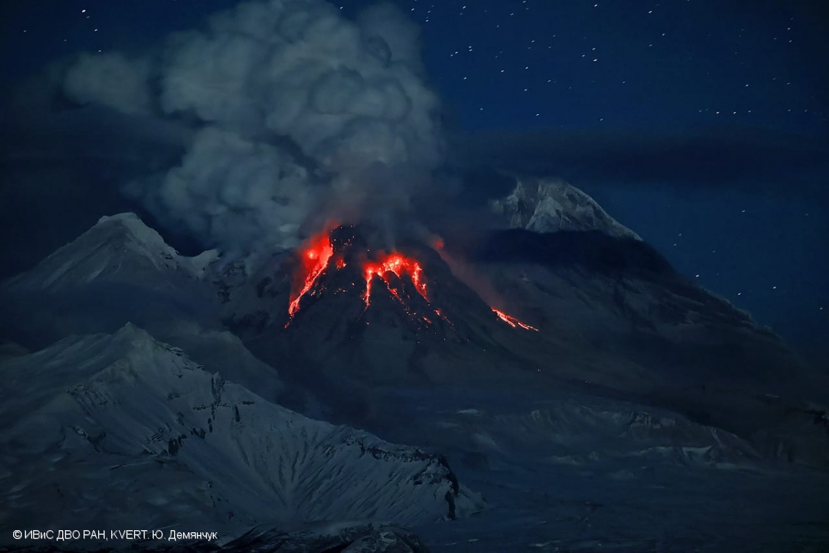
Explosions sent ash plumes to 10.5 km (34,400 ft) a.s.l. by 23h20 on 6 February, prompting KVERT to raise the Aviation Color Code to Red at 00h16 on 7 February. The ash plumes drifted 40 km NW. The Aviation Color Code was lowered back to Orange at 01h16 because there were no new ash emissions; a previous ash cloud was drifting 130 km NW at an altitude of 9 km. According to FEB RAS ash plumes rose as high as 6.7 km (22,000 ft) a.s.l. and drifted NW during 05h20-17h20. An ash plume from explosions rose to 11.6 km (38,100 ft) a.s.l. at 02h08 on 8 February and drifted 40 km NW. The Aviation Color Code was raised to Red at 03h53 and then back to Orange at 08h08. Satellite images showed an ash cloud at 9 km a.s.l. drifting 350 km NW. Weather clouds obscured satellite and webcam views on 9 February. At around 21h30 on 10 February steam, gas, and ash plumes were visible in webcam images rising to 4 km (13,100 ft) a.s.l. and drifting E based on a FEB RAS report. Dates are based on UTC; specific events are in local time where noted.
Sources: Kamchatkan Volcanic Eruption Response Team (KVERT), Institute of Volcanology and Seismology (IVS) of the Far Eastern Branch of the Russian Academy of Sciences (FEB RAS), GVP.
Photo : Yu. Demyanchuk, IVS FEB RAS, KVERT ( archive).
Guatemala , Santiaguito :
The National Institute of Seismology, Volcanology, Meteorology and Hydrology (INSIVUMEH) reported strong eruptive activity at the Santiaguito (Santa Maria) dome from February 4 to 11, with continuous lava extrusion at the Caliente dome. Daily explosions, ranging from one to four per hour when reported, generated plumes of gas and ash rising 700-800 meters above the dome and extending up to 20 kilometers to the west, southwest, southeast, and east. Blocky lava flows and collapses of incandescent material produced daily avalanches of burning blocks cascading down the flanks.
These avalanches were sometimes accompanied by short pyroclastic flows reaching the base of the cone; ash curtains were generated by these pyroclastic flows on February 9 and 10. Minor ashfall was reported in Calaguaché (9 km south), Pueblo Nuevo, Las Marías (10 km south) and surrounding areas on February 6 and 7, as well as in Loma Linda (7 km west), San Marcos Palajunoj (10 km southwest), Fincas El Rosario, Finca El Patrocinio (8 km southwest) and surrounding areas on February 9 and 10.
Sources : Instituto Nacional de Sismologia, Vulcanologia, Meteorologia, e Hidrologia (INSIVUMEH) , GVP.
Photo : AFAR TV ( capture d’écran)