December 29 , 2025.
Italy / Sicily , Etna :
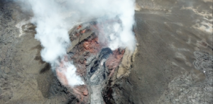
Etna Activity Update, December 28, 2025, 9:22 PM (8:22 PM UTC).
The National Institute of Geophysics and Volcanology, Observatorio Etneo, reports that over the past 24 hours, intense Strombolian activity has continued at the vent opened on December 27 on the upper eastern flank of the Voragine crater, generating frequent ash emissions and feeding an ash cloud being pushed by the wind toward the western sector of the volcano. Pyroclastic jets reached a height of 100 meters above the vent. The Northeast crater produced sporadic explosions last night and some ash plumes this morning; it has shown no signs of activity for several hours now.
The lava flow emitted from a vent at the eastern base of the Voragine crater, which was still flowing at dawn, appears to have stopped, with a few incandescent points along its path. The average amplitude of the volcanic tremor, as described in the previous press release, has remained almost stable, albeit at high levels. This tremor was observed until approximately 11:00 UTC this morning, then began a slight increase that continued until approximately 18:30 UTC.
Subsequently, the amplitude returned to values comparable to those observed last night and early this morning. The center of gravity of the volcanic tremor sources is located in the Northeast Crater area, at an altitude of approximately 2,600 to 2,900 meters above sea level. Infrasound events occurred at a low to medium frequency, with average amplitudes occasionally reaching high values. These events were localized to Bocca Nuova and, since approximately 8:45 PM UTC yesterday, only sporadically at the Northeast Crater. Analysis of ground deformation signals reveals no significant variations in the monitoring networks, thus confirming the overall stability described in the previous press release.
Further information will be released shortly.
Source : INGV.
Photo : Jenny Morella .
Indonesia , Gamalama :
Earthquake felt in Ternate and activity at Mount Gamalama, North Maluku, December 28, 2025.
Mount Gamalama, located on the island of Ternate in North Maluku, is one of Indonesia’s active volcanoes. Eruptions have been recorded there since 1538. Its activity level has been at level II (waspada) since March 10, 2015. The last eruption was recorded on October 4, 2018.
Visual observations (from December 16 to 27, 2025) revealed plumes of white smoke, of varying thickness, rising from 10 to 300 meters above the summit. Instrumental observations (from December 16 to 27, 2025) indicated that the seismic activity was primarily due to tectonic earthquakes (both local and distant).

On December 28, 2025, at 7:21 PM WITA (Central Indonesian Time), a powerful magnitude 2.9 earthquake struck, with its epicenter located southeast of Mount Gamalama. Volcanic seismic activity following this earthquake is being intensively monitored.
Mount Gamalama is currently on alert level II. This volcano still presents a risk of phreatic eruption, the main threat being the ejection of material from the main crater within a 1.5 km radius of the epicenter.
Source : PVMBG
Photo : IST
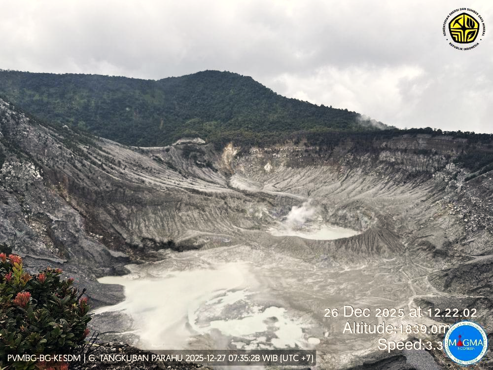
Indonesia , Tangkuban Parahu :
SPECIAL REPORT ON THE ACTIVITY OF TANGKUBAN PARAHU VOLCANO, WEST JAVA, DECEMBER 27, 2025.
Tangkuban Parahu is an active volcano located in the West Bandung and Subang districts of West Java province. It has nine craters, including two main summit craters: Ratu Crater and Upas Crater. Tangkuban Parahu eruptions are generally phreatic and originate from Ratu Crater.
From June to July 2025, an increase in low-frequency (LF) seismic activity was observed, peaking at 270 earthquakes on June 3, 2025. This increase was accompanied by mudflows in Ratu Crater. The smoke emitted from this crater was white, thin to moderately thick, and its pressure was low to moderate. It rose between 5 and 150 meters above the crater floor.
Seismic monitoring over the past three days has observed an increase in low-frequency (LF) earthquakes, with 10 events occurring on December 24, 2025, and another 10 on December 25, 2025. Seismicity records from December 26, 2025, counted 38 low-frequency (LF) earthquakes. Seismic monitoring of dV/V values showed no significant decrease, indicating the absence of a pressure increase due to upwelling of fluids. Visual observations of Ratu Crater reveal white smoke, of low to moderate pressure and low to moderate intensity, rising 5 to 80 meters above the crater floor. The smoke from the Ecoma crater is white, of low to moderate pressure and low intensity, rising 5 to 40 m above the crater floor.
Surface deformation observations using the EDM method, GNSS, and tiltmeters have not revealed any significant pressure variations beneath the volcano. EDM monitoring data show a deflationary trend in the Pillar-UPAS segment and an inflationary phase in the Pillar-LERENG segment, indicating shallow pressure fluctuations beneath the volcano’s body. This situation requires close attention, as a phreatic eruption could still occur suddenly without any apparent volcanic symptoms.
Based on these data, the activity level of Mount Tangkuban Parahu remains at Level I (Normal). Residents living near Mount Tangkuban Parahu and visitors are advised to avoid approaching the crater floor, not to linger in the active zone, and to leave immediately if the eruption intensifies or if a strong gas odor is detected. Although activity has decreased, vigilance remains essential. The regional government and the Regional Disaster Management Agency (BPBD) are requested to continue their coordination with the Tangkuban Parahu volcano observation post, located in the village of Cikole, and the Bandung Center for Volcanology and Geological Hazard Prevention.
Source et photo : PVMBG
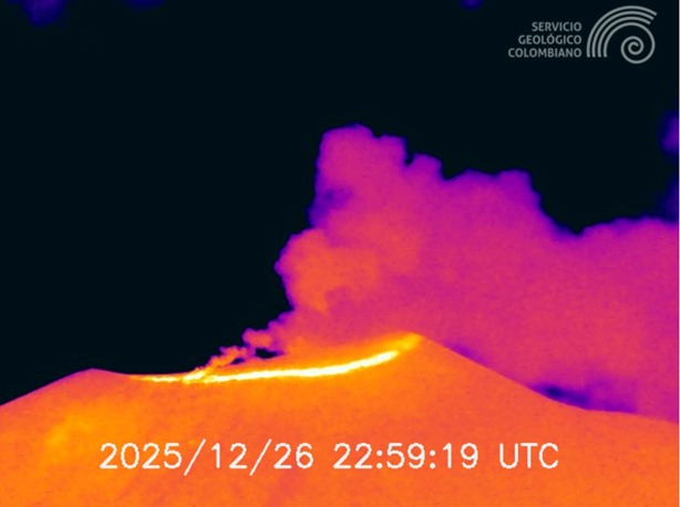
Colombia , Puracé / Los Coconucos volcanic chain :
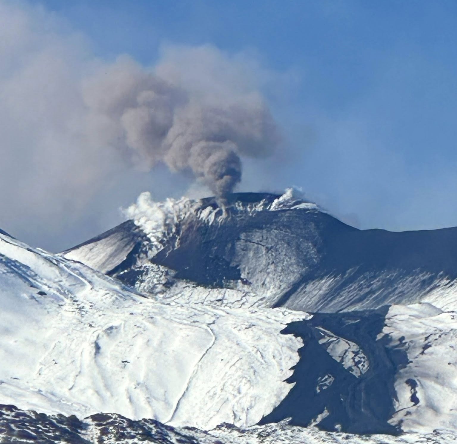
Popayán, December 28, 2025, 9:00 AM
Regarding the monitoring of activity in the Los Coconucos volcanic chain, the Colombian Geological Survey (SGC), an agency under the Ministry of Mines and Energy, reports the following:
Since the publication of yesterday’s extraordinary bulletin, and continuing to this day, earthquakes related to fluid movements within the volcanic edifice have persisted. These include long-period (LP) earthquakes, tremor pulses (TR), and continuous tremor. This seismicity has been located beneath the Puracé volcano crater, at a depth of less than 1 km, and is linked to the internal dynamics of gases and their release into the atmosphere. Among these seismic signals, two (2) were associated with ash emissions, for which alerts have been issued to the Civil Aviation Authority. The plumes reached heights of between 300 and 400 m above the summit of the volcano, with a predominant dispersion towards the Southwest and South.
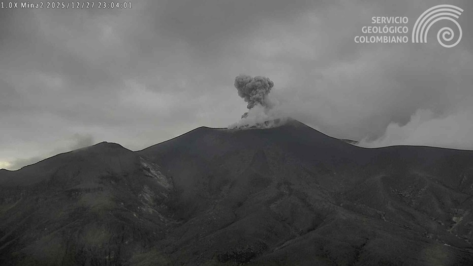
Recording from the Mina2 camera located 2.2 km north of the Puracé volcano. This gas and ash emission was recorded at 6:01 PM (local time) on December 27, 2025.
In addition, low-magnitude seismic signals, associated with rock fracturing processes, continued to be recorded, primarily beneath the Puracé and Piocollo volcanoes, at depths between 1 and 3 km.
Significant emissions of sulfur dioxide (SO₂) into the atmosphere continue to be detected, and temperatures similar to those observed in previous days are still being recorded in the crater area, possibly linked to the emission of hot gases from within the volcano. Constant degassing persists through the fissure on the northern wall of the Curiquinga volcano crater, without any ash emissions.
As long as the orange alert level remains in effect, temporary fluctuations in volcanic activity are possible, meaning it may sometimes decrease compared to previous days or weeks. However, this does not necessarily mean that the volcano has returned to a stable level of activity.
Given the above, the Geological Survey of Colombia (SGC) recommends staying away from the Puracé volcano crater and its surroundings, and closely monitoring the current situation through special bulletins and information published on our official channels, as well as following the instructions of local and departmental authorities and the National Unit for Disaster Risk Management (UNGRD).
Volcanic activity remains at ORANGE alert: Volcano with significant variations in monitored parameters.
Source et photos : SGC.
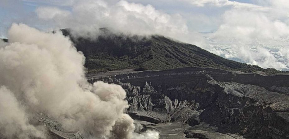
Costa Rica , Poas :
Latitude: 10.20°N
Longitude: 84.23°W
Altitude: 2,687 m
Current Activity Level: Alert
No eruptive activity has been recorded this week. However, background seismic tremor has intensified, with slight variations in the dominant frequency between 1 and 5 Hz. The level of seismic energy released (SEER) has increased, exceeding that observed in recent months. This is the highest level since the end of May 2025. Acoustic tremor remains very weak and very stable. The number of long-period events has decreased compared to last week. The geodetic network is recording subsidence of the volcano, although in recent days, an elongation of a few millimeters of the baseline has been detected between the north and south sides of the crater.
The MultiGAS stations measured an average SO₂/CO₂ ratio of 1.1 ± 0.4 this week, similar to last week’s value (1.0 ± 0.3). The H₂S/SO₂ ratio remained low (0.05 ± 0.03).
The ExpoGAS station at the Visitor Lookout measured a maximum of 1.6 ppm of SO₂ this week, representing a low to moderate concentration. The DOAS stations detected an SO₂ flux of 190 ± 70 t/d, similar to the previous week’s (199 ± 62).
Source : Ovsicori
Photo : Ovsicori archive