September 01 , 2025.
Italy / Sicily , Etna :
Etna Activity Update, August 31, 2025, 9:32 PM (7:32 PM UTC).
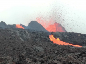
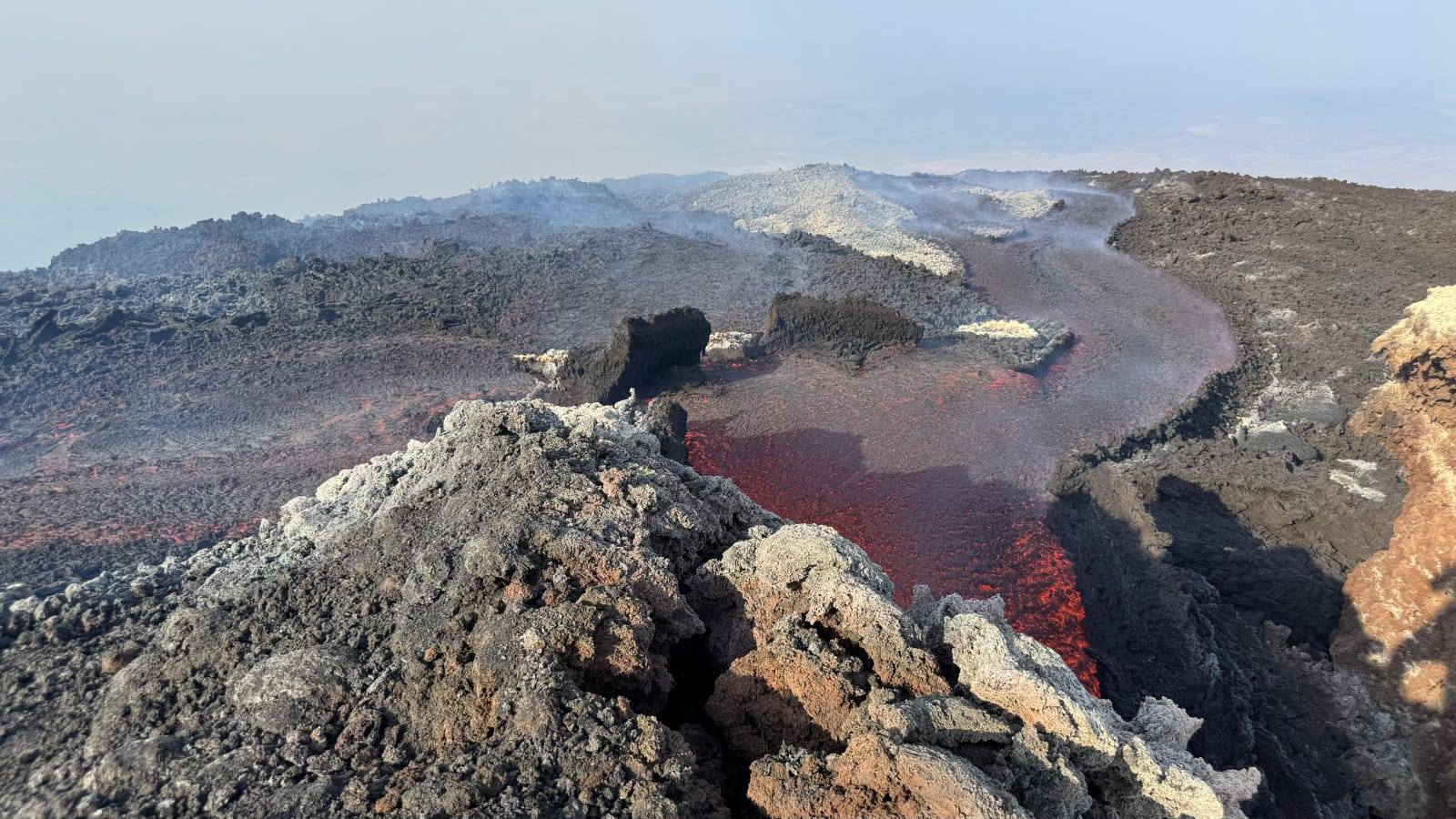
The National Institute of Geophysics and Volcanology, Osservatorio Etneo, reports that, based on analysis of surveillance images, satellite images, and field observations in the summit area, Strombolian activity at the Southeast Crater gradually decreased throughout the morning, both in intensity and in the number of explosions. However, until the afternoon, rare and weak emissions of very dilute ash were observed, which quickly dispersed in the summit area. Regarding effusive activity, the vent at 3,200 m is inactive, and the associated lava field is dormant and cooling. Lava emission from the vent at 2,980 m (9,000 ft) above sea level continues, although its rate of increase is gradually decreasing. From a seismic perspective, starting at 22:00 UTC on August 29, a moderate and continuous decrease in the average amplitude of volcanic tremor was observed. At 07:00 UTC today, the tremor amplitude then showed an even more rapid downward trend, reaching low values around 10:00 UTC, then oscillating between low and medium values in the following hours until the current state.

With a slight variation from previous days, the sources of the volcanic tremor this morning appear to be limited to an area located just northeast of the Southeast Crater, at an altitude of approximately 2,500 m.
Infrasound activity has been quite intermittent over the past two days, with a clear downward trend over the past 24 hours and a near absence since 9:00 UTC today. Analysis of ground deformation series shows no significant changes at the GNSS stations and the inclinometer network, while the DRUV strain gauge detects
a trend reversal with the end of the slow depressurization that accompanied this eruptive phase, which began in the early hours of August 31. The total depressurization observed is approximately 60 nanostrains.
Further information will be provided shortly.
Source : INGV .
Photo : AIV / FB
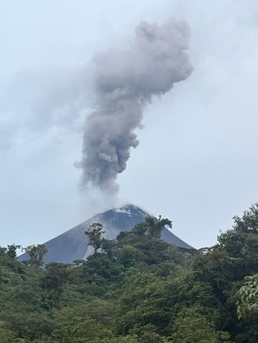
Ecuador , El Reventador :
DAILY STATUS REPORT OF REVENTADOR VOLCANO, Sunday, August 31, 2025.
Information Geophysical Institute – EPN.
Surface Activity Level: High, Surface Trend: No Change
Internal Activity Level: Moderate, Internal Trend: No Change
From August 30, 2025, 11:00 a.m. to August 31, 2025, 11:00 a.m.:
Seismicity:
Below is the count of seismic events recorded at the reference station.
Explosion (EXP) 94
Long Period (LP) 13
Emission Tremor (TREMI) 8
Harmonic Tremor (TRARM) 5
Rainfall/Lahars:
No rainfall has been recorded in the volcanic area. **Heavy rainfall could remobilize accumulated material, generating mud and debris flows that would cascade down the volcano’s flanks and flow into adjacent rivers.
Emissions/Ash Column:
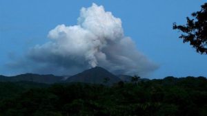
Since yesterday afternoon, surveillance cameras have observed several gas and ash emissions between 500 and 1,300 meters above the crater level, in east-southeast and southwest directions. In this regard, the Washington VAAC has published two emission reports reaching 1,100 meters above the crater level, in northwest and southwest directions.
Other monitoring parameters:
The MIROVA-VIIRS satellite system recorded two thermal anomalies, the MIROVAMODIS satellite system one thermal anomaly, and the FIRMS satellite system 16 thermal anomalies over the past 24 hours.
Observation:
Since last night, the monitoring system has observed several falls of incandescent material reaching up to 1,100 meters below the crater level, along the east-southeast and southeast flanks. In addition, yesterday afternoon, the descent of a pyroclastic flow was observed along the southwest flank. At the time of writing, the volcano remains partially exposed.
Alert Level – SGR: Orange
Source : IGEPN
Photo : archive igepn
Costa Rica , Rincon de la Vieja :
Latitude: 10.83°N;
Longitude: 85.34°W;
Altitude: 1,916 m.
Current activity level: Alert.
This week, two minor eruptions were recorded, one on August 24 and the second on August 25. These events are phreatic and of low amplitude. Tremor is always observed with two distinct sources: one high-frequency and continuous, and the other low-frequency and fragmented (short tremors). This tremor was variable throughout the week. At the beginning of the week, the amplitude was higher and then gradually decreased until August 27, particularly the short tremor pulses.
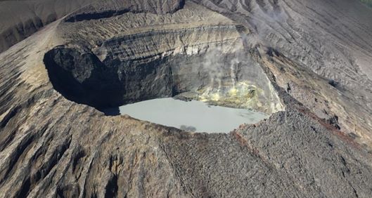
Long-period « tornillos » events and proximal volcano-tectonic (VT) earthquakes have also been recorded. Geodetic observations show subsidence and a southward shift of the summit. The uplift at the base of the volcanic edifice is disappearing. This week, DOAS stations detected an SO2 flux of 140 ± 45 t/d. Furthermore, no traces of SO2 have been recorded in the atmosphere by satellite measurements since August 12.
Source : Ovsicori .
Photo : Chris Allen de Sunquest Helitours
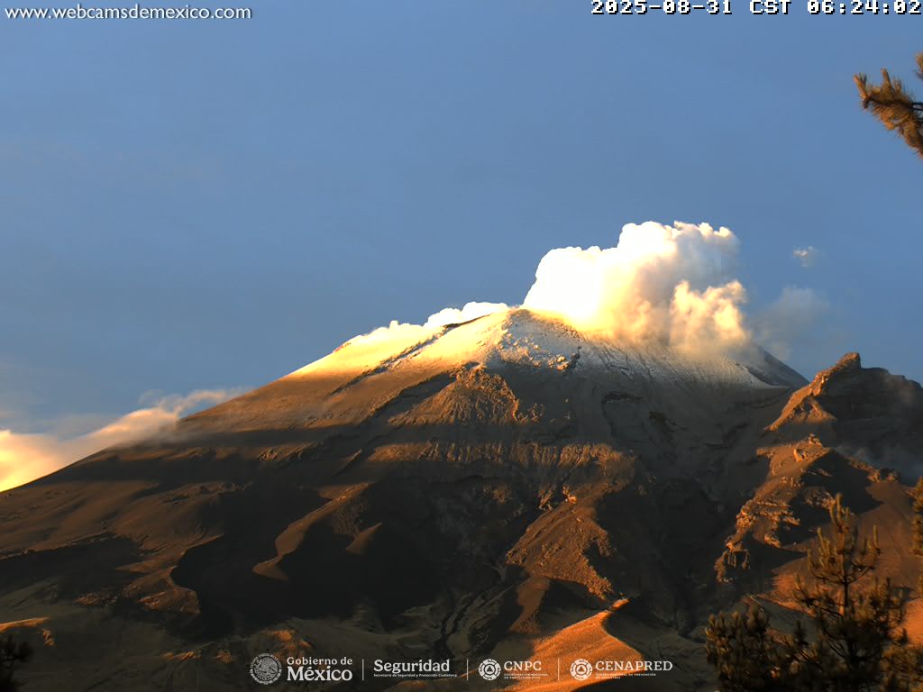
Mexico , Popocatepetl :
August 31, 11:00 a.m. (August 31, 5:00 p.m. GMT), Activity in the last 24 hours
Thirty low-intensity exhalations accompanied by water vapor, volcanic gases, and ash were detected. In addition, 756 minutes of low-amplitude tremor were recorded, including 568 minutes of high-frequency tremor and 188 minutes of harmonic tremor.
Yesterday at 4:44 p.m., a minor explosion was recorded, invisible due to weather conditions.
During the morning and at the time of writing, a steady emission of water vapor and volcanic gases was observed in a westerly direction.
The Popocatépetl volcano fire alert is at yellow phase 2.
The expected scenarios for this phase are as follows:
A few minor to moderate explosions
Occurrence of tremors of varying amplitude
Light to moderate ashfall in surrounding towns and some more distant towns
Expulsion of incandescent fragments within a 12-kilometer exclusion radius
Lahars descending into ravines are expected due to ash accumulation on the slopes and their interaction with the precipitation expected in the coming weeks
Possibility of pyroclastic flows not reaching towns
Source : Cenapred .
Indonesia , Ibu :
VOLCANO OBSERVATORY NOTICE FOR AVIATION – VONA
Issued : August 31 , 2025.
Volcano : Ibu (268030)
Current Aviation Colour Code : ORANGE
Previous Aviation Colour Code : orange
Source : Ibu Volcano Observatory
Notice Number : 2025IBU989
Volcano Location : N 01 deg 29 min 17 sec E 127 deg 37 min 48 sec
Area : North Maluku, Indonesia
Summit Elevation : 4240 FT (1325 M)
Volcanic Activity Summary :
Eruption with volcanic ash cloud at 05h22 UTC (14h22 local).
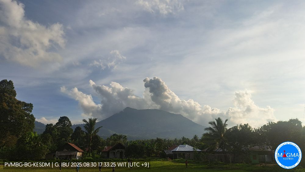
Volcanic Cloud Height :
Best estimate of ash-cloud top is around 6160 FT (1925 M) above sea level or 1920 FT (600 M) above summit. May be higher than what can be observed clearly. Source of height data: ground observer.
Other Volcanic Cloud Information :
Ash cloud moving to northeast. Volcanic ash is observed to be gray. The intensity of volcanic ash is observed to be thick.
Remarks :
Eruption recorded on seismogram with maximum amplitude 28 mm and maximum duration 78 second.
Seismic Observations
107 eruption earthquakes with amplitudes ranging from 16 to 28 mm and durations ranging from 31 to 78 seconds.
27 harmonic tremors with amplitudes ranging from 2 to 28 mm and durations ranging from 26 to 283 seconds.
95 low-frequency earthquakes with amplitudes ranging from 2 to 10 mm and durations ranging from 17 to 29 seconds.
147 shallow volcanic earthquakes with amplitudes ranging from 2 to 11 mm and durations ranging from 7 to 23 seconds.
3 deep volcanic earthquakes with amplitudes ranging from 2 to 6 mm and durations ranging from 18 to 26 seconds.
2 local tectonic earthquakes with amplitudes ranging from 2 to 10 mm and durations ranging from 23 to 42 seconds.
17 distant tectonic earthquakes with amplitudes of 2 to 28 mm, and earthquake duration of 34 to 118 seconds.
Source et photo : Magma Indonésie