September 25 , 2026.
Hawaii , Kilauea :
HAWAIIAN VOLCANO OBSERVATORY DAILY UPDATE , U.S. Geological Survey
Thursday, September 24, 2026, 8:43 AM HST (Thursday, September 24, 2026, 18:43 UTC)
19°25’16 » N 155°17’13 » W,
Summit Elevation 4091 ft (1247 m)
Current Volcano Alert Level: WATCH
Current Aviation Color Code: ORANGE
Summary:
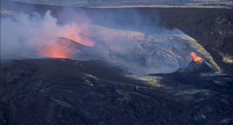
Precursory overflows from the north vent resumed on September 22. Strong glow from all vents continued with intermittent spatter from the north and south vents. There is no anomalous activity outside of the summit.
Overview:
Precursory overflows from the north vent resumed on the night of September 22. Glow and flames continued from the north-south-west vent complex throughout the night, with intermittent spatter bursts from the vents. There are currently no signs of activity at the recent vents 1-6. The summit has inflated slightly over the past 24 hours, and continuous tremor remains the dominant seismic signal across the summit.
No anomalous seismic activity or deformation has occurred outside of the summit region, and no significant activity has been noted along Kīlauea’s East Rift Zone or Southwest Rift Zone.
NOTICE:
Hawaiʻi Volcanoes National Park is issuing temporary parkwide closures at 5 p.m. today September 24 ahead of the arrival of Hurricane Nolo
Summit Observations:
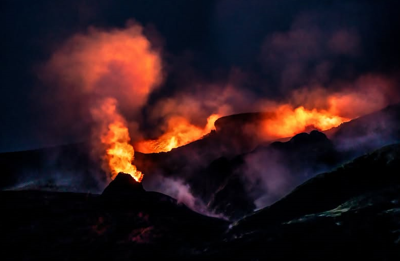
Precursory overflows from the north vent resumed on Tuesday night, September 22, beginning at 10:10 p.m. HST. Since then, there have been 22 overflows from the north vent. Most of the overflows have lasted about 15-35 minutes and produced lava flows that traveled a few hundred meters (yards) from the vent. They were all fed by vigorous fountains that rise 15-30 feet (5-10 meters) above the small 30-50 foot (10-15 meter) cone that has built up at the north vent. The north, south, and west vents continued to glow and emit flames. Intermittent spatter bursts were also observed from all vents last night between overflows. No other areas of incandescence were observed across the summit region last night.
Continuous tremor marked by small tremor pulses is the dominant seismic signal across the summit. There were eight small and shallow earthquakes located across the summit region in the past day, but they did not form clusters in time or location.
Summit tilt has slowly inflated over the past day, with about 0.2 microradians of inflation recorded. The current total inflation since the end of episode 54 is about 15.8 microradians, slightly less than the maximum of 16 microradians reached on September 16 and more than two microradians greater than was lost during episode 54 fountaining.
During inter-episode pauses, the sulfur dioxide (SO2) emission rate from the summit typically varies between 1,000 and 5,000 tonnes per day. Winds are currently from the northeast but may shift in the days ahead as Hurricane Nolo approaches Hawaiʻi Island.
Rift Zone Observations:
Rates of seismicity and ground deformation remain low in the East Rift Zone and Southwest Rift Zone. SO2 emissions from the East Rift Zone remain below the detection limit. No significant ground deformation was recorded in either rift zone.
Source : HVO.
Photos : Hawaii Volcanoes National Park , J Wei / FB.
Italy / Sicily , Etna :
VOLCANO OBSERVATORY NOTICE FOR AVIATION (VONA)
Issued: September 24 , 2026
Volcano: Etna 211060
Current Color Code: RED
Previous Color Code: orange
Source: Etna Volcano Observatory
Notice Number: 2026/0116/07E08
Volcano Location: 3744N 01500E
Area: Italy
Summit Elevation: 3300 m
Volcanic Activity Summary:
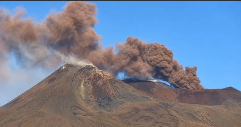
ASH EMISSION ONGOING
Volcanic cloud height:
EXTIMATED VOLCANIC CLOUD HEIGHT IS 4000M AT THE TOP
Other volcanic cloud information:
ASH CLOUD MOVES TOWARD SSE
Remarks:
THE PHENOMENON IS OBSERVED BY VISIBLE AND THERMAL SURVEILLANCE CAMERAS FROM 05:00
Source : INGV.
Photo : Web cam via FB.
La Réunion , Piton de la Fournaise :
Press release from the Institut de physique du globe de Paris / Piton de la Fournaise Volcanological Observatory, September 24, 2026 – 9:00 AM local time – 5:00 AM UTC
Statement regarding increased seismicity
Since September 17, 2026, a slight increase in seismicity beneath the summit area of Piton de la Fournaise has been recorded by the OVPF-IPGP monitoring network. The number of daily earthquakes has risen from 8 on September 17 to over 19 over the past three days.
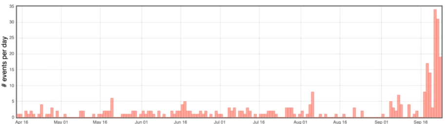
Figure 1: Histogram showing the number of shallow volcano-tectonic earthquakes per day between April 15 and September 23, 2026 (©WebObs/OVPF-IPGP).
This seismicity is currently of very low magnitude (M<1), making precise localization impossible. However, seismic wave arrival times allow them to be located beneath the summit, at the level of the shallow magma reservoir.
This increase in seismicity is occurring against a backdrop of renewed inflation (swelling) of the volcanic edifice, recorded since early August (see OVPF-IPGP monthly bulletin for August 2026). Displacement vectors and the 3D linear strain map indicate an inflation source located beneath the summit of the edifice.
Although primarily consisting of low-magnitude events, this rise in summit seismicity—occurring alongside edifice inflation—nevertheless reflects an acceleration of activity beneath the summit and a buildup of pressure in the shallow reservoir.
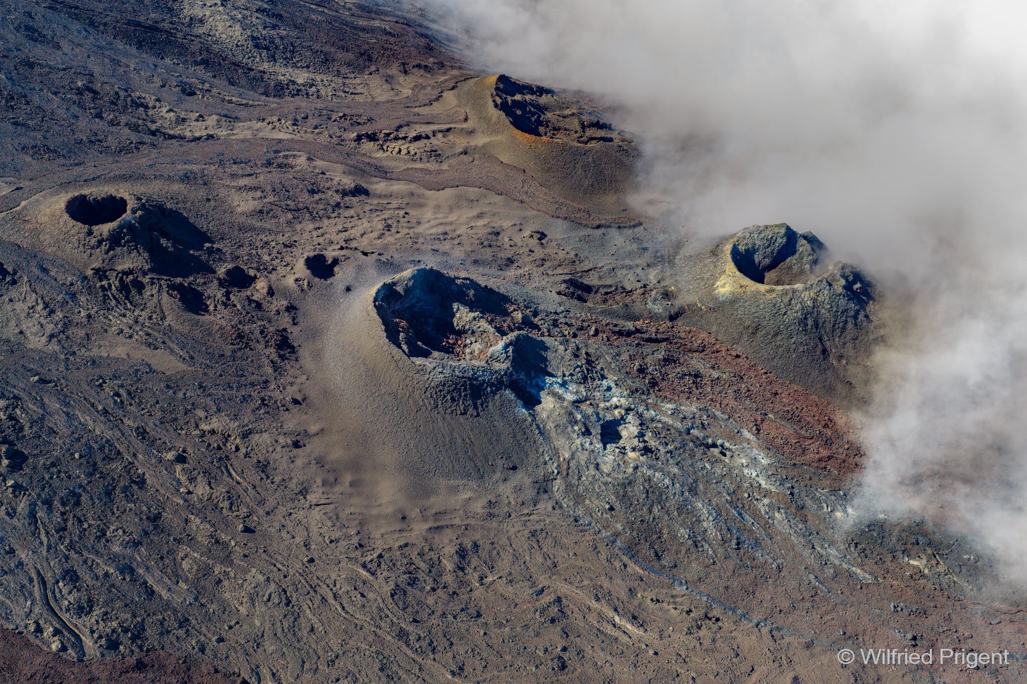
It should be noted that this process of shallow reservoir pressurization can last from several days to several weeks before the reservoir roof ruptures—leading to magma injection toward the surface and potentially an eruption—but it can also cease without resulting in an eruption in the short term.
Source : OVPF.
Photos : OVPF , Wilfried Prigent / ovpf/FB.
Vanuatu , Ambrym :
The Vanuatu Meteorology and Geo-Hazards Department (VMGD) reported that a new eruption at Ambrym likely started on 19 September. An intense thermal anomaly and high sulfur dioxide emissions were identified in satellite data; a volcanic cloud was visible in a satellite image at 06h00. Ground-based observers reported dark gray ash-and-gas plumes rising from Marum Crater and rumbling sounds coming from the crater. Minor ashfall was reported in areas downwind, including in communities to the W, NW, and NNE. Summit incandescence was reported by residents at around 20h00.
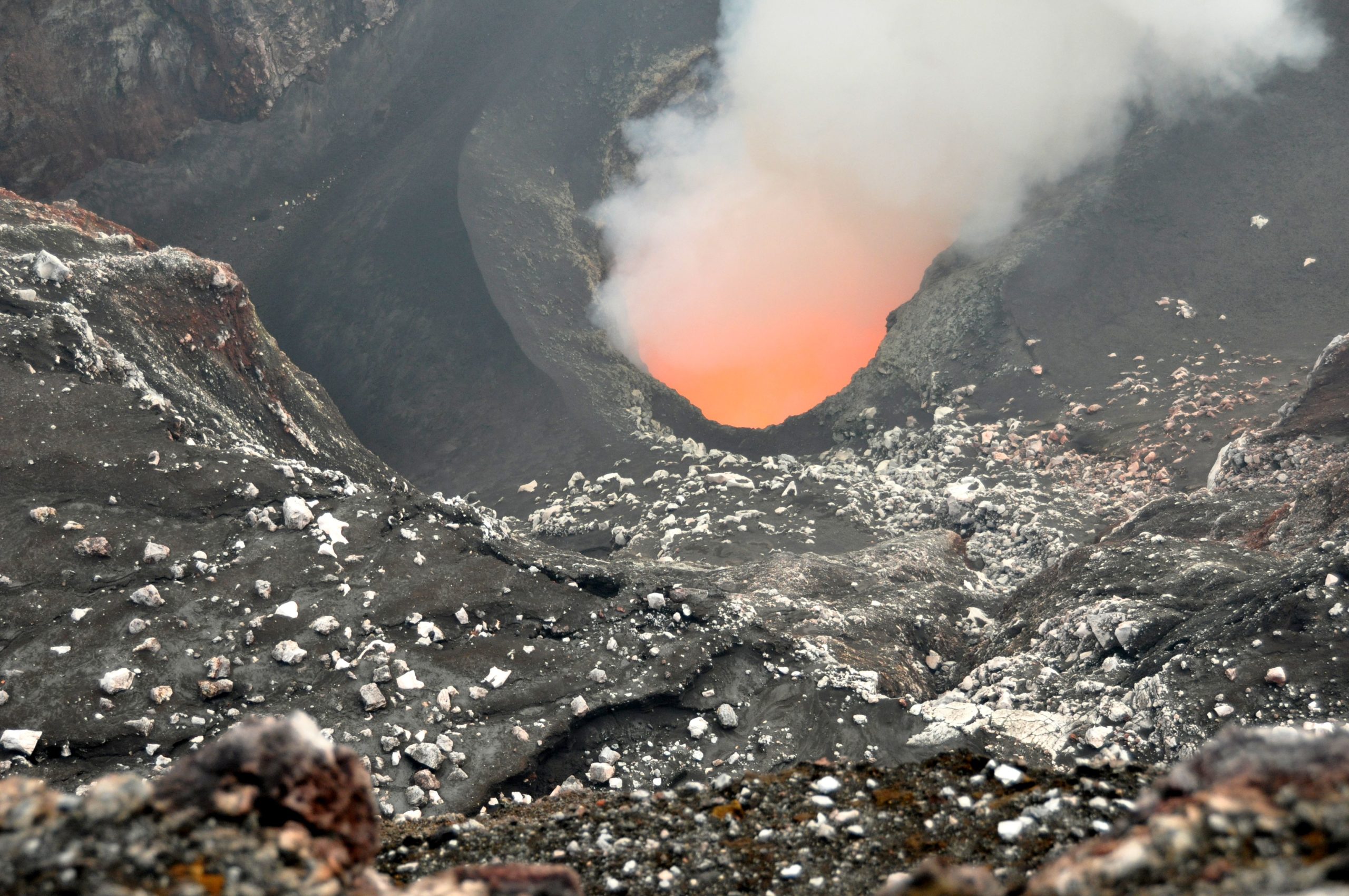
The eruption continued on 20 September. Ash-and-gas plumes were visible in satellite data at 03h50 and lava effusion within the crater was detected at 10h09. Residents continued to hear rumbling and observe crater incandescence. The Alert Level remained at 2 (on a scale of 0-5). VMGD warned the public to stay outside of Permanent Danger Zone A, defined as a 1-km radius around Benbow Crater and a 2-km radius around Marum Crater (including Maben-Mbwelesu, Niri-Mbwelesu, and Mbwelesu craters).
Sources: Vanuatu Meteorology and Geohazards Department (VMGD) , GVP.
Photo : G Vitton ( Bembow)
Japan , Tokachidake :
The Japan Meteorological Agency (JMA) reported that volcanic activity at Tokachidake continued to intensify. Inflation at relatively shallow depths began to be detected in March. Beginning in April there was an increase in sulfur dioxide emissions, a higher frequency of diffuse volcanic emissions and crater glow observed in monitoring cameras, and slightly elevated seismic activity near and around 62-2 Crater.
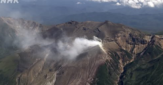
in May volcanic plumes became more frequent and emissions at the Furikozawa fumarole group rose higher. Subsequently, very small-scale eruptions occurred near the 62-2 Crater on 22 July, 5 August, and 6 August. Additionally, there was an increase in large-amplitude volcanic earthquakes originating near the edifice; two occurred on 12 September, bringing the total count over the preceding 30 days to five. At 09h30 on 12 September the Alert Level was raised to 3 (on a scale of 1-5) and the public was warned to be cautious within a 3 km radius.
Sources: Japan Meteorological Agency (JMA) , GVP.
Photo : NHR.