October 5 , 2026.
Kamchatka , Sheveluch :
KVERT VOLCANIC ACTIVITY NOTICE (VAN)
Issued: October 5 , 2026
Volcano: Sheveluch (CAVW #300270)
Current aviation colour code: ORANGE
Previous aviation colour code: orange
Source: KVERT
Notice Number: 2026-103
Volcano Location: N 56 deg 38 min E 161 deg 19 min
Area: Kamchatka, Russia
Summit Elevation: 3283 m (10768.24 ft), the dome elevation ~2500 m (8200 ft)
Volcanic Activity Summary:
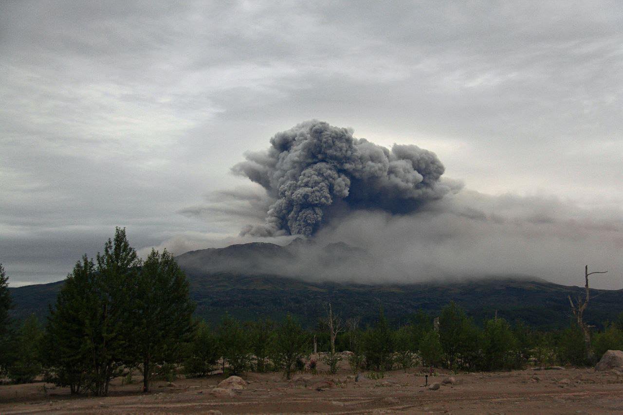
An explosive-extrusive eruption of the volcano continues, accompanied by powerful gas-steam activity; a new block of lava continues to grow in the northern part of the lava dome. Explosion sent ash up to 6.5 km a.s.l, ash cloud moved 20 km to north-east of the volcano.
An explosive-extrusive eruption of the volcano continues. Ash explosions up to 12 km (39,400 ft) a.s.l. could occur at any time. Ongoing activity could affect international and low-flying aircraft.
Volcanic cloud height:
6500 m (21320 ft) AMSL Time and method of ash plume/cloud height determination: 20261004/2240Z – Video data
Other volcanic cloud information:
Distance of ash plume/cloud of the volcano: 20 km (12 mi)
Direction of drift of ash plume/cloud of the volcano: NE
Time and method of ash plume/cloud determination: 20261004/2240Z – Himawari-9 14m15
Start time of explosion and how determined: 20261004/2240Z – Video data
Duration of explosion: ~ 5 min
Source : Kvert .
Photo : Viktor Frolov , Institut de volcanologie et de sismologie DVO RAN, @IViS_DVO_RAN
Indonesia , Ili Lewotolok :
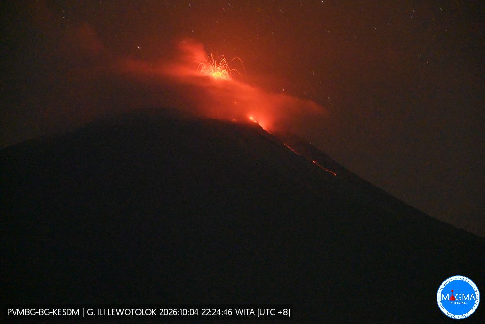
An eruption of Mount Ili Lewotolok occurred on Saturday, October 3, 2026, at 08:50 WITA, with an ash column reaching a height of approximately 600 m above the summit (i.e., ±2,023 m above sea level). This column, of moderate intensity and white to gray in color, drifted westward. The eruption was recorded by the seismograph with a maximum amplitude of 19.5 mm and a duration of 45 seconds.
Seismic observations
75 eruption earthquakes, with amplitudes of 19.5–40 mm and durations of 28–100 seconds.
158 emission earthquakes, with amplitudes of 3.9–19.5 mm and durations of 29–60 seconds.
2 distant tectonic earthquakes, with amplitudes of 9.7–40 mm and durations of 190–367 seconds.
Recommendations
1. Communities near Mount Ili Lewotolok, as well as visitors, climbers, and tourists, must not enter or conduct activities within a 2 km radius—extending to 3 km in the south and southeast sectors—of the Mount Ili Lewotolok activity center.
2. Remain vigilant regarding potential hazards associated with lava avalanches/rockfalls and pyroclastic flows in the south, southeast, west, and northeast sectors of Mount Ili Lewotolok.
Source et photo : PVMBG.
Alaska , Gareloi :
No additional signs of unrest have been detected following the short‑duration explosion on October 1. Over the past day, wind noise has limited detection of seismic and infrasound signals, and cloud cover has obscured satellite views of the volcano.
Gareloi volcano persistently emits magmatic gases from a fumarole field on the south crater and commonly exhibits low-level seismic activity. These observations suggest the presence of shallow magma and potential interaction with a hydrothermal system.
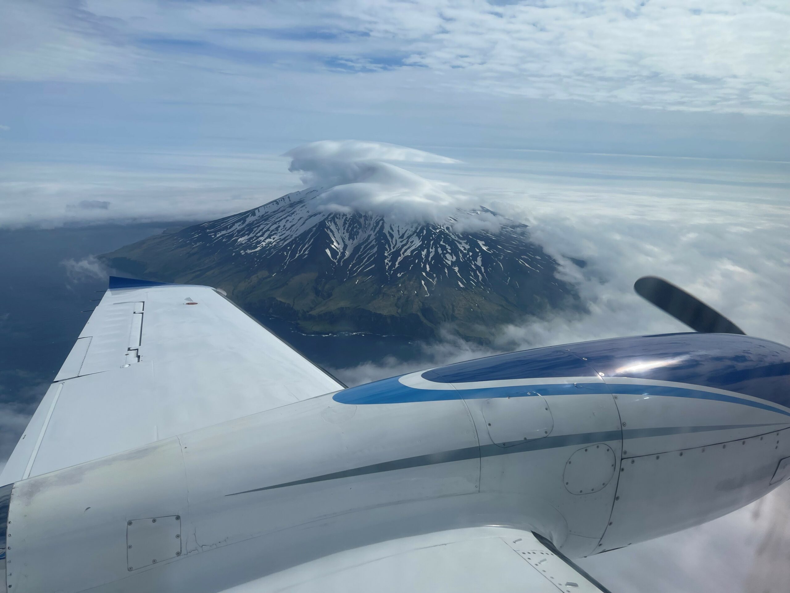
This October 1 explosion likely reflects a change to the magmatic-hydrothermal system, but it is not clear that the likelihood of a volcanic eruption has increased. AVO will continue to monitor activity to determine if the recent changes are related to influx of new magma or other changes to the magma system.
Mount Gareloi is monitored by a local seismic and infrasound network, satellite data, and regional infrasound and lightning-detection networks.
Source : AVO.
Photo : Karri Sicard.
Guatemala , Santiaguito :
Weather conditions: Cloudy
Wind: Southeast
Precipitation: 66.3 mm
Activity
The Santiaguito Volcano Observatory reports conditions unfavorable for observing the dome due to cloud cover. Weak to moderate explosions are being recorded at a rate of 1 to 3 per hour, propelling gas and ash plumes up to 800 meters in altitude. These plumes are drifting northwestward with the wind.
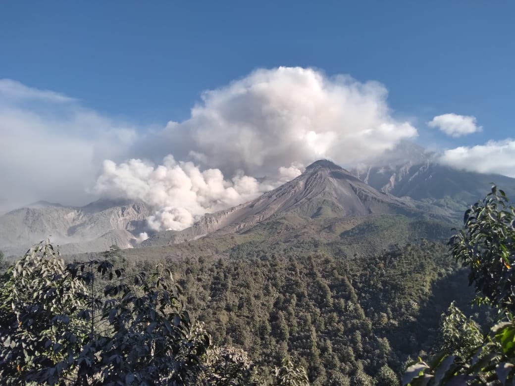
Incandescence is visible at the dome, along with the detachment of incandescent rock blocks toward the west, southwest, and south flanks. Ashfall is possible over Santa Ines, Tuibul, and surrounding areas due to wind direction. Given the significant accumulation of rock material, the « Domo Caliente » (Hot Dome) and the promontory above the lava flow could collapse, generating long-range pyroclastic density currents toward the southwest; the recommendations in special bulletin BESAN-016-2026 should therefore be followed.
Source et photo : Insivumeh
Hawaii , Kilauea :
HAWAIIAN VOLCANO OBSERVATORY DAILY UPDATE , U.S. Geological Survey
Sunday, October 4, 2026, 8:30 AM HST (Sunday, October 4, 2026, 18:30 UTC)
19°25’16 » N 155°17’13 » W,
Summit Elevation 4091 ft (1247 m)
Current Volcano Alert Level: WATCH
Current Aviation Color Code: ORANGE
Summary:
No overflows or spattering at north or south vents over the past day; strong glow and flames continue. No reactivation of Sept. 30–Oct. 1 intrusion. Earthquake activity continues underneath Halemaʻumaʻu. No anomalous activity outside the summit.
Overview:
There have been no overflows or spatter from north or vents in the past 24 hours, although there was strong glow and flames from the vents overnight. The summit intrusion that happened the night of September 30 to October 1 has not reactivated, although earthquake activity has continued underneath Halemaʻumaʻu and summit tiltmeters recorded minor inflation.
Episode 55 fountaining remains a possibility during the ongoing Kīlauea summit eruption. It is also possible that intrusive activity below Kīlauea summit caldera could resume and potentially lead to the eruption of lava in a new location within the caldera.
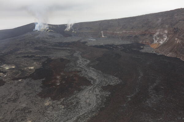
Aerial view of the northern part of the crater floor of Halemaʻumaʻu at the summit of Kīlauea taken during a USGS monitoring overflight on the morning of October 1, 2026. Black rubbly ʻaʻā and smooth gray pāhoehoe lava flows are visible emanating from the vent complex that is visible the left background of the photo.
Summit Observations:
In the past 24 hours, there have been no overflows and no spattering. Both vents had strong glow with flaming overnight. No other areas of incandescence were observed across the summit region last night. An intrusion underneath Kaluapele, the Kīlauea summit caldera, started the afternoon of September 30 and ended on October 1 at around 4 a.m. H.S.T. South vent only had one overflow after the intrusion, ending just before 6 a.m. on October 1, and north vent’s last overflow was also on October 1, just after 6 a.m. H.S.T.
Elevated rates of earthquakes below Kaluapele continue following the intrusion. In the past 24 hours, there were 9 shallow earthquakes located across the summit region, primarily underneath Halemaʻumaʻu, and the Uēkahuna tiltmeter (UWD) recorded approximately 0.7 microradians of inflation.
During inter-episode pauses, the sulfur dioxide (SO2) emission rate from the summit typically varies between 1,000 and 5,000 tonnes per day. Winds are currently forecast from the north northeast.
Rift Zone Observations:
Rates of seismicity and ground deformation remain low in the East Rift Zone and Southwest Rift Zone. SO2 emissions from the East Rift Zone remain below the detection limit. No significant ground deformation was recorded in either rift zone.
Source : HVO
Photo : USGS / D. Downs