November 13 , 2026.
Philippines , Mayon :
The Philippine Institute of Volcanology and Seismology (PHIVOLCS) reported elevated activity at Mayon during 28 October-4 November. Sulfur dioxide emissions averaged 1,413-3,360 tonnes per day. Moderate emissions generally rose 100 m above the summit and drifted SW, WSW, and WNW.
The seismic network recorded 35 and 101 daily volcanic earthquakes on 28 and 29 October, respectively, including 5-18 daily periods of volcanic tremor lasting 1-9 min. A moderately explosive eruption during 11h53-11h59 on 30 October generated a dense, billowing ash plume that rapidly rose 3 km above the summit and drifted WSW.
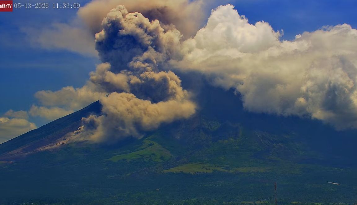
The Alert Level remained was raised to 3 (on a 0-5 scale) and the public was reminded to stay away from the 6-km-radius Permanent Danger Zone (PDZ). Ashfall was most notable in municipality of Guinobatan. According to the Philippine Red Cross and Civil Defense Bicol authorities evacuated 205 families from barangays Anoling and Quirangay in Camalig, within the PDZ.
There were 11-14 daily volcanic earthquakes recorded by the seismic network during 31 October-3 November, seven rockfall signals on 31 October, and one rockfall signal each day during 1-2 November. On 31 October an ash emission lasting 53 seconds was detected by the seismic network. In general, emissions that day rose as high as 200 m above the summit and drifted W. Minor Strombolian activity was visible on 2 November. At 08h22 on 3 November minor Strombolian activity generated an ash plume that rose 1.6 km above the summit and drifted SW.
Sources: Philippine Institute of Volcanology and Seismology (PHIVOLCS), Philippine Red Cross, The National Disaster Risk Reduction and Management Council (NDRRMC) , GVP.
Photo : Afar tv.
Hawaii , Kilauea :
HAWAIIAN VOLCANO OBSERVATORY DAILY UPDATE , U.S. Geological Survey
Thursday, November 12, 2026, 8:32 AM HST (Thursday, November 12, 2026, 18:32 UTC)
19°25’16 » N 155°17’13 » W,
Summit Elevation 4091 ft (1247 m)
Current Volcano Alert Level: ADVISORY
Current Aviation Color Code: YELLOW
Summary:
The Halema’uma’u eruption of Kīlauea remains paused following episode 56 fountaining on November 5. The summit is reinflating and the episode 57 forecast window is November 16-21.
Overview:
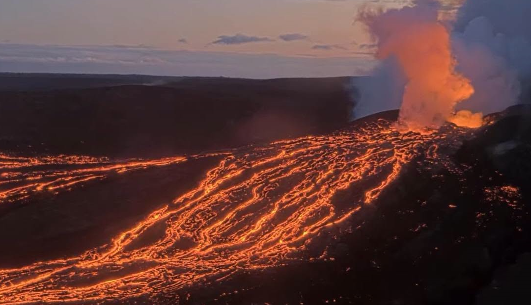
The Kīlauea summit eruption within Halema’uma’u is currently paused after episode 56 fountaining ended on November 5. The summit has been steadily reinflating since the end of episode 56 and another fountaining episode remains likely. The current forecast window for episode 57 fountaining is November 16-21.
Summit Observations:
Summit webcams recorded moderate to strong glow from the southwest vent and intermittent glow from the north vent overnight. During a helicopter overflight on November 10, USGS Hawaiian Volcano Observatory Scientists observed a roiling lava surface in both vents about 130-165 feet (40-50 meters) deep.
Seismic tremor remains elevated during the eruption pause. One small earthquake was located at the summit in the past day.
The Uēkahuna tiltmeter (UWD) has recorded continued summit inflation following the end of episode 56 lava fountaining. This morning, UWD has recovered a total of about 10.6 microradians of inflationary tilt since the end of episode 56.
During the eruptive pauses between fountaining episodes, the sulfur dioxide (SO2) emission rate from the summit is typically several thousand tonnes per day. Trade winds this morning are carrying volcanic gases to the southwest.
Rift Zone Observations:
Rates of seismicity and ground deformation remain low in the East Rift Zone and Southwest Rift Zone. SO2 emissions from the East Rift Zone remain below the detection limit.
Source : HVO.
Photo : USGS
Japan , Sakurajima :
The Japan Meteorological Agency (JMA) reported ongoing eruptive activity at Minamidake Crater (Aira Caldera’s Sakurajima volcano) during 19-26 October. A total of 31 eruptive events and two explosions produced ash plumes that generally rose as high as 2.2 km above the crater. Large blocks were also ejected as far as 500 m from the vent during 26-30 October. Volcanologists conducted a field survey on 27 October and measured high sulfur dioxide emissions, averaging 2,100 tons per day. An explosion at 1949 on 30 October generated an ash plume that rose 3 km above the crater rim and ejected large blocks 800 above the rim. The Alert Level remained at 3 (on a 5-level scale), and the public was warned to be cautious within 1 km of both the Minimadake and Showa craters.
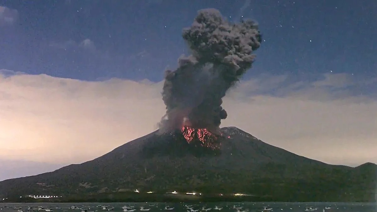
The Aira caldera in the northern half of Kagoshima Bay contains the post-caldera Sakurajima volcano, one of Japan’s most active. Eruption of the voluminous Ito pyroclastic flow accompanied formation of the 17 x 23 km caldera about 22,000 years ago. The smaller Wakamiko caldera was formed during the early Holocene in the NE corner of the caldera, along with several post-caldera cones. The construction of Sakurajima began about 13,000 years ago on the southern rim and built an island that was joined to the Osumi Peninsula during the major explosive and effusive eruption of 1914. Activity at the Kitadake summit cone ended about 4,850 years ago, after which eruptions took place at Minamidake. Frequent eruptions since the 8th century have deposited ash on the city of Kagoshima, located across Kagoshima Bay only 8 km from the summit. The largest recorded eruption took place during 1471-76.
Sources: Japan Meteorological Agency (JMA) , GVP.
Photo : JMA.
Indonesia , Semeru :
Eruption with volcanic ash cloud at 23h35 UTC (0635 local) on 12/11/2026 . Best estimate of ash-cloud top is around 13363 FT (4176 M) above sea level or 1600 FT (500 M) above summit. May be higher than what can be observed clearly. Source of height data: ground observer. Ash cloud moving to southwest. Volcanic ash is observed to be gray. The intensity of volcanic ash is observed to be thick..
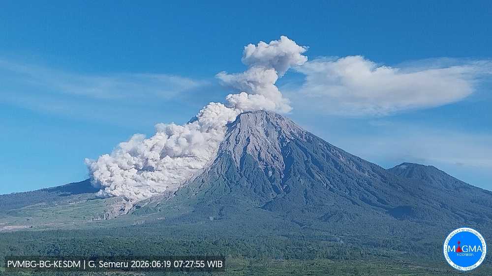
The Pusat Vulkanologi dan Mitigasi Bencana Geologi (PVMBG) reported that activity continued at Semeru during 29 October-4 November, with daily eruptive events recorded by the seismic network. White-to-gray or gray ash plumes rose 300-800 m above the summit and drifted SW and W during 29-30 October and 2-3 November; emissions were not visible due to weather conditions on the other days. According to news articles a lahar that lasted nearly four hours on 30 October descended the SE drainage. Lahars that lasted six hours on 2 November descended drainages on the SE flank. A 200-m-long section of the Glidik River embankment collapsed near Purorejo Village, damaging three houses and cutting off the road to Taman Sari hamlet, isolating 117 families. Damage to infrastructure being built to channel lava flows was also reported. A pyroclastic flow was detected on 3 November but not visually confirmed due to weather conditions. The Alert Level remained at 3 (the second highest level on a scale of 1-4) and the public was warned to stay at least 5 km away from the Jonggring Saloko Crater in all directions, 13 km from the summit on the SE flank along the Kobokan drainage, and 500 m from the banks of the Kobokan drainage as far as 17 km SE of the summit.
Sources: Pusat Vulkanologi dan Mitigasi Bencana Geologi (PVMBG, also known as CVGHM), Antara News, Antara News, Antara News, Antara News , GVP.
Photo : PVMBG ( archive).
Colombia , Puracé – Los Coconucos volcanic chain :
Popayán, November 10, 2026, 4:00 PM
As part of the ongoing monitoring of the Puracé volcano—part of the Los Coconucos volcanic chain (CVLC)—the Colombian Geological Service (SGC), an agency under the Ministry of Mines and Energy, reports the following:
During the week of November 3 to 9, 2026, seismicity associated with fluid movement (gases and liquids originating from magma and their interaction with the hydrothermal system) remained at levels comparable to those recorded the previous week, in terms of both the number of events and their energy content. These events continued to be localized beneath the Puracé and Piocollo volcanoes, at depths of less than 3 km.
Seismicity associated with rock fracturing (VT events) was concentrated primarily in two areas. The first was located northeast of the Puracé volcano, at distances of 12–18 km and depths of 7–11 km, with a maximum magnitude of 2.0. The second was situated in the zone between the Puracé and Piocollo volcanoes, where low-magnitude events were recorded at depths of 1–3 km. To a lesser extent, events were also detected southeast of the Puracé volcano, at distances of 4–6 km and depths of 5–6 km, with a maximum magnitude of 1.3.
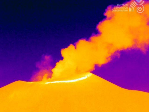
Gas emission at the Puracé volcano, November 5, 2026, at 02:21. Recording captured by the Mina thermal camera, located 2.2 km northwest of the Puracé volcano.
A process of slow ground deformation continues in the area between the Puracé, Piocollo, and Curiquinga volcanoes. Furthermore, significant levels of sulfur dioxide (SO₂) and carbon dioxide (CO₂) emissions into the atmosphere continue to be recorded. Satellite observations have identified low-energy thermal anomalies within the crater of the Puracé volcano during this period.
In addition, continuous degassing has been recorded, along with 17 ash emissions; some of these reached altitudes of up to 1.3 km above the summit of the Puracé volcano, with dispersion primarily directed toward the northwest.
In conclusion, the variations observed at the Puracé volcano indicate that the system remains unstable across several monitored parameters. Further ash emissions and fallout are possible, with dispersion determined by the prevailing wind direction. Likewise, the occurrence of additional changes in volcanic activity—potentially leading to higher-energy surface manifestations—cannot be ruled out.
The alert level for volcanic activity remains at « Yellow, » indicating an active volcano showing changes in the baseline behavior of monitored parameters, among other manifestations.
Source et photo : SGC.