March 25 , 2026.
La Réunion Island , Piton de la Fournaise :
Press release from the Paris Institute of Earth Physics / Piton de la Fournaise Volcanological Observatory, March 25, 2026 – 8:40 a.m. local time – 4:40 a.m. UTC
Ongoing eruption
Summary
The eruption that began on February 13, 2026, continues. Only one eruptive site remains active on the south-southeast flank. Only the main southern flow is still being fed and continues to supply a platform to the ocean, on which lava flows are now primarily channeled. Active eddies and recurring overflows are observed at the eruptive cone. Seismicity and surface deflation show a slowdown. Eruptive tremor (an indicator of lava and gas flow) is relatively stable but shows numerous low-amplitude fluctuations.
Observations at the various sites
The eruption that began on February 13, 2026, shortly after 10:00 AM (local time) at Piton de la Fournaise continues.
Only one eruptive site remains active on the south-southeast flank of the volcano at an altitude of 2,056 meters, with a cone formed by the accumulation of ejected material, visible from Piton de Bert. On March 24, the lava level at the cone remained very high, with active eddies and recurring overflows associated with the rising of gas bubbles.
The lava field forms two main arms, each dividing into secondary arms. Over the past 24 hours, only the southern main arm has been active. The fronts of the two northern arms have remained stable, located at approximately 660 meters altitude for the northern main arm and 690 meters for the northern secondary arm.
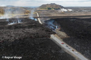
The southern arm, after splitting into several secondary branches, crossed the RN2 highway on March 13 and reached the ocean on March 16.
Several secondary branches also formed downstream of the RN2 before the lava flow reached the ocean. One of these branches eventually reached the sea a few days after the main arm.
At the point of contact between the lava and the ocean, a platform continues to form and expand, resulting from the accumulation of lava flow and fine particles from lava fragmentation. Field measurements taken on the morning of March 24 indicated a platform area of 8.4 hectares and an extension of 193 meters into the ocean.
The platform is now primarily fed by the numerous lava tubes that have developed within it. Lava springs are occasionally visible on the platform’s surface, with lava mainly emerging only at the point of contact with the ocean. Small collapses have been observed along the platform’s edge, caused by wave action.
At the point where the lava enters the ocean, a gas plume is still present. This plume is primarily composed of water vapor, hydrochloric acid (HCl), and fine particles. When lava, at a temperature of approximately 1130°C, comes into contact with ocean water rich in sodium chloride, it generates an acidic aerosol in the form of fine suspended droplets. This plume also contains particles of pulverized lava and fragments of volcanic glass, which can be carried hundreds of meters to kilometers by the wind.
Furthermore, the sudden contact between the lava and the water can generate localized explosions, projecting molten material and jets of high-temperature steam in the immediate vicinity of the point of entry into the sea. Explosions could also occur if the platform becomes destabilized. Indeed, this platform, composed of an accumulation of lava flows and rock fragments, remains very unstable and fragile. In the event of sudden destabilization, explosions of varying intensity could occur.
Instrumental Observations
Seismicity beneath the summit has increased again since yesterday, with 43 earthquakes detected on March 24. This activity remains at a lower level than that observed during the summit deflation from March 19 to 22. The deflation observed at GNSS stations shows a marked slowdown. This trend will need to be confirmed in the coming days.

Evolution of tremor amplitude (an indicator of lava and gas emissions at the surface) between February 13 and March 25, 2026, at the FOR seismological station located near the eruption site. The inset in the upper right shows a zoom on the last 24 hours (©WebObs/OVPF-IPGP).
A rise in tremor intensity was recorded yesterday between 11:00 AM and 1:00 PM local time, reaching a level comparable to that observed on March 22. Generally, over the last 48 hours, tremor has been relatively stable but has shown numerous low-amplitude fluctuations. These rapid variations are probably linked to variations in degassing.
Due to significant cloud cover over a large part of the volcano over the last 48 hours, no reliable satellite measurements of lava flow rates could be taken.
Summary
Observations at the various sites
– Eruptive site: active backflow and recurring overflows.
– Lava flows in the Grandes Pentes: only the southern arm was active in the last 24 hours.
– Platform: well-developed lava tunnel activity, with lava mainly emerging only at the point of contact with the ocean or at a few resurgences. Small collapses were observed along the edge of the platform due to wave action.
Instrumental observations
– 43 earthquakes on June 24th.
– Significant slowdown in deflation. To be confirmed in the coming days.
– Stable tremor with low amplitude fluctuations.
Alert Level 2.2
Source : OVPF / IPGP.
Photos : Luc Perrot photographies / FB , OVPF.
Italy , Stromboli :
WEEKLY BULLETIN, March 16, 2026 to March 22, 2026. (Issuance date: March 24, 2026)
ACTIVITY SUMMARY
Based on monitoring data, the following points should be noted:
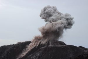
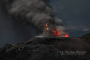
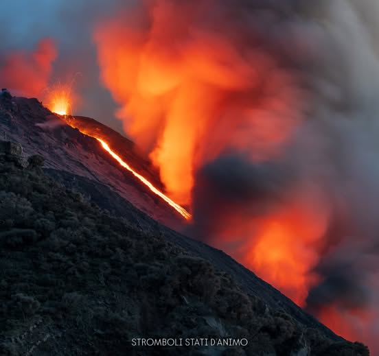
1) VOLCANOLOGICAL OBSERVATIONS: During this period, ordinary Strombolian-type eruptive activity was observed, interrupted by ejecta and two lava overflows from the North Crater area. The total hourly frequency fluctuated between high values (16 and 22 events/hour). The intensity of the explosions was mostly low to medium in the North and Central-South Crater areas.
2) SEISMOLOGY: Monitored seismic parameters show no significant changes, with the exception of two earthquakes of local magnitude 1.0 or greater, which occurred on March 17 at 20:23 UTC (M1=1.0) and 22:03 UTC (M1=1.1), respectively.
3) GROUND DEFORMATION: Signals recorded by the GNSS network show no significant changes. The tilt network is out of service.
4) GEOCHEMISTRY: SO2 flux at an average level.
CO2 flux from the ground in the Pizzo area (STR02) at high values.
C/S ratio in the pen: at average values.
Dissolved helium isotope ratio (R/Ra) in the thermal aquifer: Data from the last sampling, carried out on February 26, 2026, were high (R/Ra = 4.49). The soil CO2 flux in the San Bartolo area was high to medium-high.
The CO2 flux from STR01 was medium.
5) SATELLITE OBSERVATIONS: Satellite-observed thermal activity in the summit area was generally low, with moderate thermal anomalies corresponding to the eruptive events of March 18, 20, and 22, 2026.
VOLCANOLOGICAL OBSERVATIONS:
During the observation period, Stromboli’s eruptive activity was characterized by analyzing images recorded by the INGV-OE monitoring cameras located at 190 m (SCT-SCV) and at Punta dei Corvi (SPCT). The explosive activity was primarily due to five eruptive vents located in the northern zone of the crater and at least two vents located in the central-southern zone.
Due to adverse weather conditions on March 16 and 17, visibility from the crater terrace was insufficient for a precise description of the eruptive activity.
On March 18 and 22, two lava flows were observed in the northern zone of the crater.
Observations of explosive activity captured by surveillance cameras
In the North Crater (N) area, five active vents were observed: two in sector N1 and three in sector N2. These vents produced explosive activity ranging from low (less than 80 m high) to medium intensity (less than 150 m high). In addition, weak but continuous ejection activity was observed at the vents in sector N2.
This activity was particularly intense on the evening of March 18. The eruptive products were primarily coarse material (bombs and lapilli). The average frequency of explosions ranged from 15 to 20 events per hour.
In the Central-South Crater (CS) area, two main vents were observed. These vents produced explosions of fine material mixed with coarse material, ranging from low to medium intensity. The average frequency of explosions varied between less than one event per hour and four events per hour.
Lava overflows of March 18 and 22, 2026.
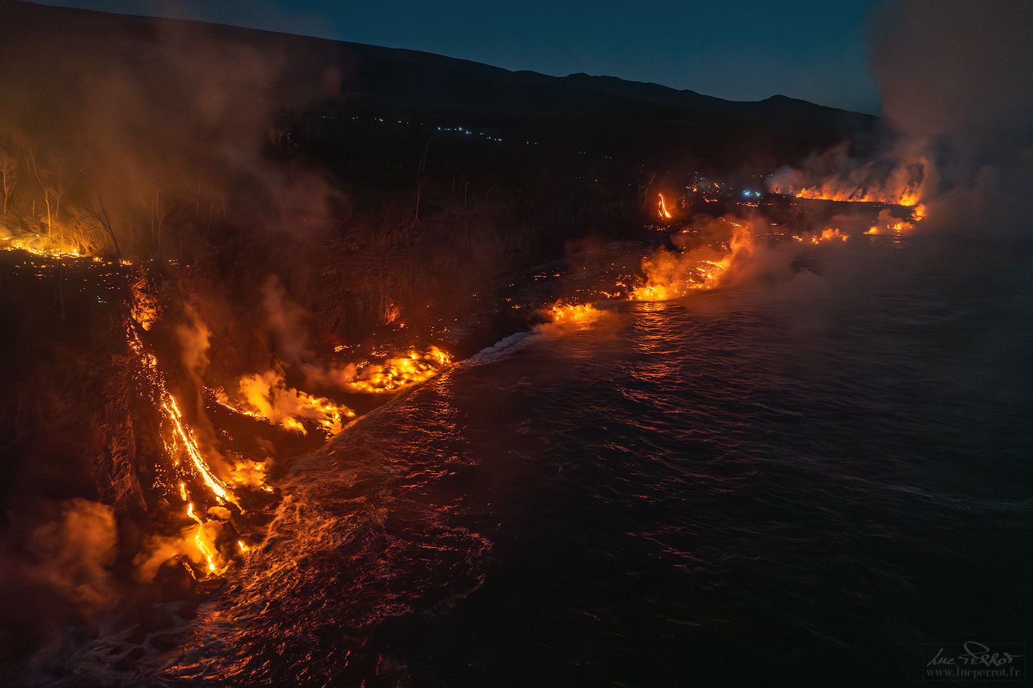
On March 18 and 22, two lava overflows occurred from the South vent of the North Crater, in sector N2, overlooking the Sciara del Fuoco.
On March 18, due to cloud cover, it was not possible to determine the exact start of the lava overflow. However, initial images showed that around 00:55 UTC, large blocks of incandescent material began rolling down the upper part of the Sciara del Fuoco. The lava flow extended down the upper part of the Sciara and, around 11:00 UTC, appeared to be slowly fed and cooling. On March 22, at approximately 5:30 UTC, the second lava flow began, pouring into the canyon carved out in October 2023 and therefore now invisible in surveillance camera footage. The lava flow extended to the upper-middle section of the Sciara and appeared to be cooling around 2:00 UTC on March 23.
Source : INGV
Photo : Stromboli stati d’animo / Sebastiano Cannavo
Indonesia , Ibu :
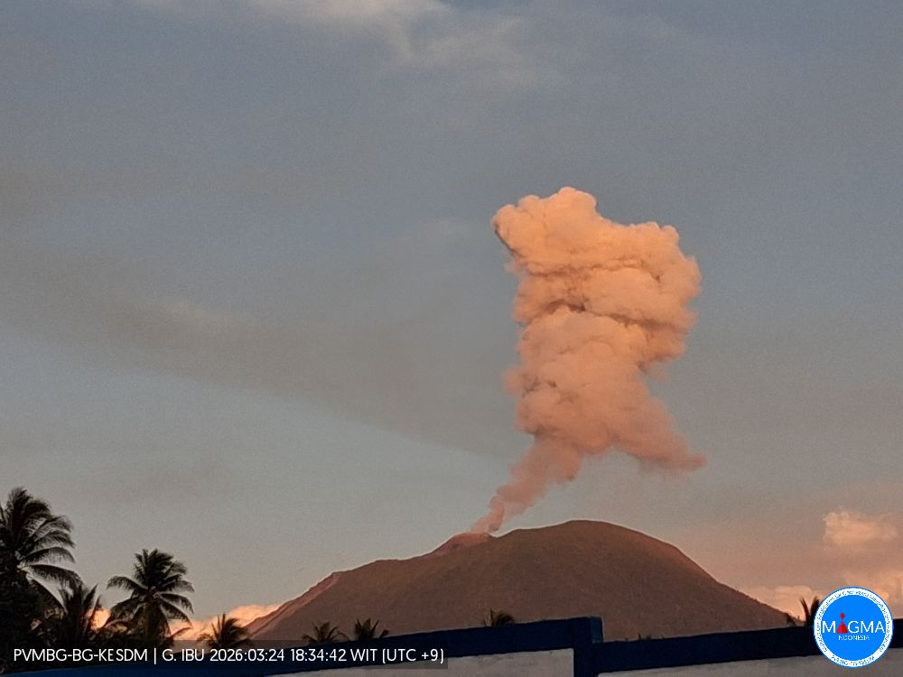
Mount Ibu experienced an eruption on Wednesday, March 25, 2026 at 1:40 p.m. (local time). An ash column was observed approximately 500 meters above the summit (at an altitude of about 1,825 meters). This column was white and of moderate to strong intensity, directed towards the south and southwest. At the time of writing, the eruption was still ongoing.
Seismic Observations
101 eruption earthquakes with amplitudes of 10-28 mm and durations of 35-67 seconds.
3 emission earthquakes with amplitudes of 3-5 mm and durations of 34-46 seconds.
12 harmonic tremors with amplitudes of 3-20 mm and durations of 58-128 seconds.
99 low-frequency earthquakes with amplitudes of 2-10 mm and durations of 17-29 seconds.
127 shallow volcanic earthquakes with amplitudes of 2-6 mm and durations of 7-21 seconds.
2 local tectonic earthquakes with amplitudes of 10-20 mm and durations of 41-97 seconds.
Three distant tectonic earthquakes with amplitudes of 2 mm and durations of 54-87 seconds.
Recommendations
1. Residents living around Mount Ibu and visitors/tourists are advised to refrain from all activities within a 2 km radius and a 3.5 km sector extension towards the crater opening in the northern part of the active Mount Ibu crater.
2. In the event of ashfall, people engaging in outdoor activities are advised to wear a mask covering their nose, mouth, and eyes, as well as protective eyewear.
Source et photo : PVMBG.
Colombia , Chiles / Cerro Negro :
San Juan de Pasto, March 24, 2026, 4:10 PM
Regarding the monitoring of activity at the Chiles-Cerro Negro Volcanic Complex (CVCCN), the Colombian Geological Survey (SGC), an agency under the Ministry of Mines and Energy, reports the following:
During the period from March 17 to 23, 2026, the main variations in monitored parameters compared to the previous week were as follows:
● As part of the fluctuating behavior characteristic of the volcanic complex, an increase in the daily frequency and energy released was recorded.
Seismicity due to rock fracturing predominated, followed by signals related to fluid dynamics in the volcanic conduits.
● The events were concentrated primarily south and southwest of Chiles Volcano, within a 3 km radius and at depths ranging from 0.1 to 10 km from the summit (4,700 m altitude). The strongest earthquake reached a magnitude of 3.1 at a depth of 3.7 km. No earthquakes were felt.
● Data collected by satellite sensors and ground stations continue to record surface variations consistent with deformation processes in certain areas of the volcanic zone of influence.
Based on the assessment and correlation of monitored parameters, the Geological Survey of Colombia (SGC) recommends closely monitoring the evolving situation through weekly bulletins and other information published via its official channels, as well as following instructions from local and departmental authorities and the National Disaster Risk Management Unit (UNGRD).
● Volcanic activity remains at the yellow alert level: Active volcano with changes in the reference behavior of monitored parameters and other manifestations.
Source et photo : SGC.
Hawaii , Kilauea :
HAWAIIAN VOLCANO OBSERVATORY DAILY UPDATE , U.S. Geological Survey
Tuesday, March 24, 2026, 9:02 AM HST (Tuesday, March 24, 2026, 19:02 UTC)
19°25’16 » N 155°17’13 » W,
Summit Elevation 4091 ft (1247 m)
Current Volcano Alert Level: WATCH
Current Aviation Color Code: ORANGE
Activity Summary:
The Halemaʻumaʻu eruption of Kīlauea is paused. The summit is currently inflating slowly; overnight, occasional glow was visible from the south vent and gas-pistoning continues.
A data outage continues to affect HVO’s monitoring network, and several summit stations, including tiltmeters UWD and SDH, are currently offline. The forecast window for the onset of episode 44 lava fountaining is April 3–13; however, the ongoing outage has impaired HVO’s forecasting ability.
No significant activity has been noted along Kīlauea’s East Rift Zone or Southwest Rift Zone.
NOTE: The V2 camera is offline due to a power outage, the V1 camera remains damaged from episode 43.
« After nearly two weeks of storms, the weather has finally improved and a team is on its way to replace the V1 streaming camera and its solar power generation system, » the Observatory reported Tuesday morning.
Summit Observations:
Overnight, intermittent glow was observed at the south vent via the V3 webcam. Currently, both vents are quiet and emitting gas plumes.
Seismic tremor has decreased overall, though tremor bursts persist at intervals of 5–10 minutes. These bursts correlate with peak temperatures recorded by the F1 thermal camera at the south vent, consistent with ongoing gas-pistoning within the vents. Five earthquakes were recorded at the summit during the past day.
Summit tiltmeters IKI and SMC continue to record slow inflation since the end of episode 43.
During eruptive pauses, like the current conditions, the SO2 emission rate from the summit has varied within a typical range of 1,000 to 5,000 tonnes of SO2 per day.
Rift Zone Observations:
Rates of seismicity and ground deformation remain low in the East Rift Zone and Southwest Rift Zone. SO2 emissions from the East Rift Zone remain below the detection limit.
Source and photo : HVO.