March 23 , 2026.
La Réunion Island , Piton de la Fournaise :
Press release from the Paris Institute of Earth Physics / Piton de la Fournaise Volcanological Observatory, March 23, 2026 – 9:15 a.m. local time – 5:15 a.m. UTC
Eruption in progress
The eruption that began on February 13, 2026, shortly after 10:00 a.m. (local time) at Piton de la Fournaise continues.
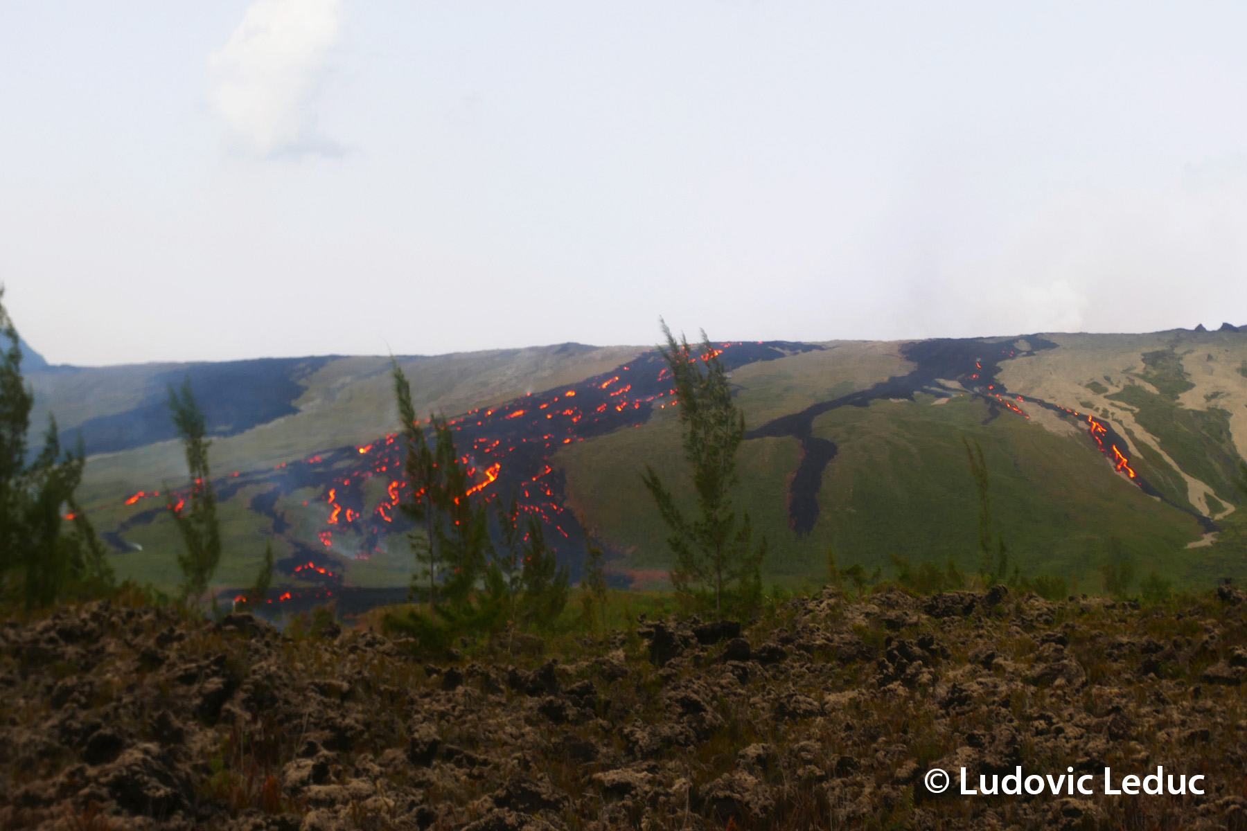
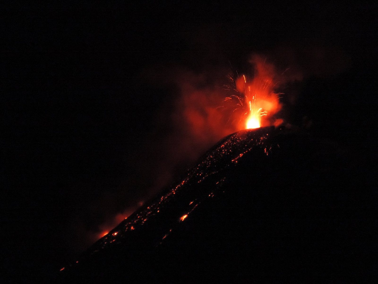
Only one eruptive site remains active on the south-southeast flank of the volcano at an altitude of 2,056 m, with a cone formed by the accumulation of ejected material, visible from Piton de Bert. On March 22, the lava level at the cone remained very high, with active eddies and recurring overflows associated with the rising of gas bubbles.
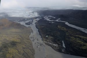
The lava field emitted from the eruptive site forms two main arms, each dividing into secondary arms. Over the past 24 hours, only the southern main arm has been active. The fronts of the two northern arms remained stationary, situated at approximately 660 meters altitude for the main northern arm and 690 meters for the secondary northern arm.
The southern arm, after splitting into several secondary arms, crossed the RN2 highway on March 13th and reached the ocean on March 16th.
Several secondary channels also formed downstream of the RN2 highway before the lava flow reached the ocean.
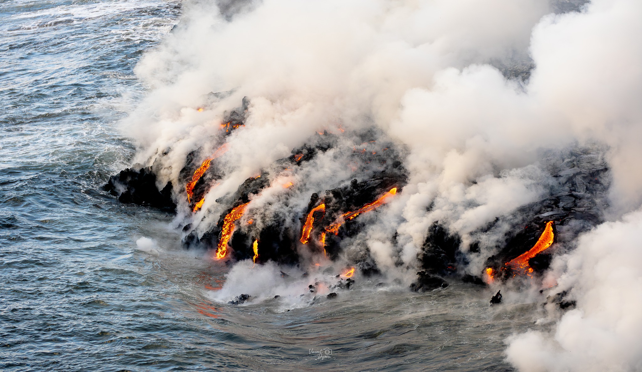
At the point of contact between the lava and the ocean, a platform continues to build and widen, resulting from the accumulation of lava flow and fine particles from lava fragmentation. Over the past 24 hours, the lava supply to the platform has been lower, and numerous lava tubes have developed; the lava is now mainly emerging only at the point of contact with the ocean. Small collapses have been observed along the edge of the platform due to wave action.
At this point of contact with the ocean, a gas plume is still present. This plume is mainly composed of water vapor, hydrochloric acid (HCl), and fine particles. When lava, at a temperature of approximately 1130°C, comes into contact with ocean water rich in sodium chloride, it generates an acidic aerosol in the form of fine suspended droplets. This plume also contains particles of pulverized lava and fragments of volcanic glass, which can be transported over several hundred meters to kilometers by the wind.
This plume, sometimes called « lava haze, » can be irritating and corrosive to the respiratory tract, skin, and eyes. Its dispersion is closely linked to local weather conditions. Furthermore, the sudden contact between lava and water can generate localized explosions, projecting molten material and jets of high-temperature steam in the immediate vicinity of the point of entry into the sea. Explosions could also occur if the platform becomes destabilized. Indeed, this platform, composed of an accumulation of lava flows and rock fragments, remains highly unstable and fragile. In the event of sudden destabilization, explosions of varying intensity could occur.
Significant seismic activity is still being recorded, although it is lower than in previous days, with 113 volcano-tectonic earthquakes detected on March 22nd. These earthquakes are located above the shallow reservoir (situated at a depth of approximately 1.5 to 2 km below the summit).
After a decrease observed between March 20 and 22, the intensity of the volcanic tremor has been relatively stable since March 22 at 4:00 PM UTC (8:00 PM local time). Over the past 24 hours, lava flow rates estimated using satellite data (HOTVOLC, OPGC-Université Clermont Auvergne) have decreased, with maximum values of 13 m³/s. It should be noted that these values may be underestimated due to observational biases, particularly those related to meteorological conditions (cloud cover), the development of lava tube flows, and the entry of the lava flow into the sea, which limit the detection of thermal radiation.
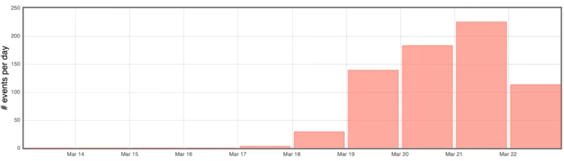
Number of summit volcano-tectonic earthquakes per day between March 13 and March 22, 2026 (©WebObs/OVPF-IPGP).
Summary
Observations at the different sites
– Eruptive site: the lava level at the cone remained very high with active eddies and recurring overflows associated with the rise of gas bubbles.
– Lava flows in the Grandes Pentes: only the southern arm was active in the last 24 hours.
– Platform: well-developed lava tube activity, with lava mainly emerging only at the point of contact with the ocean.
Small collapses were observed at the edge of the platform due to wave action.
Instrumental observations
– Seismicity remains significant (133 earthquakes on March 22, 2026).
-Deflation appears to have stopped. This parameter will be confirmed in the coming days.
– Tremor stable since March 22, 4 PM UTC.
– Flow rates decreasing (13 m³/s over the last 24 hours).
Alert Level 2.2
Source : OVPF / IPGP.
Photos : Vincent Dijoux ,Ludovic Leduc , OVPF.
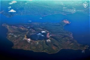
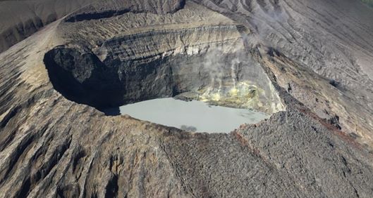
Italy , Stromboli :
Press release on Stromboli activity, March 22, 2026, 12:06 PM (11:06 UTC).
The National Institute of Geophysics and Volcanology, Etna Observatory, announces that analysis of surveillance camera images reveals ongoing eruptive activity
in the area of the North Crater, producing a lava flow whose fronts are located in the upper part of the Sciara del Fuoco.
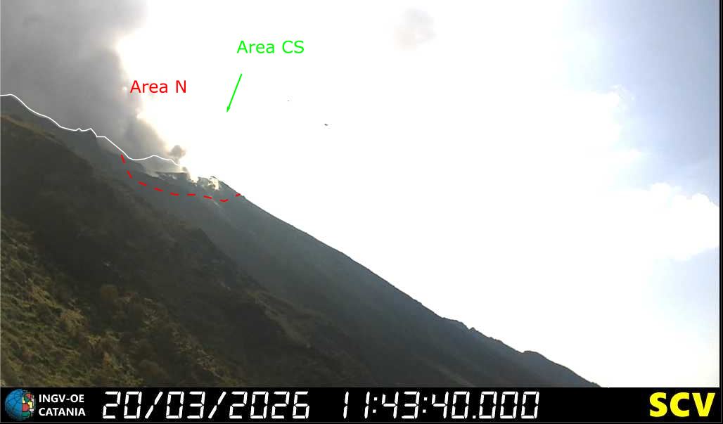
From a seismic perspective, the average amplitude of volcanic tremor is within the normal range. No significant variations in the occurrence rate or amplitude of explosion earthquakes were recorded.
Analysis of high-frequency GNSS network data detected no significant ground deformation.
Further information will be released soon.
Source et photo : INGV.
Indonesia , Lewotobi Laki-laki :
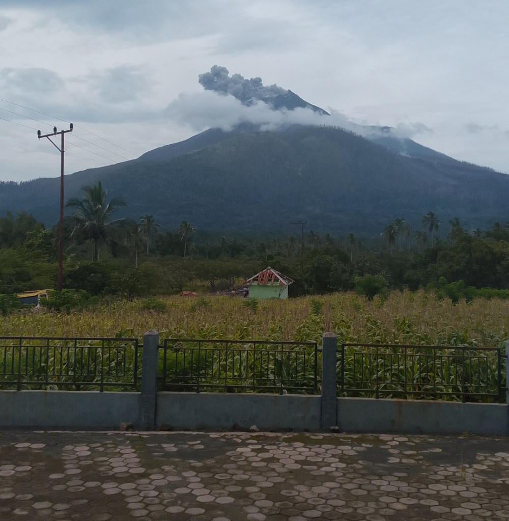
An eruption of Mount Lewotobi Laki-laki occurred on Monday, March 23, 2026, at 09:46 WITA. The observed ash column rose approximately 400 meters above the summit (about 1984 meters above sea level). This gray ash column was highly intense and directed northeast. The eruption was recorded by a seismograph, with a maximum amplitude of 7.4 mm and a duration of 159 seconds.
Seismic Observations
4 emission earthquakes with amplitudes between 2.2 and 10.5 mm and durations of 30 to 54 seconds.
1 harmonic tremor with an amplitude of 2.2 mm and a duration of 137 seconds.
2 non-harmonic tremors with amplitudes between 2.2 and 3.7 mm and durations of 88 to 150 seconds.
4 deep volcanic earthquakes with amplitudes between 2.2 and 22.2 mm and durations of 11 to 21 seconds.
9 distant tectonic earthquakes with amplitudes between 2.2 and 29.6 mm and durations of 43 to 352 seconds.
Recommendations
1. Residents living around Mount Lewotobi Laki-laki and visitors/tourists are asked to refrain from all activity within a 4 km radius of the eruption center.
2. The public is urged to remain calm, follow the instructions of local authorities, and not believe rumors from unknown sources.
Source et photo : PVMBG.
Ecuador , El Reventador :
REVENTADOR VOLCANO DAILY STATE REPORT, Sunday, March 22, 2026.
Information Geophysical Institute – EPN.
Surface Activity Level: High, Surface Trend: No Change
Internal Activity Level: Moderate, Internal Trend: No Change
From March 21, 2026, 11:00 AM to March 22, 2026, 11:00 AM:
Seismicity:
Due to technical issues at monitoring stations, no seismic events related to the volcano were recorded.
Rainfall/Lahars:
No precipitation was recorded in the volcano area during the last 24 hours. Heavy rainfall could remobilize accumulated material, generating mudflows and debris flows that would cascade down the volcano’s flanks and into nearby waterways.
Emissions/Ash Column:
From yesterday afternoon until the time of writing this report, several plumes of gas and ash have been detected by the GOES-19 satellite system drifting east, southeast, and east-southeast at an altitude of 1,000 to 1,200 meters above the crater. In connection with this activity, the Washington VAAC issued five reports of ash clouds at altitudes between 1,000 and 1,600 meters, drifting east, northeast, and east-southeast. Furthermore, according to these reports, yesterday afternoon (5:30 p.m. local time) and this morning (10:00 a.m. local time), thanks to information provided by the public and the National Risk Management Secretariat (SGR), light ashfall was reported in the locality of Gonzalo Díaz de Pineda, located in the canton of El Chaco, Napo province. The public is advised to take necessary precautions regarding ashfall and to consult official sources.
Other monitoring parameters:
The MIROVA-MODIS, MIROVA-VIIRS 375, and MIROVA-SENTINEL satellite systems recorded one thermal anomaly, the MIROVA-VIIRS 750 system recorded two, and the FIRMS satellite system recorded eight in the last 24 hours.
Observation:
From yesterday afternoon until the closing of this report, satellite monitoring shows that the area around the volcano remains partly cloudy.
Alert Level – SGR: Orange
Source et photo : IGEPN.
Costa Rica , Rincon de la Vieja :
Latitude: 10.83°N;
Longitude: 85.34°W;
Altitude: 1916 m
Current Activity Level: Alert.
No eruptions or exhalations have been recorded this week; the last recorded eruption was on February 17. Tremor is of variable amplitude and frequency, generally between 1 and 5 Hz. A brief sequence of short tremors was observed on March 15 and 16. Higher amplitude pulses were also observed on March 18 and 19. Harmonic and sliding tremors have been observed occasionally. Long-period, stable-magnitude tornillo-like events continue to occur. Since early March, the dominant frequency of these events has increased.
Two distal volcano-tectonic earthquakes were recorded this week south of the volcano, and one near the crater. The geodetic network is not recording any significant deformation. The MultiGAS station continues to detect very low gas concentrations. This week, DOAS stations recorded an SO₂ flux of 74 ± 20 t/d, lower than the previous week’s (310 ± 231 t/d). The last satellite detection of SO₂ in the atmosphere dates back to September 2025 (28 t/d).
Source : Ovsicori
Photo : Chris Allen de Sunquest Helitours