March 2 , 2026.
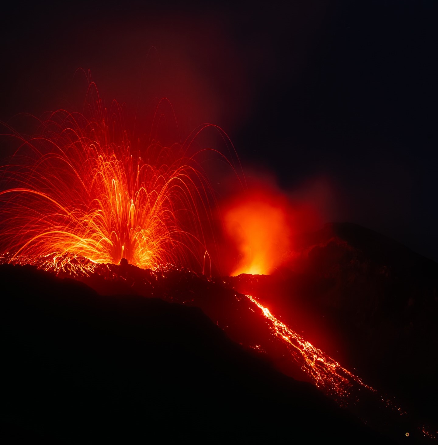
La Réunion Island , Piton de la Fournaise :
Press release from the Paris Institute of Earth Physics / Piton de la Fournaise Volcanological Observatory; March 2, 2026 – 9:15 a.m. local time – 5:15 a.m. UTC.
Eruption in progress
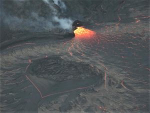
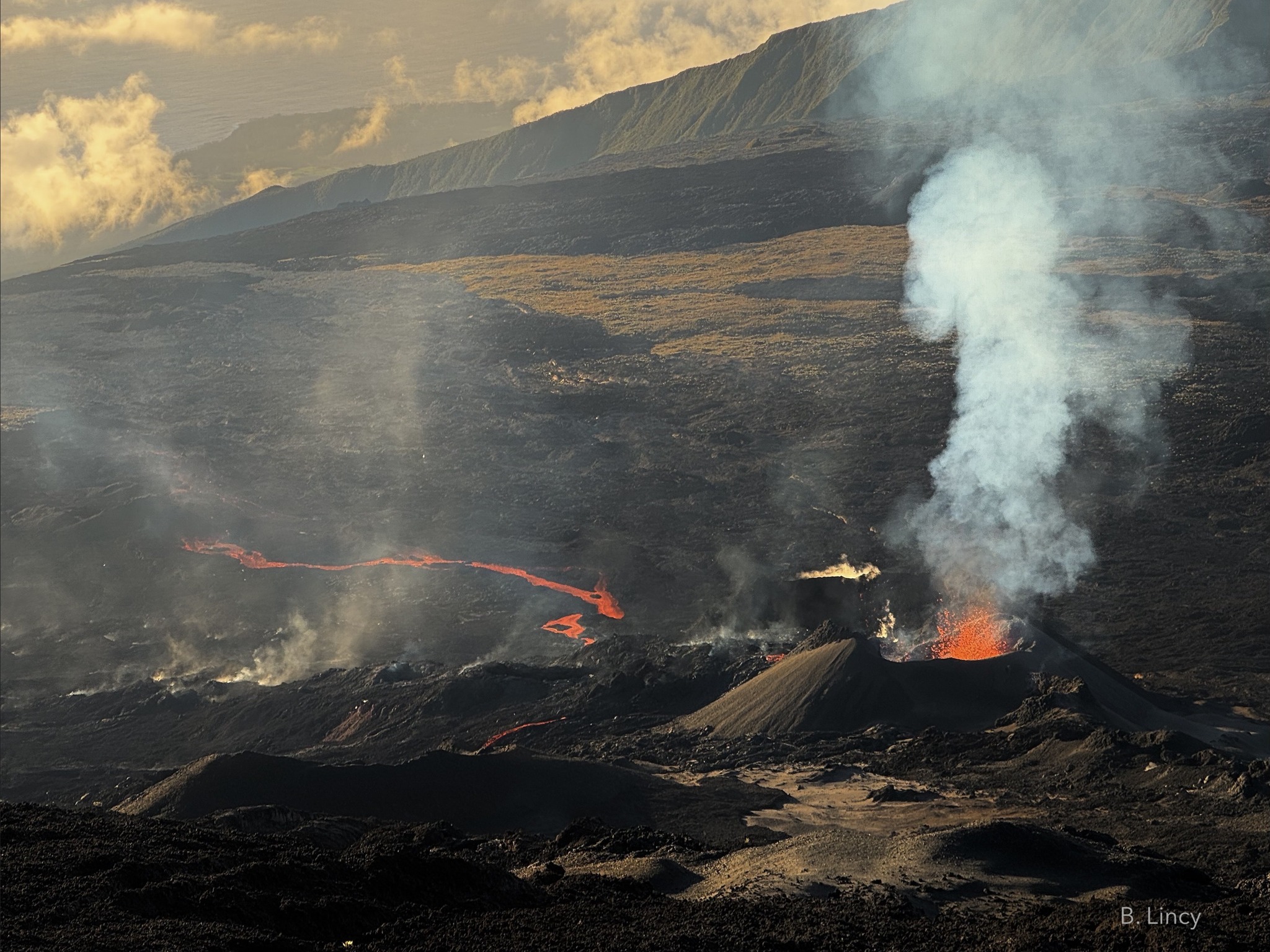
The eruption that began on February 13, 2026, shortly after 10:00 a.m. (local time), at Piton de la Fournaise continues.
Only one eruptive site remains active on the south-southeast flank of the volcano, with fountains still visible from Piton de Bert. A cone is being built by the progressive accumulation of lava flows. This cone is now closed laterally.
With the lateral closure of the cone, significant lava tube activity is now established downstream of the cone. The lava flow resurgences and active above-ground parts of the flow are concentrated downstream of the eruptive site and upstream of the Grandes Pentes fault, where the lava field widens and thickens. The lava flow front, however, remains stationary in the lower part of the Grandes Pentes, approximately 2.6 km from National Route 2 and at an altitude of 660 m.
As in previous days, seismic activity remains low.
The resumption of inflation of the edifice, visible on the summit GNSS stations and at the base of the cone, appears to be confirmed, even though the data has fluctuated over the last few days. This inflation remains low for the time being and would indicate a slight repressurization of the magma supply system, possibly linked to magma recharge from the shallow reservoir.
Over the past 24 hours, eruptive tremor (an indicator of lava and gas emissions at the surface) has remained relatively stable and of low amplitude. In the long term, a slow, gradual increase has been observed since February 21st, with small variations. Amplitude peaks are still being recorded and are likely linked to variations in degassing or morphological changes in the eruptive cone.
Surface flow rates, estimated from satellite data via the HOTVOLC platform (OPGC – Clermont Auvergne University), have indicated values between 1 and 14 m³/sec over the past 24 hours. It should be noted that these estimates can vary rapidly depending on cloud cover and become zero in the event of total cloud cover.
Summary
For the past few days, GNSS network data have suggested a slight inflation of the edifice. This development could be linked to a slight repressurization of the magma supply system, possibly related to a new phase of magma recharge in the shallowest reservoir. Given the current low seismic activity, the probability of new eruptive fissures opening remains low in the short term.
Nevertheless, the first signs of possible repressurization could increase this probability.
It should also be noted that in the past, eruptive fissures have opened during an eruption without any warning signs, such as in August 1998, July 1999, October 1999, December 2006, and March 2019. Indeed, magma propagation at shallow depths can occur aseismically, particularly when the magma has already been degassed.
Alert Level 2.1
Source : OVPF/IPGP.
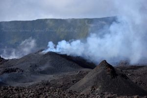
Photo : Benoit Lincy Volkaventure // Rando-Volcan
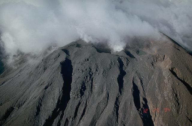
Ecuador , Sangay :
DAILY REPORT ON THE STATE OF SANGAY VOLCANO, Saturday, February 28, 2026.
Information Geophysical Institute – EPN.
Surface Activity Level: High, Surface Trend: No Change
Internal Activity Level: Moderate, Internal Trend: No Change
Seismicity: From February 27, 2026, 11:00 AM to February 28, 2026, 11:00 AM:
Seismicity: Due to technical problems at the monitoring stations, no seismic events related to the volcano could be recorded.
Rain/Lahars: Rainfall was recorded in the volcano area, but it did not generate mudflows or debris. **In the event of heavy rain, the accumulated materials could be remobilized, causing mud and debris flows that would cascade down the volcano’s flanks and flow into nearby rivers.**
Emission Columns/Ash:
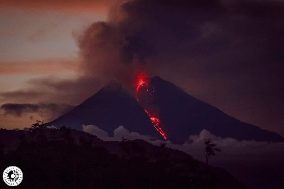
Due to adverse weather conditions, it was not possible to observe gas and ash emissions via the surveillance camera network. However, satellite imagery detected two emissions with columns reaching heights of 800 and 850 meters above the crater, both drifting north-northeast. In this regard, the Washington VAAC issued three reports of gas and ash emissions, all with columns reaching heights of 850 meters above the crater, drifting north-northeast, north, and northwest.
Gas:
The Mounts satellite system recorded 25.1 tons of SO₂ (sulfur dioxide), measured yesterday at 2:19 p.m. local time.
Other monitoring parameters:
Over the past 24 hours, the FIRMS and MIROVA-MODIS satellite systems detected 1 and 2 thermal anomalies, respectively. The MIROVA-VIIRS system recorded 4.
Observation:
From yesterday afternoon until the time of this report, the volcano has remained completely obscured by clouds.
Alert level: Yellow
Source : IGEPN
Photo : Camara Rota
Italy , Stromboli :
Press release on Stromboli volcano activity, March 1, 2026, 6:42 PM (5:42 PM UTC).
The National Institute of Geophysics and Volcanology, Etna Observatory, announces that analysis of images from surveillance cameras shows moderate effusive activity underway in the area of the North Crater, producing a lava flow whose fronts are located in the upper part of the Sciara del Fuoco.
From a seismic perspective, the average amplitude of volcanic tremor is currently within the normal range. No significant changes have been observed in the frequency and amplitude of explosion earthquakes.
No significant changes have been detected in the GNSS network data.
Further information will be released soon.
Source : INGV
Photo : Stromboli stati d’animo / Sebastiano Cannavo
Philippines , Bulusan :
BULUSAN VOLCANO ADVISORY, 2 March 2026 , 11:00AM
Notice of increased seismic activity at Bulusan Volcano.
A total of forty-nine (49) volcanic earthquakes have been recorded by Bulusan Volcano Network (BVN) since 3:00 AM of 26 February 2026. Of these, sixteen (16) were volcano-tectonic (VT) earthquakes associated with rock fracturing between 3 to 6 kilometers beneath the northern and southeastern edifice of Bulusan Volcano. In contrast, all other monitoring parameters have remained in the background levels. Degassing activity from the summit crater and active vents have been very weak to moderate when the volcano is visible for the past days. Volcanic sulfur dioxide (SO2) emission from the summit vents has also been too weak to be detected during last measurement on 26 February 2026.
Alert Level 0 is maintained over Bulusan Volcano, which means that no magmatic eruption is foreseen. However, recent increases in seismicity may indicate that hydrothermal processes beneath the volcano are underway and may lead to sudden steam-driven or phreatic eruption. The public is reminded that entry into the 4-kilometer radius Permanent Danger Zone (PDZ), particularly near the vents on the south-southeastern slopes, should be avoided due to the possibility of sudden and hazardous steam-driven or phreatic eruption, rockfall, landslides and other related volcanic hazards. Local government units must prepare their response and revisit their emergency plans in case the status of the volcano is raised to Alert Level 1. Civil aviation authorities must also advise pilots to avoid flying close to the volcano’s summit as ash from any sudden phreatic eruption can be hazardous to aircraft. DOST-PHIVOLCS is closely monitoring Bulusan Volcano’s condition and any new development will be relayed to all concerned.
Source et photo : DOST-PHIVOLCS.
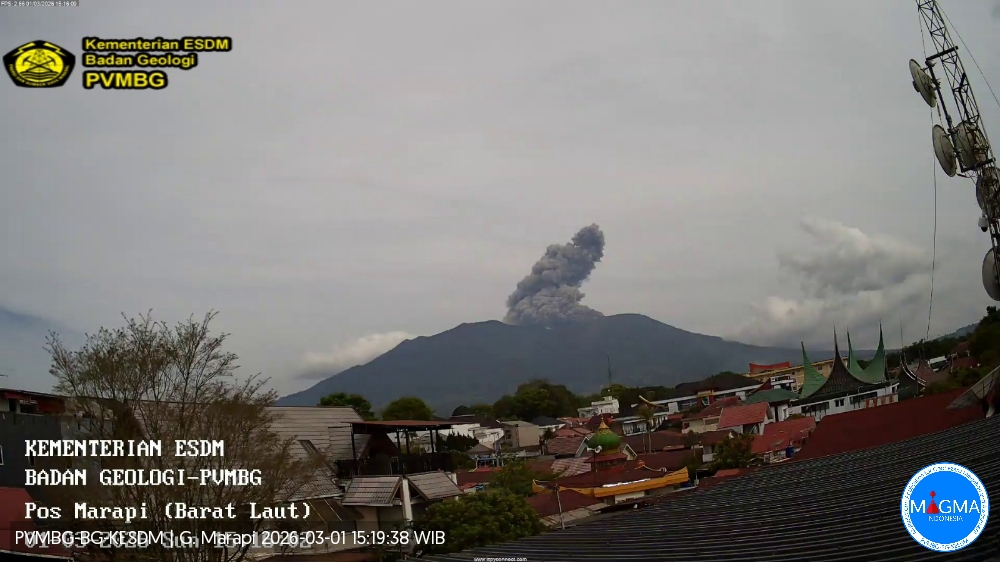
Indonesia , Marapi :
Mount Marapi experienced an eruption on Sunday, March 1, 2026 at 3:11 PM (Jakarta local time). An ash column was observed approximately 1,500 meters above the summit (at an altitude of about 4,391 meters). This ash column was gray and denser in the southeast direction. The eruption was recorded by a seismograph with a maximum amplitude of 29.8 mm and a duration of 68 seconds.
VOLCANO OBSERVATORY NOTICE FOR AVIATION – VONA
Issued : March 01 , 2026
Volcano : Marapi (261140)
Current Aviation Colour Code : ORANGE
Previous Aviation Colour Code : yellow
Source : Marapi Volcano Observatory
Notice Number : 2026MAR029
Volcano Location : S 0 deg 22 min 52 sec E 100 deg 28 min 23 sec
Area : West Sumatra, Indonesia
Summit Elevation : 9251 FT (2891 M)
Volcanic Activity Summary :
Eruption with volcanic ash cloud at 08h11 UTC (15h11 local).
Volcanic Cloud Height :
Best estimate of ash-cloud top is around 14051 FT (4391 M) above sea level or 4800 FT (1500 M) above summit. May be higher than what can be observed clearly. Source of height data: ground observer.
Other Volcanic Cloud Information :
Ash cloud moving to southeast. Volcanic ash is observed to be gray. The intensity of volcanic ash is observed to be thick.
Remarks :
Eruption recorded on seismogram with maximum amplitude 29.8 mm and maximum duration 68 second.
Source et photo : Magma Indonésie.