February 17 , 2026.
Hawaii , Kilauea :
HAWAIIAN VOLCANO OBSERVATORY STATUS REPORT , U.S. Geological Survey
Monday, February 16, 2026, 12:04 AM HST (Monday, February 16, 2026, 10:04 UTC)
19°25’16 » N 155°17’13 » W,
Summit Elevation 4091 ft (1247 m)
Current Volcano Alert Level: WATCH
Current Aviation Color Code: ORANGE
Activity Summary:
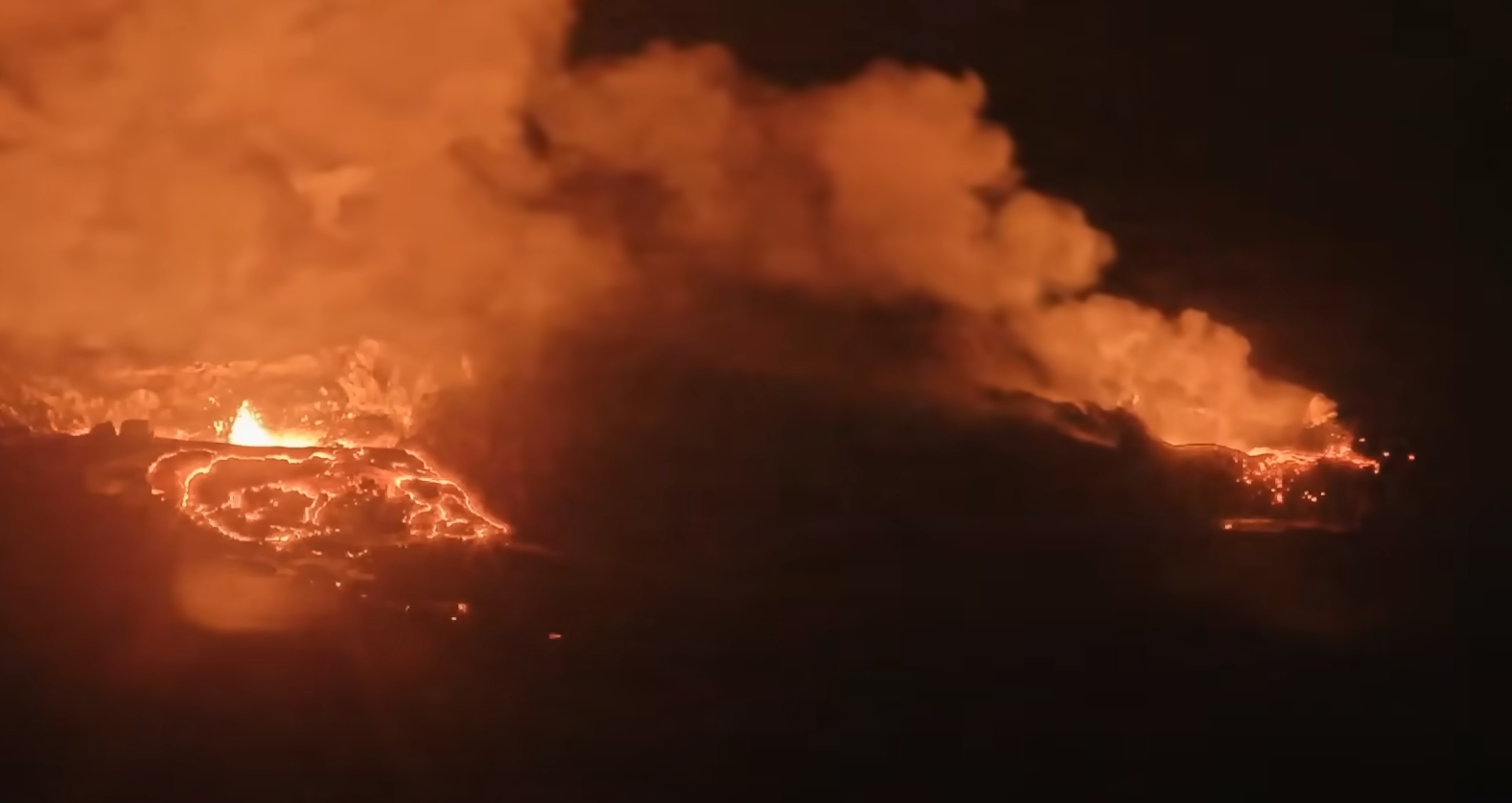
Episode 42 of the ongoing Halemaʻumaʻu eruption ended at 11:38 p.m. HST on February 15, 2026, and the ongoing Halemaʻumaʻu eruption is currently paused.
Tephra fall outside of the closed area of Hawaiʻi Volcanoes National Park was relatively light during episode 42.
Episode 42 Chronology:
Episode 42 lava fountaining from the north and south vents stopped at approximately 11:38 p.m. HST on February 15. The south vent dropped rapidly, then jetted back up for about 30 seconds between 11:34 and 11:36 p.m. HST. During the last 2 minutes, activity from the south vent was mostly narrow jets. The north fountain began to slowly drop in height but jetted back up about a minute before the episode ended. Episode 42 ended after 9 hours and 48 minutes with both the north and south vents active for most of the eruption. The highest peak or instantaneous effusion rate of 1000 cubic yards (780 cubic meters) per second occurred around 3:00 p.m. HST on February 15. Episode 42 ended with an average effusion rate of 430 cubic yards per second (330 cubic meters per second). An estimated 15 million cubic yards (11.4 million cubic meters) of lava erupted and covered about 50% of Halemaʻumaʻu crater floor. The Uēkahuna tiltmeter (UWD) recorded about 33.7 microradians of deflationary tilt during episode 42.
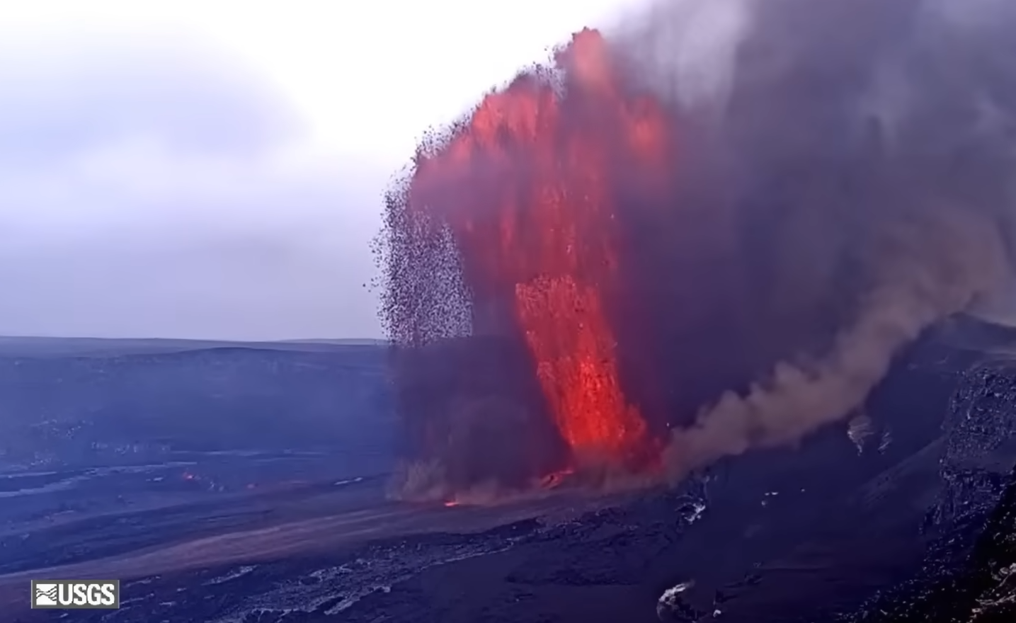
The onset of episode 42 fountaining of the ongoing Halemaʻumaʻu eruption occurred at 1:50 p.m. HST on February 15, 2026, marked by a sharp increase in tremor and deflationary tilt at recorded at the Uēkahuna tiltmeter (UWD). North and south vent fountain heights peaked between 2:00 and 3:00 p.m. HST, with maximum fountain heights during the episode estimated at around 400 m (1300 feet) from the south vent. The north vent fountain reached about 300 meters (1000 feet). Light tephra fall consisting mostly of fine ash and Peleʻs hair was reported falling in Pahala, Punaluʻu, and Nāʻāehu to the southwest of Halemaʻumaʻu crater in Hawaiʻi Volcanoes National Park
Initial precursory activity began on February 14 at 1:05 p.m. HST with a very short, small overflow from the north vent. This was followed by two more north vent overflows at 4:41 p.m. and 5:56 p.m. lasting 9 and 6 minutes respectively. Intermittent spattering continued throughout the night and up until episode 42 fountains began. Overflows resumed from the south vent on the morning of February 15 at 3:51 a.m. and again at 4:06 a.m. HST, both lasting only a few minutes. There were three or four tiny overflows from both vents prior to noon, which is when the north vent vigorously overflowed from 12:13 to 12:22 p.m. That north vent flow was followed by the overflows from the south vent at 12:20 p.m. HST. There were about a dozen precursory flows prior to the onset of continuous eruptive activity. There were only a few short breaks before overflows became continuous from the south vent at 1:08 p.m. HST. The north vent began overflowing continuously just after 1:20 p.m. HST with fountain heights growing gradually to over 20 meters (60-70 feet) high prior to the onset of episode 42.
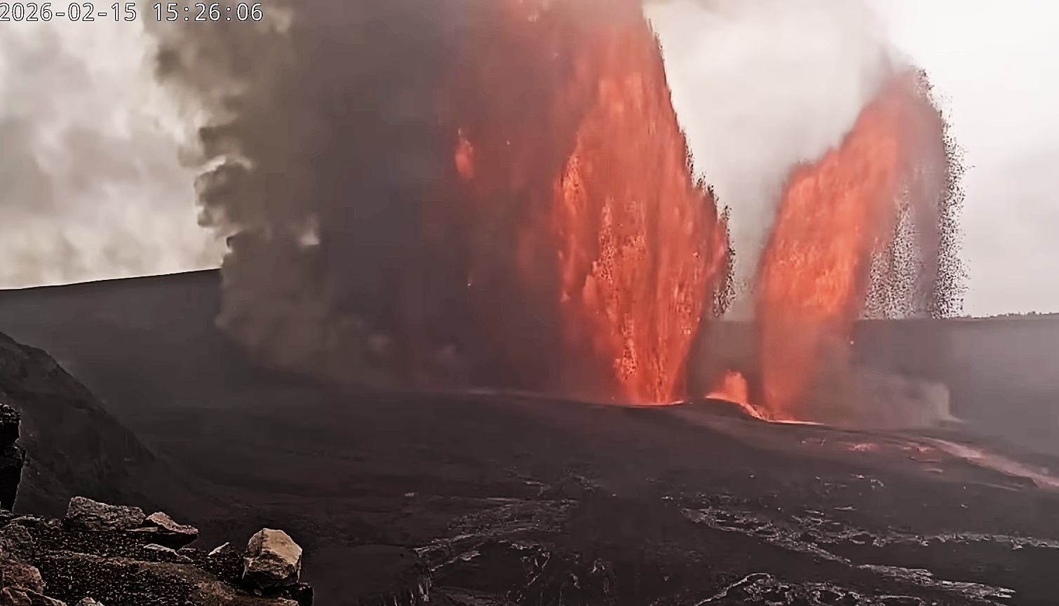
Tremor began to rapidly increase and tilt started to drop rapidly when episode 42 fountains began at approximately 1:50 p.m. HST. At first, the north vent grew rapidly, exceeding 100 meters (330 feet) in height by 2:10 p.m. and 200 meters (660 feet) by 2:25 p.m. HST. The south vent remained relatively small until just before 2:30 p.m. and by 2:30 p.m. it equaled the north vent fountain in size. By 2:40 p.m. the south vent fountain exceeded the height of the north vent fountain and remained that way for the rest of the eruption. Peak heights were reached around 3:00 p.m. HST and fountains remained there for the next 1-2 hours with a peak effusion rate just under 800 cubic meters per second (1050 cubic yards per second). The dual fountains produced significant heat and ash, which, by around 3:00 p.m. HST, created a large plume that reached 10,600 meters (35,000 feet) in altitude according to the National Weather Service. Rainy and cloudy weather during this period made it difficult to accurately measure the fountain heights, but the south vent was somewhere between 330 to 400 meters (1100 and 1300 feet) high, while the north vents was about 250-300 meters (800-1000) feet high. Both fountain heights very gradually decreased until about 4:45 p.m., when the south vent began to oscillate between 250 meters and 400 meters (800 feet and 1300 feet) in short bursts. This behavior lasted until about 6:00 p.m. HST. Following that, both the south and north fountains slowly declined to about 180 meters (600 feet) and 150 meters (500 feet), respectively, by 11:00 p.m. HST.
Only light tephra fall was reported in communities to the southwest during episode 42 as compared to the widespread, heavy tephra fall associated with episode 41. Reported tephra fall was fine-grained ash and Pele’s hair during episode 42. Episode 42 was similar to, but slightly smaller than episode 41 in size, eruptive style, fountain height, and volume of eruptive lava. The principal difference impacting tephra distribution appears to have been the presence of light Kona winds from the southwest during episode 41 and strong trade winds from the northeast during episode 42.
Source et photos : HVO.
La Réunion Island , Piton de la Fournaise :
Press release from the Paris Institute of Earth Physics, Piton de la Fournaise Volcanological Observatory, February 16, 2026 – 11:10 a.m. local time – 7:10 a.m. UTC
Eruption in progress
The eruption that began on February 13, 2026, shortly after 10:00 a.m. local time, at Piton de la Fournaise continues.
Only one eruptive site remains active at present. Lava fountains have built a volcanic cone against Piton Morgabim, on the south-southeast flank of the volcano.
Yesterday, around 2:00 p.m. (local time, or 10:00 a.m. UTC), the collapse of an old cinder cone located just downstream of the eruptive cone was observed, generating small pyroclastic flows. This collapse is likely linked to the accumulation of lava upstream of this cone, whose structure eventually gave way. The interaction between lava and water probably promoted the production of an associated phreatic activity (sudden vaporization of water in contact with the lava).
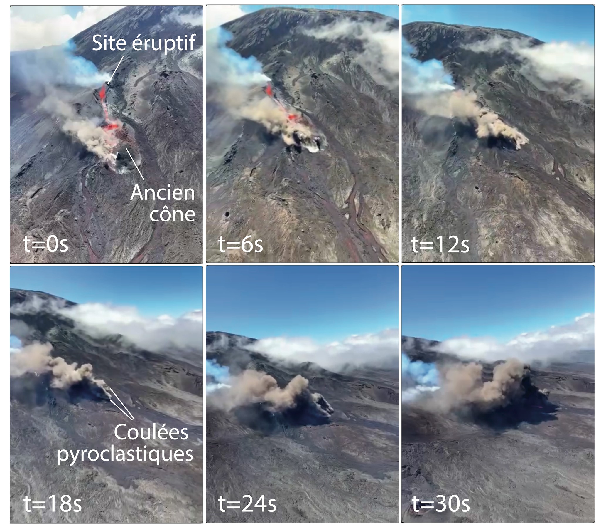
A sequence of images shows the collapse of an old cinder cone downstream of the eruptive site, followed by the emplacement of small pyroclastic flows. Interval between images: 6 seconds. (Credits: Clément Dijoux).
The intensity of the eruptive tremor (an indicator of lava and gas emissions at the surface) increased around 4:00 PM local time yesterday (12:00 UTC) and decreased slightly overnight.
Surface flow rates, estimated from satellite data via the HOTVOLC platform (OPGC – Université Clermont Auvergne), showed values between 2 and 28 m³/sec over the last 24 hours. It should be noted that these estimates can vary rapidly depending on cloud cover and be zero in the event of total cloud cover.
A field reconnaissance carried out this morning, with the assistance of the SAG (Gulf Rescue Service) and the PGHM (High Mountain Gendarmerie Platoon), confirmed sustained activity at the eruptive site, with lava fountains reaching approximately 15 meters in height above the forming cone. Following yesterday’s collapse downstream of the eruptive site, the lava flows have reorganized into a well-defined channel upstream of Grandes Pentes. Sampling of the active flows was successfully completed during this reconnaissance mission.
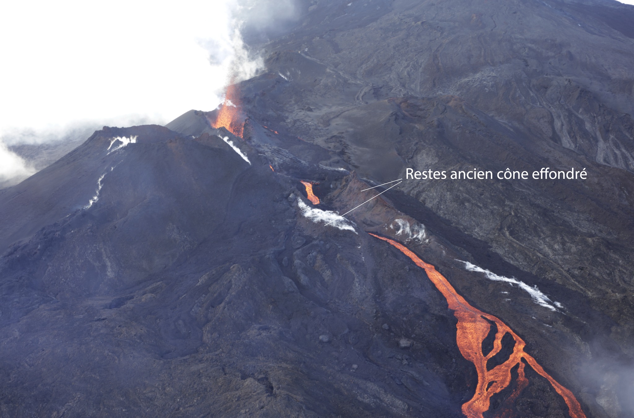
Channelled lava flows crossing the remains of the collapsed cone near the eruptive site. Image taken on February 16, 2026, at 8:00 a.m. local time (4:00 a.m. UTC) (©OVPF-IPGP)
The lava flow front has stalled in the lower part of the Grandes Pentes, approximately 2.6 km from the road and at an altitude of 660 m (distance estimated by a drone survey on the ground on Sunday, February 15, 2026). The active parts of the flow are still concentrated at the top of the Grandes Pentes.
The continued seismic activity beneath the summit indicates that the lava supply system remains under pressure; new fissure openings are still possible in the coming hours, particularly further downstream. The OVPF-IPGP remains on continuous alert to monitor the situation.
Alert Level 2.1
Source : OVPF-IPGP.
Indonesia , Merapi :
Seismic Observations
27 avalanche earthquakes with amplitudes ranging from 2 to 19 mm and durations ranging from 51.44 to 189.43 seconds.
One low-frequency earthquake with an amplitude of 3 mm and a duration of 12.54 seconds.
Seventeen hybrid/multiphase earthquakes with amplitudes ranging from 2 to 31 mm and durations ranging from 15.4 to 48.45 seconds.
One shallow volcanic earthquake with an amplitude of 6 mm and a duration of 13.28 seconds.
One distant tectonic earthquake with an amplitude of 2 mm and a duration of 40.3 seconds.
VOLCANO OBSERVATORY NOTICE FOR AVIATION – VONA
Issued : February 16 , 2026
Volcano : Merapi (263250)
Current Aviation Colour Code : YELLOW
Previous Aviation Colour Code : yellow
Source : Merapi Volcano Observatory
Notice Number : 2026MER005
Volcano Location : S 07 deg 32 min 31 sec E 110 deg 26 min 31 sec
Area : Special Region of Yogyakarta, Indonesia
Summit Elevation : 9498 FT (2968 M)
Volcanic Activity Summary :
Increasing in volcanic activity.
Volcanic Cloud Height :
Ash-cloud is not observed.
Other Volcanic Cloud Information :
Ash-cloud is not observed.
Remarks :
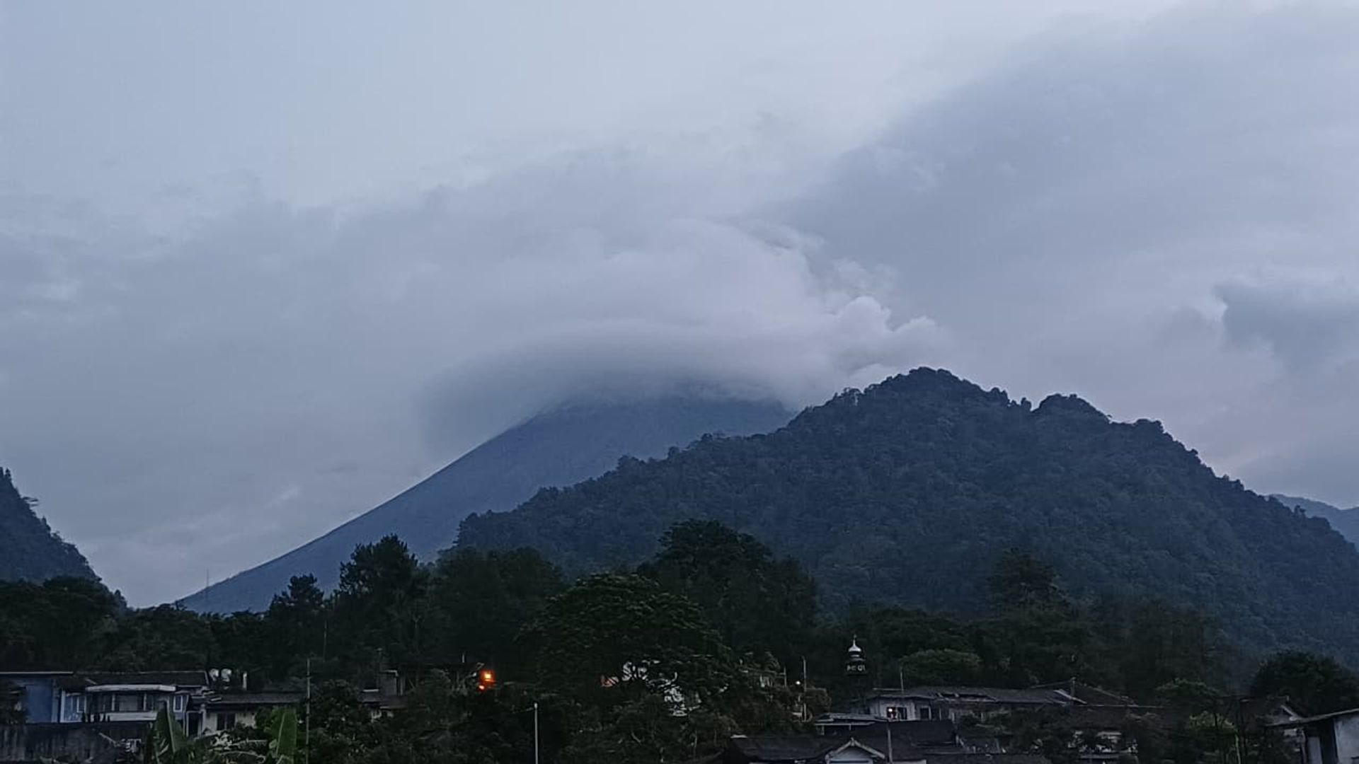
The volcano is clearly visible to cloudy. No gas emission is observed. The weather is cloudy to rainy, with light to moderate winds from the west.
Source et photo : Magma Indonésie .
Costa Rica , Rincon de la Vieja :
Latitude: 10.83°N;
Longitude: 85.34°W;
Altitude: 1916 m
Current Activity Level: Alert.
A slight exhalation was recorded on February 11; however, eruptive activity has been very low since January 6, 2026. Background tremor has remained very weak for most of the week. Long-period and tornillo-type events continue to occur. Two volcano-tectonic earthquakes distal to the crater were recorded this week. The low frequency of eruptions, the low tremor amplitude, and the appearance of long-period signals suggest a possible closure of cavities or conduits where volatile compounds are accumulating.
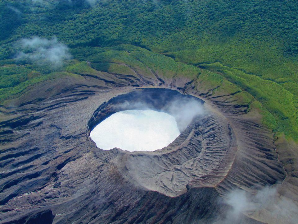
Therefore, the possibility of moderate eruptions cannot be ruled out. Geodetic observations show no significant deformation. The slight summit extension observed previously is diminishing. The MultiGAS station continues to detect very low gas concentrations.
This week, DOAS stations recorded an SO₂ flux of 97 ± 51 t/d, similar to that of the previous week (95 ± 46 t/d). The last satellite detection of SO₂ in the atmosphere dates back to October 2025 (3 tonnes).
Source : Ovsicori.
Photo : Raul Mora / RSN / UCR
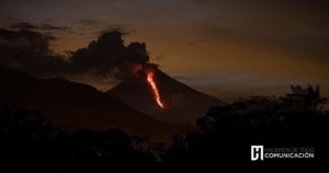
Guatemala , Santiaguito :
Atmospheric conditions: Clear skies
Wind: North
Rainfall: 0 mm
Activity:
Activity is being recorded at the Caliente dome of the Santa María-Santiaguito volcanic complex. Weak white degassing fumaroles are observed 300 meters above the crater, along with weak to moderate explosions at a rate of 0 to 1 per hour, which are ejecting columns of gas and ash up to an altitude of 3,400 meters. These columns are drifting west and southwest under the influence of the wind. Incandescent blocks of rock may break off from the volcano’s flanks.
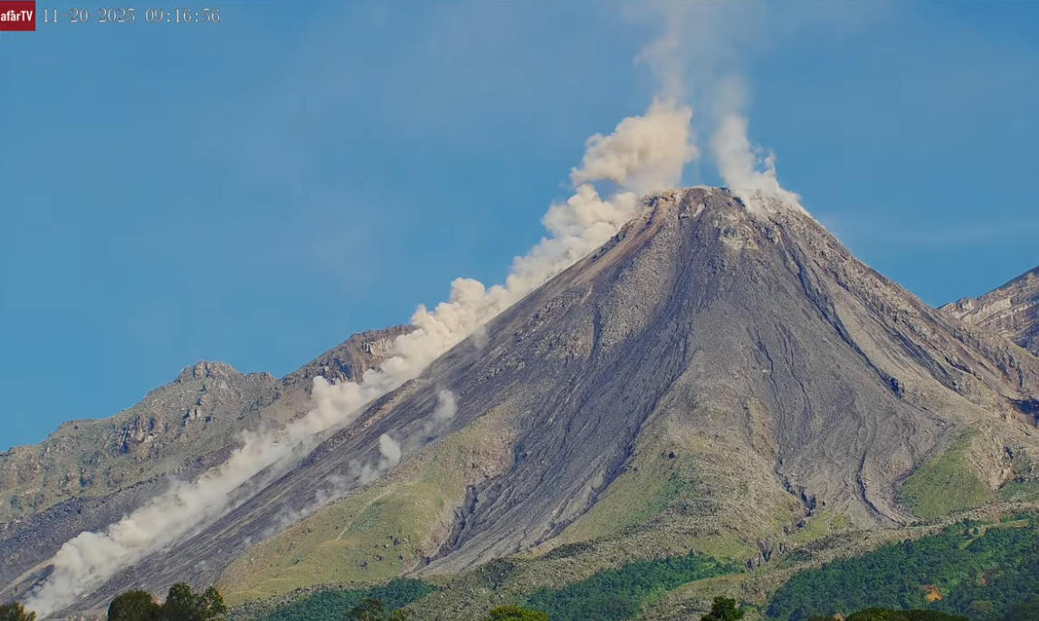
Due to the wind direction, light ashfall may occur in the mountainous areas of Monte Claro village and its surroundings. Because of the abundant accumulation of rock material on the Caliente dome and on the promontory overlooking the lava flow on its southwest flank, the generation of long-distance pyroclastic density currents in all directions cannot be ruled out; therefore, it is recommended to follow the instructions in Special Bulletin BESAN-063-2025.
Source : Insivumeh.
Photo : Afar tv.