February 14 , 2026.
La Réunion Island , Piton de la Fournaise :
Press release from the Paris Institute of Earth Physics / Piton de la Fournaise Volcanological Observatory, February 13, 2026 – 10:10 a.m. local time – 6:10 a.m. UTC
Eruption begins
Following the seismic crisis that began at 9:25 a.m. local time, volcanic tremor, indicating the arrival of magma near the surface, has been recorded since approximately 10:00 a.m. local time.
Analysis of the data and observations from our cameras show that the eruptive fissure(s) have opened near the summit on the southern flank of the volcano.
Eruption in progress.
Press release from the Paris Institute of Earth Physics / Piton de la Fournaise Volcanological Observatory, February 14, 2026 – 6:30 a.m. local time – 2:30 a.m. UTC
Eruption in progress
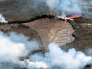
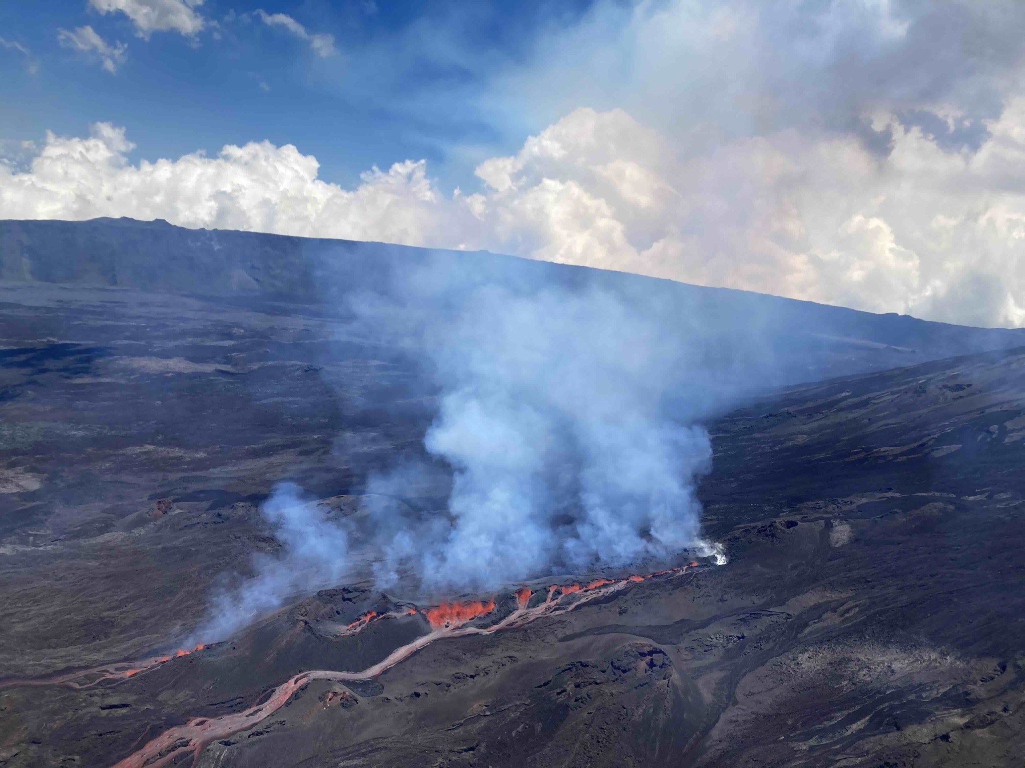
The eruption that began on February 13, 2026, shortly after 10:00 a.m. local time, at Piton de la Fournaise continues.
Only one active fissure remains, located near Piton Morgabim on the south-southeast flank (Figure 1). Yesterday in the late afternoon, the lava flows reached the Grandes Pentes. After a rapid initial spread in the early evening, the flow front has been propagating very slowly since 10:00 p.m., advancing approximately 300 meters between 10:00 p.m. and 6:00 a.m. This morning, it was located about 3 km from the RN2 highway.
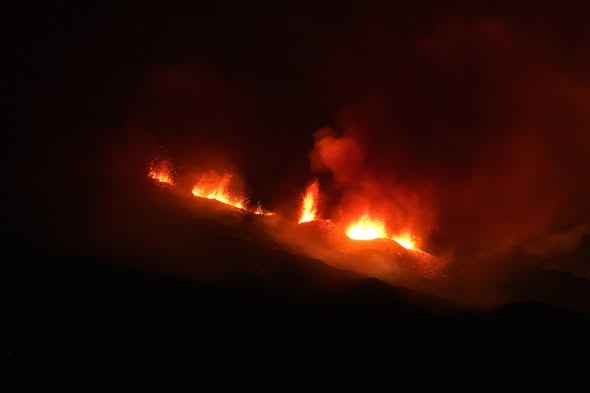
The intensity of the eruptive tremor (an indicator of lava and gas emissions at the surface) has decreased by a factor of approximately half since the start of the eruption and has remained relatively stable over the last four hours.
Surface flow rates, estimated from satellite data via the HOTVOLC platform (OPGC – Clermont Auvergne University), showed values for the night ranging from 2 to 19 m³/sec (with a peak of 33 m³/sec). It should be noted that these estimates can change rapidly depending on cloud cover.
Due to continued seismic activity, new fissure openings remain possible in the coming hours, particularly further downstream. The OVPF-IPGP remains on continuous alert to monitor the situation.
Alert level: Alert 2-1
Source et photos : direction de l’OVPF-IPGP
Indonesia , Semeru :
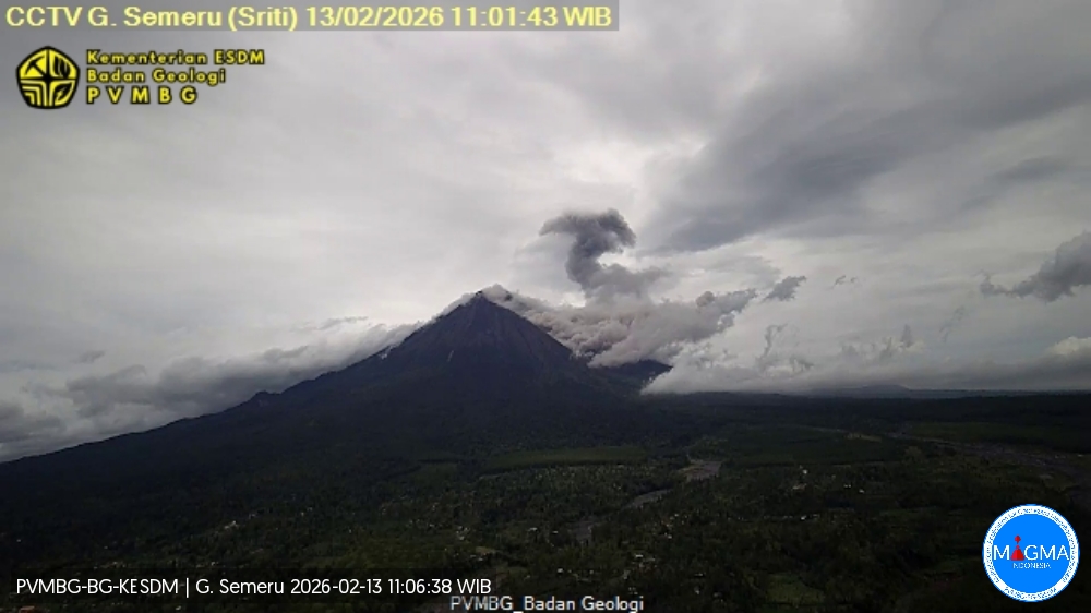
Mount Semeru erupted on Friday, February 13, 2026, at 10:56 AM Western Indonesian Time. An ash column was observed approximately 1,000 meters above the summit (at an altitude of about 4,676 meters). This ash column was gray and very dense, oriented to the north and northeast. The eruption was recorded by a seismograph, with a maximum amplitude of 20 mm and a duration of 250 seconds.
Seismic Observations:
17 eruption earthquakes with amplitudes ranging from 14 to 23 mm and durations from 64 to 119 seconds.
2 pyroclastic avalanche earthquakes with amplitudes ranging from 20 to 25 mm and durations from 275 to 2388 seconds.
Four avalanche earthquakes with amplitudes of 2 to 5 mm and durations of 31 to 152 seconds.
Three emission earthquakes with amplitudes of 3 to 5 mm and durations of 31 to 75 seconds.
Two non-harmonic tremors with amplitudes of 6 to 10 mm and durations of 393 to 1103 seconds.
VOLCANO OBSERVATORY NOTICE FOR AVIATION – VONA
Issued : Fébruary 13 , 2026
Volcano : Semeru (263300)
Current Aviation Colour Code : ORANGE
Previous Aviation Colour Code : orange
Source : Semeru Volcano Observatory
Notice Number : 2026SMR310
Volcano Location : S 08 deg 06 min 29 sec E 112 deg 55 min 12 sec
Area : East java, Indonesia
Summit Elevation : 11763 FT (3676 M)
Volcanic Activity Summary :
Eruption with volcanic ash cloud at 03h56 UTC (10h56 local).
Volcanic Cloud Height :
Best estimate of ash-cloud top is around 14963 FT (4676 M) above sea level or 3200 FT (1000 M) above summit. May be higher than what can be observed clearly. Source of height data: ground observer.
Other Volcanic Cloud Information :
Ash cloud moving from north to northeast. Volcanic ash is observed to be gray. The intensity of volcanic ash is observed to be thick.
Remarks :
Eruption recorded on seismogram with maximum amplitude 20 mm and maximum duration 250 second.
Source et photo : Magma Indonésie.
Colombia , Galeras :
San Juan de Pasto, February 10, 2026, 3:30 PM
Regarding the monitoring of activity at the Galeras volcano, the Colombian Geological Survey (SGC), an agency under the Ministry of Mines and Energy, reports the following:
For the period from February 3 to 9, 2026, the main variations in monitored parameters compared to the previous week were as follows:
● Despite low volcanic activity, an increase in seismic frequency and energy release was observed. Seismicity associated with rock fracturing processes within the volcanic edifice remained predominant.
● The recorded seismicity was characterized by low energy levels. Most events occurred near the main crater, with a few others in the northeast sector, at distances of less than 10.5 km. The depths were less than 10.8 km below the summit of the Galeras volcano (4,200 m altitude), with magnitudes less than 1.6.
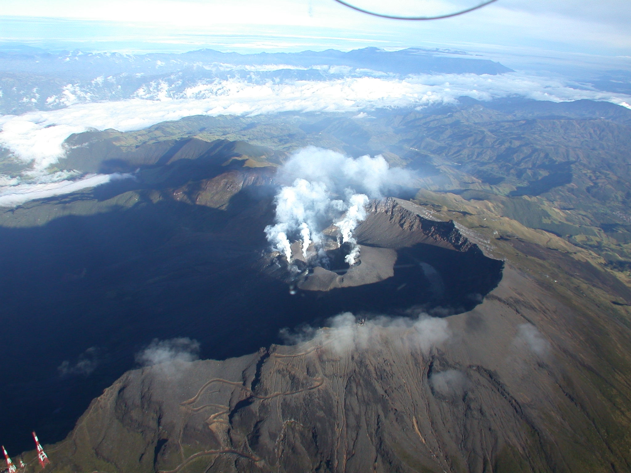
● During the week, low-altitude plumes of white gas were observed, with varying dispersion depending on wind direction. These plumes originated primarily from the fumarole fields of El Paisita to the north, Las Chavas to the west, and the main crater.
● Other volcanic monitoring parameters remained stable.
Given the above, the Geological Survey of Colombia (SGC) recommends closely monitoring its evolution through weekly bulletins and other information published via its official channels, as well as following the instructions of local and departmental authorities and the National Unit for Disaster Risk Management (UNGRD).
● Volcanic activity remains at the yellow alert level: Active volcano with changes in the baseline behavior of monitored parameters and other manifestations.
Source et photo : SGC.
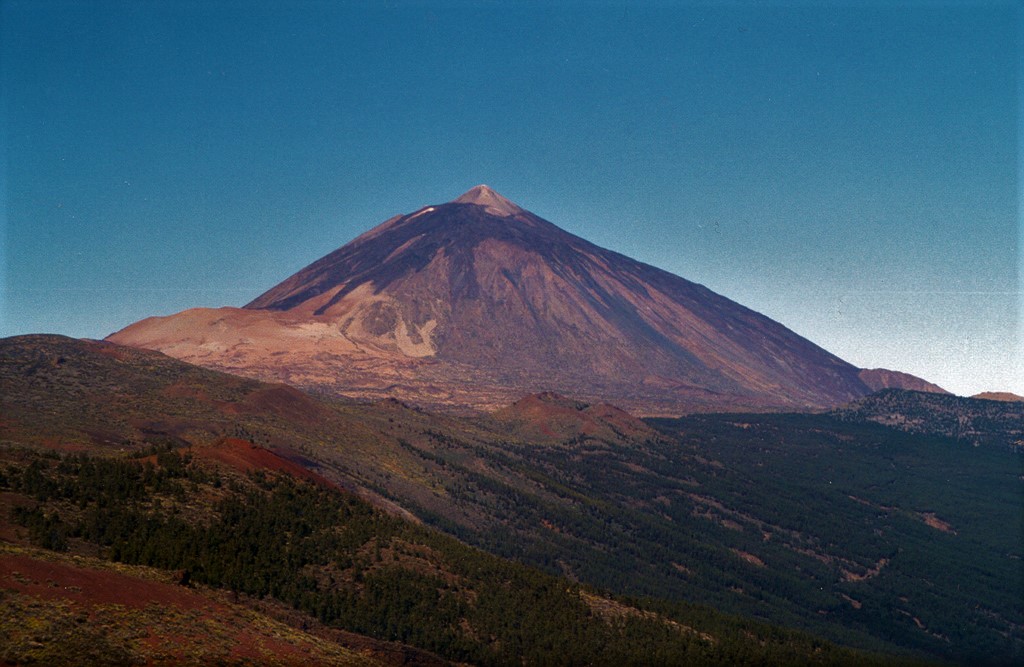
Spain / Canary Islands , Tenerife :
The Canary Islands seismic network of the Canary Islands Volcanological Institute (Involcan) recorded a new swarm of hybrid events in Tenerife, consisting of several hundred very low-amplitude signals, between 5:20 p.m. on Thursday and 4:00 a.m. on Friday. The National Geographic Institute (IGN) detailed that there were some 876 very low-magnitude seismic events, the maximum being 0.7 mbLg, making it a “very low-energy” swarm.
The agency explained that due to this low magnitude, it is not possible to locate all the seismic events individually. However, the joint analysis of the series indicates that it occurred in the western area of Las Cañadas del Teide, a zone where seismic swarms of similar characteristics have already been recorded in October 2016, June 2019, June and July 2022, November 2024, and August 2025. “The estimated depth of this series is approximately 8 kilometers below sea level, which is also consistent with that of previous episodes,” he adds.
This is therefore the seventh swarm of this type detected on the island since October 2, 2016.
Involcan maintains that the “most likely” hypothesis is that these swarms are linked to the injection of magmatic fluids into the island’s hydrothermal system.
This process has been observed repeatedly since 2016 and is supported by independent geochemical and geophysical data, including increased diffuse CO2 emissions in the Teide crater and slight ground deformation detected in the northeast sector of Mount Teide, the organization emphasizes on social media.
In this context, it insists that this episode “does not change the probability of an eruption in Tenerife in the short and medium term,” although it specifies that “the loudest volcanic noise” has been recorded in Tenerife since the end of 2016 and “there is no evidence of attenuation.” The detected earthquakes, according to the National Geographic Institute, were located at an average depth of approximately 10 kilometers, with magnitudes ranging from 0.1 to 1.9 mbLg. The last of the tremors occurred at 1:51 a.m. (local time) this Friday.
This swarm occurred just hours after the second unusual signal located in this area, following the first on Tuesday. In both cases, it was a long-duration tremor (approximately 90 minutes) at a depth of about 10 kilometers. The continuous seismic signal was low-frequency (2–10 Hz) and reached its maximum amplitude between 9:00 a.m. and 10:15 a.m. on February 10.
Source : El diario . es
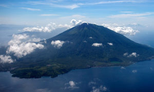
Photo : Alexander Belousov, 2001 (Institute of Volcanology, Kamchatka, Russia).
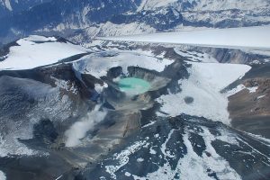
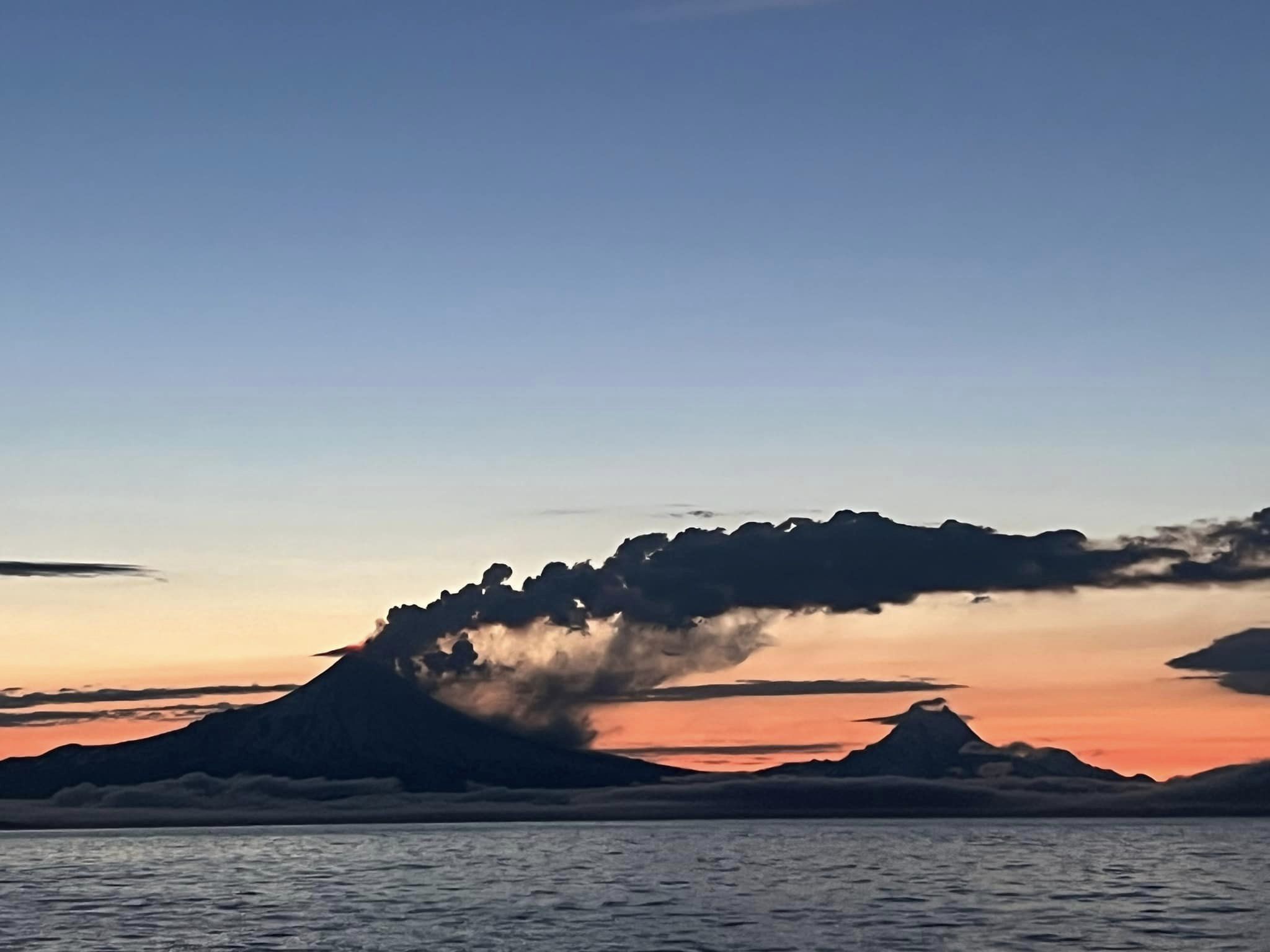
Alaska , Shishaldin :
Signs of volcanic unrest at Shishaldin Volcano continued this week. Low-level seismic activity, including frequent small volcanic earthquakes and volcanic tremor, was detected throughout the week. Infrasound signals were mostly obscured by high winds. Minor steaming was observed in webcam views when the weather was clear. Satellite detection of sulfur dioxide emissions was hampered by cloud cover during the week.
Shishaldin Volcano is monitored by local seismic and infrasound sensors, web cameras, and a telemetered geodetic network. In addition to the local monitoring network, the Alaska Volcano Observatory uses nearby geophysical networks, regional infrasound and lightning data, and satellite data to monitor the volcano.
Source : AVO
Photo : Nick Enloe ( archive).