Hawaii , Kilauea :
HAWAIIAN VOLCANO OBSERVATORY STATUS REPORT , U.S. Geological Survey
Tuesday, August 25, 2026, 8:22 PM HST (Wednesday, August 26, 2026, 06:22 UTC)
19°25’16 » N 155°17’13 » W,
Summit Elevation 4091 ft (1247 m)
Current Volcano Alert Level: ADVISORY
Current Aviation Color Code: YELLOW
Summary:
Episode 54 of the ongoing Halemaʻumaʻu eruption began around 10:30 a.m. HST and ended at 7:33 p.m. HST on August 25, 2026, after 9 hours of continuous lava fountaining.
Activity Summary:
Episode 54 of the ongoing Halemaʻumaʻu eruption began around 10:30 a.m. HST and ended at 7:33 p.m. HST on August 25, 2026, after 9 hours of continuous lava fountaining.
The maximum lava fountain height from the north vent was approximately 500 feet (150 meters) above ground level, reached between 12:15 p.m. and 1:00 p.m. HST. Neither the south vent nor the new west vent (formerly the collapse pit) fountained during this episode.
The maximum plume height was approximately 17,000 feet (5,200 meters) above sea level.
Most tephra fall was restricted to the closed area of Hawaiʻi Volcanoes National Park, southwest of the active eruptive vents in Halemaʻumaʻu. However, HVO did also receive a report of trace Pele’s hair falling in the Ka‘ū district of the Island of Hawaiʻi.
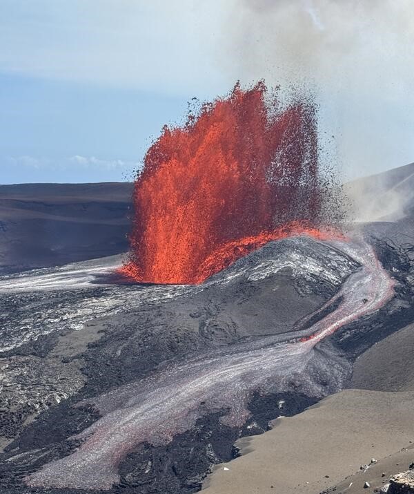
The lava fountain erupting from the north vent in Halemaʻumaʻu at the summit of Kīlauea during episode 54 on August 25, 2026, generated a lava flow on the caldera-wall side of the vent complex. This lava flow skirted the northwest part of the caldera wall. Significant lava flows fed by the north vent lava fountain also traveled away from the vent on the south part of Halemaʻumaʻu.
Episode 54 Chronology:
Lava fountaining episode 54 in Halemaʻumaʻu at the summit of Kīlauea began around 10:30 a.m. HST and ended at 7:33 p.m. HST on August 25, 2026, after 9.0 hours of continuous lava fountaining from the north vent. Neither the south vent nor the new west vent (formerly the collapse pit) fountained during this episode. The instantaneous effusion rate from the north vent peaked at about 290 cubic yards (220 cubic meters) per second between 11:45 a.m. HST and 12:15 p.m. HST. The average effusion rate over the entire episode was approximately 140 cubic yards (110 cubic meters) per second. An estimated 5.2 million cubic yards (4.0 million cubic meters) of lava erupted and covered about 30% of the Halemaʻumaʻu crater floor. Seismicity followed the normal pattern for most fountaining episodes, with rapidly increasing tremor at the beginning of the episode, followed by a gradual decline through its main stages, followed by an abrupt drop at the end of the episode. The Uēkahuna tiltmeter (UWD) recorded approximately 12.7 microradians of deflationary tilt during episode 54.
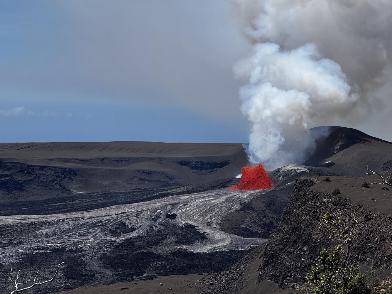
Episode 54 of lava fountaining in Halemaʻumaʻu at the summit of Kīlauea began at 10:30 HST on August 25, 2026. At the time this photograph was taken, from the north rim of the caldera around 11 a.m., the fountain from the north vent was about 50-75 feet (15-20 meters) meters high.
Following the onset of relatively rapid summit inflation yesterday, August 24, north vent spatter was observed in overnight webcam views starting just after 7:00 p.m. HST and tremor turned from continuous to well defined gas piston cycles 5–10 minutes apart. Spattering from the north vent continued to build through the evening until after midnight when it became more continuous. Bright glow, flames, and occasional spatter were observed from the west vent and correlated with tremor peaks produced by drainback during gas piston cycles. There were only a few, rare glimpses of weak glow from the south vent.
This morning, August 25, there were two precursory overflows from the north vent: the first from 6:16 to 6:37 a.m. HST and the second from 7:27 to 8:12 a.m. HST. There were no overflows from either the west or south vents. A third north vent overflow began at 8:52 a.m. HST and continued until it transitioned into the onset of episode 53 lava fountaining at 10:30 a.m. HST. The transition from precursory activity to the onset of episode 54 lava fountaining was marked by increasing height of the north vent dome fountain, greater eruptive volume, increased deflation and rapidly increasing tremor. At this point a surging dome fountain began feeding a vigorous flow into Halemaʻumaʻu crater. The north vent lava fountain grew rapidly over the next hour and reached a peak height of approximately 500 feet (150 meters) around 12:15 p.m. HST and remained at that height until about 1:00 p.m. HST. The high fountain produced significant heat and some tephra, feeding a gas plume that reached a maximum height of about 17,000 feet (5,200 meters) above sea level based on webcam images.
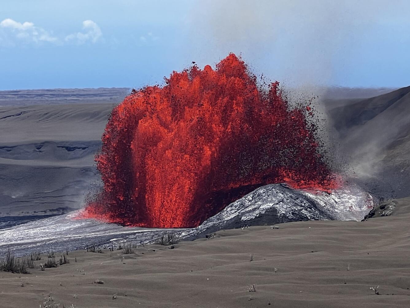
Lava fountains from the north vent in Halemaʻumaʻu, at the summit of Kīlauea volcano in Hawaiʻi Volcanoes National Park during episode 54 on August 25, 2026.
By 1:30 p.m. HST on August 25, fountain heights decreased to about 350 feet (110 meters) above ground level, and plume heights decreased to 14,000 feet (4,200 meters) above sea level. Fountain heights then remained mostly constant until the early evening. However, the plume heights continue to decrease and were below 12,000 feet (3,700 meters) at this time. The fountain heights began to decrease after 6:00 p.m. HST reaching 160 feet (50 meters) just before 7:00 p.m. HST. The final fountains were about 100–200 feet (30–60 meters) high during the last half hour of the eruption, and the plume cloud was down to about 7,000 feet (2,100 meters). Episode 54 ended abruptly at 7:33 p.m. HST on August 26, with the last 3 minutes were marked by gas jetting and flames from the north vent.
Winds were out of the northeast during fountaining but decreased in velocity above the inversion layer, which was around 12,000 feet (3,650 meters) above sea level. The northeast winds carried the gas and fine ash and Peleʻs hair in the plume toward the southwest. Most tephra fall was restricted to the closed area of Hawaiʻi Volcanoes National Park, southwest of the active eruptive vents in Halemaʻumaʻu. However, HVO did also receive a report of trace Pele’s hair falling in the Ka‘ū district of the Island of Hawaiʻi.
The abrupt switch from summit deflation to inflation at the end of episode 54 and the resumption of low frequency tremor bursts indicate that another lava fountaining episode is likely in the coming weeks.
Source : HVO
Photos : USGS / M. Patrick. USGS / K. Mulliken. ,USGS / C. Gansecki.
Indonesia , Lewotobi Laki-laki :
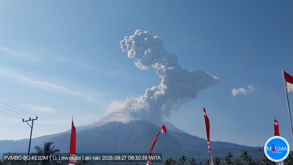
An eruption of Mount Lewotobi Laki-laki occurred on Thursday, August 27, 2026, at 08:30 WITA, with an ash column reaching a height of approximately 2,500 m above the summit (or about 4,084 m above sea level). The observed ash column was gray and dense, drifting towards the southwest and west. The eruption was recorded by the seismograph with a maximum amplitude of 47.3 mm and a duration of 125 seconds.
Seismic observations
3 eruptive earthquakes with amplitudes of 10.5–47.3 mm and durations of 80–271 seconds.
1 harmonic tremor with an amplitude of 22.2 mm and a duration of 66 seconds.
5 non-harmonic tremors with amplitudes of 4.4–7.4 mm and durations of 67–98 seconds.
1 deep volcanic earthquake with an amplitude of 7.4 mm and a duration of 22 seconds.
23 distant tectonic earthquakes with amplitudes of 5.9–47.3 mm and durations of 43–129 seconds.
Recommendations
1. Communities near Mount Lewotobi Laki-laki, as well as visitors and tourists, must not conduct any activities within a 5 km radius of the Mount Lewotobi Laki-laki eruption center.
2. The public is advised to remain calm, follow instructions from local authorities, and disregard information from unverified sources.
Source et photo : PVMBG.
Colombia , Galeras :
San Juan de Pasto, August 25, 2026, 2:20 PM
Based on the monitoring of activity at the Galeras volcano, the Colombian Geological Service (SGC)—an agency attached to the Ministry of Mines and Energy—reports the following:
During the week of August 18–24, 2026, the main variations in monitored parameters compared to the previous week were as follows:
● Amidst a context of low activity and fluctuating behavior of the Galeras volcanic complex, seismicity decreased in frequency but increased in terms of energy released, remaining primarily associated with rock fracturing. Among the recorded events, two stand out with magnitudes greater than 2.0: the first, recorded on August 23 with a local magnitude of 2.6, was located 9.3 km northeast of the Galeras volcano at a depth of 10.1 km; the second event occurred on August 24 with a local magnitude of 2.1, located 12.6 km southwest of the summit (4,276 meters above sea level) at a depth of 14.9 km.
The other events were scattered within a radius of 2 to 12 km, at depths of less than 10 km.
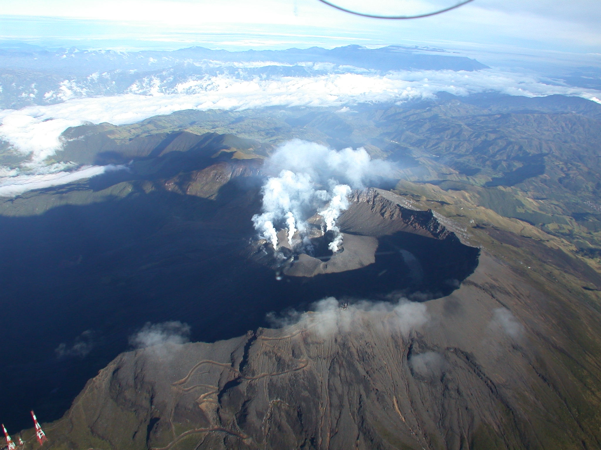
● Low-altitude emissions of white gas were recorded and dispersed according to wind direction. These emissions originated primarily from the El Paisita (north) and Las Chavas (west) fumarole fields and the main crater.
● Other volcanic monitoring parameters remained stable.
In light of the above, the SGC recommends closely monitoring the volcano’s activity via weekly bulletins and other information published through our official channels,
and adhering to the instructions issued by local and departmental authorities and the National Unit for Disaster Risk Management (UNGRD). Volcanic activity remains at the yellow alert level: an active volcano showing changes in the baseline behavior of monitored parameters and other manifestations.
Source et photo : SGC.
Guatemala , Santiaguito :
Weather conditions: Clear
Wind: Northeasterly
Precipitation: 31.5 mm
Activity
White gas emissions are observed above the active dome; fumaroles are rising up to 400 meters above the crater and dispersing towards the west and southwest. Between 2 and 4 explosions—ranging from low to moderate intensity—were recorded early this morning.
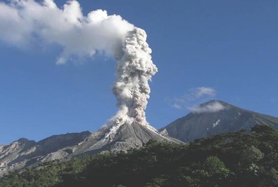
Furthermore, crater incandescence has been reported, accompanied by collapses and the descent of incandescent blocks along the flanks. Given the high level of volcanic activity, the possibility of long-range pyroclastic density currents forming cannot be ruled out; it is therefore recommended to follow the instructions in special bulletin BESAN-002-2026.
Source et photo : Insivumeh.
Alaska , Great Sitkin :
Slow eruption of lava within the summit crater continues. Minor earthquakes were detected over the past day. No activity was observed in cloudy satellite and webcam images over the past day.
The current eruption began in July 2021. Since then, lava flows have filled most of the summit crater and advanced into valleys below. There have been no explosions at Great Sitkin Volcano since an event in May 2021. The volcano is monitored using local seismic and infrasound sensors, satellite data, webcams, and regional infrasound and lightning networks.
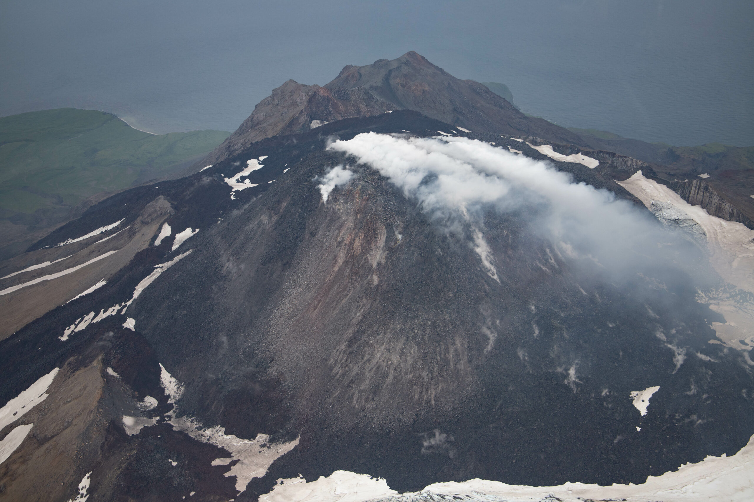
Aerial photo of the active lava dome in the summit crater of Great Sitkin
During May-January 2026, satellite radar images showed growth of the lava dome. The flow expanded slightly to the south and thickened over the vent. Occasional rockfalls were noted in seismic data off the dome and flow. Steaming and elevated surface temperatures were occasionally observed when weather allowed.
The alert levels have remained at ORANGE/WATCH since July 23, 2021.
Source : AVO
Photo : Hannah Dietterich / AVO/USGS .