April 8 , 2026.
La Réunion Island , Piton de la Fournaise :
Press release from the Paris Institute of Earth Physics / Piton de la Fournaise Volcanological Observatory, April 8, 2026 – 7:00 a.m. local time – 3:00 a.m. UTC
Tremor
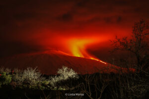
A tremor* has been recorded since 8:40 p.m. (local time, 4:40 p.m. UTC) on April 3. The source of this tremor is located on the east-southeast flank of the volcano and is positioned in the same location as during the eruptive phases from February 13 to April 3.
The intensity of the tremor decreased sharply yesterday evening, April 7, around 7:00 p.m. local time (3:00 p.m. UTC). Following this decrease, an intermittent tremor, or « gas piston, » was observed for several hours until a further increase around 5:30 a.m. local time (1:30 a.m. UTC) this morning. The amplitude of this tremor remains weak at present, and no lava emissions are visible on the observatory’s cameras. This signal nevertheless indicates the presence of magma at shallow depths and the emission of gases; thus, a resumption of lava flows cannot be ruled out. It should be noted that, in the past, phases of tremor without lava emissions have been observed at Piton de la Fournaise, although this remains rare.

Seismicity
Since the cessation of surface eruptive activity on April 3 at 00:10 (local time), seismicity beneath the summit has decreased. No volcano-tectonic earthquakes have been recorded in the last 24 hours.
Deformation
Concurrently, slight inflation of the summit area of the volcano has been observed again since the end of surface eruptive activity, indicating a re-pressurization of the shallow magma reservoir.
*Volcanic tremor: a near-continuous seismic signal associated with the circulation of magmatic and/or gaseous fluids within the volcanic edifice. Its source mechanisms can include fluid flow, flow instabilities, and the resonance of fluid-filled conduits or fractures.
Source : OVPF-IPGP
Photo : Imaz Press Réunion
Italy / Sicily , Etna :
MONTHLY BULLETIN, MARCH 2026. (Publication date: 07/04/2026)
ACTIVITY SUMMARY
Based on monitoring data, the following points should be noted:
1) VOLCANOLOGICAL OBSERVATIONS: Degassing activity at varying rates at the summit craters, with episodic emissions of volcanic ash from the Bocca Nuova crater.
2) SEISMOLOGY: Overall, fracturing seismic activity was moderate, with the exception of the seismic sequence of March 3 and 4 (Mmax = 4.5), which affected the lower southeast flank of the volcano. The average amplitude of volcanic tremor remained low to moderate, but was characterized by 9 fluctuations that also reached high values.
3) INFRASOUND: Low-energy infrasound activity with varying frequencies, ranging from low to high.
4) GROUND DEFORMATION: Ground deformation monitoring networks have not measured significant long-term variations, only small variations coinciding with episodes of significant volcanic tremor.
5) GEOCHEMISTRY: SO₂ flux at an average level.
CO₂ flux from the ground (Etnagas): stable at average values.
Partial pressure of dissolved CO₂ in groundwater (Rete EtnaAcque): no update.
Helium isotope ratio at peripheral sites: high values (latest data from March 23, 2026).
6) SATELLITE OBSERVATIONS: Over the past month, satellite-observed thermal activity in the summit area has been generally low, with a few isolated moderate anomalies.
VOLCANOLOGICAL OBSERVATIONS
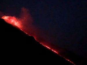
During the month, Etna’s volcanic activity was monitored through the analysis of images from the INGV – Osservatorio Etneo (INGV-OE) surveillance cameras and through direct observations conducted on-site by INGV-OE staff. Remote observations were interrupted several times due to adverse weather conditions at the summit of Etna. Overall, during the period under review, Etna’s activity was characterized by degassing at the summit craters, with episodic emissions of volcanic ash from the Bocca Nuova crater.
Analysis of images from INGV-OE surveillance cameras and inspections carried out by INGV-OE staff (on March 2 and 12) revealed predominantly fumarolic degassing along the rims of the Voragine Crater (VOR) and the Southeast Crater (CSE). The Northeast Crater (CNE) exhibited pulsatile degassing activity of varying intensity. The Bocca Nuova Crater (BN) was characterized by degassing activity of varying intensity. In particular, on March 4 at 12:12 UTC, an impulsive emission of volcanic ash occurred, which dispersed within minutes in the eastern quadrants. During the inspection on March 12, INGV-OE personnel observed intense degassing at the BN, accompanied sporadically by emissions of reddish ash that quickly dispersed into the atmosphere. Sporadic emissions of volcanic ash were recorded by INGV-OE surveillance cameras on March 5 and 29.
Source : INGV.
Photo : Giovinsky Aetnensis / FB.
Indonesia , Dukono :
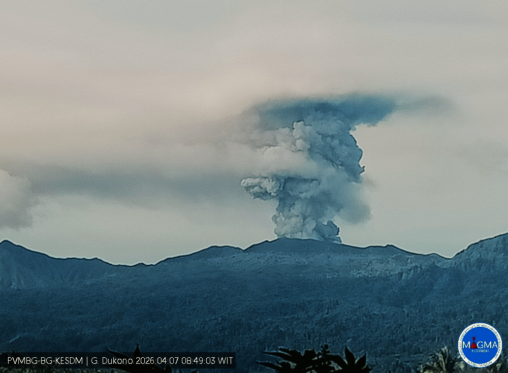
Mount Dukono experienced an eruption on Tuesday, April 7, 2026 at 7:54 AM WIT. An ash column was observed approximately 1,000 meters above the summit (at an altitude of about 2,087 meters). This ash column, white to gray in color, was highly concentrated and extended to the southeast. At the time of writing, the eruption was still ongoing.
VOLCANO OBSERVATORY NOTICE FOR AVIATION – VONA
Issued : April 7 , 2026
Volcano : Dukono (268010)
Current Aviation Colour Code : ORANGE
Previous Aviation Colour Code : orange
Source : Dukono Volcano Observatory
Notice Number : 2026DUK020
Volcano Location : N 01 deg 41 min 35 sec E 127 deg 53 min 38 sec
Area : North Maluku, Indonesia
Summit Elevation : 3478 FT (1087 M)
Volcanic Activity Summary :
Eruption with volcanic ash cloud at 22h54 UTC (07h54 local).
Volcanic Cloud Height :
Best estimate of ash-cloud top is around 6678 FT (2087 M) above sea level or 3200 FT (1000 M) above summit. May be higher than what can be observed clearly. Source of height data: ground observer.
Other Volcanic Cloud Information :
Ash cloud moving to southeast. Volcanic ash is observed to be white to gray. The intensity of volcanic ash is observed to be thick.
Remarks :
Eruption and ash emission is continuing. Eruption recorded on seismogram with maximum amplitude 14 mm. Tremor recorded on seismogram with maximum amplitude 4 mm.
Source et photo : PVMBG
Italy , Stromboli :
WEEKLY BULLETIN, March 30, 2026 to April 5, 2026. (Publication date: April 7, 2026)
ACTIVITY SUMMARY
Based on monitoring data, the following points should be noted:
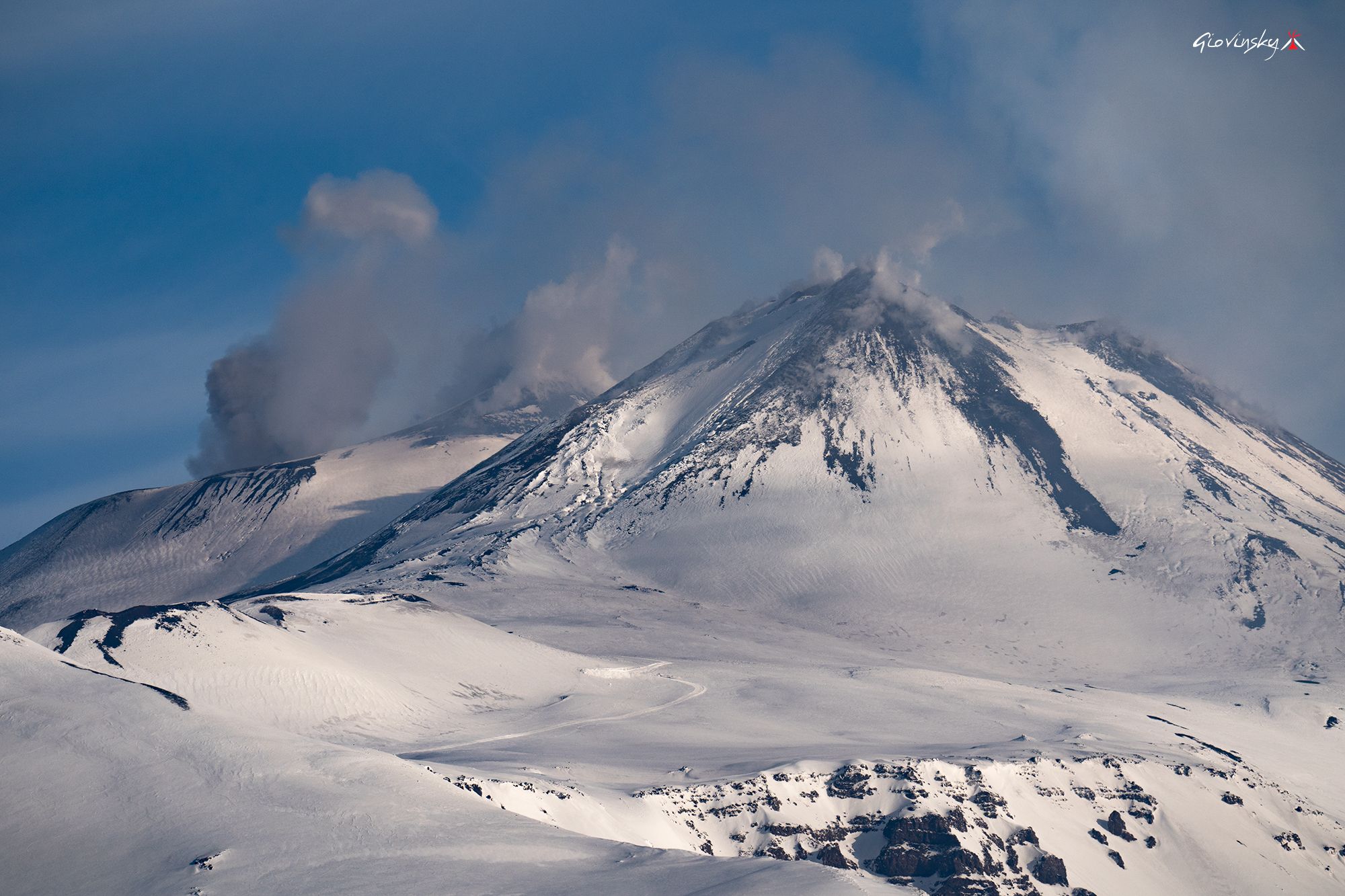
1) VOLCANOLOGICAL OBSERVATIONS: Ordinary Strombolian-type eruptive activity and non-ordinary activity with effusivity due to lava overflows in the North Crater area. Occasionally intense ejection activity in the North Crater area. Average total hourly frequency and low intensity in the North and Central-South Crater areas.
2) SEISMOLOGY: Monitored seismic parameters show no significant changes.
3) GROUND DEFORMATION: GNSS network signals showed no significant changes.
The clinometer network was not operational last week.
4) GEOCCHEMISTRY: Average SO₂ flux.
High CO₂ flux from the ground in the Pizzo area (STR02).
C/S ratio in the plume: no update available last week.
Dissolved helium isotope ratio (R/Ra) in the thermal aquifer: data from the last sample taken on March 23, 2026, are high (R/Ra = 4.50).
Medium to high CO₂ flux from the ground in the San Bartolo area.
Average STR01 CO₂ flux.
5) SATELLITE OBSERVATIONS: Satellite-observed thermal activity in the summit area was generally moderate, characterized by the effusive episode that began on March 31, 2026, and ended on April 2, 2026.
VOLCANOLOGICAL OBSERVATIONS
During the observation period, Stromboli’s eruptive activity was characterized by the analysis of images recorded by the INGV-OE monitoring cameras located at an altitude of 190 m and at Punta dei Corvi (SCT-SCV and SPCT, respectively). Explosive activity was primarily produced by five eruptive vents located in the North Crater area and by at least two vents located in the Central-South area.
Observations of explosive activity captured by the monitoring cameras.
Overall, explosive activity showed a downward trend compared to previous weeks, stabilizing at a moderate level. This trend was mainly due to a decrease in the number of explosions in the North Crater area. This decrease coincided with a longer lava flow episode than those observed during the month of March. As for the intensity of explosive activity, it remained low and intermittently moderate in both crater zones. The ejected material was ejected to heights of less than 80 m and between 80 and 150 m above the crater rim. More specifically, in the North crater zone, explosions were produced by five active vents, two in sector N1 and three in sector N2. The ejected material consisted mainly of coarse material (bombs and lapilli). The average frequency of explosions was approximately 5.2 events per hour. In the Central-South crater zone, two winds were observed, feeding explosions of fine material mixed with coarse material; the average frequency of explosions was approximately 4.7 events per hour.
Effusive activity due to lava overflow (UTC time).
Between March 31 and April 2, 2026, a lava flow event occurred in the North Crater area (the twelfth since the beginning of the year). This event, consistent with the typical dynamics of such phenomena, occurred at the height of intense eruption activity. The event began impulsively around 2:45 PM UTC, feeding lava flows whose most advanced front was located in the upper part of the Sciara del Fuoco. The rupture of the fronts caused blocks to tumble down the slope. Between 2:20 PM on April 1 and 10:55 AM on April 2, the effusive flow rate decreased significantly, while continuing to feed a modestly sized lava flow. At 11:00 AM the same day, lava emission resumed at a sustained rate, then gradually ceased around 8:00 PM.
Source : INGV
Photo : Stromboli stati d’animo / Sebastiano Cannavo
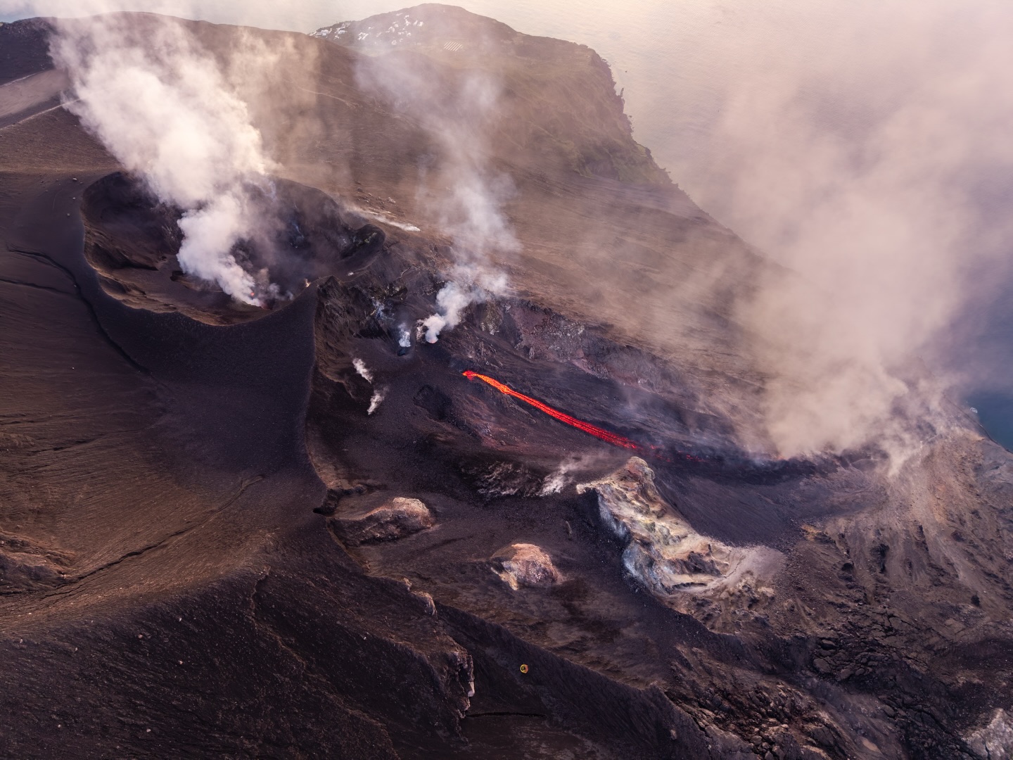
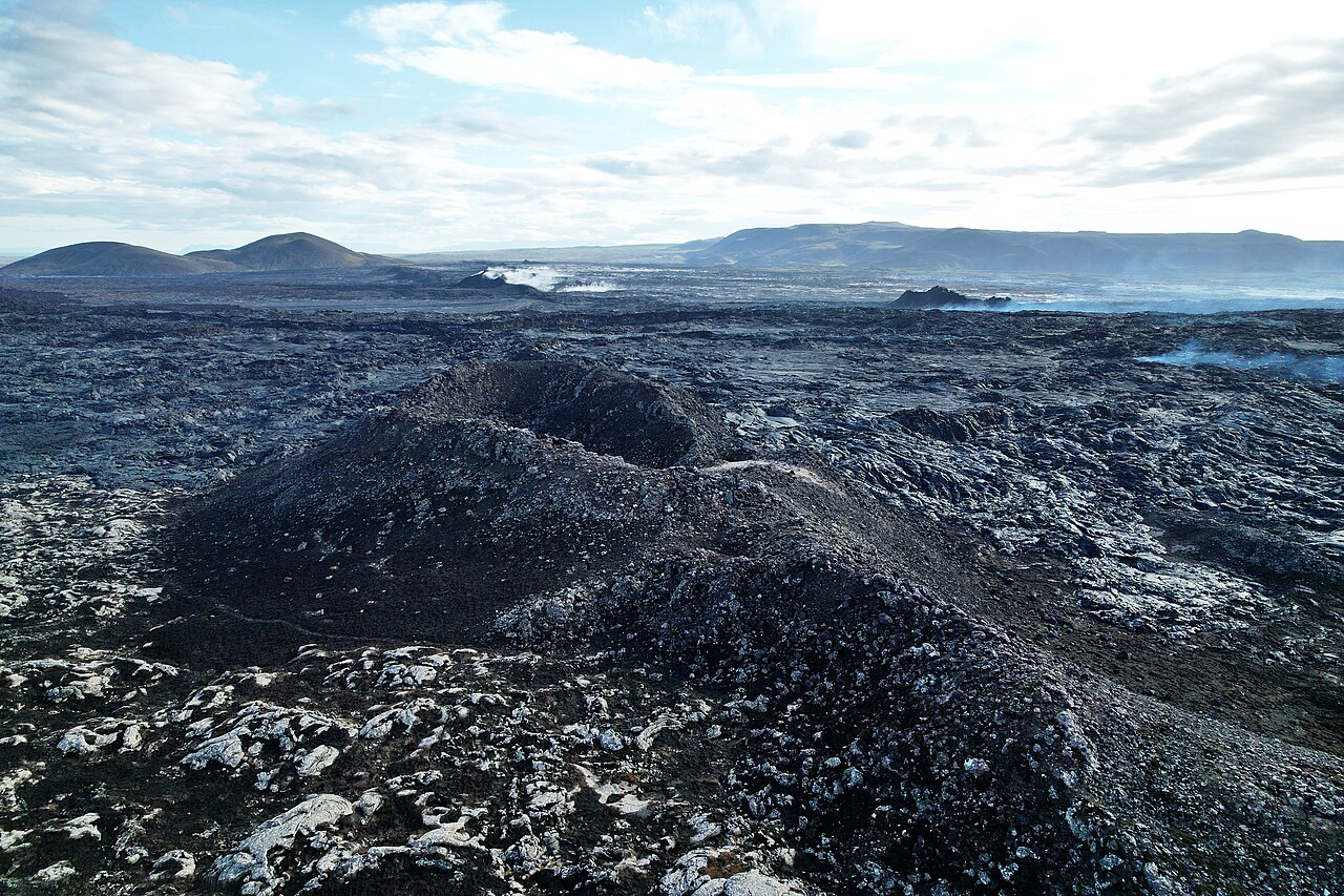
Iceland , Reykjanes Peninsula :
Magma volume beneath Svartsengi has never been greater since the start of the eruption sequence
Updated 31 March
A magma intrusion and eruption on the Sundhnúkur crater row remains the most likely scenario
The greatest magma accumulation between eruptions since the beginning of the eruption sequence
Slow magma accumulation and a long pause between eruptions do not mean that the eruption sequence is over
The hazard assessment is unchanged and remains valid until 30 June
Just over 24 million cubic metres of magma have now accumulated beneath Svartsengi since the last eruption in July of last year. Model calculations indicate that the amount of magma in the magma reservoir beneath Svartsengi has never been higher since the eruption sequence began on the Sundhnúkur crater row in November 2023.
As long as magma accumulation continues, a magmatic intrusion and eruption at the Sundhnúkur crater chain remain the most likely scenario. With the amount of magma beneath Svartsengi now greater than before, the next eruption could be more devastating than previous ones if the magma reaches the surface, either partially or completely.
No signs that the eruption sequence is coming to an end
It is important to keep in mind that slow magma accumulation is not a clear indication that an eruption will not occur. The most immediate example of this is the Krafla Fires eruption sequence from 1975 to 1984.
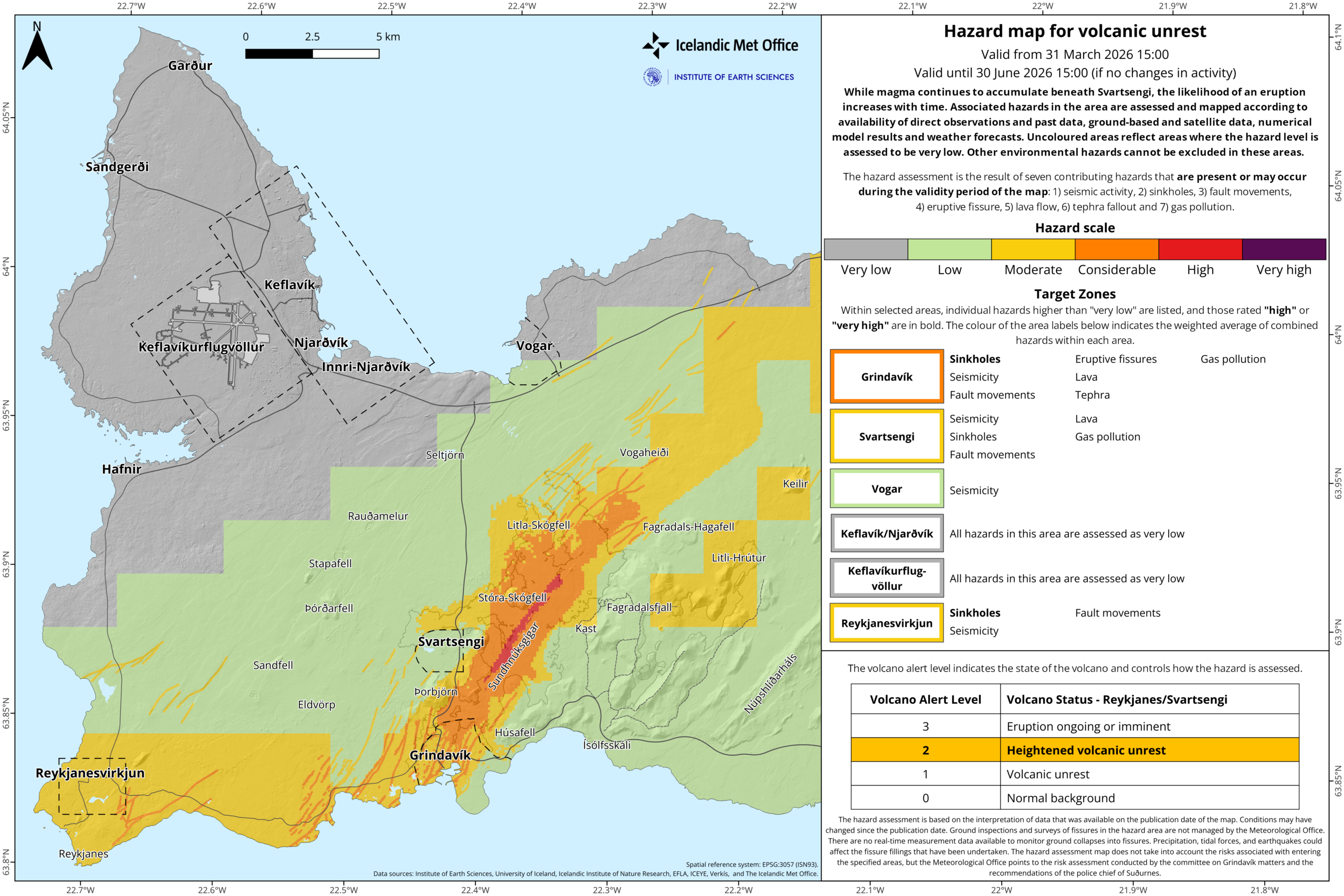
Hazard assessment unchanged. The situation is marked by uncertainty
Model calculations, based in part on measurements of ground uplift, show that the rate of magma accumulation beneath Svartsengi has never been slower. The fact that magma accumulation has never been slower, while the amount of magma beneath Svartsengi has never been greater between eruptions, increases the uncertainty about developments in the area. It is not possible to say when a magma intrusion or eruption will occur, and the timeframe is measured in months.
The hazard assessment is unchanged and remains valid until 30 June unless there are changes in activity. The Icelandic Meteorological Office’s 24/7 monitoring therefore continues to follow the area closely, and in light of the current situation, residents and others in the area need to be prepared for evacuations to be implemented at short notice.
Source : IMO.
Photos : Steinninn , IMO.