April 2 , 2026.
La Réunion Island , Piton de la Fournaise :
Press release from the Paris Institute of Earth Physics, Piton de la Fournaise Volcanological Observatory, April 2, 2026 – 6:30 a.m. local time – 2:30 a.m. UTC
Ongoing eruption
Summary
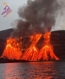
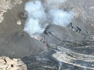
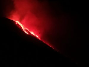
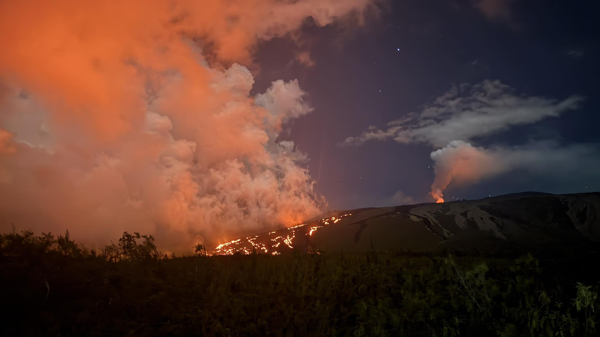
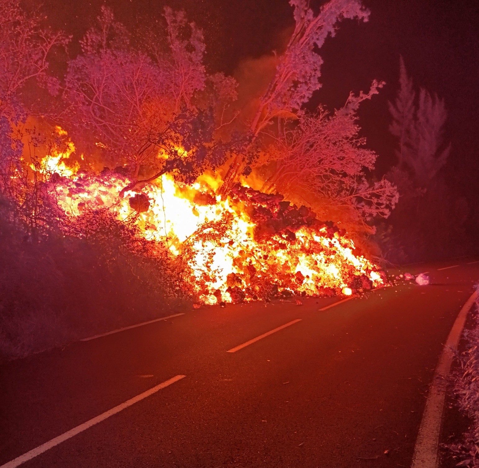
The eruption that began on February 13, 2026, resumed on March 28 at approximately 3:00 p.m. local time. Only one eruptive site is active on the south-southeast flank, at the cone formed between February 13 and March 25. Only the main southern flow is being fed again. Lava tube activity is well-developed with numerous resurgences. Yesterday, April 1, at 9:25 p.m., the RN2 highway
was again cut off by lava, 300 meters further south of the previous cut-off point. Lava flows and overflows are being observed at the eruptive cone. The eruptive tremor (an indicator of lava and gas flow) shows a downward trend over the last 24 hours. Strong seismicity and deflation of the edifice, indicating depressurization of the shallow magma reservoir, are still observed.
Observations at the various sites
After a pause observed between March 25 (4:30 PM local time) and March 28, the eruption that began on February 13, 2026, on the south-southeast flank of the volcano resumed on March 28 around 3:00 PM local time.
At the eruptive site, lava flows are still active inside the cone, and minor lava overflows associated with the rising of gas bubbles are observed. This degassing generally occurs intermittently, resulting in slight bursts of tremor on the observatory’s seismic recordings.
Lava tunnel activity continues downstream of the cone, with numerous resurgences visible in the lava field formed between February 13 and March 25, 2026. These resurgences are clearly visible in the Grandes Pentes area. Only the southern arm of the lava field is currently active along the main flow that reached the sea on March 16, as well as along a secondary arm located south of this main flow. Yesterday, April 1, at 9:25 p.m., the RN2 highway was again cut off by lava, approximately 300 meters further south of the previous cutoff point.
Over the past 24 hours, no resurgence has been observed on the platform, and it did not appear to be receiving any new lava. It should be noted that if the platform were to be replenished, a plume of gas (composed of water vapor, hydrochloric acid (HCl), and fine particles) would form again at the point where the lava enters the ocean, with an intensity depending on the amount of lava reaching the ocean.
This platform, composed of an accumulation of lava flows and rock fragments, remains highly unstable and fragile.
Instrumental Observations
Strong seismicity continues to be recorded, with 70 shallow volcano-tectonic earthquakes on April 1st. These earthquakes are located in the summit area of the volcano, primarily along an annular fault situated directly above the shallow magma reservoir (located approximately 1.5-2 km below the summit area).
Deflation of the summit area continues, indicating depressurization of the shallow magma reservoir, although this depressurization appears to be decreasing in intensity. This parameter will need to be confirmed in the coming days.
The intensity of the eruptive tremor (an indicator of lava and gas flow) shows a downward trend over the last 24 hours, with variations in amplitude likely indicating changes in the intensity of degassing.
Surface flow rates, estimated from satellite data via the HOTVOLC platform (OPGC – Clermont Auvergne University), have decreased over the past 24 hours, with values below 5 m³/s. It should be noted that these estimates can vary significantly depending on cloud cover and become zero in the event of total cloud cover. Current activity in the lava tube also tends to underestimate the flow rates measured by satellite.
Alert Level 2.2
Source : OVPF / IPGP.
Photos : Samuel RBT , Gendarmerie .
United – States , Yellowstone :
YELLOWSTONE VOLCANO OBSERVATORY MONTHLY UPDATE , U.S. Geological Survey
Wednesday, April 1, 2026, 10:30 AM MDT (Wednesday, April 1, 2026, 16:30 UTC)
44°25’48 » N 110°40’12 » W,
Summit Elevation 9203 ft (2805 m)
Current Volcano Alert Level: NORMAL
Current Aviation Color Code: GREEN
Summary
Yellowstone Caldera activity remains at background levels, with 61 located earthquakes in March (largest = M1.9). Deformation measurements indicate a pause in the uplift that had been occurring along the north caldera rim since July 2025.
Recent Work and News
Echinus Geyser, in Norris Geyser Basin, reawakened from a several-year slumber in February, with about 40 eruptions that month, but the geyser had only one eruption in March. An eruption was detected by acoustic, seismic, and temperature measurements at Black Diamond Pool in Biscuit Basin (site of a hydrothermal explosion in 2024) on March 9 at 1:27 a.m. MDT.
Seismicity
During March 2026, the University of Utah Seismograph Stations, responsible for the operation and analysis of the Yellowstone Seismic Network, located 61 earthquakes in the Yellowstone National Park region. The largest event of the month was a microearthquake of magnitude 1.9 located about 5 miles north of West Yellowstone, Montana, on March 15 at 5:14 a.m. MDT.
March seismicity in Yellowstone was marked by a swarm of 10 earthquakes that occurred approximately 5 miles north of West Yellowstone, Montana, on March 15. The largest earthquake in the sequence was also the largest in March (described above).
Earthquake activity in Yellowstone is at background levels.
Ground Deformation
Continuous GPS stations indicate that the uplift that started in July 2025 on the north caldera rim ceased by mid-January 2026. In Yellowstone Caldera, continuous GPS data recorded little net change since December, although results are ambiguous due to the impacts of winter weather conditions on GPS data.
Source : YVO
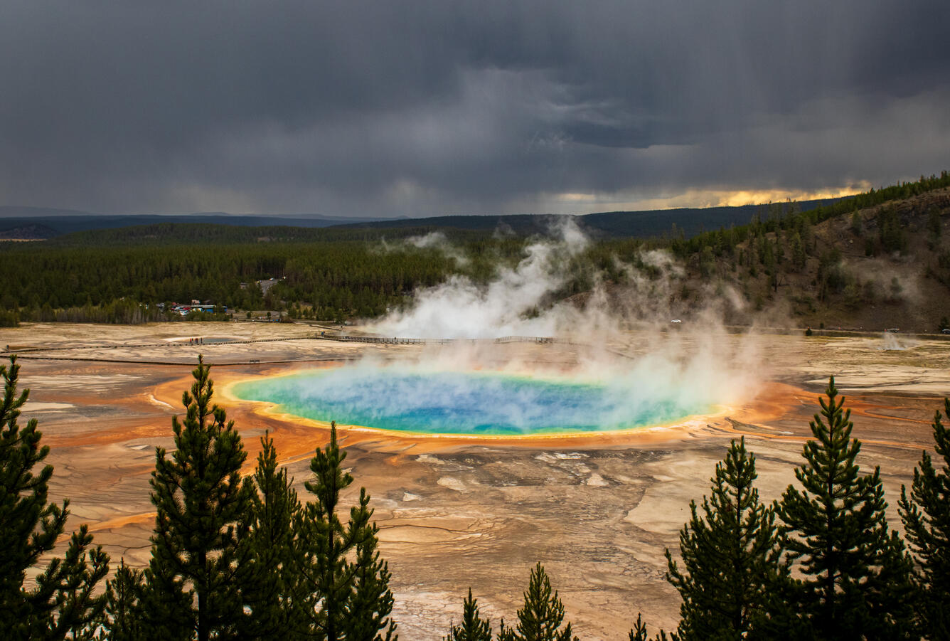
Photo : USGS , 10/2023Grand Prismatic Spring.
Indonesia , Dukono :
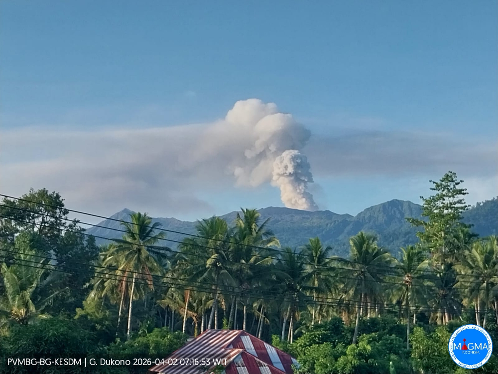
Mount Dukono experienced an eruption on Thursday, April 2, 2026 at 11:22 a.m. (local time). An ash column was observed approximately 1,500 meters above the summit (at an altitude of about 2,587 meters). This ash column, white to gray in color, was highly concentrated and extended to the southeast. At the time of writing, the eruption was still ongoing.
VOLCANO OBSERVATORY NOTICE FOR AVIATION – VONA
Issued : April 2 , 2026
Volcano : Dukono (268010)
Current Aviation Colour Code : ORANGE
Previous Aviation Colour Code : yellow
Source : Dukono Volcano Observatory
Notice Number : 2026DUK012
Volcano Location : N 01 deg 41 min 35 sec E 127 deg 53 min 38 sec
Area : North Maluku, Indonesia
Summit Elevation : 3478 FT (1087 M)
Volcanic Activity Summary :
Eruption with volcanic ash cloud at 02h22 UTC (11h22 local).
Volcanic Cloud Height :
Best estimate of ash-cloud top is around 8278 FT (2587 M) above sea level or 4800 FT (1500 M) above summit. May be higher than what can be observed clearly. Source of height data: ground observer.
Other Volcanic Cloud Information :
Ash cloud moving to southeast. Volcanic ash is observed to be white to gray. The intensity of volcanic ash is observed to be thick.
Remarks :
Eruption and ash emission is continuing. Eruption recorded on seismogram with maximum amplitude 24 mm. Tremor recorded on seismogram with maximum amplitude 4 mm.
Source et photo : PVMBG.
Colombia , Chiles / Cerro Negro :
San Juan de Pasto, March 31, 2026, 3:00 PM
Regarding the monitoring of activity at the Chiles-Cerro Negro Volcanic Complex (CVCCN), the Colombian Geological Survey (SGC), an agency under the Ministry of Mines and Energy, reports the following:
During the period from March 24 to 30, 2026, the main variations in monitored parameters compared to the previous week were as follows:
● An increase was recorded, doubling the daily frequency and the seismic energy released compared to the previous week. Seismicity due to rock fracturing predominated, followed by signals related to fluid dynamics in volcanic conduits. The events were concentrated mainly south and southwest of the Chiles volcano and east of the Cerro Negro volcano, within a 3 km radius and at depths ranging from 0.1 to 10 km from the summit of Chiles volcano (4,700 m altitude). The earthquake of March 27 at 9:49 a.m. was particularly noteworthy: with a magnitude of 3.9 ML, at a depth of 3.3 km, 1.8 km to the west, it was felt by the inhabitants of Cumbal.

Data collected by satellite sensors and ground stations continue to record surface variations consistent with deformation processes in certain areas of the volcanic zone of influence.
Based on the assessment and correlation of monitored parameters, the Geological Survey of Colombia (SGC) recommends closely monitoring the evolving situation by referring to weekly bulletins and other information published through its official channels, as well as instructions from local and departmental authorities and the National Unit for Disaster Risk Management (UNGRD).
Volcanic activity remains at the yellow alert level: active volcano with changes in the baseline behavior of monitored parameters and other manifestations.
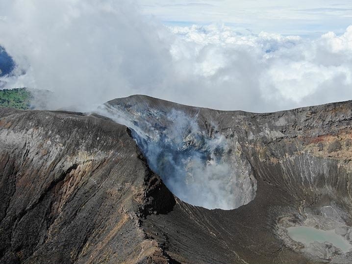
Source et photo : SGC.
Costa Rica , Turrialba :
Latitude: 10.02°N;
Longitude: 83.76°W;
Altitude: 3325 m
Current Activity Level: Alert.
Volcano-seismic activity has remained stable, with the number of long-period (LP) earthquakes not exceeding 10 per day since February 2026. A slight increase in earthquakes with coda-tonal activity has been observed in recent days (10 events), along with a few discrete two-phase events. On March 22 at 12:03 local time, seismographs and infrasound acoustic sensors recorded a volcano-tectonic earthquake of type VT, followed one minute later by a rockfall in a sector of the volcanic edifice. The epicenter was located approximately within the volcanic edifice, below the summit area.
The geodetic network records a slight contraction of the Irazú-Turrialba massif, but no significant vertical movement is detected, except around the crater. The MultiGAS station indicates a stable gas composition, with an H₂S/SO₂ ratio close to 0.4. This week, DOAS stations recorded an average SO₂ flux of approximately 50 t/d, with a maximum value of 150 t/d. Since October 2025, the European SENTINEL satellite has not detected any SO₂ mass exceeding 30 tonnes.
Source : Ovsicori .
Photo : G. Avard / Ovsicori