April 16 , 2026.
La Réunion Island , Piton de la Fournaise :
Press release from the Paris Institute of Earth Physics / Piton de la Fournaise Volcanological Observatory, April 15, 2026 – 8:30 a.m. local time – 4:30 a.m. UTC
Tremor
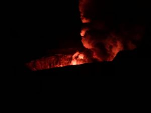
Tremor* has been recorded since approximately 3:00 p.m. (local time, 11:00 a.m. UTC) on April 14. The source of this tremor is located on the east-southeast flank of the volcano and is positioned in the same location as during the eruptive activity phases from February 13 to April 12.
Last night (between 6:30 p.m. and 10:00 p.m. local time), a rapid increase in tremor was observed. No surface lava emissions were detected in the images from the observatory’s cameras during this period.
Since then, a residual, low-intensity tremor has continued to be recorded.
Currently, only degassing is observed at the eruptive sites associated with the activity from February 13 to April 12, located at an altitude of 2056-2120 m on the east-southeast flank of the volcano.
This tremor nevertheless indicates the presence of magma at shallow depths; thus, a resumption of lava flows cannot be ruled out.
Last night, a glowing, incandescent point was observed at the summit of the eruptive cone, in the area of the most intense degassing on the cone formed between April 9 and 12. This incandescent point did not originate from lava ejecta and was already present the previous day. However, it is certain that very high-temperature material, potentially even molten, still resides inside the cone.
Seismicity
Since the cessation of surface eruptive activity on April 12 at 11:10 p.m. (local time), seismicity beneath the summit remains low.
Deformation
Slight asymmetric deformation of the summit is currently being recorded. This parameter will be confirmed in the coming days.
*Volcanic tremor: a near-continuous seismic signal associated with the circulation of magmatic and/or gaseous fluids within the volcanic edifice. Its source mechanisms can include fluid flow, flow instabilities, and the resonance of fluid-filled conduits or fractures.
Press release from the Paris Institute of Earth Physics / Piton de la Fournaise Volcanological Observatory, April 15, 2026 – 2:30 PM local time – 10:30 AM UTC
Tremor ceased
Since 11:20 AM local time, the residual tremor that had been recorded since its resumption on April 14 at 3:00 PM local time has disappeared from the observatory’s seismological records.
At this stage, a resumption of tremor, as well as a resumption of the eruption, in the coming days cannot be ruled out.
Slight degassing is still being observed at the eruptive sites associated with the activity from February 13 to April 12, located at an altitude of 2056-2120 m on the east-southeast flank of the volcano.
Source : OVPF-IPGP
Photo : Cynthia Veron .
Indonesia , Dempo :
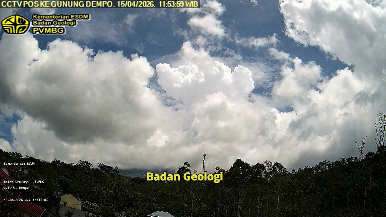
DEMPO VOLCANO ERUPTION, SOUTH SUMATRA, APRIL 15, 2026, 11:45 AM WIB
Dempo Volcano is an active stratovolcano located in the province of South Sumatra. Its elevation is 3,173 meters. Volcanic activity is currently concentrated in the Marapi crater.
On April 15, 2026, at 11:45 AM WIB, Dempo Volcano erupted. A thick, white eruptive column, dipping to the northeast, was observed, reaching an elevation of approximately 3,500 meters above the summit (approximately 5,673 meters above sea level). This eruption was recorded on a seismogram with a maximum amplitude of 30 mm and a duration of approximately 13 minutes and 49 seconds.
Seismicity monitoring from 1 to 14 April 2026 recorded one eruption earthquake, two low-frequency earthquakes, one shallow volcanic earthquake, four deep volcanic earthquakes, three local tectonic earthquakes, one earthquake felt on the MMI II scale, 15 distant tectonic earthquakes and continuous tremors of amplitudes between 0.5 and 1 mm (mainly 0.5 mm).
Observations of Mount Dempo’s deformation using an inclinometer from the Tugu Rimau station showed a trend toward inflation before the eruption of April 2, 2026, followed by stabilization without significant change until the eruption of April 15, 2026. This indicates subsurface instability, which could lead to an eruption at any time, without any apparent warning signs according to monitoring data.
Visual monitoring of Mount Dempo from April 1 to 14, 2026, revealed that the volcano was clearly visible until it became obscured by fog, and no crater smoke was observed. The weather was sunny with showers, accompanied by light to moderate winds.
The eruption of Mount Dempo is phreatic, meaning it can occur suddenly, without any warning signs. Analysis of visual and instrumental data allows us to assess the activity level of the Dempo volcano at level II (WASPADA). The public, visitors, and tourists are advised not to approach or spend the night near the center of activity, namely the Marapi crater, within a radius of 1 km and in the direction of the crater opening up to 2 km to the north, due to the risk of being hit by ejecta from phreatic eruptions and the risk of volcanic gases that are dangerous to life.
Source et photo : PVMBG.
Colombia , Chiles / Cerro Negro :
San Juan de Pasto, April 14, 2026, 4:50 PM
Regarding the monitoring of activity at the Chiles-Cerro Negro Volcanic Complex (CVCCN), the Colombian Geological Survey (SGC), an agency under the Ministry of Mines and Energy, reports the following:
For the period from April 7 to 13, 2026, the main variations in monitored parameters, compared to the previous week, were as follows:
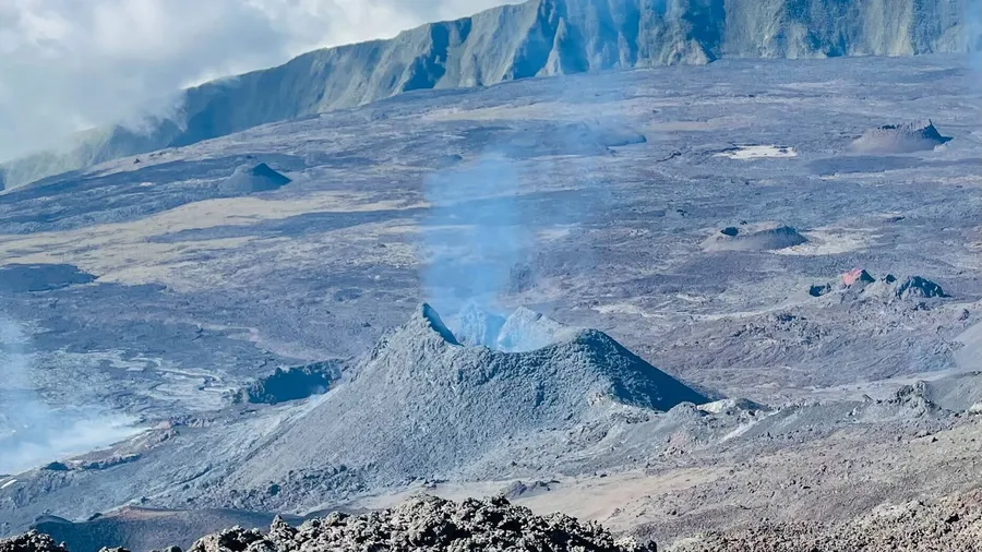
● In a context of fluctuating seismic activity, the downward trend in the number of earthquakes continued; however, the energy released increased, primarily due to the contribution of two significant earthquakes of magnitude 2.7 and 2.8. The predominant seismicity remained associated with rock fracturing processes, followed by that related to fluid dynamics.
Most of the earthquakes occurred near the Chiles volcano, both within the collapse zone and to its east, south, and west, at distances of up to 3.4 km and depths of between 1.2 and 5.2 km from the volcano’s summit (4,700 m above sea level). During this period, two fracture earthquakes stood out: the first, with a magnitude of 2.7, occurred on April 8 at 9:58 a.m., 2.3 km west of the Chiles volcanic edifice, at a depth of 4.5 km; the second, with a magnitude of 2.8, was recorded on April 13 at 7:20 a.m., directly below the summit of the volcanic edifice. Neither of these events was felt by the population living within the volcano’s sphere of influence.
Analysis of data collected by satellite sensors and ground stations continued to reveal variations related to deformation processes in the volcanic zone.
Based on the assessment and correlation of monitored parameters, the Geological Survey of Colombia (SGC) recommends closely monitoring its evolution through weekly bulletins and other information published via its official channels, as well as following instructions from local and departmental authorities and the National Unit for Disaster Risk Management (UNGRD).
Volcanic activity remains at the yellow alert level: active volcano exhibiting changes in the reference behavior of monitored parameters and other manifestations.
Source et photo : SGC.
Hawaii , Kilauea :
HAWAIIAN VOLCANO OBSERVATORY DAILY UPDATE, U.S. Geological Survey
Wednesday, April 15, 2026, 7:48 AM HST (Wednesday, April 15, 2026, 17:48 UTC)
19°25’16 » N 155°17’13 » W,
Summit Elevation 4091 ft (1247 m)
Current Volcano Alert Level: ADVISORY
Current Aviation Color Code: YELLOW
Overview:
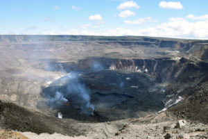
The Halemaʻumaʻu eruption of Kīlauea is paused. Summit inflation is underway at this time, while glow and flames have been visible at south vent over the past day. Forecast models suggest that lava fountaining episode 45 will occur sometime between Sunday, April 19 and Saturday, April 25. Most Kīlauea monitoring data streams are operational again after HVO’s radio telemetry network was restored yesterday afternoon.
No significant activity has been noted along Kīlauea’s East Rift Zone or Southwest Rift Zone.
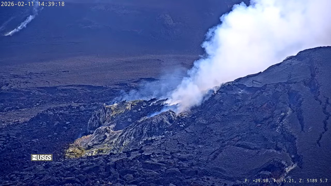
Summit Observations:
Overnight, glow was consistently visible at the Halemaʻumaʻu south vent, along with several periods of intense flaming—likely caused by the ignition of volcanic gases escaping the vent. No such activity was apparent at the north vent, but it has continued to emit volcanic gases.
Low-level seismic tremor continues during the ongoing eruptive pause, with bursts approximately every 10 minutes likely associated with gas pistoning cycles in the north and south vents.
Since the end of lava fountaining episode 44 on April 9, the Uēkahuna tiltmeter (UWD) has tracked approximately 10.1 microradians of inflationary tilt. This instrument recorded 17.6 microradians of deflationary tilt in total during the episode.
With the eruption paused, the sulfur dioxide (SO2) emission rate from Halemaʻumaʻu is likely now varying within a typical range of 1,000 to 5,000 tonnes per day. Winds near the eruptive vents have been directionally variable over the past day.
Rift Zone Observations:
Rates of seismicity and ground deformation remain low in the East Rift Zone and Southwest Rift Zone. SO2 emissions from the East Rift Zone remain below the detection limit.
Source et photo : HVO.
Costa Rica , Turrialba :
Latitude: 10.02°N;
Longitude: 83.76°W;
Altitude: 3325 m.
Current activity level: Alert.
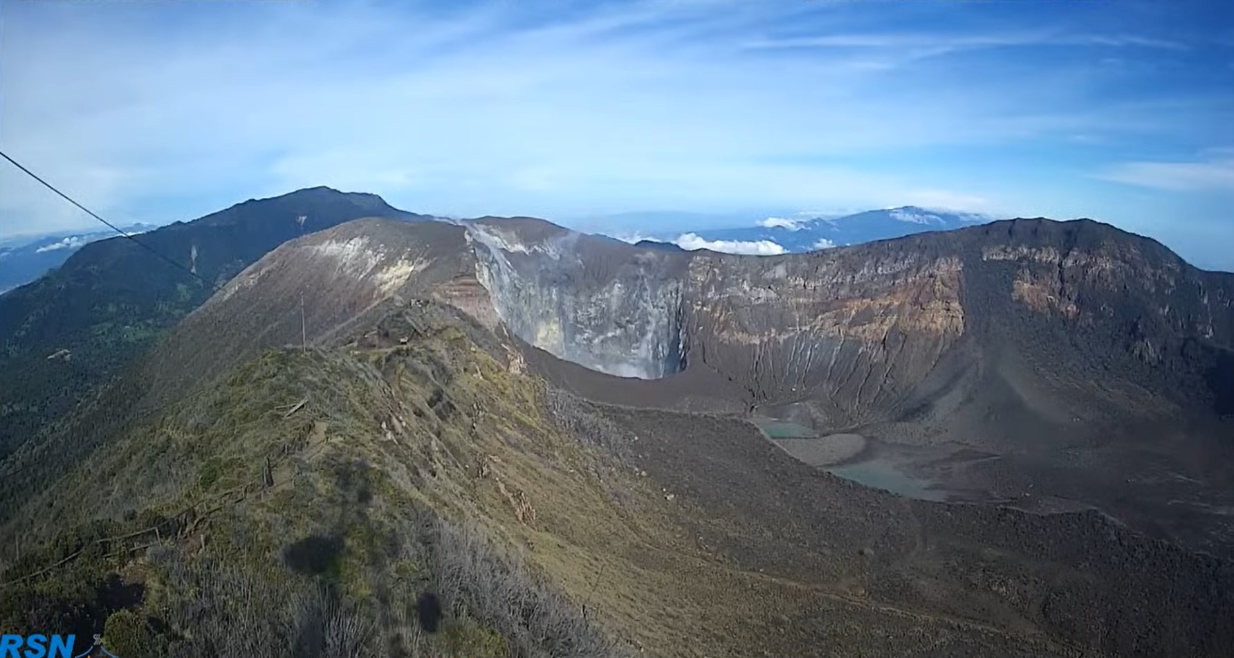
Seismic activity remains stable. The geodetic network is recording a slight contraction of the Irazú-Turrialba massif, but no movement has been detected. This week, DOAS stations recorded an average SO₂ flux of 76 ± 57 t/d, slightly higher than the previous week (31 ± 10 t/d).
In recent weeks, the SENTINEL satellite has detected SO₂ concentrations in the atmosphere at a frequency not seen since 2022, but the values remain relatively low, with a maximum of 21.3 tonnes on April 7.
Source : Ovsicori.
Photo : RSN.