September 9 , 2026.
Hawaii , Kilauea :
HAWAIIAN VOLCANO OBSERVATORY DAILY UPDATE , U.S. Geological Survey
Tuesday, September 8, 2026, 8:38 AM HST (Tuesday, September 8, 2026, 18:38 UTC)
19°25’16 » N 155°17’13 » W,
Summit Elevation 4091 ft (1247 m)
Current Volcano Alert Level: WATCH
Current Aviation Color Code: ORANGE
Summary:
Kīlauea volcano is not erupting; the summit eruption in Halemaʻumaʻu is paused. Precursory overflows started yesterday afternoon, but stopped overnight during summit deflation. A forecast window of September 8-10 is likely for the start of episode 55.
Overview:
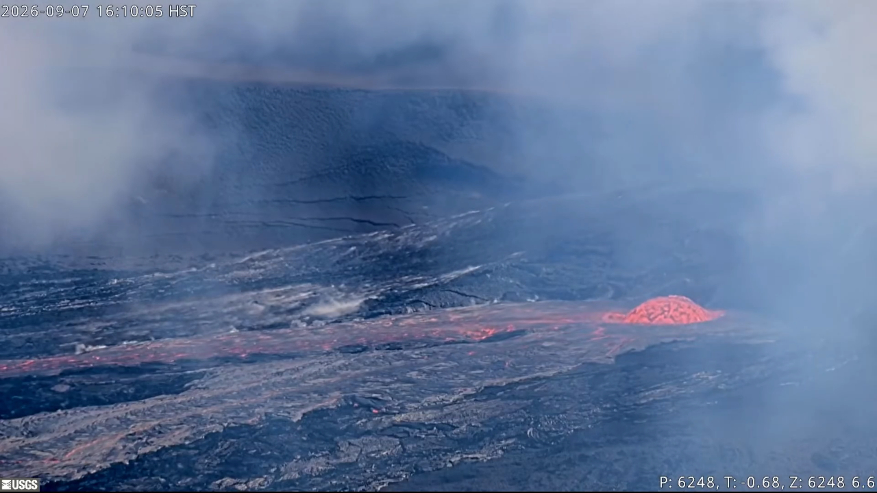
The summit eruption of Kīlauea in Halemaʻumaʻu is paused. Yesterday at 12:45 p.m. HST precursory overflows started from the north vent, which prompted the alert level to be raised to ORANGE and WATCH. A total of 10 overflows have occurred with the last ending at 1:23 a.m. HST this morning. Their are two lava flow lobes formed during these overflows that have made it around a half a mile (a kilometer) from the north vent. Moderate glow has been seen from the vents since overflows stopped, but heavy rain and steam have obscured most webcam views. Gas piston activity at 5 minute intervals that started around 7:30 p.m. HST Sunday night before the overflows continues this morning. Summit reinflation has been very irregular since lava fountaining episode 54 on August 25. Inflation briefly reached higher than that when episode 54 began but is currently around 0.5 microradians below the episode 54 starting level. A forecast window of September 8-10 is likely for the next episode if inflation resumes and follows the prior patterns.
No significant activity has been noted along Kīlauea’s East Rift Zone or Southwest Rift Zone.
Summit Observations:
Webcam views have been mostly obscured by heavy rain, clouds, and steam from Hurricane Lowell passing west of the Hawaiian Islands. Precursory overflows from the north vent started yesterday at around 12:45 p.m. HST. There have been 10 overflows from the north vent that have lasted from 16 minutes to 1 hour and 32 minutes long, separated by interludes of 29 to 44 minutes. The last north vent overflow ended at 1:23 a.m. HST this morning. The first overflow produced a very sluggish lava flow with no dome fountain. Subsequent overflows produced more vigorous flows fed by a dome fountain that reached 15-30 ft (5-10 m) tall. Two main lava flows have formed during these overflows with one making it about a half mile (1 kilometer) to the southwest of the north vent, and the other making it less than half a mile (1 kilometer) to the northeast of the north vent. After the overflows ended early this morning, occasion moderate glow was observed from the north vent when it was not obscured by rain and steam. No overflows occurred from the south or west vents, but occasion glow and flames were noted from these vents overnight.
Tremor continues across the summit with regular intervals (about 5 minutes) of gas piston activity. In the absence of views from webcams into the vents during overflow activity, changes in tremor signal were used to time the duration of many of the overflows from the north vent. This was noted as a drop in tremor base level during overflows, with that base level slightly increasing after an overflow ended. Eleven small earthquakes were recorded beneath the summit region, including the south caldera region, over the past 24 hours.
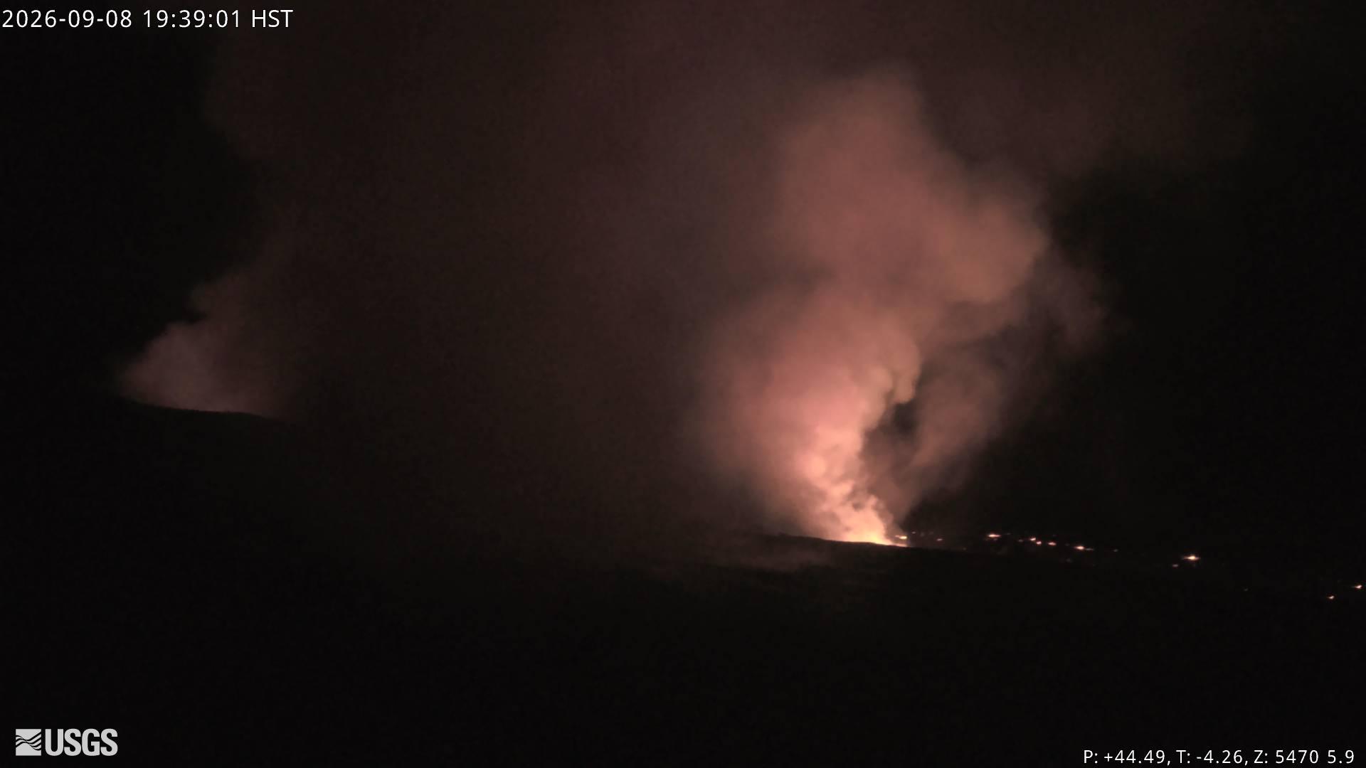
Summit reinflation has been very unsteady since lava fountaining episode 54 on August 25. On Monday around 3:00 p.m. HST, inflation at UWD reached approximately 13.2 microradians of post-episode 54 recovery. Since this inflationary high, UWD has since lost around 1 microradian and subsequently recovered about 0.5 microradians. As of this morning, UWD is at approximately 12.3 out of the 12.7 microradians lost during episode 54.
During inter-episode pauses, the sulfur dioxide (SO2) emission rate from the summit typically varies between 1,000 and 5,000 tonnes per day. Trade winds continue to be weak this morning and the degassing plume is being pushed towards public overlooks along the north and northeast rims of Kīlauea’s summit caldera. South winds are expected to pick up later this morning and could blow volcanic gases as well as fine ash and Peleʻs hair if episode 55 starts, toward the north side of Kaluapele and towards downwind communities.
Rift Zone Observations:
Rates of seismicity and ground deformation remain low in the East Rift Zone and Southwest Rift Zone. SO2 emissions from the East Rift Zone remain below the detection limit.
Source et photos : HVO.
Alaska , Kupreanof :
AVO/USGS Volcanic Activity Notice
Current Volcano Alert Level: ADVISORY
Current Aviation Color Code: YELLOW
Issued: Tuesday, September 8, 2026, 2:20 PM AKDT
Source: Alaska Volcano Observatory
Notice Number: 2026/A686
Location: N 56 deg W 159 deg 47 min
Elevation: 6217 ft (1895 m)
Area: Alaska Peninsula
Summary:
Volcanic activity at Mount Kupreanof has declined to background levels.
Volcanic Activity:
The number of earthquakes, intensity of steam emissions, and measured sulfur dioxide emissions beneath Mount Kupreanof have declined. Due to these changes, the Alaska Volcano Observatory is lowering the Aviation Color Code and the Volcano Alert Level to UNASSIGNED.
Summary of activity and hazards
Seismicity was first detected in February 2026 and increased over the following months, with earthquakes as large as magnitude 3.1 recorded. However, seismicity has declined over the past month.
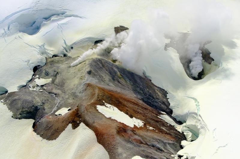
Sulfur dioxide (SO2) emissions were detected beginning on April 4 with emission rates of ~100 to 1,000 tons per day, which are well above the background rate of <100 tons per day. These have dropped to background levels since late August.
Collectively, these data likely indicate the magmatic intrusion beneath Mount Kupreanof has stalled.
Remarks:
Mount Kupreanof is a heavily glaciated stratovolcano on the Alaska Peninsula with no known historical eruptions. Very little is known about its eruptive history. A single debris flow or block-and-ash flow deposit with a suspected Holocene age has been mapped in a valley south of the volcano. Eruptions will likely produce lahars and pyroclastic flows on the volcano’s flanks and into the surrounding uninhabited valleys. Ash plumes could affect communities and airplanes downwind of the volcano. A vigorous fumarole field just west of the summit produces persistent steam plumes.
A new temporary monitoring station was installed near Mount Kupreanof this past summer (2026) and is providing seismic data, infrasound data, gas measurements, and web camera images on an intermittent basis. This is by design to conserve battery power, but the frequency of data acquisition can be increased if activity warrants. The closest functioning seismometers that provide continuous data are approximately 10 miles (16 km) to the northeast of the volcano as part of the Mount Veniaminof network. Mount Kupreanof is also monitored by satellite data, remote infrasound and lightning networks, and visual observations from pilots and mariners passing by the volcano.
Source : AVO
Photo : Loewen, M. W / AVO / USGS .
Italy / Sicily , Etna :
WEEKLY BULLETIN, August 31, 2026 – September 6, 2026 (Date of issue: September 8, 2026)
ACTIVITY SUMMARY
Based on monitoring data, the observations are as follows:
1) VOLCANOLOGICAL OBSERVATIONS: Variable degassing activity at the summit craters, associated with near-continuous ash emissions from the Northeast Crater; low-level Strombolian activity and sporadic ash emissions from the Bocca Nuova crater.
2) SEISMOLOGY: Absence of seismic activity related to fracturing with magnitude Ml ≥ 2.0. Tremor amplitude ranged between low and moderate levels.
3) INFRASOUND: Infrasonic activity was predominantly low, with occasional increases.
4) GROUND DEFORMATION: Signals from ground deformation monitoring networks showed no significant variation over the past week.
5) GEOCHEMISTRY: SO2 flux at a moderate level.
Soil CO2 flux (Etnagas network): low to moderate values.
Partial pressure of dissolved CO2 in groundwater (EtnaAcque network): no update.
Helium (He) isotope ratio at peripheral sites: no update; the last recorded value was high (August 26, 2026).
6) SATELLITE OBSERVATIONS: Thermal activity in the summit area observed by satellite was generally low, with isolated anomalies of moderate intensity.
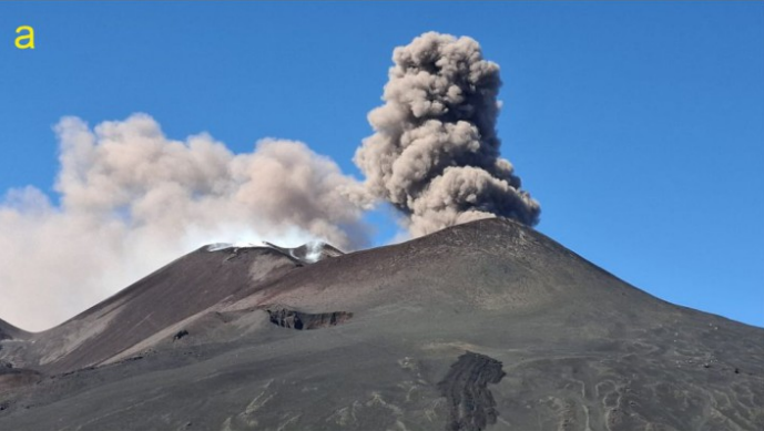
Pulsatory ash emissions from the Northeast Crater, viewed from the Pizzi Deneri Observatory on September 4, 2026.
VOLCANOLOGICAL OBSERVATIONS
During the week of August 31 to September 6, monitoring of Etna’s volcanic activity was conducted through the analysis of images from the National Institute of Geophysics and Volcanology – Etna Observatory (INGV-OE) surveillance camera network, as well as through field inspections of the summit area carried out by INGV-OE personnel on September 2, 4, and 6.
During this period, activity at Etna was characterized by variable degassing at the summit craters and ash emissions from the Northeast Crater, which intensified between September 1 and 2.
These emissions occurred in pulses, with puffs rising several hundred meters above the crater. During the inspections on September 2 and 4, moderate Strombolian activity was also observed at BN1; on the latter date, the activity intensified, ejecting lava fragments beyond the vent rim. From September 5 onwards, this activity shifted to sporadic ash emissions. Conversely, ash emissions from the Northeast Crater decreased starting on September 6.
Source et photo : INGV
Italy , Stromboli :
WEEKLY BULLETIN, August 31, 2026 – September 6, 2026 (issue date: September 8, 2026)
ACTIVITY SUMMARY
Based on monitoring data, the observations are as follows:
1) VOLCANOLOGICAL OBSERVATIONS: Ordinary Strombolian eruptive activity at both crater zones. The frequency of total explosive activity—including the North Crater zone and the Central-South Crater zone—is at a moderate level, with low explosion intensity in the North Crater zone and low intensity in the Central-South zone.
2) SEISMOLOGY: Monitored seismic parameters show no significant variations.
3) GROUND DEFORMATION: Signals from ground deformation monitoring networks show no significant variations.
4) GEOCHEMISTRY: SO2 flux at a moderate level.
Soil CO2 flux (Pizzo zone – STR02): no recent data available.
C/S ratio in the plume: no recent data available.
Helium isotope ratio (R/Ra): no recent data available.
Soil CO2 flux in the San Bartolo zone: high values.
Soil CO2 flux in the Scari zone: no recent data available.
5) SATELLITE OBSERVATIONS: Thermal activity observed by satellite in the summit area was generally at a low to moderate level.
VOLCANOLOGICAL OBSERVATIONS
Observations of explosive activity captured by surveillance cameras
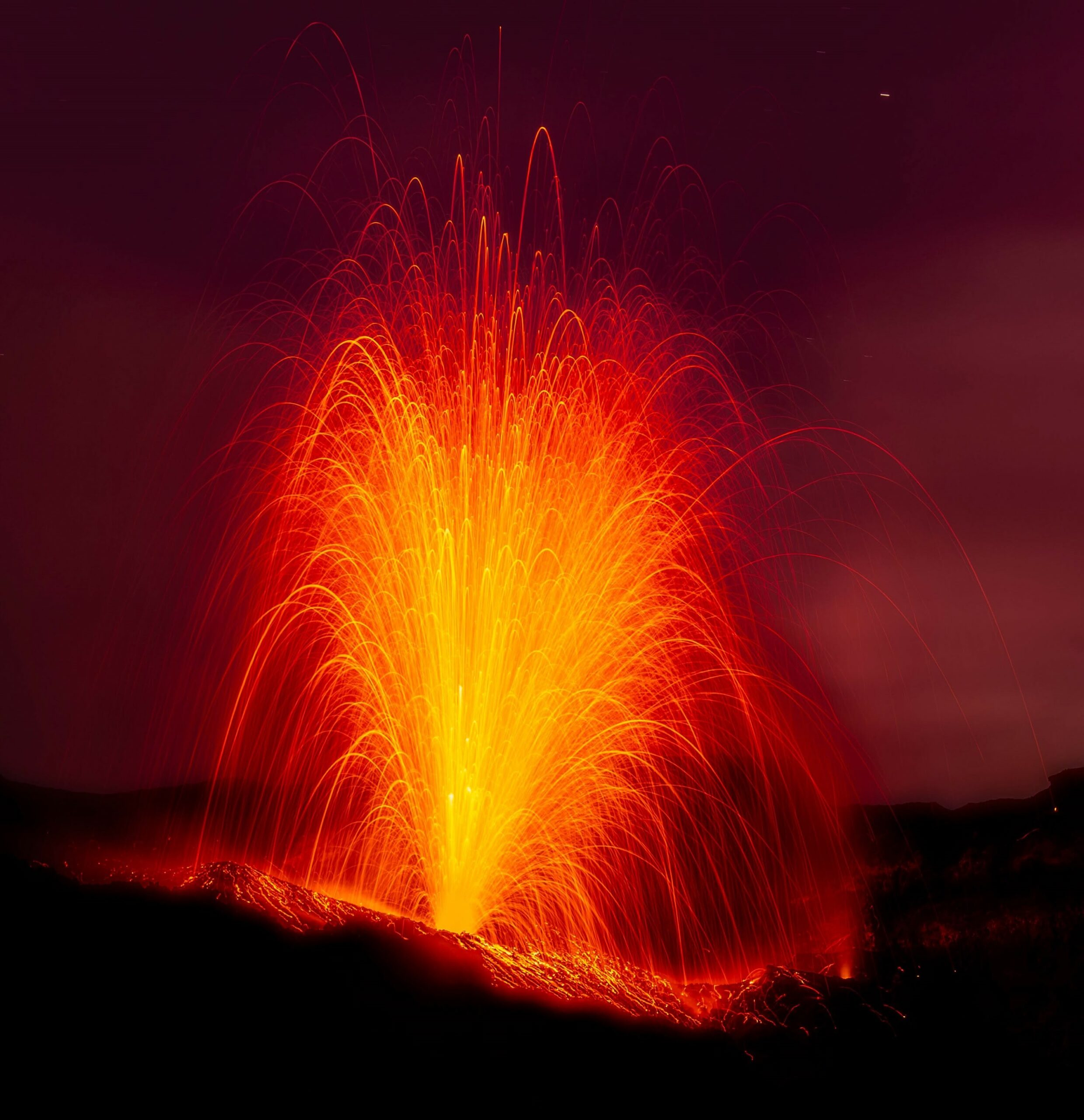
During the observation week, Stromboli’s eruptive activity was characterized through the analysis of images recorded by INGV-OE surveillance cameras located at an elevation of 190 m above sea level and at Punta dei Corvi (SCT-SCV and SPCT, respectively). Explosions in the North crater area (Zone N) primarily produced coarse material (bombs and lapilli), whereas explosions in the Central-South crater area (Zone CS) produced predominantly fine material mixed with coarse material. The average explosion frequency for Zone N fell within a medium range, and intensity remained at an overall low level. In Zone CS, the average explosion frequency was at a medium-low level, and the intensity of explosive activity was generally low. The total average hourly explosion frequency (Zone N + Zone CS) was at a medium level.
Source : INGV
Photo : Stromboli stati d’animo / Sebastiano Cannavo.
Indonesia , Ili Lewotolok :
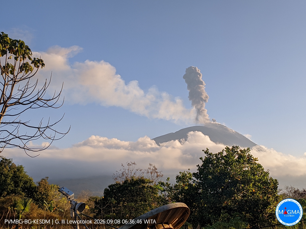
An eruption of Mount Ili Lewotolok occurred on Tuesday, September 8, 2026, at 06:35 WITA, producing an ash column estimated to reach approximately 800 m above the summit (or about 2,223 m above sea level). The observed ash column was gray and dense, and drifted westward. The eruption was recorded by the seismograph with a maximum amplitude of 40 mm and a duration of 180 seconds.
Seismic observations
442 eruption earthquakes (amplitudes: 33.2–40 mm; durations: 22–150 seconds).
60 emission earthquakes (amplitudes: 5.5–22.1 mm; durations: 25–56 seconds).
1 episode of harmonic tremor (amplitude: 11.1 mm; duration: 102 seconds).
5 episodes of non-harmonic tremor (amplitudes: 2.2–40 mm; durations: 96–286 seconds).
2 distant tectonic earthquakes (amplitudes: 22.1–40 mm; durations: 62–146 seconds).
Recommendations
1. Local residents, as well as visitors, climbers, and tourists, must not enter or conduct activities within a 2 km radius—extending to 3 km in the southern and southeastern sectors—of the active center of Mount Ili Lewotolok.
2. Remain vigilant regarding potential hazards such as lava avalanches/rockfalls and pyroclastic flows in the southern, southeastern, western, and northeastern sectors of Mount Ili Lewotolok.
Source et photo : PVMBG.