September 3 , 2026.
Indonesia , Sinabung :
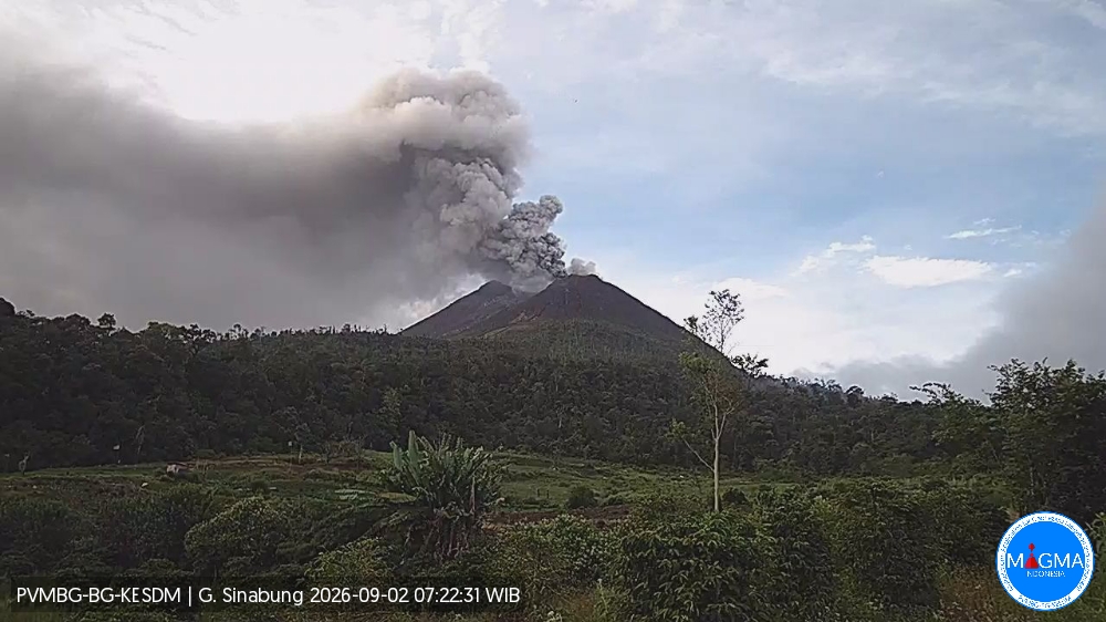
An eruption of Mount Sinabung occurred on Wednesday, September 2, 2026, at 07:20 (Western Indonesia Time), with an ash column reaching a height of approximately 1,000 meters above the summit (or about 3,460 meters above sea level). This dense, gray-to-brown column was moving towards the east and southeast. At the time of writing this report, the eruption was still ongoing.
Seismic observations
1 low-frequency earthquake with an amplitude of 3 mm and a duration of 14 seconds.
1 hybrid/multiphase earthquake with an amplitude of 4 mm and a duration of 12 seconds.
1 episode of continuous tremor with an amplitude of 2–3 mm (dominant amplitude of 2 mm).
Recommendations
1. Residents and visitors/tourists are advised not to engage in activities in villages that have already been evacuated, nor within a 3 km radius of the Mount Sinabung summit, or within a 6 km radius in the southeast sector.
2. Residents living near watercourses originating from Mount Sinabung must remain vigilant regarding the risk of lahars.
3. The Karo Regency government must maintain constant coordination with the Center for Volcanology and Geological Hazard Mitigation (PVMBG) or the Mount Sinabung volcano observation post.
Source et photo : PVMBG.
New Zealand , White Island :
Lower gas emissions observed at Whakaari/White Island.
Published: Thu Sep 3 2026 11:00 AM
Volcanic Alert Level remains at 2
Aviation Colour Code remains at Yellow
The general decline in gas emission observed since December 2024 at Whakaari/White Island has continued over the past two months. No eruptive activity has been observed since March, and the overall level of volcanic activity remains unchanged. The Volcanic Alert Level remains at 2 and the Aviation Colour Code at Yellow.
Since our last bulletin on 23 June 2026, gas emissions have fluctuated between measurement flights but continue to show an overall decline in SO2 emissions observed since December 2024. Between 17 June and 27 August 2026, CO2 emissions decreased from approximately 1,370 t/day to 930 t/day, while SO2 emissions decreased from approximately 530 t/day to 70 t/day.
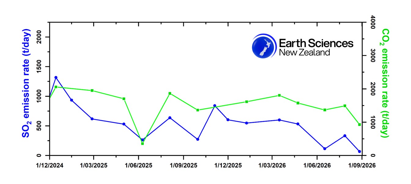
SO2 and CO2 emission rates measured during gas flight since December 2024
No crater lake has been present in the active crater since late June 2024. Low to moderate steam emissions continue from the active vent, and there has still been no evidence of ash being emitted at Whakaari/White Island for the past two months.
Without sensors on the island, our monitoring of Whakaari/White Island continues to rely on remote cameras, satellite imagery, and periodic gas and observation flights. As a result, whilst our observations currently suggest a generally low level of activity, we cannot distinguish between Volcanic Alert Level (VAL) 1 and 2. The Volcanic Alert Level therefore currently remains at 2 (moderate to heightened unrest) – and will remain at least at 2 until on-island monitoring is reinstated. The Aviation Colour Code remains at Yellow.
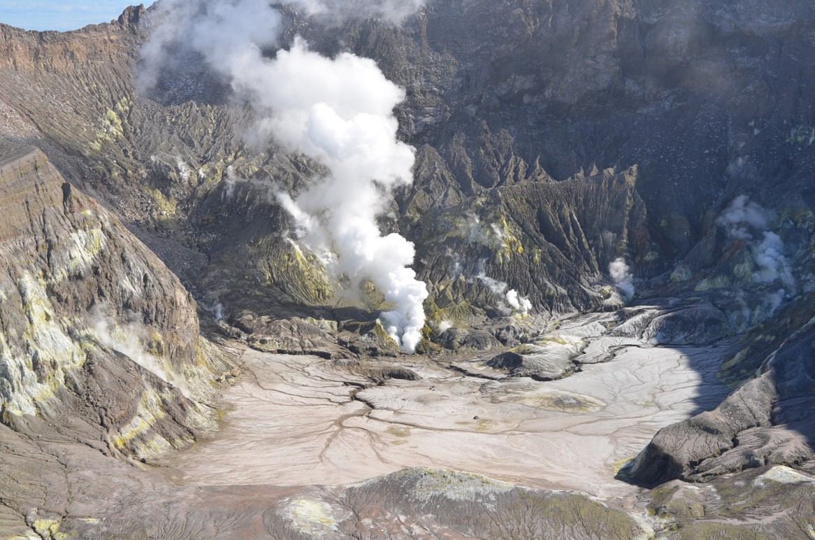
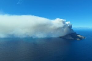
Image of the steam and gas plume at Whakaari/White Island captured at the observation flight on 20 August 2026
Eruptive volcanic activity can still occur with little to no warning. Future eruptions could affect the crater floor and immediate vicinity of the island, while ashfall affecting the mainland remains unlikely.
The Earth Sciences New Zealand Volcano Monitoring Group, and National Geohazards Monitoring Centre continue to closely monitor Whakaari/White Island for any changes in activity.
Source : Geonet / Agnes Mazot / Duty Volcanologist
Hawaii , Kilauea :
HAWAIIAN VOLCANO OBSERVATORY DAILY UPDATE , U.S. Geological Survey.
Wednesday, September 2, 2026, 9:30 AM HST (Wednesday, September 2, 2026, 19:30 UTC)
19°25’16 » N 155°17’13 » W,
Summit Elevation 4091 ft (1247 m)
Current Volcano Alert Level: ADVISORY
Current Aviation Color Code: YELLOW
Summary:
Kīlauea volcano is not erupting; the summit eruption in Halemaʻumaʻu is paused. Summit reinflation has increased over the past day. A forecast window of September 7-12 is likely for the next fountain episode.
Overview:
The summit eruption of Kīlauea in Halemaʻumaʻu is paused. A few very brief instances of flames were observed overnight from the north vent. Summit reinflation has been very irregular since lava fountaining episode 54 on August 25, and it has increased again over the past day. The current reinflation pattern is similar to what followed the last few episodes. A broad forecast window of September 7-12 is likely for the next episode if inflation follows the prior patterns.
No significant activity has been noted along Kīlauea’s East Rift Zone or Southwest Rift Zone.
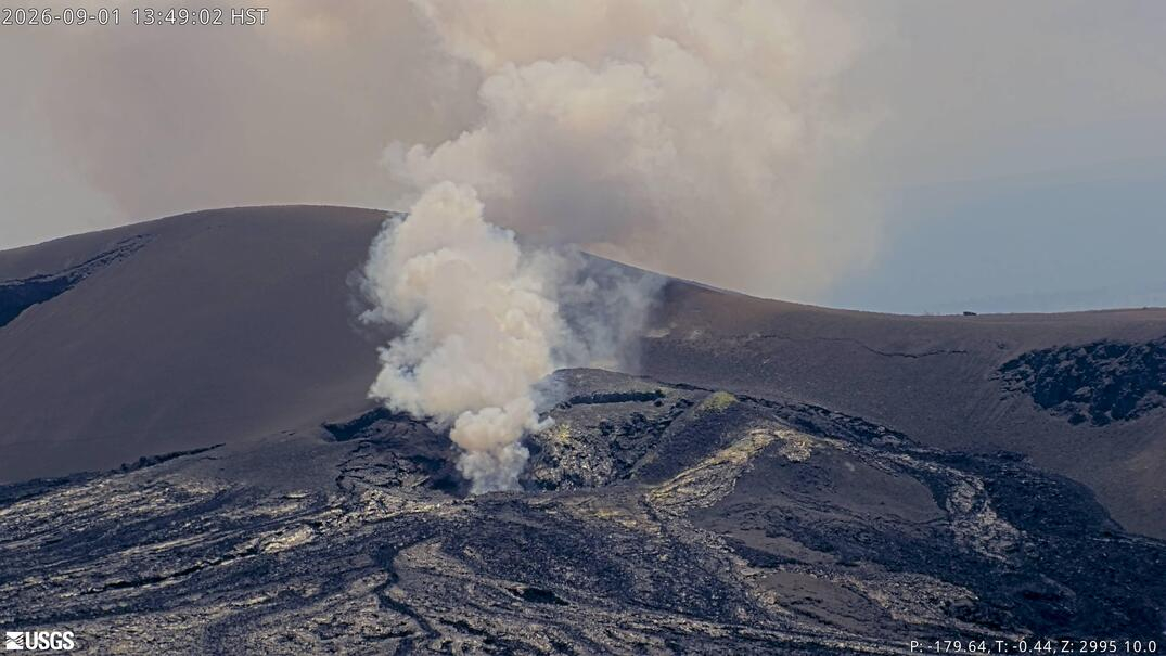
Summit Observations:
Overnight webcam views showed several very brief instances of weak to moderate flames from the Halemaʻumaʻu north vent. Two examples were observed around 10:40 p.m. and 5:40 a.m. HST, which coincided with tremor patterns indicative of gas pistoning. Release and combustion of volcanic gas (likely hydrogen) appears to be occurring deep within the vent, in association with larger tremor bursts observed in seismic data streams. Little or no glow appears to be derived from incandescent magma, suggesting it is relatively deep and possibly crusted over between gas release bursts.
Low-frequency seismic tremor bursts—which began after the conclusion of lava fountaining episode 54—continued over the past day but were sporadic overnight. As discussed above, the larger bursts are related to flames at the north vent, probably representing gas release deep within the vent. No shallow earthquakes have been recorded beneath the summit region over the past 24 hours.
Summit reinflation has been very unsteady since lava fountaining episode 54 on August 25, and it began increasing again around 3:00 p.m. HST yesterday. As of this update, the Uēkahuna (UWD) tiltmeter has measured a total of 5.4 microradians of inflation relative to the end of lava fountaining episode 54; this value is very low for being almost a week removed from the episode. Deflationary tilt on UWD totaled 12.7 microradians during episode 54.
During inter-episode pauses, the sulfur dioxide (SO2) emission rate from the summit typically varies between 1,000 and 5,000 tonnes per day. Strong trade winds are pushing the degassing plume to the southwest over the Kaʻū Desert this morning.
Rift Zone Observations:
Rates of seismicity and ground deformation remain low in the East Rift Zone and Southwest Rift Zone. SO2 emissions from the East Rift Zone remain below the detection limit.
Source et photo : HVO
United – States , Yellowstone :
YELLOWSTONE VOLCANO OBSERVATORY MONTHLY UPDATE , U.S. Geological Survey
Tuesday, September 1, 2026, 6:55 PM MDT (Wednesday, September 2, 2026, 00:55 UTC)
44°25’48 » N 110°40’12 » W,
Summit Elevation 9203 ft (2805 m)
Current Volcano Alert Level: NORMAL
Current Aviation Color Code: GREEN
Summary:
background seismicity and deformation
Yellowstone Caldera activity remains at background levels, with 61 located earthquakes in August (largest = M2.0). Deformation measurements indicate no significant uplift of the north caldera rim since January 2026 and only minor uplift of the caldera since the beginning of the year.
Recent Work and News
August field work included studies of hydrothermal explosion craters and glacial geology, as well as continued upgrades to the Yellowstone Seismic Network. In September, YVO hopes to bring a new seismic and infrasound station fully online in Upper Geyser Basin. The station is designed to record hydrothermal activity in the region, especially in the vicinity of Geyser Hill.
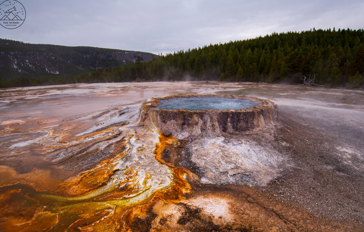
Black Diamond Pool, in Biscuit Basin, had a few small eruptions in early to mid August. Monitoring data suggest there was also one large eruption that probably threw water and mud tens of feet (many meters) into the air, but it occurred at about 10 PM on August 13, and no visual observations from nearby cameras were possible. Water temperature data indicate no clear eruptions and only two overflow events on August 22 at Echinus Geyser, in Norris Geyser Basin, and nearby Steamboat Geyser had only minor eruptive activity during the month. Giant Geyser, in Upper Geyser Basin, erupted on August 17 and 30—its second and third eruptions of the year.
Seismicity
During August 2026, the University of Utah Seismograph Stations, responsible for the operation and analysis of the Yellowstone Seismic Network, located 61 earthquakes in the Yellowstone National Park region. The largest event of the month was a micro earthquake of magnitude 2.0 located about 22 miles east-northeast of Canyon Village in Yellowstone National Park on August 5 at 4:05 p.m. MDT.
There were no swarms identified during August.
Earthquake activity in Yellowstone is at background levels.
Ground Deformation
Data from continuous GPS stations indicate that the uplift that started in July 2025 on the north caldera rim ceased by mid-January 2026 and has not resumed. Subtle uplift of the caldera itself amounted to about 1 cm or less (a fraction of an inch) over the course of the past few months, possibly due to seasonal variations associated with groundwater conditions.
Source : YVO.
Photo : Pod Tatrami
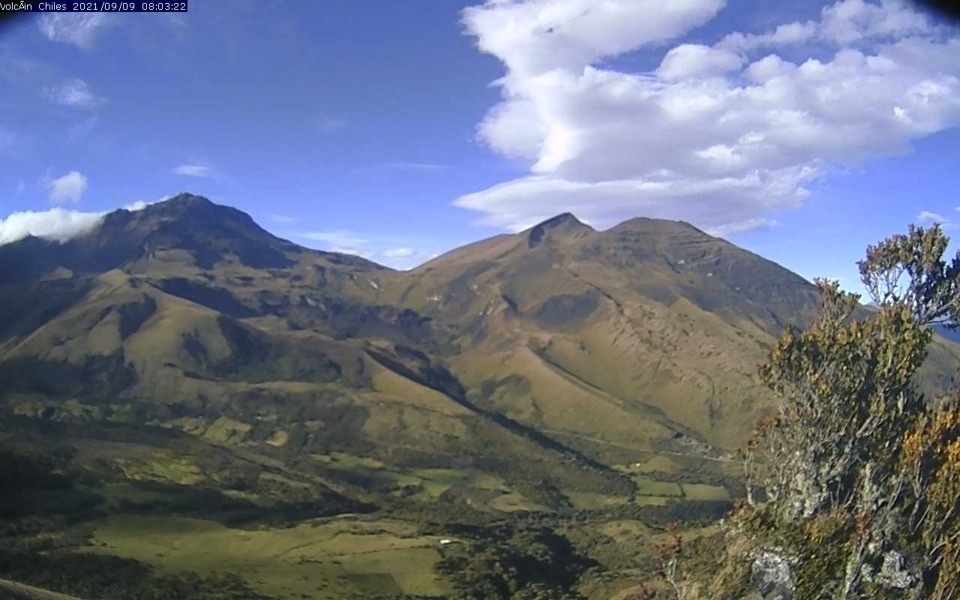
Colombia , Chiles / Cerro Negro :
San Juan de Pasto, September 1, 2026, 5:20 PM.
Based on monitoring of the Chiles-Cerro Negro volcanic complex (CVCCN), the Colombian Geological Service (SGC)—an entity affiliated with the Ministry of Mines and Energy—reports the following information:
For the period from August 25 to August 31, 2026, the main changes in monitored parameters compared to the previous week were as follows:
● Amidst the volcanic complex’s fluctuating behavior, seismic activity showed a slight increase in both event frequency and energy release. Notably, there was a balanced distribution between earthquakes associated with rock fracturing and those linked to fluid dynamics.
● During this period, seismic activity was distributed across areas both near and far from the volcanic edifices—primarily south of the Chiles volcano—at distances of up to 12 km from Chiles, at depths ranging from 2 to 15 km below its summit (4,700 m elevation), and with magnitudes below 1.5.
● Analysis of data from satellite sensors and ground stations has continued to reveal variations associated with deformation processes in the volcanic zone.
Based on the assessment and correlation of monitored parameters, the SGC recommends closely monitoring the situation’s evolution via weekly bulletins and other information released through our official channels, as well as adhering to the instructions of local and departmental authorities and the National Unit for Disaster Risk Management (UNGRD).
Volcanic activity remains at the yellow alert level: an active volcano showing changes in the baseline behavior of monitored parameters and other manifestations.
Source et photo : SGC.