August 1 , 2026.
Italy / Sicily , Etna :
Statement on Mount Etna activity, July 31, 2026, 10:23 (08:23 UTC).
The National Institute of Geophysics and Volcanology (INGV), Etna Observatory, reports that the effusive activity that began yesterday (July 30) at 18:49 UTC in the upper part of the Valle del Leone—at an elevation of approximately 2,700 m above sea level—continued overnight.
It has currently reached an elevation estimated between 1,700 and 1,750 m above sea level, upslope of Rocca Capra. The lava flow is currently being fed; however, analysis of images from the camera network indicates that the flow’s most advanced fronts appear to be receiving little supply. Field surveys are underway to allow for a
more precise characterization of the phenomena.
Yesterday (July 30), the intense Strombolian activity at the Voragine crater—which had gradually subsided and temporarily ceased around 11:00 UTC—resumed around 16:50 UTC. It progressively intensified, reaching a very vigorous level around 19:55 UTC.
This vigorous activity continued until approximately 23:40 UTC, before ceasing abruptly around midnight (00:00) today.
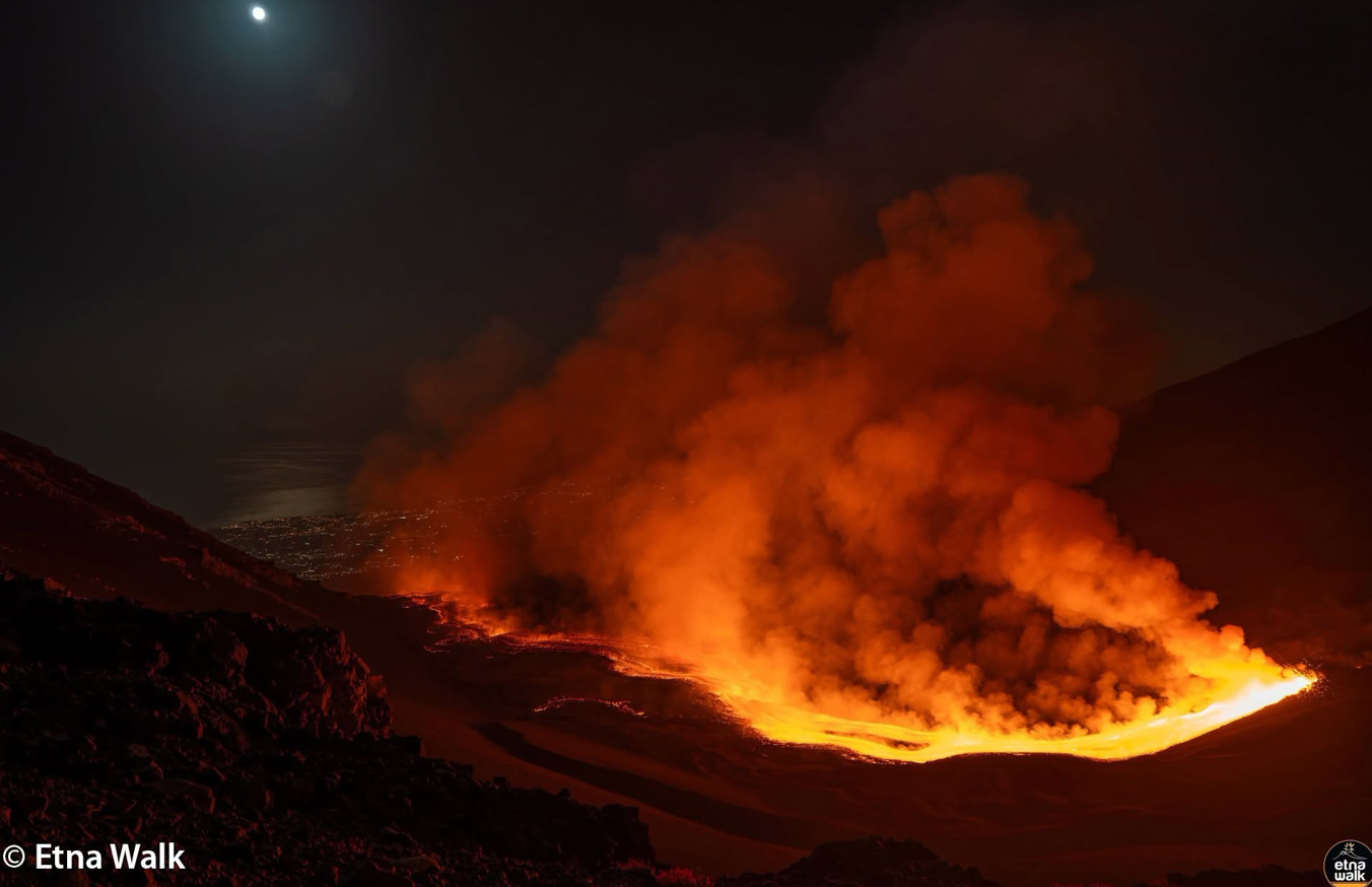
Strombolian activity generated an ash plume that reached an altitude of approximately 7,000 m above sea level, drifting towards the southwest (SW). Since the last update (issued at 19:30 UTC), the average amplitude of volcanic tremor remained high with an upward trend; however, starting at 23:40 UTC, it experienced a sudden drop, falling to low levels around 01:00 UTC—levels at which it currently remains. The tremor source was located—up until 01:00 UTC—in the Voragine and Bocca Nuova crater area (at approximately 3,000 m above sea level), and subsequently in the Southeast Crater area (at altitudes between 2,500 and 2,900 m above sea level).
Infrasonic activity—following a renewed increase in the frequency and energy of events located in the Voragine crater area—returned to a low level starting at 01:00 UTC; event sources are currently located in the Northeast Crater and Bocca Nuova areas.
Since 00:00 UTC, no significant changes have been recorded in the time series from ground deformation monitoring stations.
Further information will be provided as soon as possible.
Source : INGV.
Photo : Etna Walk / Giuseppe Distefano / Marco Restivo.
Italy , Campi Flegrei :
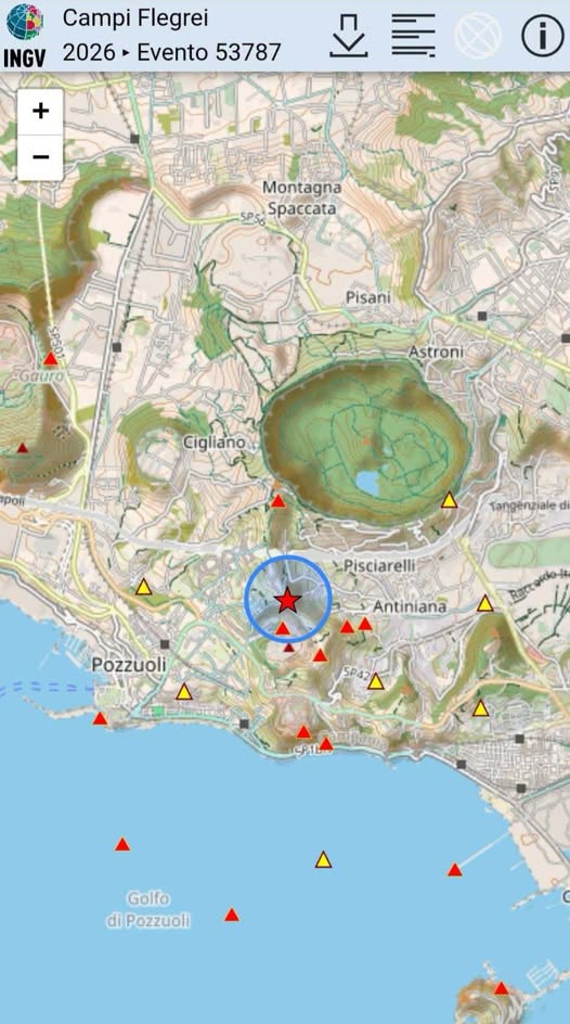
As of 5:46 PM on July 31, 2026, seismic activity is underway in the Campi Flegrei region.
Preliminary data associated with this notification indicate 10 earthquakes with a magnitude of Md ≥ 0.0, with a maximum magnitude of Md = 4.7 ± 0.3.
A magnitude 4.7 earthquake recorded this evening in the Campi Flegrei region—clearly felt by the population and resulting in damage and some injuries—is an event requiring the utmost attention. The INGV immediately activated all established protocols, intensifying monitoring activities and convening the Institute’s Crisis Unit.
Kamchatka , Sheveluch :
KVERT VOLCANIC ACTIVITY NOTICE (VAN)
Issued: July 31 , 2026
Volcano: Sheveluch (CAVW #300270)
Current aviation colour code: ORANGE
Previous aviation colour code: red
Source: KVERT
Notice Number: 2026-84
Volcano Location: N 56 deg 38 min E 161 deg 19 min
Area: Kamchatka, Russia
Summit Elevation: 3283 m (10768.24 ft), the dome elevation ~2500 m (8200 ft)
Volcanic Activity Summary:
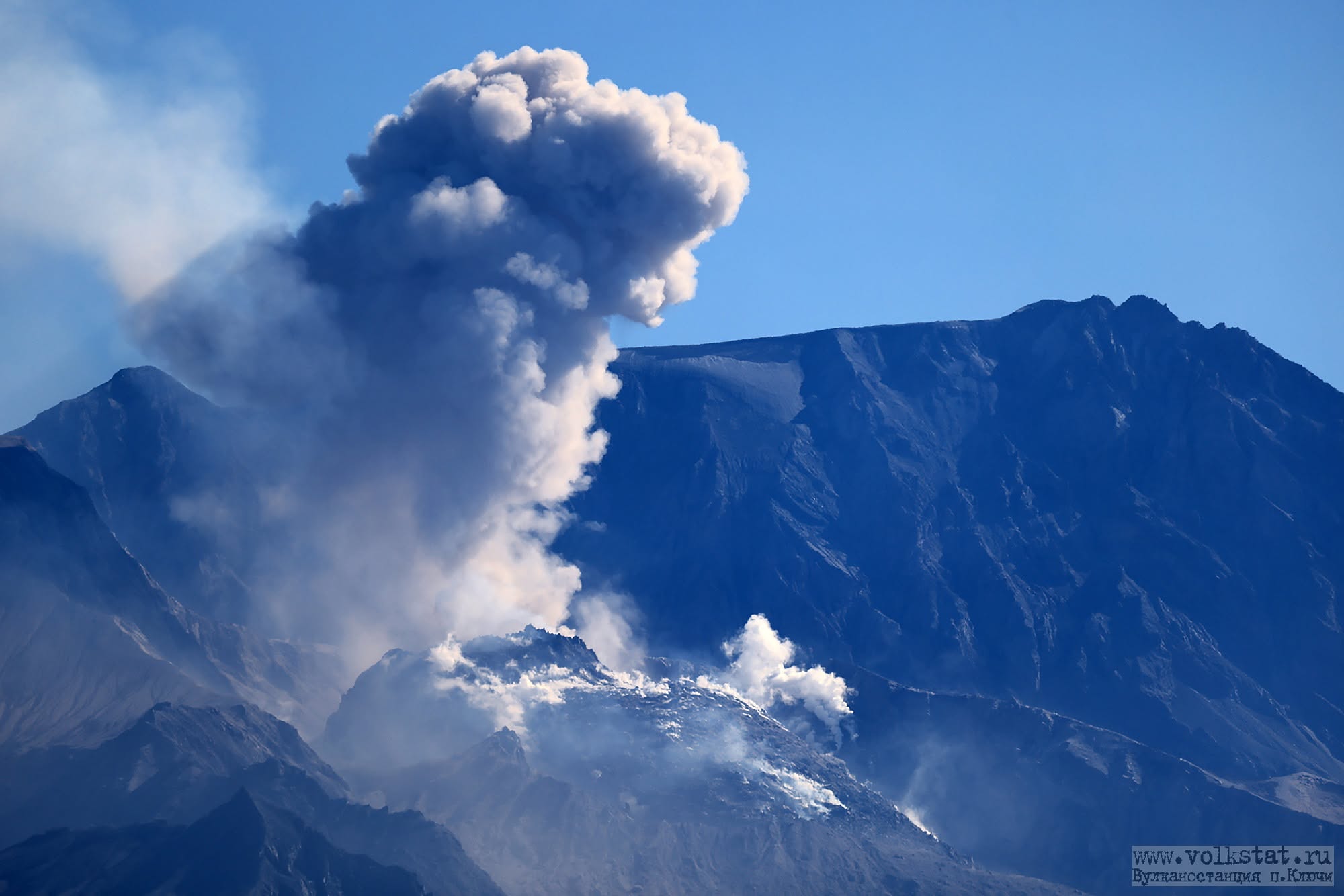
The explosive-extrusive eruption of the volcano continues, accompanied by powerful gas-steam activity; a new block of lava continues to grow in the northern part of the lava dome. No new ash explosions have been observing on the volcano at now, but at 08:10 UTC on 31 July an ash cloud 390×60 km in size was located 454 km to the east of the volcano (from ash explosions up to 10 km a.s.l. at 05:02 UTC on 31 July).
The explosive-extrusive eruption of the volcano continues. Ash explosions up to 12 km (39,400 ft) a.s.l. could occur at any time. Ongoing activity could affect international and low-flying aircraft.
Volcanic cloud height: NO ASH CLOUD PRODUCED
Other volcanic cloud information: NO ASH CLOUD PRODUCED
Source : Kvert.
Photo : volkstat ru.
Colombia , Nevado del Ruiz :
Manizales, July 31, 2026, 11:00 AM. Volcanic activity in the northern segment of Colombia
Based on volcanic activity monitoring during June 2026, the Colombian Geological Service (SGC)—an agency attached to the Ministry of Mines and Energy—presents this activity report regarding the volcanic structures making up the northern segment of Colombia, highlighting significant variations compared to the previous month:
Nevado del Ruiz Volcano
The Nevado del Ruiz volcano (VNR) continued to exhibit unstable behavior. In June, notable variations were observed in seismic activity and sulfur dioxide (SO2) degassing. However, despite these variations, the volcano’s overall activity remained at a low level, with no confirmed ash emissions, thus continuing the general downward trend observed in recent months. The main variations noted in the monitored parameters are as follows:
– Seismicity associated with rock-fracturing processes within the volcanic edifice (volcano-tectonic, VT) showed a marked decrease in the number of recorded events but an increase in released seismic energy. The earthquakes were primarily located near the Arenas crater as well as in the north-northeast and northeast sectors of the volcano, at distances of up to 5 km from the crater.
Although the total number of earthquakes was lower than in May, higher-magnitude events were recorded in June; notably, a magnitude 3.0 earthquake occurred on June 13 at 2:15 PM, located 2 km north of the Arenas crater at a depth of 3 km. This is the highest magnitude recorded this year to date.
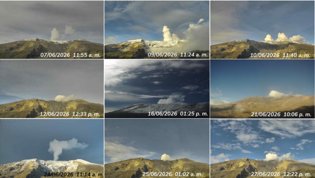
Photographs of the water vapor and volcanic gas plume captured by the surveillance camera network during June 2026. The image from June 24 shows the plume reaching the greatest vertical height (1,100 m above the crater rim) observed during the month. The date and time are shown in local format (UTC minus 5 hours).
Emissions of water vapor and volcanic gases—primarily sulfur dioxide (SO₂)—from the Arenas crater showed a variable trend. SO₂ flux rates associated with degassing processes decreased compared to the previous month; however, they remained higher than the levels recorded during the first few months of the year. Significant degassing rates persisted during the first half of the month—notably the value estimated on June 4—while a gradual decline in SO₂ flux was observed during the second half. This trend was consistent with complementary satellite monitoring data, which also indicated a decrease in the amount of SO₂ detected in the atmosphere towards the end of the period.
Source et photo : SGC.
Costa Rica , Poas :
OVSICORI-UNA Weekly Volcanic Monitoring Bulletin, July 31, 2026
Latitude: 10.20° N;
Longitude: 84.23° W;
Elevation: 2,687 m above sea level.
An eruption (infrasonic magnitude of 3.7) was recorded on the night of July 24. The eruption column reached a height of approximately 200 m and ejected incandescent rocks into the crater. The following morning, minor eruptions (<50 m) were observed with no associated seismic signal and very low acoustic magnitudes. Tremor amplitude had gradually decreased over the previous week but increased following the July 24 eruption. The number of long-period events is increasing. Two volcano-tectonic earthquakes were recorded—one in the immediate vicinity of the crater and the other further away on the northwest flank, with magnitudes of 1.4 and 2.3, respectively. Both occurred after the eruption.
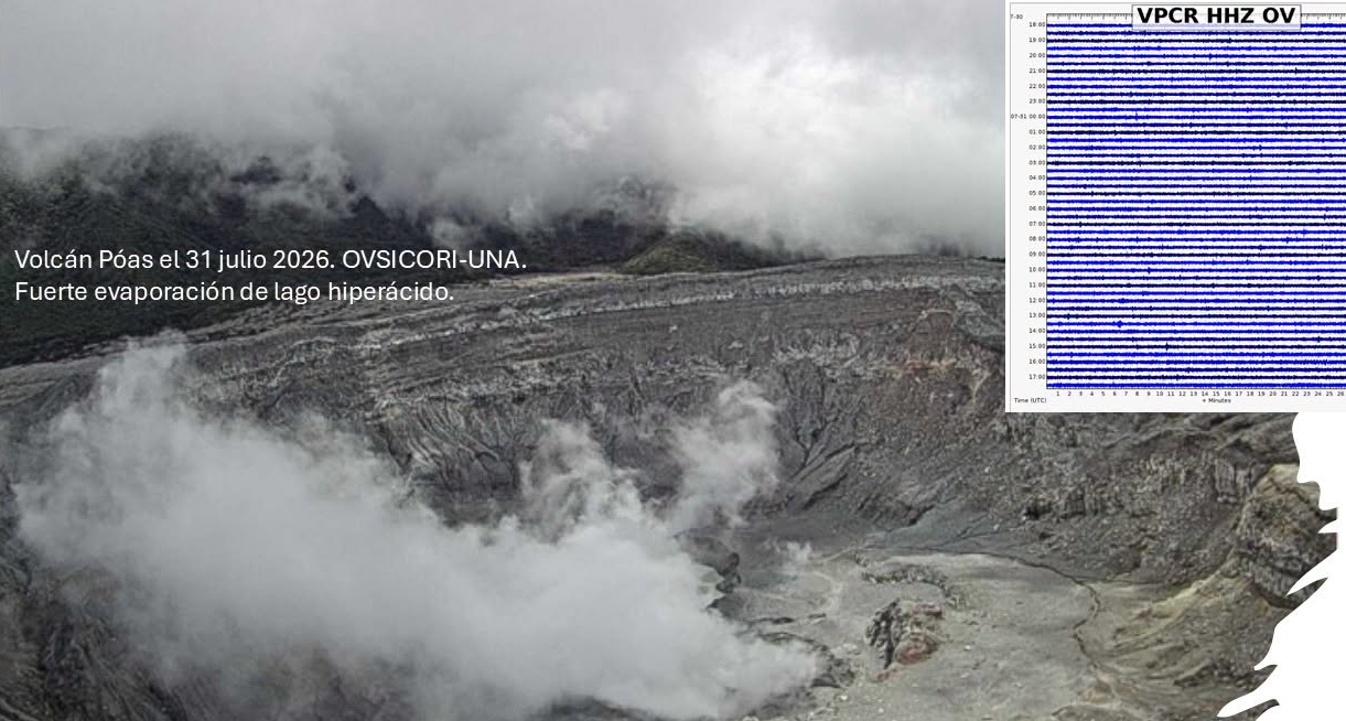
The geodetic network shows no significant deformation. Multi-gas stations at vents A and C detected an increase in the SO2/CO2 ratio (1.55 ± 0.56 and 1.10 ± 0.46, respectively) and in the SO2 concentration (15.59 ± 0.56 ppm and 9.41 ± 6.17 ppm, respectively) compared to the previous week. The H2S/SO2 ratio shows values of 0.06 ± 0.18 and 0.01 ± 0.01 at vents A and C, respectively. NOVAC stations recorded a daily SO2 flux of 191 ± 89 tonnes, an increase over the previous week (149 ± 49 t/d). The hyperacidic lake at Poás exhibits a milky-gray color. Since the beginning of 2025, the lake’s water chemistry has been dominated by chloride ions derived from hydrogen chloride gas escaping from a near-surface magma body that is progressively degassing and cooling.
Source et photo : Ovsicori