July 4 , 2026.
Italy / Sicily , Etna :
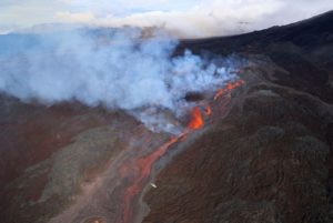
Statement on Mount Etna activity, July 2, 2026, 12:54 (10:54 UTC).
The National Institute of Geophysics and Volcanology (INGV) – Etna Observatory reports that, based on field observations by INGV-OE personnel and analysis of video surveillance footage, effusive activity is continuing at the vent located at an elevation of 3,030 m. This activity is feeding a lava field composed of multiple superimposed flows. Currently, the most advanced flow front is located at an estimated elevation of approximately 2,620 m. Additionally, Strombolian activity of varying intensity is ongoing at the depression situated on the upper flank of the Voragine crater; this activity is currently in progress, as confirmed by INGV personnel in the field.
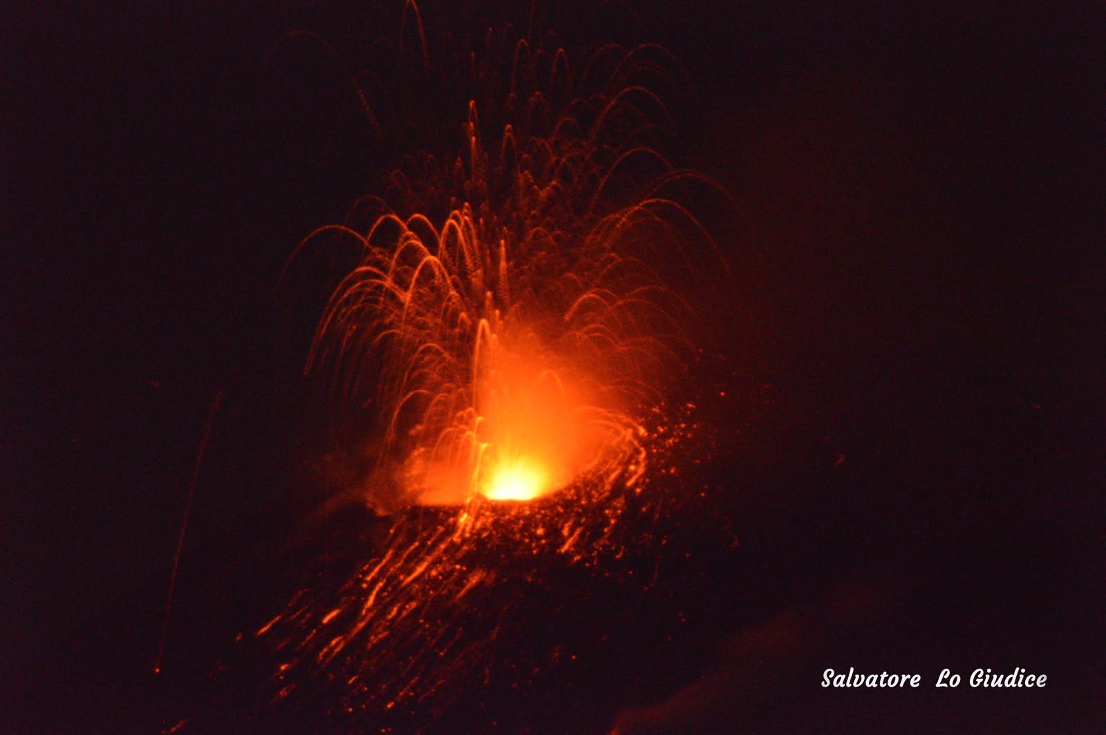
The average amplitude of volcanic tremor shows a slow but steady upward trend; since yesterday, amplitudes have consistently remained in the high range. The centroid of the tremor sources remains located in the Voragine crater area, at an elevation of approximately 3,000 m. Infrasonic activity is currently at a moderate level, in terms of both the number of events and the energy released. The sources remain located at the Northeast Crater, although an additional source has been observed at the Voragine crater since yesterday afternoon, associated with Strombolian activity. No significant changes have been detected in the time series from ground deformation monitoring stations.
Further updates will be provided as soon as possible.
Source : INGV.
Photo : Salvatore Lo Giudice.
Japan , Tokachidake :
The Japan Meteorological Agency (JMA) reported intensifying unrest at Tokachidake. Deformation data recorded persistent inflation at shallow depths starting in March. Seismicity near Crater 62-2 began increasing in April with spikes in the number of events occasionally occurring in May and June. Field surveys conducted on 28 April and 10 June revealed sulfur dioxide emission rates of 1,200 and 1,400 tons per day, respectively; these levels were higher than those in March. Beginning in April monitoring webcams recorded faint incandescence from Crater 62-2, possibly from high-temperature gas emissions and the combustion of sulfur. During 16-17 June field visits scientists observed high-temperature volcanic gas rising from the 62-2 Crater and the Furiko-sawa fumarole area; the fumarolic area had expanded and was releasing a larger volume of gases. They also observed repeated ejections of hot, muddy water from a part of the crater floor. At 1100 on 18 June the Alert Level was raised to 2 (on a scale of 1-5) and the public was warned that eruptive products may impact areas within 1.5 km of the crater.
Tokachidake volcano consists of a group of dominantly andesitic stratovolcanoes and lava domes arranged on a NE-SW line above a plateau of welded Pleistocene tuffs in central Hokkaido. Numerous explosion craters and cinder cones are located on the upper flanks of the small stratovolcanoes, with the youngest Holocene centers located at the NW end of the chain. Frequent historical eruptions, consisting mostly of mild-to-moderate phreatic explosions, have been recorded since the mid-19th century. Two larger eruptions occurred in 1926 and 1962. Partial cone collapse of the western flank during the 1926 eruption produced a disastrous debris avalanche and mudflow.
Sources: Japan Meteorological Agency (JMA) , GVP.
Photo : 我路・幌内画像倉庫 / Wiki.
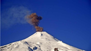
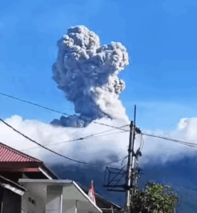
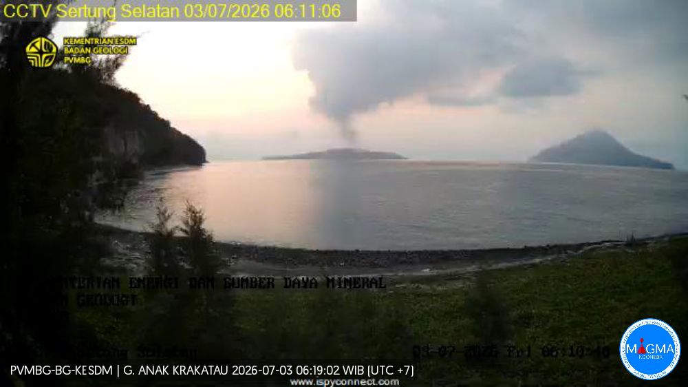
Indonesia , Anak Krakatau :
The Pusat Vulkanologi dan Mitigasi Bencana Geologi (PVMBG) reported increasing unrest at Krakatau. Sulfur dioxide emissions began to be detected in satellite data on 1 June and thermal anomalies were identified starting on 10 June. Emissions at the active crater intensified. The seismic network recorded an increase in shallow earthquake activity, specifically signals indicating gas-and-steam emissions, hybrid/multiphase events, and low-frequency events; the number of these signals notably increased during 18-19 June, averaging more than 50 events per day. Crater incandescence was visible in a webcam image at 2313 on 19 June. Though there was an increase in shallow activity, there were no deep volcanic earthquakes nor ground deformation detected. The Alert Level remained at 2 (on a scale of 1-4), and the public was warned to stay 2 km away from the active crater.
Seismic observations
4 hybrid/polyphase earthquakes with amplitudes of 3–12 mm and durations ranging from 3 to 9 seconds.
1 shallow volcanic earthquake with an amplitude of 8 mm and a duration of 8 seconds.
1 episode of continuous tremor with amplitudes of 1–5 mm (dominant amplitude: 2 mm).
Recommendations
The public, visitors, tourists, and hikers must not approach Mount Anak Krakatau or engage in activities within a 3 km radius of the active crater.
Sources et photo : Pusat Vulkanologi et Mitigasi Bencana Geologi (PVMBG, également connu sous le nom de CVGHM) , GVP.
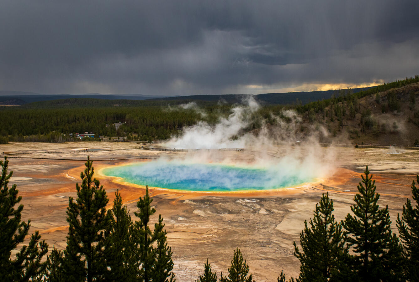
United States , Yellowstone :
YELLOWSTONE VOLCANO OBSERVATORY MONTHLY UPDATE , U.S. Geological Survey
Wednesday, July 1, 2026, 11:49 AM MDT (Wednesday, July 1, 2026, 17:49 UTC)
44°25’48 » N 110°40’12 » W,
Summit Elevation 9203 ft (2805 m)
Current Volcano Alert Level: NORMAL
Current Aviation Color Code: GREEN
Summary:
Yellowstone Caldera activity remains at background levels, with 118 located earthquakes in June (largest = M2.4). Deformation measurements indicate no significant uplift or subsidence of the caldera or north caldera rim since January 2026. A small hydrothermal explosion occurred in Biscuit Basin on June 13.
Recent Work and News
A small hydrothermal explosion occurred in Biscuit Basin at about 5:09 a.m. MDT on June 13. The event took place 30–60 meters (100–200 feet) north of Black Diamond Pool and was well recorded by seismic and acoustic monitoring in the basin, and it threw rocks a few meters (tens of feet) into the air and discharged large amounts of sediment-rich hot water into the Firehole River, causing a temporary discoloration for many kilometers (miles) downstream. The explosion opened several vent areas, some of which were full of near-boiling water when observed the following day, including a crack that was about 18 meters (60 feet) long. A day or two after the explosion, a pool of boiling water formed by collapse. That pool was observed to erupt like a geyser on June 18 and again on June 23. Black Diamond Pool and other thermal features in Biscuit Basin were not impacted by the new hydrothermal activity, and Black Diamond Pool had at least two very small eruptions (about 1 meter, or 3 feet, in height) in late June. Biscuit Basin has been closed to visitors since the July 23, 2024, hydrothermal explosion from Black Diamond Pool that destroyed a stretch of boardwalk in the basin.
Echinus Geyser, in Norris Geyser Basin, remained active, with one eruption in June. In July, Yellowstone Volcano Observatory scientists plan to begin installation of a new monitoring station that will include seismic and infrasound sensors in Upper Geyser Basin.
Seismicity
During June 2026, the University of Utah Seismograph Stations, responsible for the operation and analysis of the Yellowstone Seismic Network, located 118 earthquakes in the Yellowstone National Park region. The largest event of the month was a microearthquake of magnitude 2.4 located about 12 miles south-southeast of Lake in Yellowstone National Park on June 7 at 5:52 a.m. MDT.
June seismicity in Yellowstone was marked by three swarms:
1. A swarm of 25 earthquakes occurred about 12 miles south-southeast of Lake in Yellowstone National Park during June 6–9. The magnitudes ranged from M0.3 to M2.4. The largest earthquake in the sequence was also the largest in June (described above).
2. A swarm of 20 earthquakes took place approximately 12 miles north-northeast of West Yellowstone, Montana, during June 22–25. The range of magnitudes was M0.2–2.1.
3. A swarm of 16 small earthquakes occurred about 10 miles north-northeast of Old Faithful in Yellowstone National Park during June 14–15 and had magnitudes spanning the range M0.5–1.6.
Earthquake activity in Yellowstone is at background levels.
Ground Deformation
Data from continuous GPS stations indicate little net deformation in the region since January 2026. The uplift that started in July 2025 on the north caldera rim ceased by mid-January 2026, and there has been no uplift or subsidence of Yellowstone Caldera since December 2025.
Source : YVO.
Photo : USGS , 10/2023 /Grand Prismatic Spring.
Alaska , Kupreanof :
The Alaska Volcano Observatory (AVO) reported that unrest at Kupreanof continued through 24 June characterized by gas emissions, seismic activity, and deformation. Shallow seismicity remained at elevated levels with more than 30 earthquakes of magnitudes of 1 or greater detected since 12 May, when the Alert Level was first raised. The largest events during the current phase of unrest, which began in February, occurred on 15 and 16 June and had magnitudes of 3.2 and 3.6, respectively. Sulfur dioxide emissions were detected in satellite data on 13 days during 12 May-22 June with calculated emission rates of 100-800 tons per day, similar to the rate of emissions detected since April. These elevated emission rates were consistent with degassing of new, relatively shallow, magma beneath the volcano.
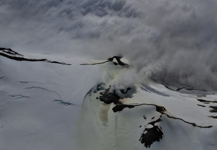
Satellite interferometric radar (InSAR) ground deformation data was collected in mid-June following sufficient snow melt. A comparison with data from 30 September 2025, before snow covered the area, indicated that ground uplift around the volcano occurred sometime in the past eight months. The source depth of the inflation signal was estimated at 6 km below sea level, consistent with a magmatic intrusion and in agreement with the seismic and gas data. The Volcano Alert Level remained at Advisory (the second level on a four-level scale) and the Aviation Color Code remained at Yellow (the second color on a four-color scale).
Sources: US Geological Survey Alaska Volcano Observatory (AVO) , GVP.
Photo : Read cirrus / avo/usgs