June 28 , 2026.
Hawaii , Kilauea :
HAWAIIAN VOLCANO OBSERVATORY STATUS REPORT , U.S. Geological Survey
Saturday, June 27, 2026, 6:59 PM HST (Sunday, June 28, 2026, 04:59 UTC)
19°25’16 » N 155°17’13 » W,
Summit Elevation 4091 ft (1247 m)
Current Volcano Alert Level: ADVISORY
Current Aviation Color Code: YELLOW
Summary:
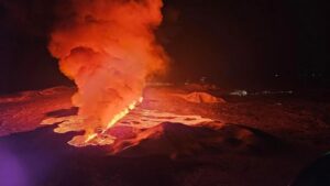
Episode 50 of the ongoing Halemaʻumaʻu eruption at the summit of Kīlauea ended abruptly at 5:10 p.m. HST on June 27. The eruption is currently paused.
Activity Summary:
Episode 50 of the ongoing Halemaʻumaʻu eruption at the summit of Kīlauea ended abruptly at 5:10 p.m. HST on June 27, 2026, after 7 hours of continuous lava fountaining from the north vent. The eruption is currently paused.
Tephra fall was restricted mostly to the closed area of Hawaiʻi Volcanoes National Park to the southwest of the active Halemaʻumaʻu vents. A light fall of Peleʻs hair was reported from the town of Pāhala in Kaʻū.
Episode 50 Chronology:
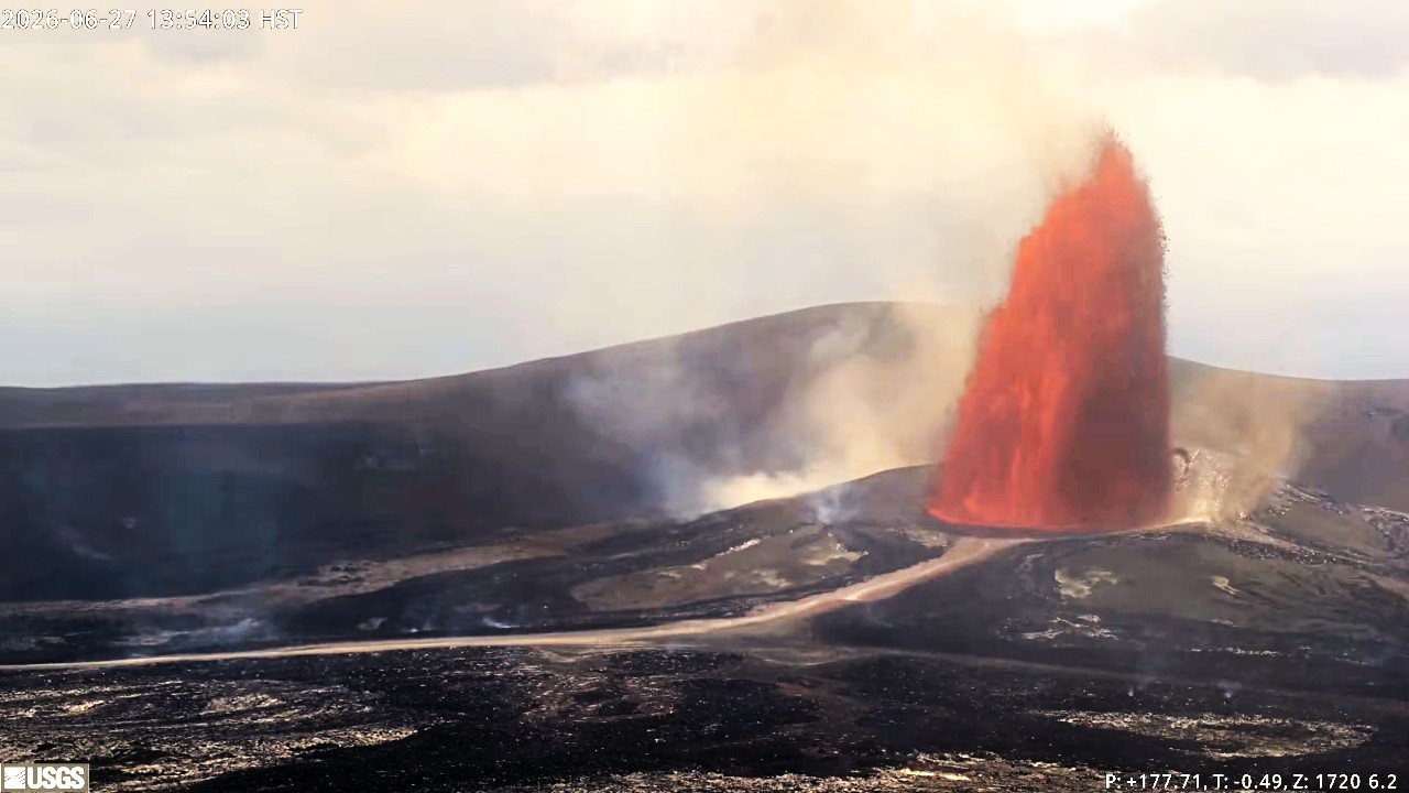
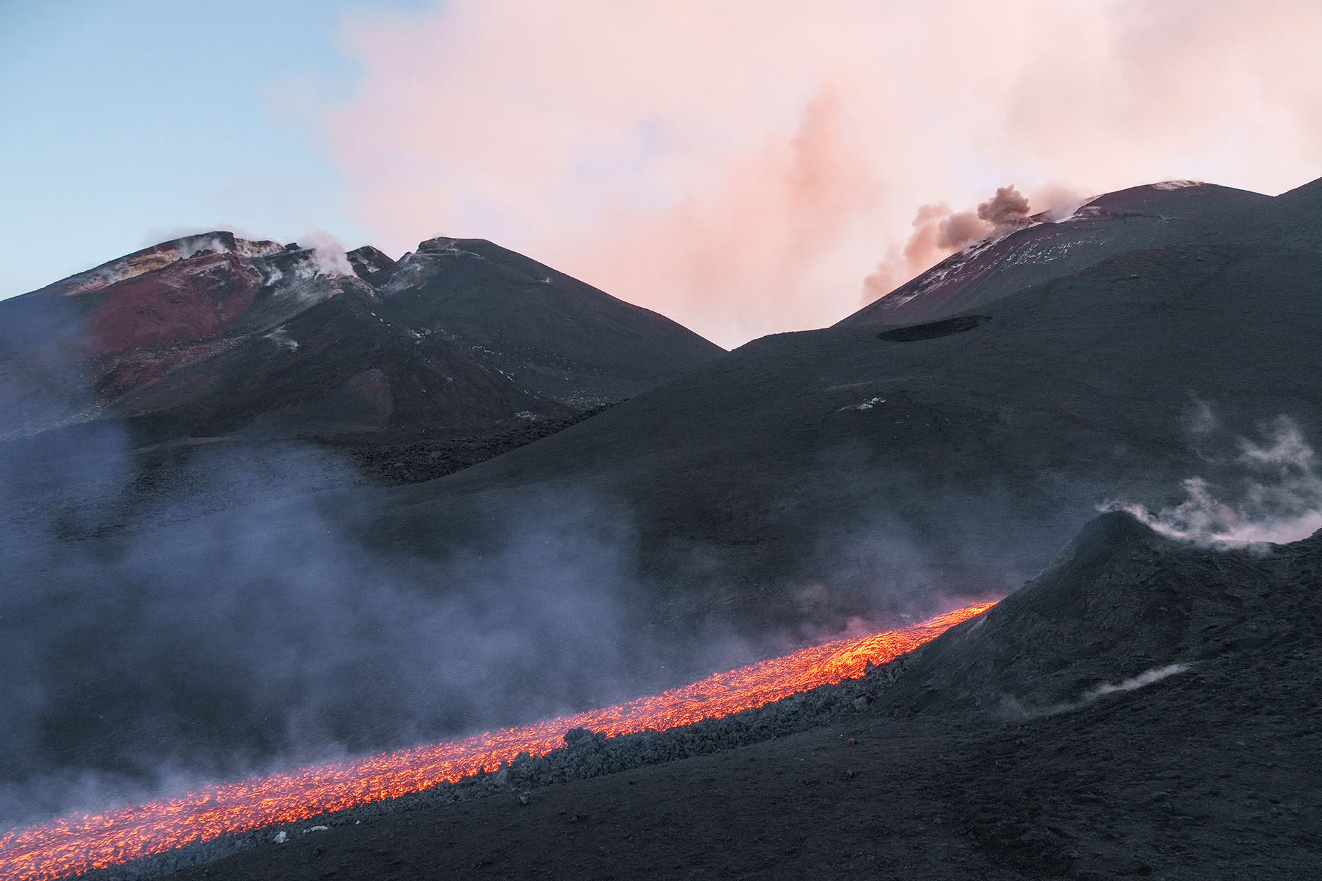
Lava fountaining episode 50 in Halemaʻumaʻu at the summit of Kīlauea began at 10:10 a.m. HST on June 27 and stopped abruptly at 5:10 p.m. HST, after 7.0 hours of continuous fountaining from the north vent. The last 2-3 minutes were marked by gas jetting from the north vent. The south vent never fountained during this episode. The instantaneous effusion rate peaked at about 430 cubic yards (330 cubic meters) per second between 10:30 and 11:00 a.m. HST, with an average effusion rate of 280 cubic yards (210 cubic meters) per second for the entire fountaining episode. An estimated 6.4 million cubic yards (4.9 million cubic meters) of lava erupted and covered about 50% of the Halemaʻumaʻu crater floor. The Uēkahuna tiltmeter (UWD) recorded about 15.3 microradians of deflationary tilt during episode 50. Seismicity followed the normal change in tremor patterns seen after most fountain episodes. There were no locatable earthquakes associated with the end of the eruption.
The initial signs of the approach of episode 50 began with brief periods of spattering associated with gas jetting and tremor spikes from the south vent that were first observed at 7:22 p.m. on the evening of June 24. These intensified over the next day and were joined by small spattering events from the north vent. Around 3:00 a.m. HST on June 26, activity from both the south and north vents increased, leading to the first precursory overflows. Episode 50 lava fountaining began a little over 25 hours after the onset of very short (<50 feet or 15 meters) precursory lava overflows at 8:50 a.m. HST from the north vent on the morning of June 26. The initial overflow lasted about 13 minutes and was followed by another north vent overflow from 9:25 to 9:40 a.m. HST. This was followed by an approximately 21-hour long break in eruptive activity only punctuated by brief episodes of spatter associated with gas jetting and tremor spikes from the south vent. Eruptions of precursory lava flows resumed from the north vent at 6:56 a.m. to 7:15 a.m. HST on the morning of June 27.
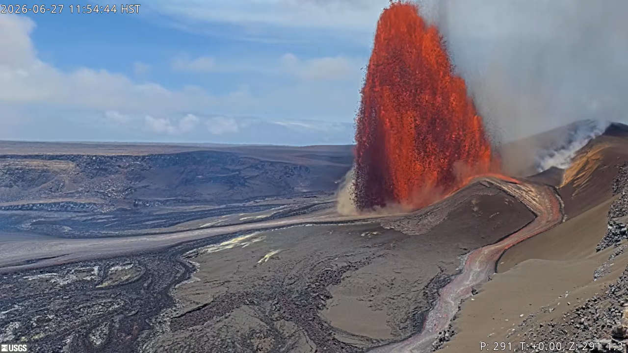
This was followed by another large precursory overflow that extended well onto the crater floor that began at 8:38 a.m. HST. The second precursory flow lasted for over an hour until the vent began to drain back at 9:41 a.m. HST. The drainback was associated with multiple large tremor spikes and led directly into the next precursory overflow at 9:46 a.m. HST. Dome fountains gradually increased from about 15 feet (5 meters) high to over 50-100 feet (15-30 meters) high by 10:10 a.m. HST as increasing tremor and rapidly dropping tilt marked the onset of episode 50 fountaining.
The north vent lava fountain reached a peak height of around 1,000 feet (300 meters) just after 11:30 a.m. HST and produced significant heat and ash, feeding a plume cloud that reached a maximum height of about 18,000 feet (5,500 meters) above sea level based on radar data and verified by webcam images. Winds were out of the northeast for most of the eruption causing the plume to move to the southwest during the most energetic part of the eruption. The National Weather Service issued an updated Special Weather Statement (SWS) at 11:28 a.m. HST discussing the possibility of ash and Peleʻs hair falling in the Kaʻū district near the towns of Pāhala and Naʻalehu. The plume track largely remained within Hawaiʻi Volcanoes National Park with most tephra falling in the closed area. The more distal part of the plume track roughly followed the Southwest Rift Zone and USGS field crews found a light fall of Peleʻs hair in the town of Pāhala around 1:30 p.m. HST. By this time the north vent fountain had dropped to 700 feet (210 meters) in height and the plume dropped slightly to 17,000 feet (5,000 meters) above sea level. The fountain and plume heights continued to gradually decrease in height to about 330 feet (100 meters) and 10,000 feet (3,000 meters) above sea level by 4:50 p.m. HST. Then the episode ended at 5:10 p.m. HST. No ash or tephra was reported from any other populated areas except for Pāhala during the eruption.
Source et photos : HVO
Italy / Sicily , Etna :
Statement on Mount Etna activity, June 27, 2026, 20:03 (18:03 UTC).
The National Institute of Geophysics and Volcanology (INGV) – Etna Observatory – reports that field inspections conducted by INGV personnel, notably using drones, indicate the continuation of the effusive activity that began on January 26 around 12:00 local time (as reported at 13:16 local time). This activity is fed by an eruptive vent located at an elevation of approximately 3,030 m above sea level, which is currently supplying a lava flow; in its distal section, the flow splits into two main branches, with the flow front reaching an estimated elevation of approximately 2,800 m above sea level.
During the inspection, no explosive activity was observed at the Voragine crater, only intense degassing.
Seismically, the amplitude of volcanic tremor has remained stable at moderate levels over the past twenty-four hours.
The tremor source has also remained centered on the Voragine crater, at an elevation of approximately 2,900 m above sea level. Infrasonic activity has held steady at a moderate level—in terms of both event frequency and energy—and remains localized at the Northeast Crater. No significant changes have been detected in signals from ground deformation monitoring stations.
Source : INGV.
Photo : Emilio Messina photography.
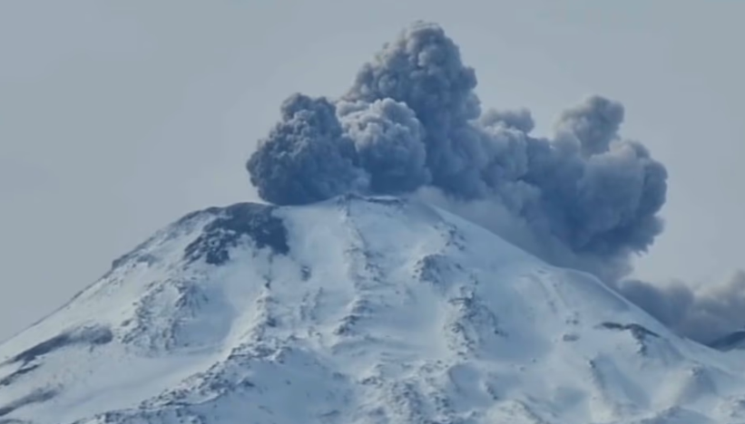
Chile , Nevados de Chillan :
A new eruptive phase at the Nevados de Chillán volcanic complex has kept Chilean and Argentine authorities on alert. The event occurred this Friday, June 26, around 11:00 a.m. (local time) at the Nicanor crater in Chile’s Ñuble region; it produced a plume of ash and pyroclastic material reaching a height of between 240 and 380 meters, according to various official sources.
The event, which lasted only a few minutes, was filmed by tourists in the Valle de Las Trancas area and quickly went viral on social media and in the news media. Chile’s National Geology and Mining Service (Sernageomin) confirmed the dispersal of pyroclastic material toward the southeast.
Sernageomin has maintained a yellow technical alert level since June 15, when a sustained increase in seismic activity—associated with fluid movements beneath the volcanic edifice—was detected.
Concurrently, the National Service for Disaster Prevention and Response (Senapred) issued a preventive early warning for the municipalities of Pinto and Coihueco and established a one-kilometer safety perimeter around the active Nicanor crater, prohibiting access to the area.
Source et photo : ADNSUR.
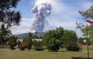
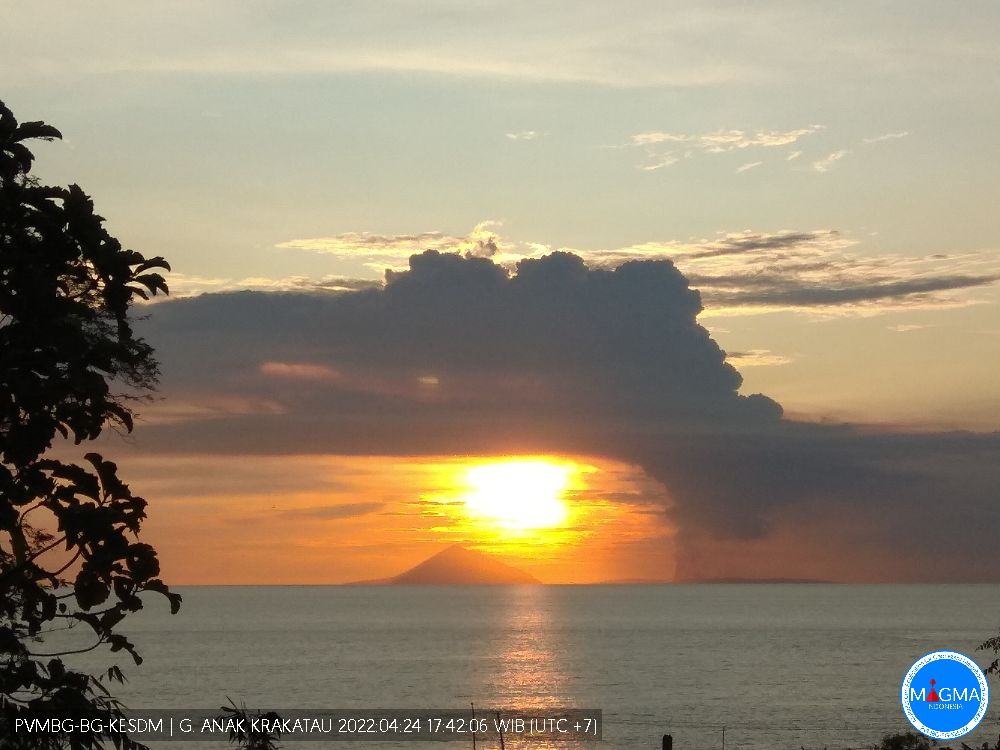
Indonesia , Anak Krakatau :
SIGNS OF INCREASED ACTIVITY AT ANAK KRAKATAU VOLCANO – JUNE 27, 2026.
Anak Krakatau is an active Type A volcano located in the waters of the Sunda Strait; administratively, it falls under the jurisdiction of South Lampung Regency in Lampung Province. However, monitoring of Anak Krakatau is conducted from two volcanological observation posts: the Anak Krakatau observation post in Kalianda (South Lampung Regency, Lampung Province) and the Pasauran post (Serang Regency, Banten Province).
Historical records document a major eruption in 1883 that generated a tsunami. Furthermore, on December 22, 2018, seismic tremors triggered an eruption and a partial collapse of the volcano’s structure, causing a tsunami in the Sunda Strait region. Following this event, a series of minor eruptions—marking a rebuilding phase for Anak Krakatau—continued until December 16, 2023. Although the volcano has entered a period of relative quiet since then, it continues to exhibit low-energy magmatic activity.
Since June 1, 2026, Sentinel satellite data have revealed sulfur dioxide (SO2) emissions and thermal anomalies, as well as the appearance of hotspots within the crater starting on June 10, 2026. These signs are accompanied by intense smoke emissions from the crater and a significant increase in earthquakes associated with shallow volcanic activity (specifically « gas-puffing » events, hybrid/multiphase events, and low-frequency events). On June 18 and 19, 2026, the frequency of these earthquakes (gas-emission, hybrid/multiphase, and low-frequency events) rose sharply, reaching an average of over 50 occurrences per day. Although unaccompanied by an increase in deep earthquakes (Type A and B volcanic quakes) or ground deformation, this rise in shallow-origin earthquakes indicates magmatic activity occurring in the immediate vicinity of the Anak Krakatau volcano’s surface.
Since June 26, 2026, the intensity of emission-related earthquakes has increased, accompanied by intensified discharges at the crater—specifically gray plumes containing light volcanic ash drifting west-northwest. These plumes have been detected by satellites operated by the Volcanic Ash Advisory Centre (VAAC) in Darwin, Australia.
These signs of increased shallow magmatic activity could signal an escalation in Anak Krakatau’s activity, potentially leading to an eruption. In the event of an eruption, potential hazards include pyroclastic flows, lava flows, the ejection of incandescent rocks, and significant ashfall. To date, this intensification of shallow magmatic activity has not resulted in a change to the volcano’s official alert level; consequently, Anak Krakatau remains at Level II (Advisory/Waspada).
Source : PVMBG.
Photo : PVMBG ( archive )
Colombia , Galeras :
San Juan de Pasto, June 23, 2026, 2:50 PM
Based on monitoring of activity at the Galeras volcano, the Colombian Geological Service (SGC)—an agency under the Ministry of Mines and Energy—reports the following:
During the week of June 16 to 22, 2026, the main changes in monitored parameters compared to the previous week were as follows:
● Amidst a period of low volcanic activity, a decrease was recorded in both the frequency of events and the seismic energy released. The majority
of this seismicity remained associated with rock-fracturing processes within the volcanic edifice.
● Fracturing events were primarily located near the main crater. These events occurred at depths ranging from 1 to 3 km
below the summit of the Galeras volcano (4,200 meters above sea level) and had magnitudes of less than 1.2.
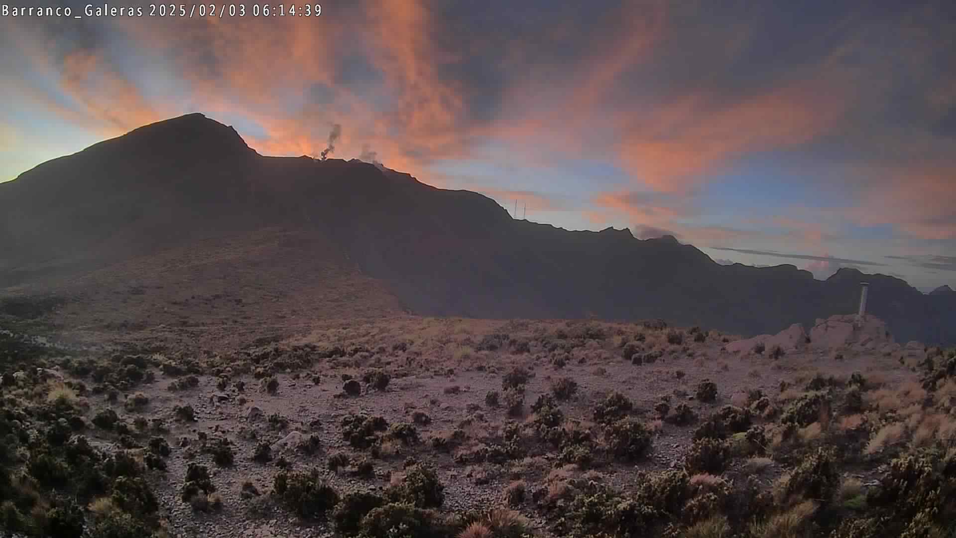
● Intermittent emissions of white gas were observed, characterized by low plume height and dispersion patterns that varied with wind direction. These emissions originated primarily from the fumarole fields at El Paisita (to the north) and Las Chavas (to the west), as well as from the main crater.
● Other volcanic monitoring parameters remained stable.
In light of the above, the SGC recommends closely monitoring the volcano’s activity via weekly bulletins and other information released through official channels, and adhering to the guidelines issued by local and departmental authorities and the National Unit for Disaster Risk Management (UNGRD).
Volcanic activity remains at the yellow alert level: an active volcano showing changes in the baseline behavior of monitored parameters and other manifestations.
Source et photo : SGC.