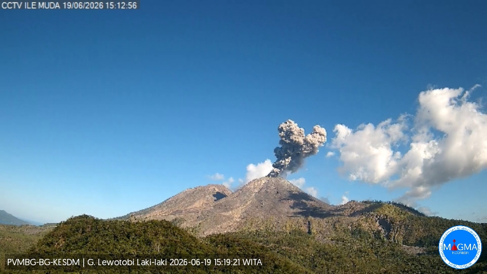
June 20 , 2026.
Indonesia , Lewotobi Laki-laki :
An eruption of Mount Lewotobi Laki-laki occurred on Friday, June 19, 2026, at 3:15 PM WITA. The observed ash column rose approximately 1,000 meters above the summit (approximately 2,584 meters above sea level). This ash column was gray and very dense, oriented to the west and northwest. The eruption was recorded by a seismograph with a maximum amplitude of 1,000 mm and a duration of 168 seconds.
Seismic Observations
One eruption earthquake with a magnitude of 47.3 mm and a duration of 50 seconds.
Two emission earthquakes with magnitudes ranging from 3.7 to 11 mm and a duration of 53 to 66 seconds.
Six non-harmonic tremors with magnitudes ranging from 2.9 to 4.4 mm and a duration of 42 to 95 seconds.
Two low-frequency earthquakes with magnitudes ranging from 4.4 to 5.9 mm and a duration of 19 to 28 seconds.
Recommendations
1. Residents living near Mount Lewotobi Laki-laki and visitors/tourists are advised to avoid all activity within a 5 km radius of the eruption epicenter.
2. The population is urged to remain calm, follow the instructions of local authorities and disregard rumors from unknown sources.
Source et photo : PVMBG.
Colombia , Galeras :
San Juan de Pasto, June 16, 2026, 5:20 PM
Regarding the monitoring of activity at the Galeras volcano, the Colombian Geological Survey (SGC), an agency under the Ministry of Mines and Energy, reports the following:
During the week of June 9-15, 2026, the main variations in monitored parameters, compared to the previous week, were as follows:
● In a context of low volcanic activity, an increase in the frequency of seismic events was recorded, accompanied by a decrease in the total energy released. Most of this seismicity remained associated with fracturing processes within the volcanic edifice.

● Most fracturing occurred near the main crater, with some occurring to the south and northeast of the volcanic edifice. These events took place at depths between 0.5 and 10 km from the summit of Galeras Volcano (4,200 m above sea level), with a magnitude of less than 2.
● White gas emissions were observed, characterized by their low altitude and a dispersion direction that varied with wind direction. These emissions originated primarily from the fumarole fields of El Paisita to the north, Las Chavas to the west, and the main crater.
● Other volcanic monitoring parameters remained stable.
In light of the above, the Geological Survey of Colombia (SGC) recommends closely monitoring the situation by consulting weekly bulletins and other information published through its official channels, as well as following the instructions of local and departmental authorities and the National Unit for Disaster Risk Management (UNGRD). Volcanic activity remains at the yellow alert level: Active volcano with changes in the baseline behavior of monitored parameters and other manifestations.
Source et photo : SGC.
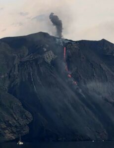
Chile / Argentina , Planchon Peteroa :
SPECIAL REPORT ON VOLCANIC ACTIVITY, June 19, 2026
The Argentine Geological and Mining Service (SEGEMAR), through its Argentine Volcanic Monitoring Observatory (OAVV), reports that today, Friday, June 19, 2026, at 12:47 local time (3:47 PM UTC), the volcanic monitoring stations located near the Planchón-Peteroa volcanic complex recorded a long-period (LP) seismic event associated with fluid movement within the volcanic system and characterized by its high energy.
Event Information
Origin Time: 12:47 local time (3:47 PM UTC)
Reduced Displacement: 266.6 cm²

OBSERVATIONS:
At the time of publication of this report, lower-energy LP seismic activity continues to be recorded. No other changes have been observed in the monitoring parameters of this volcanic complex.
CONCLUSIONS:
The technical alert level remains in effect, and monitoring of the volcano will continue in constant communication with the Southern Andes Volcanological Observatory (OVDAS) of Chile, as well as with local, provincial, and national civil protection authorities, within the framework of the National Integrated Risk Management System (SINAGIR) through the Federal Emergency Management Agency (AFE).
Source et photo : Segemar .
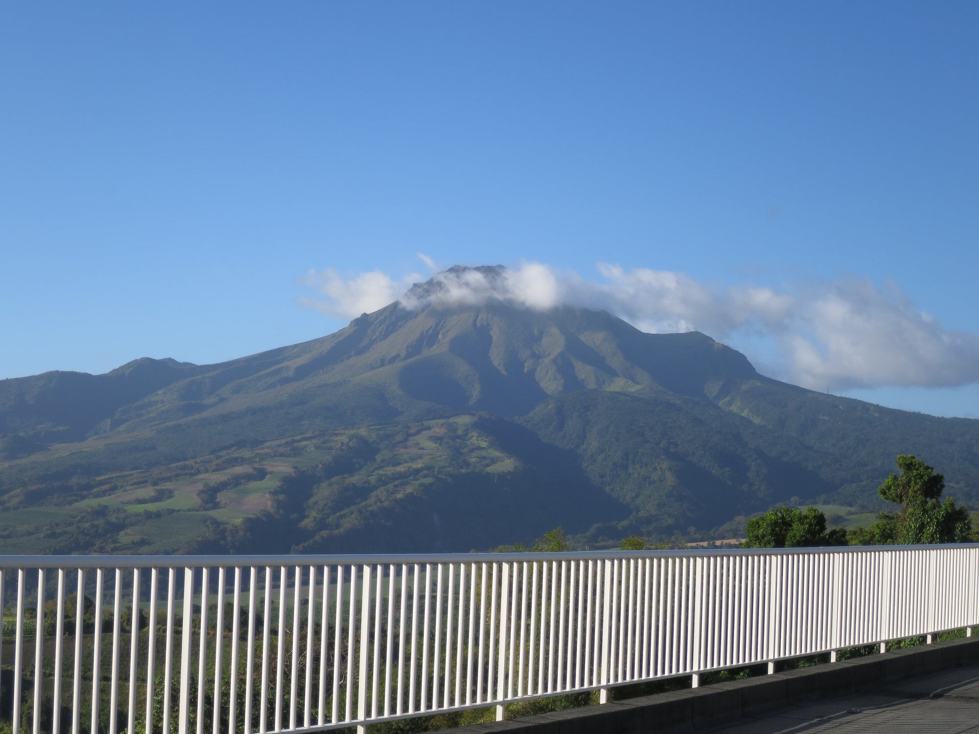
La Martinique , Mount Pelée :
Weekly Report, Paris Institute of Earth Physics / Martinique Volcanological and Seismological Observatory
Saint-Pierre, June 19, 2026, 3:15 PM local time (GMT-4)
Between June 12, 2026, 4:00 PM UTC and June 19, 2026, 4:00 PM UTC, the Martinique Volcanological and Seismological Observatory (OVSM) recorded 115 volcanic earthquakes:
• 114 volcano-tectonic earthquakes. Among them, 24 had a magnitude (local magnitude Mlv or duration magnitude Md) greater than 0.5 and 8 had a magnitude greater than 1. The largest had a magnitude Mlv of 1.37. The others were of lower energy. The vast majority of these earthquakes were located at depths between 0.8 and 1.4 km below the volcano’s summit.
However, one earthquake was initially located at a depth of approximately 4.5 km below sea level, directly beneath Mount Pelée. This volcano-tectonic seismicity is associated with microfracturing within the volcanic edifice, linked to the overall reactivation of the volcano observed since 2019.
• One deep, long-period earthquake was located at a depth of 21 km south of Mount Pelée, with a magnitude of Mlv = 0.8. Deep, long-period earthquakes are characterized by signals containing only low frequencies and are associated with the circulation of magmatic fluids deep within the Mount Pelée volcanic system.
No earthquakes were felt by the population.
The previous week, the OVSM (Mountain Seismological Observatory of Madagascar) recorded 108 volcanic earthquakes. As of June 19, 2026, and over the past four weeks, the OVSM has observed a total of 412 volcanic earthquakes, an average of 103 earthquakes per week.
During periods of volcanic reactivation of volcanoes similar to Mount Pelée, seismic activity of varying intensity and frequency is common. The probability of an eruptive activity in the short term remains low. However, based on observations accumulated in recent years, and particularly in recent months, a change in the situation in the medium term (weeks to months) cannot be ruled out.
The volcanic alert level, in accordance with the measures put in place by the authorities, is currently YELLOW: vigilance.
Source et photo : Direction de l’OVSM-IPGP.
Costa Rica , Poas :
OVSICORI-UNA Volcano Weekly Monitoring Bulletin, June 19, 2026
Latitude: 10.20°N;
Longitude: 84.23°W;
Elevation: 2,687 m
Current Activity Level: Alert
No eruptions were recorded this week. Tremor amplitude increased Wednesday evening and exhibited spectral variability, with episodes of monochromatic tremor corresponding to the highest amplitudes. The number of long-period events continues to decrease. No volcano-tectonic earthquakes were recorded this week. High-frequency events were recorded at stations near the crater. The geodetic network did not detect any net deformation, although crater contraction was observed. A slight increase in the SO₂/CO₂ ratio was recorded, rising from approximately 1.3 last week to 1.7 this week.
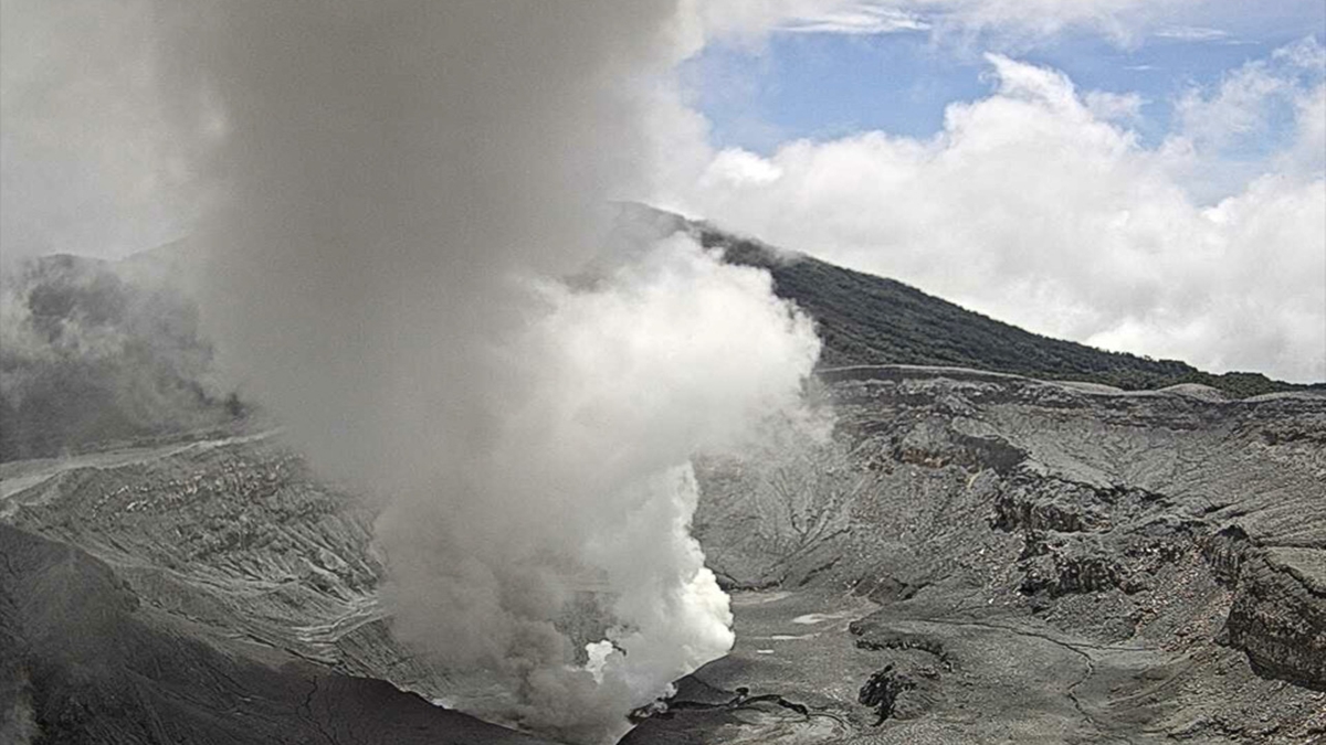
The H₂S/SO₂ ratio remains below 0.1. NOVAC stations recorded 154 ± 72 tonnes of SO₂ per day, a higher flow rate than the previous week (40 ± 45 t/d). The SENTINEL satellite detected the SO₂ plume on several occasions, reaching a peak of 27.5 tonnes on June 14. The level of the hyperacidic lake continues to rise slowly. Between February 2025 and June 2026, the hyperacidic Poás Lake exhibited a chemical composition richer in chloride ions than sulfate ions, similar to that observed in 2023. It is worth noting that the sulfate ion concentration was higher during the first half of 2024, due to increased injections of fresh SO₂ into the hydrothermal system that forms the lake.
Source et photo : Ovsicori.