June 19 , 2026.
Italy / Sicily , Etna :
The Sezione di Catania – Osservatorio Etneo (INGV) reported minor eruptive activity at Etna’s summit craters beginning on 14 June. A Volcano Observatory Notice to Aviation (VONA) was issued at 1135 on 14 June raising the Aviation Color Code (ACC) to Yellow (the second lowest color on a four-color scale) due to unrest above background levels. Diffuse ash emissions occurred on 15 June, prompting the INGV to raise the ACC to Orange. Ashfall did not occur beyond the summit area. Minor ash emissions continued at least through 17 June.
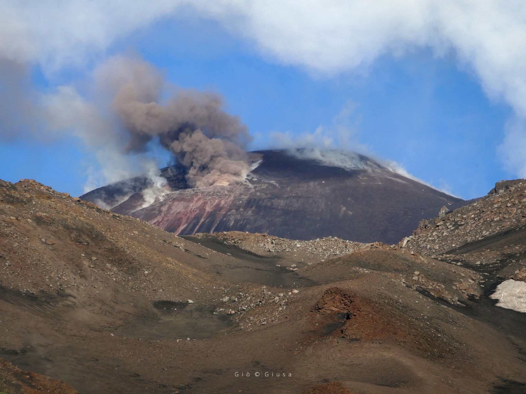
Since the morning of June 10, 2026, a new, albeit weak, explosive activity was observed on December 27, 2025, at the top of the Voragine crater on Mount Etna. There have been sporadic emissions of ash, primarily composed of older material (brown, reddish, gray) sometimes mixed with small amounts of incandescent fragments. This is the first magmatic activity with the arrival of incandescent material on Etna in five months, following the cessation of effusive activity in the Valle del Bove. Is this the beginning of a new period of spectacular activity? Of course, sooner or later the spectacle will unfold, but the current activity could also last for weeks with little variation, or stop again, and then resume with renewed intensity. For the moment, the monitored signals do not indicate any major activity imminent. Let us remember that exactly two years ago, on June 14, 2024, very weak Strombolian activity began in the same Voragine volcano, which in a few weeks evolved through spectacular lava flows towards the Bocca Nuova crater and culminated in six enormous paroxysms…
Sources : Sezione di Catania – Osservatorio Etneo (INGV) , INGV , Boris Behncke .
Photo : Gio Giusa .
Philippines , Kanlaon :
The Philippine Institute of Volcanology and Seismology (PHIVOLCS) reported continuing eruptive activity at Kanlaon during 10-17 June. The seismic network recorded 0-19 daily volcanic earthquakes; during 12-17 June the counts included 2-15 daily periods of volcanic tremor lasting one minute to nearly four hours each. Sulfur dioxide emissions ranged from 979 to 2,293 tonnes per day. Daily volcanic emissions generally rose as high as 1 km above the summit and drifted mainly NW, W, and SW.
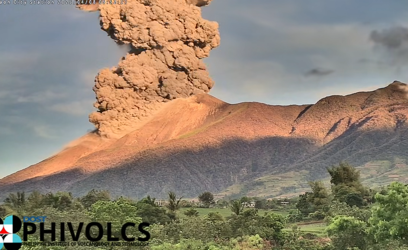
There were 1-12 daily periods of ash emissions during 12-17 June, each lasting as short as one minute to as long as three hours and 41 minutes. Specifically, the webcam recorded grayish ash emissions at 08h28 on 12 June, at 07h04 on 13 June, and at 08h58 and 17h21 on 16 June rising 300-600 m above the crater rim and drifting NW, W, and SW. At least 20 emissions were recorded during 15-16 June. The Alert Level remained at 2 (on a scale of 0-5); the public was warned to stay out of the 4-km-radius Permanent Danger Zone (PDZ) and pilots were advised to avoid flying close to the summit.
Sources: Philippine Institute of Volcanology and Seismology (PHIVOLCS), GVP.
Photo : Archive phivolcs.
Indonesia , Semeru :
Hot clouds descend over Mount Semeru, East Java.
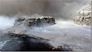
Mount Semeru, located in the Lumajang and Malang districts of East Java province, remains at Level III (SIAGA). Volcanic activity remains high, characterized by repeated pyroclastic avalanches.
Today, June 19, 2026, at 7:21 a.m. West Indonesia Time (WIB), an eruption occurred, followed by a pyroclastic ash plume that rose to 4,500 meters southeast of the summit. Visual and instrumental observations indicate that, from June 1 to 18, 2026, three pyroclastic ash plumes were observed to the southeast. Seismic activity has consisted mainly of eruptive earthquakes, avalanches, and harmonic tremors. Recorded earthquakes indicate that Mount Semeru retains a reserve of energy from its depths, as well as from material ejected onto the surface during eruptions.
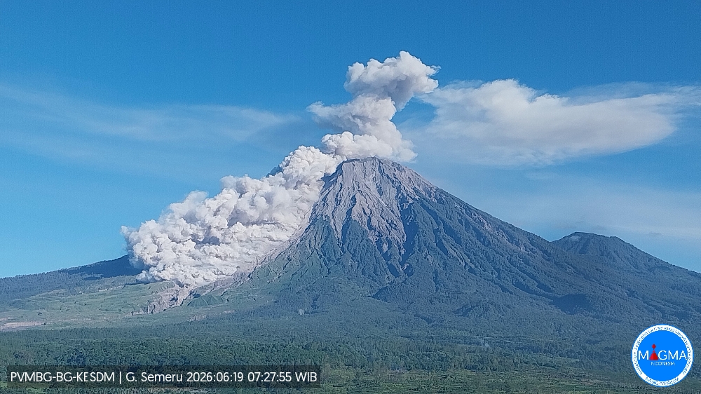
The seismic velocity variation parameter (dv/v) has hovered around zero since mid-February 2026, suggesting that the volcanic system is in a relaxation phase and is not undergoing pressurization, while remaining highly vulnerable to pressure increases. Deformation monitoring data reveals relative stability, indicating the absence of pressure increases within the volcano and a constant pressure transfer from the interior to the surface, accompanied by the ejection of material during eruptions.
Following analysis and assessment, the activity level of Mount Semeru remains at Level III (SIAGA). The primary recommendation is to prohibit all public, visitor, and mountaineering activity within a 5-kilometer radius of the Jonggring Saloko crater and to avoid the southeast sector, which extends 13 kilometers southeast from the summit and up to 17 kilometers along the Besuk Kobokan River. The public is advised of the risks of hot clouds, lava flows and lahars along the rivers and valleys originating at the summit of Mount Semeru, particularly along the Besuk Kobokan, Besuk Bang, Besuk Kembar and Besuk Sat rivers, as well as the risks of lahars in the small tributary streams of the Besuk Kobokan.
Source et photo : PVMBG.
Japan , Sakurajima :
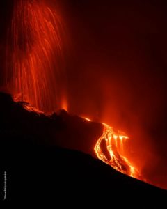
The Japan Meteorological Agency (JMA) reported ongoing eruptive activity at Minamidake Crater (Aira Caldera’s Sakurajima volcano) during 8-15 June. Explosions at 21h41 on 8 June, and at both 15h55 and 21h39 on 11 June, generated ash plumes that rose 400-800 m above the summit and drifted SE and E with blocks ejected 500-700 m from the vent. Sulfur dioxide emissions were slightly above normal, averaging 1,400 tons per day on 12 June. Very small eruptive events and nighttime crater incandescence were recorded during 12-15 June. The Alert Level remained at 3 (on a 5-level scale), and the public was warned to be cautious within 2 km of both the Minimadake and Showa craters.
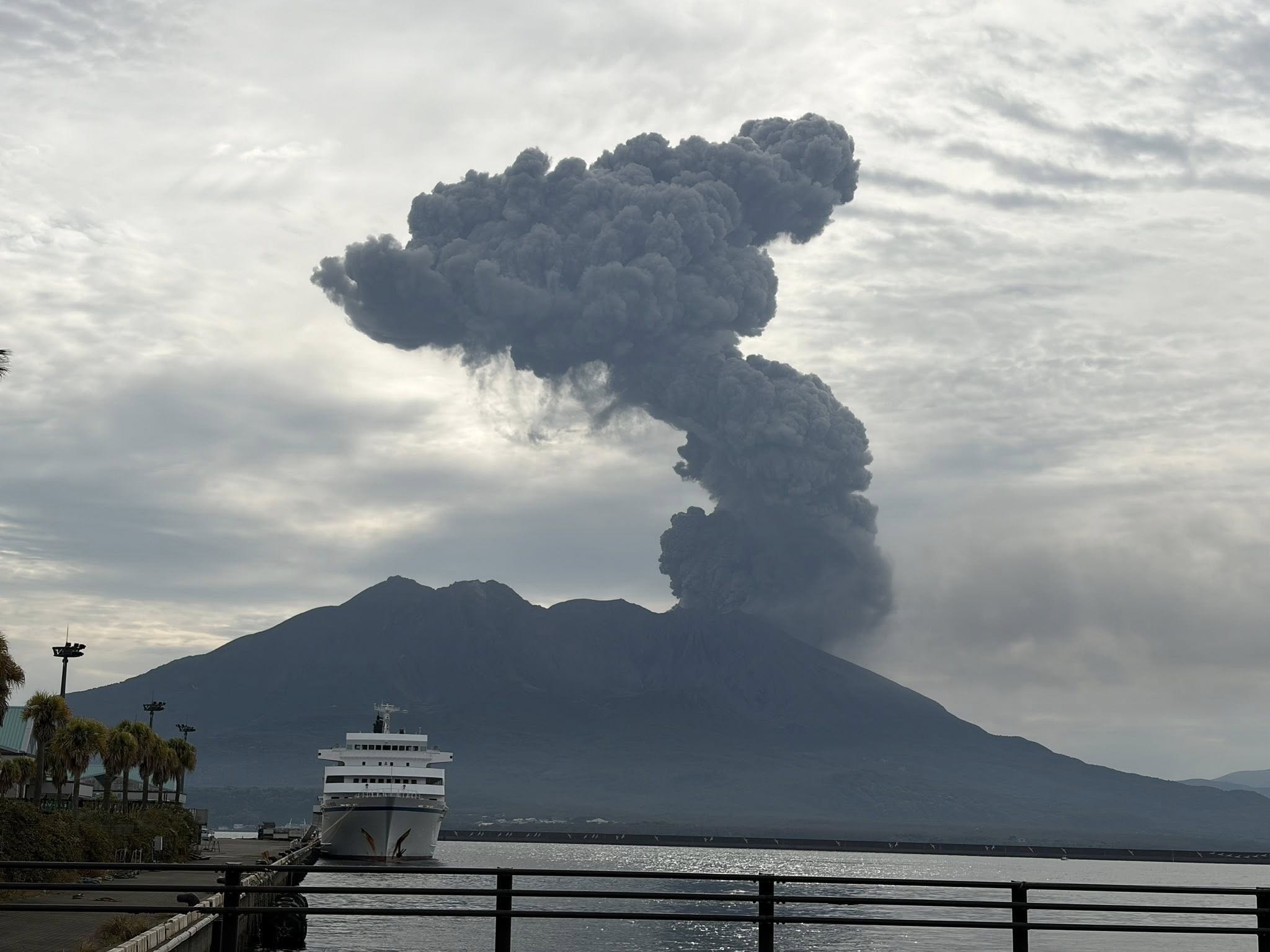
The Aira caldera in the northern half of Kagoshima Bay contains the post-caldera Sakurajima volcano, one of Japan’s most active. Eruption of the voluminous Ito pyroclastic flow accompanied formation of the 17 x 23 km caldera about 22,000 years ago. The smaller Wakamiko caldera was formed during the early Holocene in the NE corner of the caldera, along with several post-caldera cones. The construction of Sakurajima began about 13,000 years ago on the southern rim and built an island that was joined to the Osumi Peninsula during the major explosive and effusive eruption of 1914. Activity at the Kitadake summit cone ended about 4,850 years ago, after which eruptions took place at Minamidake. Frequent eruptions since the 8th century have deposited ash on the city of Kagoshima, located across Kagoshima Bay only 8 km from the summit. The largest recorded eruption took place during 1471-76.
Sources: Japan Meteorological Agency (JMA) , GVP.
Photo : Hanna Hanna.
Iceland , Bárdarbunga :
The Icelandic Meteorological Office (IMO) reported that an intense seismic swarm began at Bárdarbunga on 13 June in the NW part of the caldera. A M 2.6 earthquake and an M 4.8 earthquake were recorded at 20h10 and 20h14, respectively; both events were located at depths of 2-4 km. The events were followed by several more earthquakes above M 3 and more than 180 smaller earthquakes by 00h43 on 14 June. The Aviation Color Code (ACC) was raised to Yellow (the second lowest color on a four-color scale). The swarm began to decrease in intensity by 03h00; by 08h46 about 400 earthquakes in total had been detected. The seismic activity did not escalate; only 14 minor earthquakes with magnitudes of 0.9 or lower were detected from around mid-morning on 14 June to 12h42 on 15 June with the activity characterized as at background. The ACC was lowered to Green. IMO noted that the last comparable swarm occurred in January 2025.
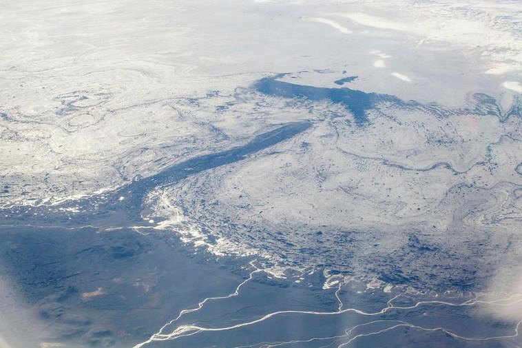
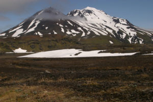
The large central volcano of Bárðarbunga lies beneath the NW part of the Vatnajökull icecap, NW of Grímsvötn volcano, and contains a subglacial 700-m-deep caldera. Related fissure systems include the Veidivötn and Trollagigar fissures, which extend about 100 km SW to near Torfajökull volcano and 50 km NE to near Askja volcano, respectively. Voluminous fissure eruptions, including one at Thjorsarhraun, which produced the largest known Holocene lava flow on Earth with a volume of more than 21 km3, have occurred throughout the Holocene into historical time from the Veidivötn fissure system. The last major eruption of Veidivötn, in 1477, also produced a large tephra deposit. The subglacial Loki-Fögrufjöll volcanic system to the SW is also part of the Bárðarbunga volcanic system and contains two subglacial ridges extending from the largely subglacial Hamarinn central volcano; the Loki ridge trends to the NE and the Fögrufjöll ridge to the SW. Jökulhlaups (glacier-outburst floods) from eruptions at Bárðarbunga potentially affect drainages in all directions.
Sources: Icelandic Meteorological Office (IMO) , GVP.