June 10 , 2026.
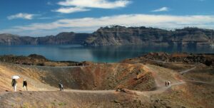
Italy , Stromboli :
WEEKLY BULLETIN, June 1, 2026 to June 7, 2026. (Issuance date: June 9, 2026)
ACTIVITY SUMMARY
Based on monitoring data, the following points should be noted:
1) VOLCANOLOGICAL OBSERVATIONS: Ordinary Strombolian-type eruptive activity, coupled with ejections of varying intensity in the North Crater area. Average daily hourly frequency of moderate intensity, moderate intensity in the North Crater area and high intensity in the Central-South Crater area.
2) SEISMOLOGY: Monitored seismic parameters show no significant variation.
3) GROUND DEFORMATION: The GNSS network did not measure any significant variations during the week.
4) GEOCHEMISTRY: SO₂ flux at a moderate level.
CO₂ flux from the ground in the Pizzo area (STR02): No update.
C/S ratio in the plume: Remained at medium to high values over the past week.
Helium isotope ratio (R/Ra) dissolved in the thermal aquifer: Data from the last sample taken on April 29, 2026, indicate very high values (R/Ra = 4.50).
CO₂ flux from the ground in the San Bartolo area: At high and very high values.
CO₂ flux from the ground in the Scari area: At medium values.
5) SATELLITE OBSERVATIONS: Satellite-observed thermal activity in the summit area was generally low, with a few isolated anomalies of moderate intensity.
VOLCANOLOGICAL OBSERVATIONS
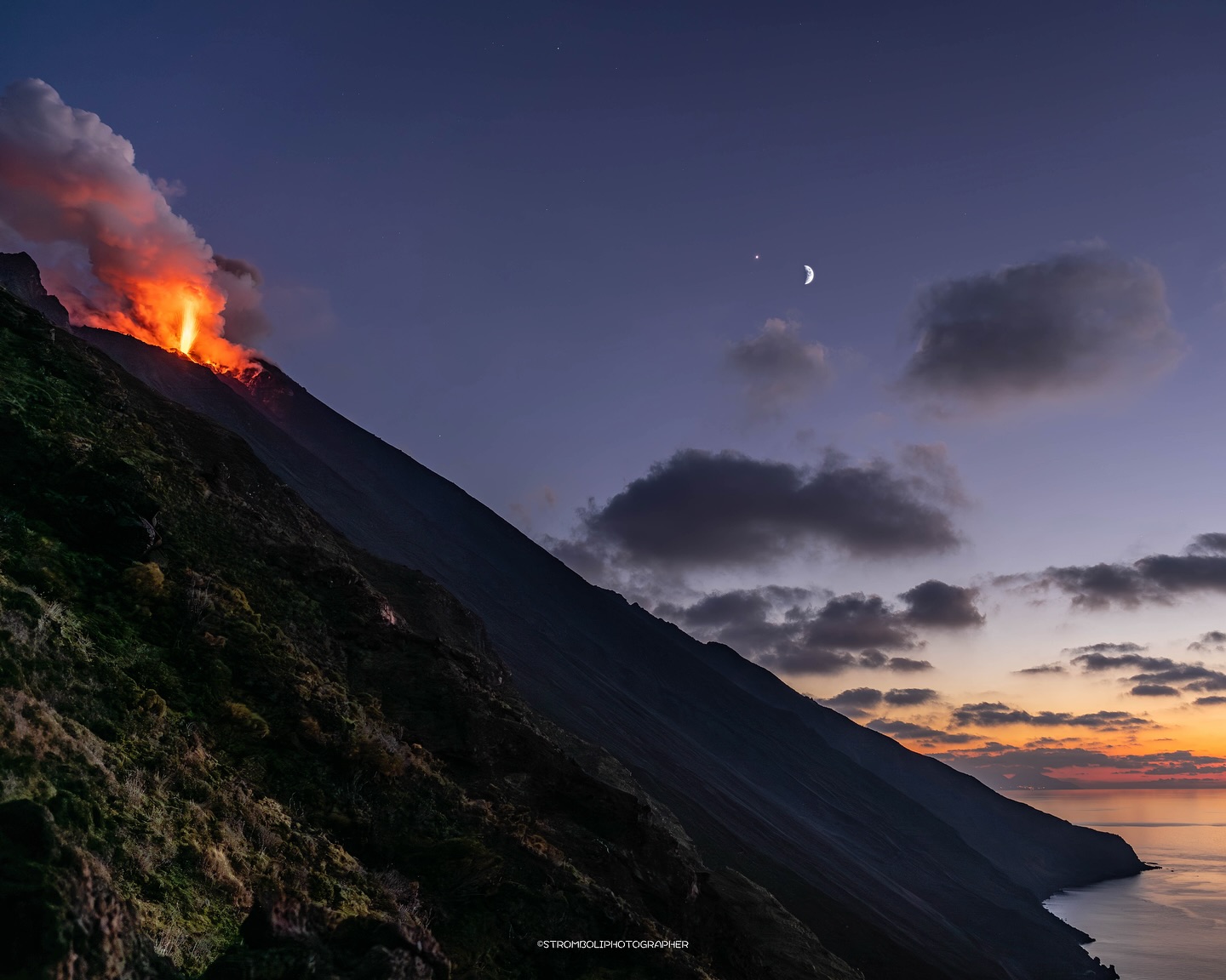
During the week of observation, Stromboli’s eruptive activity was characterized by the analysis of images recorded by the INGV-OE surveillance cameras, located at an altitude of 190 m and at Punta dei Corvi (SCT-SCV and SPCT, respectively). Explosive activity was primarily produced by five eruptive vents located in the North Crater area (N1) and by at least two vents located in the Central-South area.
Observations of explosive activity captured by surveillance cameras
The average daily hourly frequency of explosions was average, with a slight increase between June 4 and 5. Explosions in the North Crater area were fed by five active vents, two in sector N1 and three in sector N2, which produced mainly coarse material (bombs and lapilli). The average frequency of explosions in the North area was average, with an average intensity. In the Central-South crater area, two explosive vents were observed, producing fine materials mixed with coarse materials; the average frequency of explosions was low, with intensity remaining at a high level, between June 4 and 5 and between June 7 and 8.
Source : INGV.
Photo : Stromboli stati d’animo / Sebastiano Cannavo
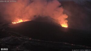
Iceland , Reykjanes Peninsula :
Ground uplift and magma accumulation continue beneath Svartsengi
Updated 9 June 2026
Uplift at Svartsengi continues at a steady rate
Around 27.5 million cubic metres of magma have accumulated since around mid-July last year
Seismic activity remains low
The hazard assessment remains unchanged and is valid until 30 June

Deformation
Uplift and magma accumulation continue at Svartsengi, and the trend remains stable. The latest model calculations indicate that around 27.5 million cubic metres of magma have accumulated beneath Svartsengi since around mid-July last year.
Seismic activity
Seismic activity along the Sundhnúksgígar crater row and in the vicinity of Grindavík remains low. No significant change in seismic activity has been observed since the last update.
Hazard assessment
The Icelandic Meteorological Office’s hazard assessment remains unchanged and is valid until 30 June, unless there are changes in activity. The IMO’s 24-hour monitoring team continues to follow developments closely.
Source : IMO
Photo : Bar Harel.
Indonesia , Dukono :
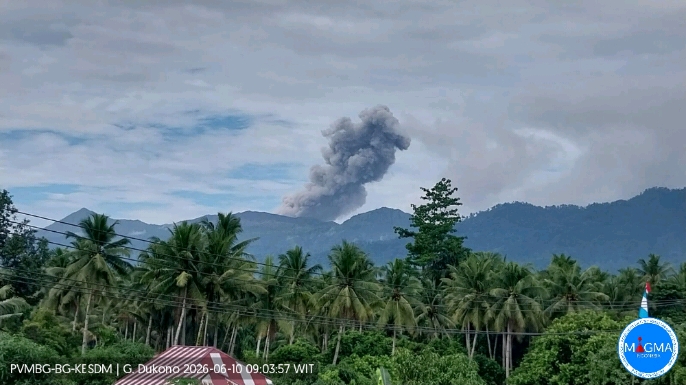
An eruption of Mount Dukono occurred on Wednesday, June 10, 2026, at 08:56 WIT, with an observed ash column height of approximately 1000 m above the summit (approximately 2087 m above sea level). This ash column, white to gray in color, was highly intense and directed northwest. The eruption was recorded by a seismograph with a maximum amplitude of 13 mm and a duration of 43.3 seconds.
Seismic Observations
84 eruption earthquakes with amplitudes between 7 and 34 mm and durations from 50.08 to 186.46 seconds.
45 low-frequency earthquakes with amplitudes between 4 and 5 mm and durations from 30.02 to 48.03 seconds.
Two distant tectonic earthquakes with amplitudes between 6 and 7 mm and durations from 100.31 to 143.7 seconds.
Continuous seismic tremor with amplitudes between 1 and 6 mm, predominantly 2 mm.
Recommendations
(1) Residents living near Mount Dukono and visitors/tourists are advised to refrain from any activity, climbing, or approaching the Malupang Warirang crater within a 4 km radius.
(2) Considering that eruptions with volcanic ash occur periodically and that the distribution of ash follows the direction and speed of the wind, so that the area where the ash lands is not constant, people living around Mount Dukono are advised to always carry masks/face coverings and mouth coverings to use when needed to avoid the threat that volcanic ash poses to the respiratory system.
Source et photo : PVMBG.
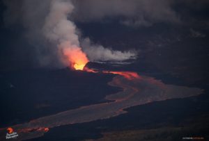
Colombia , Puracé – Los Coconucos volcanic chain :
Popayán, June 9, 2026, 2:30 PM
Regarding the monitoring of activity at the Puracé volcano – Los Coconucos volcanic chain, the Geological Survey of Colombia (SGC), an agency under the Ministry of Mines and Energy, reports the following:
During the week of June 2-8, 2026, variations in seismic activity continued to be recorded, characterized by an increase in energy released and a higher frequency of events related to fluid dynamics within the volcanic system, primarily continuous tremor (TR) and tremor pulses. This seismicity was mainly located beneath the craters of the Puracé and Piocollo volcanoes, at depths of less than 3 km, and was associated with fluid circulation processes, the release of volcanic gases, and ash emissions into the atmosphere from the Puracé volcano crater. During the assessment period, the ash plumes reached a height of 2 km above the volcano’s summit and dispersed primarily towards the western and northwestern sectors of the crater, following the prevailing wind direction. As a result, ashfall was reported in several rural areas of the municipality of Puracé, including Hato Viejo, Ambiró, Patico, Pululó, Chapío, Cristales, Campamento, 20 de Julio, Anambío, Loma Linda, and the municipal capital, Coconuco. Ashfall was also reported in some neighborhoods of the city of Popayán and its surrounding rural area.
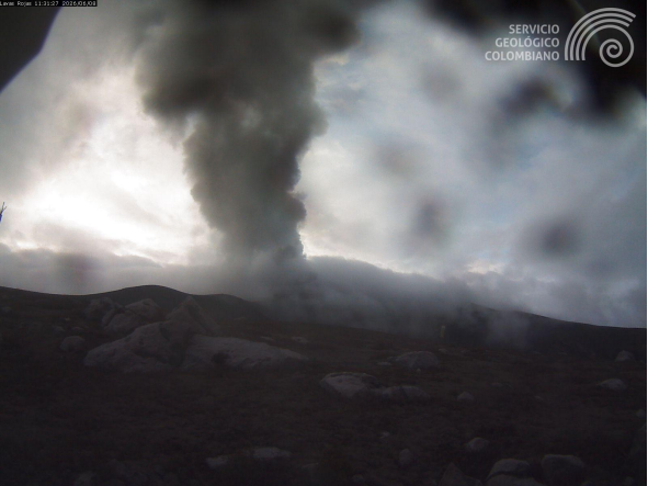
Recording from the Lavas Rojas camera, located 2.4 km northwest of the Puracé volcano, showing the ash emission of June 8, 2026, at 6:31 a.m.
Furthermore, seismicity associated with rock fracturing (VT) and hybrid events (HB) showed a slight increase in the number of events and the seismic energy released compared to previous weeks. These earthquakes, located mainly between the Puracé and Piocollo volcanoes at depths between 1 and 4 km, reached a magnitude of 2.2.
Images captured by satellite sensors and visible and infrared webcams revealed the persistence of thermal anomalies inside the Puracé volcano crater and in the fumarole field located on its outer rim, as well as degassing phenomena in the craters of the Puracé and Curiquinga volcanoes. Sulfur dioxide (SO₂) emissions into the atmosphere remain high. During this week, a slowdown in the deformation process was observed in the area between the Puracé, Piocollo, and Curiquinga volcanoes.
In conclusion, the variations observed at the Puracé volcano – part of the Los Coconucos volcanic chain – indicate that the system continues to evolve and that further ash emissions and fallout are possible, dispersed according to the prevailing wind direction. Furthermore, the possibility of additional changes in volcanic activity, potentially leading to more significant surface manifestations, cannot be ruled out. The public is advised to avoid the upper reaches of the volcanic chain and to remain attentive to official bulletins from the Geological Survey of Colombia (SGC).
The alert level for volcanic activity remains yellow: Active volcano with changes in the basic behavior of monitored parameters and other manifestations.
Source et photo : SGC.
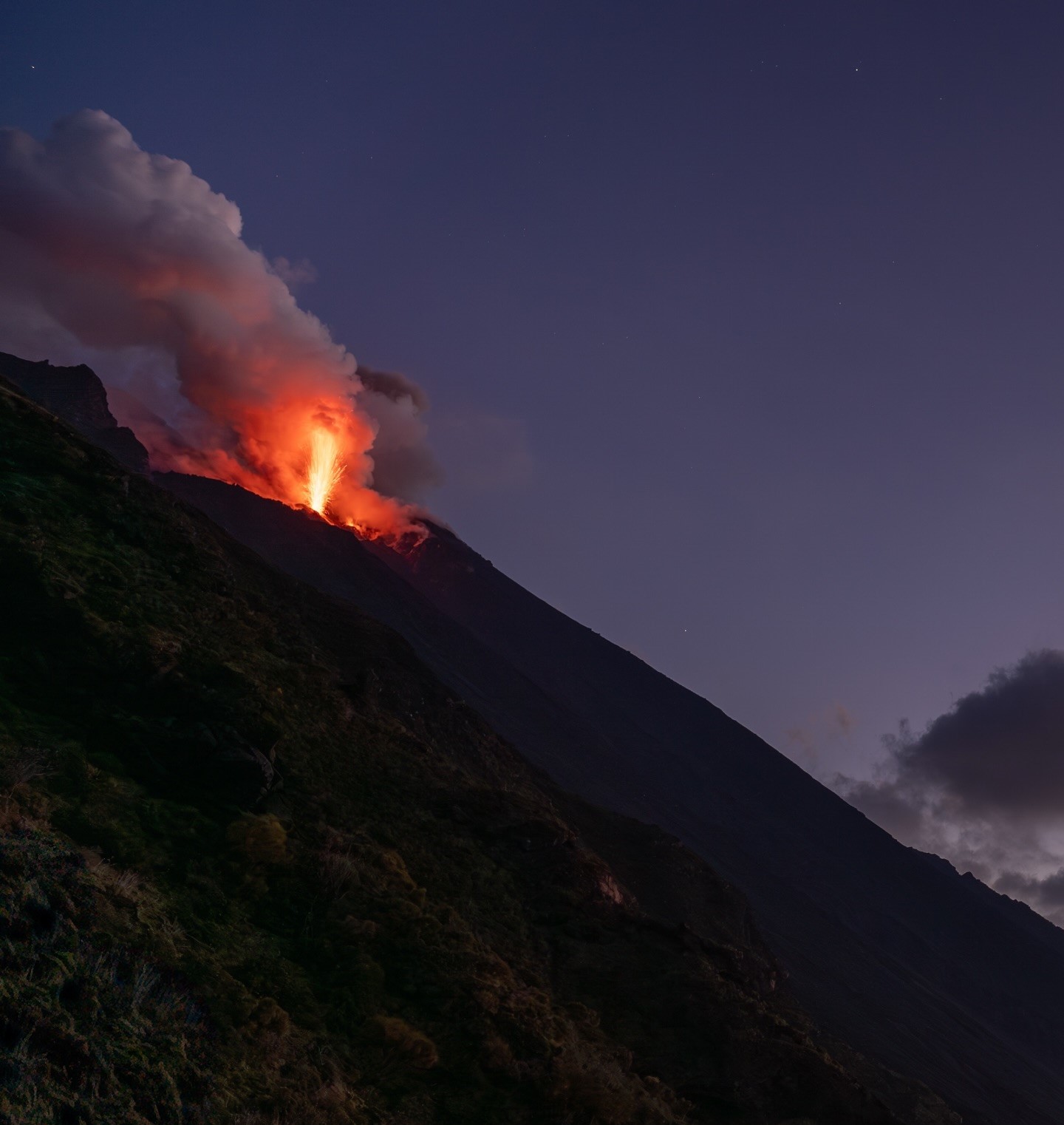
Peru , Sabancaya :
Local date and time: June 8, 2026 – 12:15 PM. Bulletin analysis period: June 1-7, 2026
Volcanic alert level
Orange alert level: The volcano’s eruptive activity has increased significantly. Increased seismic activity, frequent explosions, and emissions of ash and ballistic fragments have been observed.
Conclusions
The IGP reports that the eruptive process of Sabancaya volcano continues. During this period, a volcanic explosion was detected, generating columns of ash, water vapor, and gas up to 2,500 meters above the volcano’s summit, in addition to seismic activity associated with the movement of magmatic fluids and internal fracturing. Therefore, the volcanic alert level remains orange.

Recommendations
Adopt prevention and preparedness measures in accordance with the current orange volcanic alert level.
Do not approach within 12 km of the crater. In case of ashfall, cover your nose and mouth with damp cloths or a mask. Keep doors and windows closed.
Stay informed about Sabancaya’s volcanic activity through reports and bulletins published by the IGP (Geneva Institute of Public Health).
Outlook
The occurrence of future volcanic explosions generating eruptive columns over 2 km high is considered likely, with a risk of impact on districts in the Colca Valley and surrounding areas due to the dispersal of volcanic ash. Therefore, the volcanic alert level remains orange.
Source et photo : IGP.