June 8 , 2026.
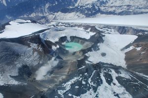
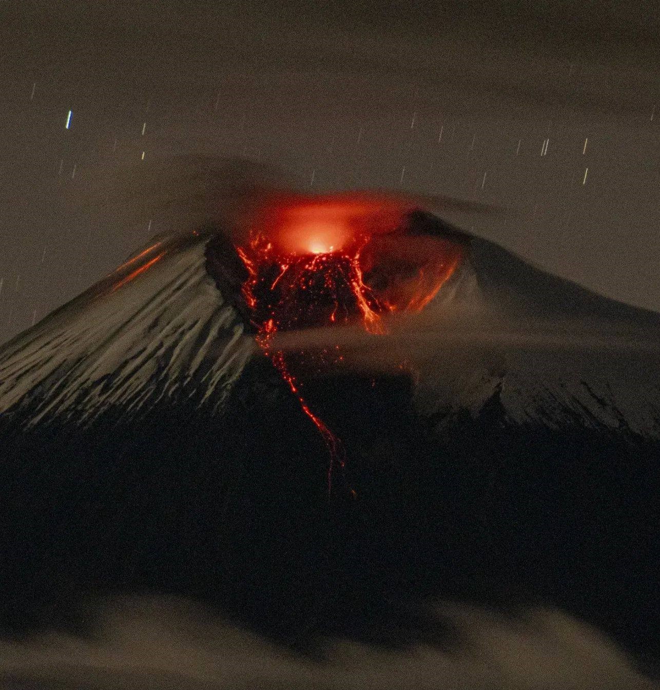
Kamchatka , Sheveluch :
KVERT VOLCANIC ACTIVITY NOTICE (VAN)
Issued: 20260608/0452Z
Volcano: Sheveluch (CAVW #300270)
Current aviation colour code: RED
Previous aviation colour code: orange
Source: KVERT
Notice Number: 2026-55
Volcano Location: N 56 deg 38 min E 161 deg 19 min
Area: Kamchatka, Russia
Summit Elevation: 3283 m (10768.24 ft), the dome elevation ~2500 m (8200 ft)
Volcanic Activity Summary:
The explosive-extrusive eruption of the volcano continues, accompanied by powerful gas-steam activity; a new block of lava continues to grow in the northern part of the lava dome. According to video data by KVERT, a powerful explosive event with ash removal up to 10 km a.s.l. (sart at 04:39 UTC on 08 June) is observing at now, ash cloud move to the northwest of the volcano.
The explosive-extrusive eruption of the volcano continues. Ash explosions up to 12 km (39,400 ft) a.s.l. could occur at any time. Ongoing activity could affect international and low-flying aircraft.
Volcanic cloud height:
10000 m (32800 ft) AMSL Time and method of ash plume/cloud height determination: 20260608/0444Z – Video data
Other volcanic cloud information:
Distance of ash plume/cloud of the volcano: 10 km (6 mi)
Direction of drift of ash plume/cloud of the volcano: NW
Time and method of ash plume/cloud determination: 20260608/0450Z – Video data
Duration of explosion: ~ 15 min
Source : Kvert
Photo : Viktor Frolov , Institut de volcanologie et de sismologie DVO RAN, @IViS_DVO_RAN
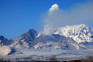
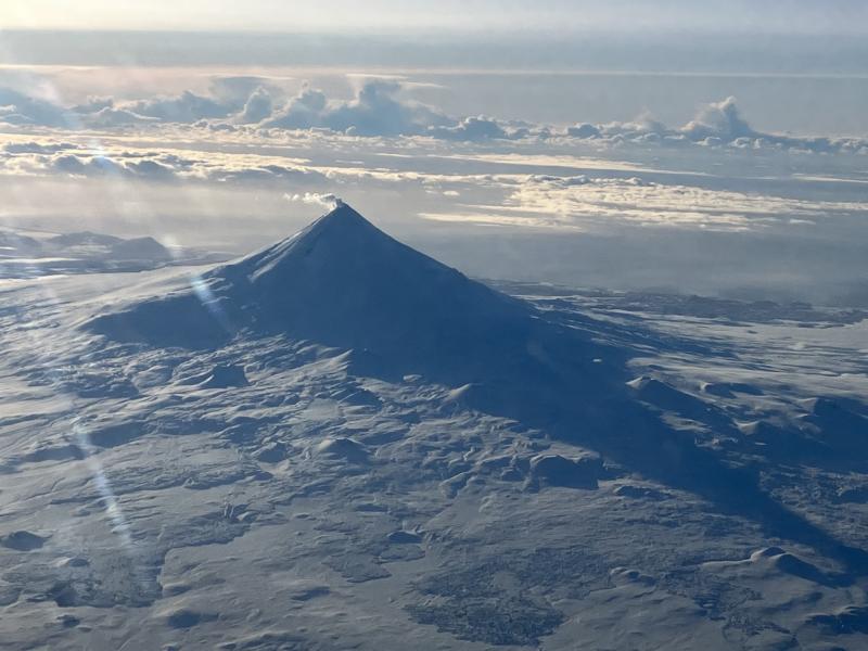
Alaska , Shishaldin :
Unrest continues. Minor seismic activity and infrasound were detected at the volcano. Numerous pilot reports of steam emissions were received yesterday afternoon. The plume was longer than usual, but this is likely due to favorable atmospheric conditions and not increased volcanic gas emissions. Satellite data from yesterday afternoon showed typical sulfur dioxide emissions from the volcano. No other activity was observed in satellite data.
Local seismic and infrasound sensors, web cameras, and a geodetic network are used to monitor Shishaldin Volcano. In addition to the local monitoring network, AVO uses nearby geophysical networks, regional infrasound and lightning data, and satellite images to detect eruptions.
Source : AVO
Photo : Beesley, Nick.
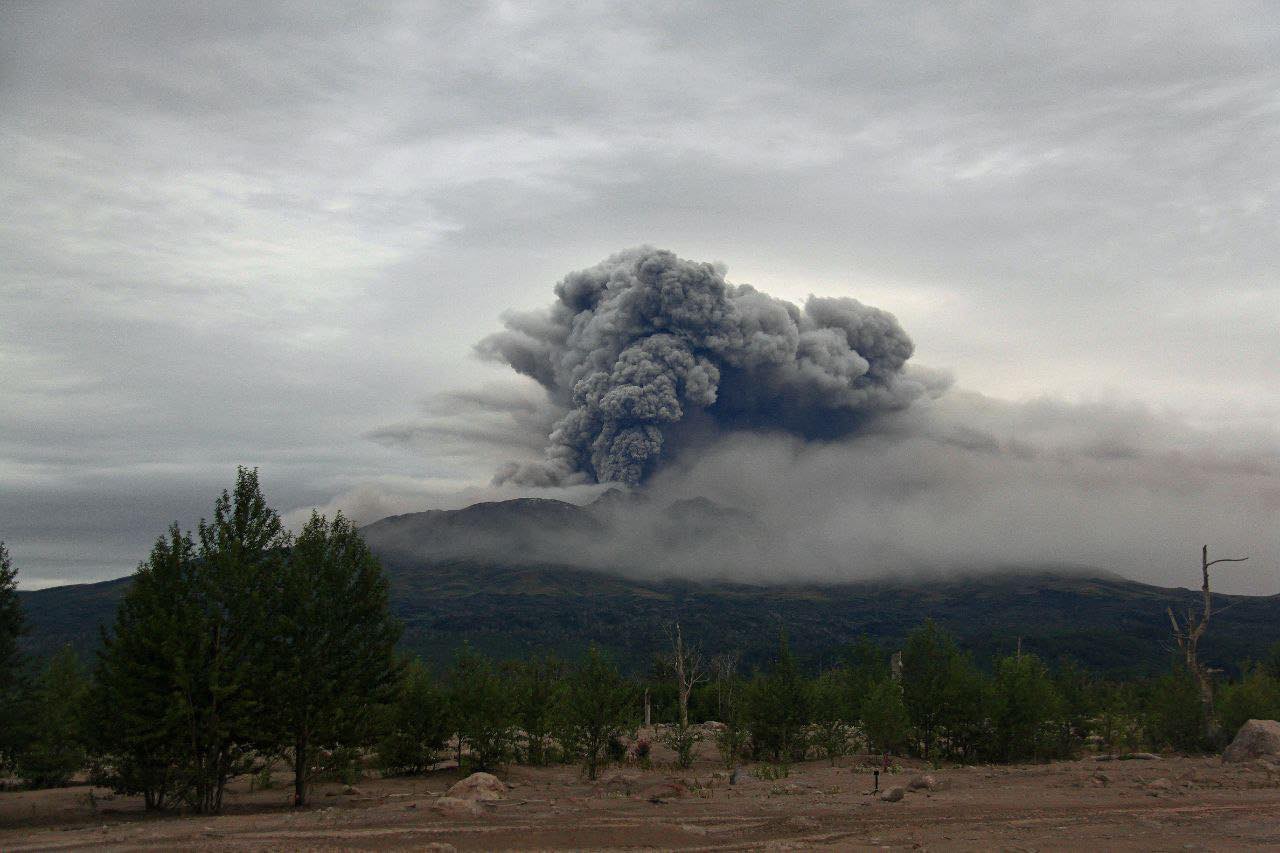
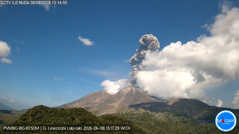
Indonesia , Lewotobi Laki-laki :
An eruption of Mount Lewotobi Laki-laki occurred on Monday, June 8, 2026, at 1:12 PM WITA. The observed ash column rose to approximately 2,200 m above the summit (approximately 3,784 m above sea level). This ash column was gray and dense, oriented to the west and northwest. The eruption was recorded by a seismograph with a maximum amplitude of 47.3 mm and a duration of 83 seconds.
Seismic Observations:
Three eruption earthquakes with amplitudes ranging from 29.6 to 47.3 mm and durations of 71 to 155 seconds.
Five non-harmonic tremors with amplitudes ranging from 2.9 to 7.4 mm and durations of 60 to 75 seconds.
A low-frequency earthquake with an amplitude of 5.9 mm and a duration of 21 seconds.
Six tectonic earthquakes, spaced apart, with amplitudes ranging from 2.9 to 47.3 mm and durations from 28 to 400 seconds.
VOLCANO OBSERVATORY NOTICE FOR AVIATION – VONA
Issued : June 8 , 2026
Volcano : Lewotobi Laki-laki (264180)
Current Aviation Colour Code : ORANGE
Previous Aviation Colour Code : orange
Source : Lewotobi Laki-laki Volcano Observatory
Notice Number : 2026LWK068
Volcano Location : S 08 deg 32 min 20 sec E 122 deg 46 min 06 sec
Area : East Nusa Tenggara, Indonesia
Summit Elevation : 5069 FT (1584 M)
Volcanic Activity Summary :
Eruption with volcanic ash cloud at 05h12 UTC (13h12 local).
Volcanic Cloud Height :
Best estimate of ash-cloud top is around 12109 FT (3784 M) above sea level or 7040 FT (2200 M) above summit. May be higher than what can be observed clearly. Source of height data: ground observer.
Other Volcanic Cloud Information :
Ash cloud moving from west to northwest. Volcanic ash is observed to be gray. The intensity of volcanic ash is observed to be thick.
Remarks :
Eruption recorded on seismogram with maximum amplitude 47.3 mm and maximum duration 83 second.
Source et photo : PVMBG.
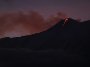
Chile , Villarica :
New explosions at Villarrica volcano linked to lava lake rise
The increased activity recorded in recent hours at Villarrica Volcano could be linked to the lava lake drawing closer to the crater’s surface, according to the Southern Andes Volcanological Observatory (OVDAS).
Early Sunday morning, the volcano again recorded explosions visible from the crater, similar to those that occurred Friday evening, ejecting columns of material reaching up to 460 meters in height. The activity remains under observation. Ian Gorayeb, director of the National Service for Risk and Disaster Prevention (SENAPRED) of La Araucanía, explained that the OVDAS report is based on recordings from surveillance cameras and acoustic sensors installed near the volcano.

“They detected increased activity associated with limited-impact explosions in the crater. Furthermore, the seismic signal did not show significant variations in amplitude. However, the report concludes that, given that this is an open-duct volcanic system with shallow lava flows, sudden explosions are not a significant factor,” he explained.
Moreover, long-period seismicity was observed during peak activity hours, suggesting increased fluid dynamics within the volcano. This confirms that Villarrica volcano continues to exhibit increased activity, possibly linked to the lava lake moving closer to the surface, a characteristic phenomenon of this volcano, which remains on green alert and under constant surveillance.
Source : Biobiochile.
Photo : Marcela P Elgueda ( archive).
Ecuador , Sangay :
DAILY REPORT ON THE STATE OF SANGAY VOLCANO, Sunday, June 7, 2026.
Geophysical Information Institute – EPN.
Surface Activity Level: High, Surface Trend: No Change
Internal Activity Level: Moderate, Internal Trend: No Change
Seismicity: From June 6, 2026, 11:00 AM to June 7, 2026, 11:00 AM:
Seismicity:
Explosion (EXP): 187
Rain/Lahars:
Precipitation has been recorded in the volcano area, but it has not triggered mudflows or debris flows. Heavy rainfall could remobilize accumulated material, generating mudflows and debris flows that could cascade down the volcano’s flanks and into nearby rivers.
Emission Column/Ash:
Due to adverse weather conditions, no gas or ash emissions were observed via the monitoring camera system or satellite imagery. Similarly, the Washington VAAC has not reported any ash clouds associated with this volcano.
Other Monitoring Parameters:
The MIROVA-VIIRS 375 satellite system recorded four thermal anomalies, and the MIROVA-VIIRS 750 satellite system recorded one in the past 24 hours.
Observation:
From yesterday afternoon until the publication of this report, the volcano remained mostly shrouded in clouds.
Alert level: Yellow
Source : IGEPN
Photo : Cristopher Cardenas / FB.