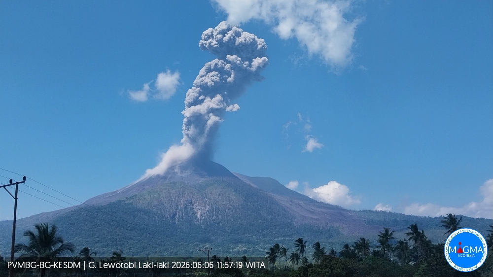
June 6 , 2026.
Indonesia , Lewotobi Laki Laki :
An eruption of Mount Lewotobi Laki-laki occurred on Saturday, June 6, 2026, at 11:55 AM WITA. The observed ash column rose approximately 2,000 meters above the summit (approximately 3,584 meters above sea level). This gray ash column was highly intense and oriented towards the west and northwest. The eruption was recorded by a seismograph, with a maximum amplitude of 29.6 mm and a duration of 113 seconds.
Seismic Observations:
Four eruption earthquakes with amplitudes ranging from 22.2 to 44.4 mm and durations from 113 to 228 seconds.
Two emission earthquakes with amplitudes ranging from 4.4 to 7.4 mm and durations from 32 to 36 seconds.
Two non-harmonic tremors with amplitudes between 5.1 and 7.4 mm and durations of 73 to 82 seconds.
Five low-frequency earthquakes with amplitudes between 5.9 and 7.4 mm and durations of 26 to 29 seconds.
VOLCANO OBSERVATORY NOTICE FOR AVIATION – VONA
Date of issue: June 6, 2026
Volcano: Lewotobi Laki-laki (264180)
Current Aviation Color Code: ORANGE
Previous Aviation Color Code: orange
Source: Lewotobi Laki-laki Volcanological Observatory
Notice Number: 2026LWK059
Geographic Coordinates: S 08° 32′ 20″ E 122° 46′ 06″
Geographic Area: East Nusa Tenggara, Indonesia
Summit Elevation: 1,584 m (5,069 ft)
Summary of Volcanic Activity:
Eruption with volcanic ash cloud at 03:55 UTC (11:55 local time).
Volcanic Cloud Altitude:
The best estimate of the ash cloud top is approximately 3,584 m (11,469 ft) above sea level, or 2,000 m (6,400 ft) above the summit. This altitude could be higher than that visible to the naked eye. Altitude data source: ground observer.
Other Volcanic Cloud Information:
The ash cloud is moving from west to northwest. The volcanic ash is observed to be gray. The volcanic ash cloud is thick.
Notes:
The eruption was recorded on the seismogram with a maximum amplitude of 29.6 mm and a maximum duration of 113 seconds.
Source et photo : PVMBG
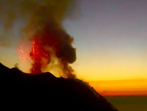
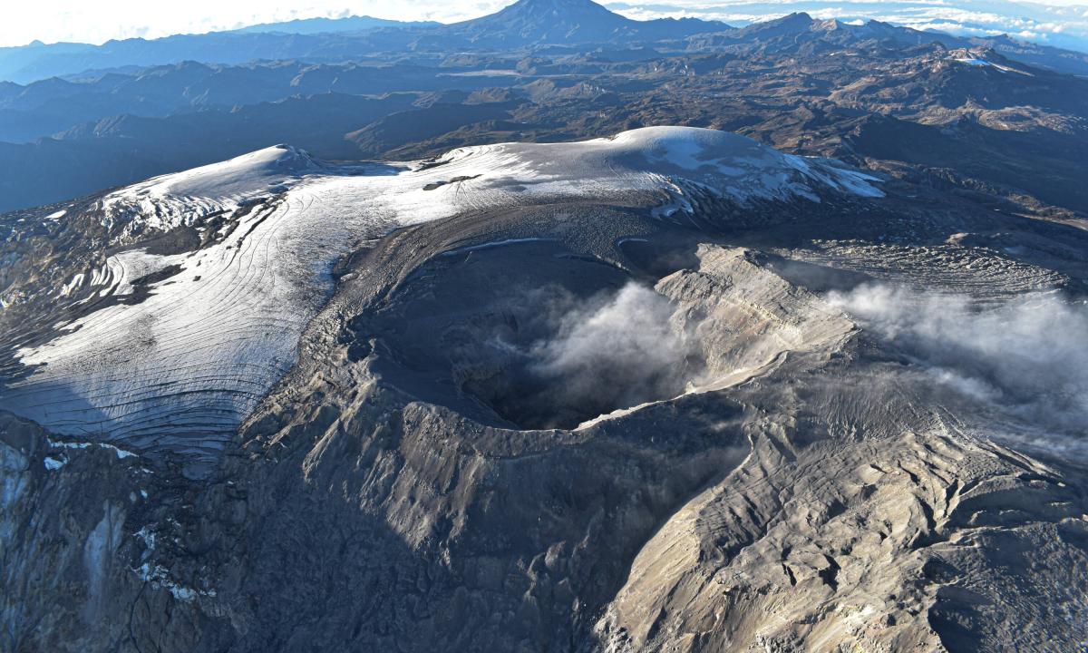
Alaska , Great Sitkin :
Slow eruption of lava likely continues within the summit crater. Typical slightly elevated surface temperatures were observed throughout the week when cloud cover was not obscuring the volcano. Seismic activity remains low, with occasional small volcanic earthquakes and minor rockfalls within the crater. Web camera observations showed no evidence of activity.
The current lava eruption began in July 2021 and has filled most of the summit crater and advanced into the valleys below. There have been no explosions at Great Sitkin Volcano since an event in May 2021. The volcano is monitored using local seismic and infrasound sensors, satellite data, and web cameras, and regional infrasound and lightning networks.
Source : AVO
Photo : Loewen, Matthew / Alaska Volcano Observatory / U.S. Geological Survey.
Colombia , Nevado del Ruiz :
Manizales, June 2, 2026, 5:10 PM
Regarding the monitoring of activity at the Nevado del Ruiz volcano, the Colombian Geological Survey (SGC), an agency under the Ministry of Mines and Energy, reports the following:
During the week of May 26 to June 1, 2026, the volcano continued to exhibit unstable behavior. Compared to the previous week, the main variations in monitored parameters were as follows:
– Seismic activity associated with rock fracturing processes within the volcanic edifice increased, both in the number of recorded earthquakes and in a slight increase in the seismic energy released. The earthquakes were primarily located on the northern flank of the volcano, less than 8 km from the crater and at depths between 3 and 8 km below the reference level. Minor earthquakes were recorded in the crater and in the north-northwest, west-southwest, and south-southeast sectors of the volcano, within 5 km of the crater and at depths between 1 and 5 km. Occasionally, earthquakes occurred on other flanks of the volcano, up to 17 km away. On May 28, a surge in seismic activity was recorded, reaching the highest number of daily earthquakes of the year. These earthquakes were located approximately 5 km north of the crater, at depths between 3 and 6 km below the datum. The largest earthquake during this period occurred at 12:15 PM, with a magnitude of 1.1 and a depth of 4 km. However, the strongest magnitude of the week was recorded on May 31 and was associated with a magnitude 1.9 earthquake, recorded at 12:29, located 8 km north of the volcanic structure and at a depth of 7 km.
– Seismicity related to fluid dynamics within the volcanic conduits remained stable, both in terms of the number of recorded earthquakes and the seismic energy released. These seismic signals corresponded mainly to short-duration, low-energy events. On May 31, a long-duration seismic signal was recorded, the first since mid-March. As in the previous period, none of these seismic signals were associated with ash emissions or variations in the apparent temperature of the gas column.
– The emission of water vapor and volcanic gases, primarily sulfur dioxide (SO₂), into the atmosphere continued through the Arenas crater. The estimated SO₂ flux associated with degassing processes increased compared to the previous week, with significant degassing on May 31 reaching levels not seen since May 2015. However, the levels observed by satellite remain low.
– The height of the gas and water vapor column remained below 400 m and reached a maximum of 900 m above the volcano’s summit on May 31. The column was directed primarily toward the northwest flank and, to a lesser extent, toward the other flanks of the volcano.
– Satellite monitoring of thermal anomalies at the bottom of the Arenas crater remained limited by persistent cloud cover in the region.
Source et photo : SGC.
Hawaii , Kilauea :
HAWAIIAN VOLCANO OBSERVATORY DAILY UPDATE , U.S. Geological Survey
Friday, June 5, 2026, 9:00 AM HST (Friday, June 5, 2026, 19:00 UTC)
19°25’16 » N 155°17’13 » W,
Summit Elevation 4091 ft (1247 m)
Current Volcano Alert Level: ADVISORY
Current Aviation Color Code: YELLOW
Summary:
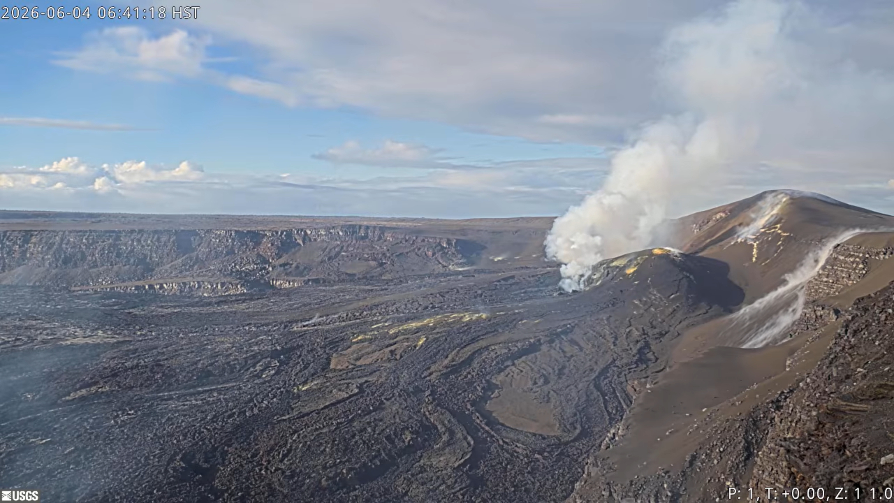
Kīlauea volcano is not erupting; the summit eruption in Halemaʻumaʻu is paused. Episode 48 occurred on June 1. Forecast models based on summit inflation rates since episode 48 indicate that episode 49 is likely to begin in 9-14 days.
Overview:
The summit eruption of Kīlauea in Halemaʻumaʻu remains paused following 9 hours of lava fountaining during episode 48 on June 1, 2026. Tiltmeters around the summit of Kīlauea have measured inflation since the end of episode 48, indicating that an episode 49 is likely; forecast models indicate that the onset of fountaining episode 49 is 9-14 days from now. Glow was visible at the vents overnight and robust degassing plumes are visibly emanating from both vents in Halemaʻumaʻu during the day.
No significant activity has been noted along Kīlauea’s East Rift Zone or Southwest Rift Zone.
Summit Observations:
Bright and continuous glow was visible from the south vent in Halemaʻumaʻu overnight, with intermittent glow visible from the north vent. Robust degassing plumes are visibly emanating from both vents in Halemaʻumaʻu during the day.
No earthquakes were detected beneath Kaluapele (Kīlauea caldera) within the past 24 hours. Low-frequency seismic pulsing continues to be recorded in Kīlauea summit region, appearing weaker over the past 24 hours compared to the previous days. This signal is typical during the pauses between eruptive episodes and may be associated with gas-pistoning.
.
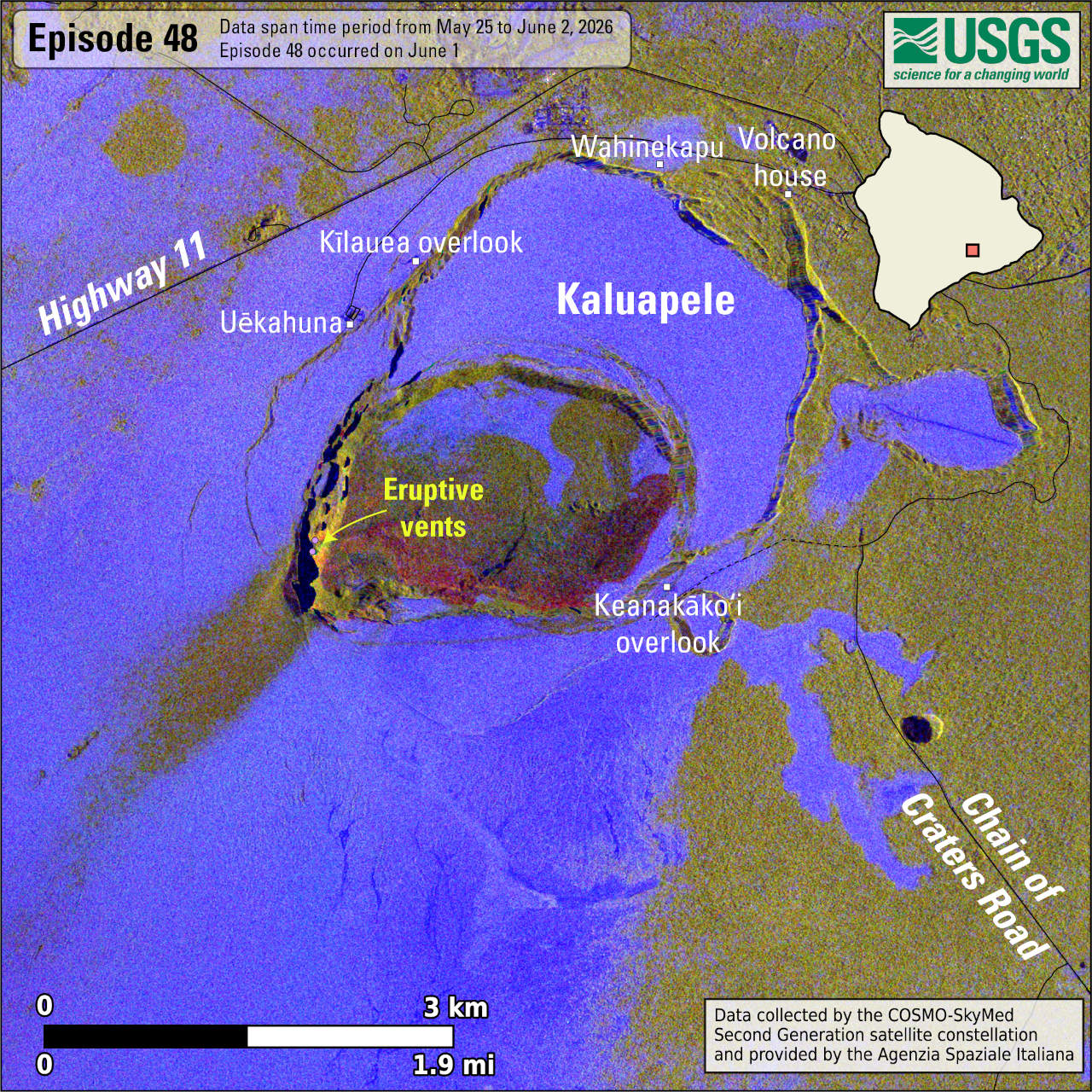
This map shows lava flow and tephra accumulation at the summit of Kīlauea volcano associated with episode 48 of the ongoing eruption in Halemaʻumaʻu that started on December 23, 2024, using data recorded by the Italian Space Agency’s (ASI) COSMO-SkyMed Second Generation satellite constellation. These maps combine cross-polarized radar amplitude images taken on two different dates (on May 25 and June 2, 2026), along with interferometric coherence from the time between those dates. In the maps, unchanged barren areas are represented in blue/purple, vegetated areas appear in yellow/light green, new deposits over barren land are shown in dark green, and the recent lava flows in red. Public viewing areas within Hawaiʻi Volcanoes National Park are indicated with white squares; these can be temporarily closed for public safety.”
The UWD tiltmeter located near Uēkahuna at Kīlauea summit recorded a total of 17.1 microradians of deflationary tilt during episode 48. Once the episode ended, inflation resumed and UWD has since recovered 7.6 microradians of inflationary tilt.
With the eruption now paused, the sulfur dioxide (SO2) emission rate from the summit is likely now varying within a typical range of 1,000 to 5,000 tonnes per day.
Rift Zone Observations:
Rates of seismicity and ground deformation remain low in the East Rift Zone and Southwest Rift Zone. SO2 emissions from the East Rift Zone remain below the detection limit.
Source et photo : USGS.
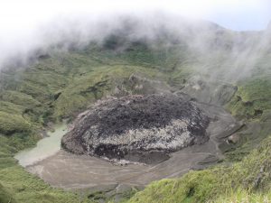
Costa Rica , Poas :
OVSICORI-UNA Volcanic Monitoring Weekly Bulletin, June 5, 2026
Latitude: 10.20°N
Longitude: 84.23°W
Altitude: 2687 m
Current Activity Level: Alert
No eruptions were recorded this week. Tremor amplitude has increased considerably in recent days, and its frequency is low. The number of long-period events has decreased. No volcano-tectonic earthquakes were recorded. The geodetic network does not indicate significant short-term deformation.
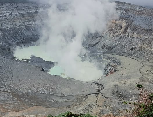
The SO₂/CO₂ ratio has decreased from approximately 2.3 last week to approximately 1.6 this week. The H₂S/SO₂ ratio remains below 0.1. This week, NOVAC stations recorded 118 ± 60 tonnes of SO₂ per day, a lower flow rate than the previous week (194 ± 74 t/d). The SENTINEL satellite detected the SO₂ plume on several occasions, peaking at 116 tonnes of SO₂ on May 29. The level of the hyperacidic lake is rising slowly.
Source : Ovsicori .
Photo : Sergio Lucena