June 4 , 2026.
Italy / Sicily , Etna :
MONTHLY BULLETIN, MAY 2026. (Publication date: June 3, 2026)
ACTIVITY SUMMARY
Based on monitoring data, the following points should be noted:
1) VOLCANOLOGICAL OBSERVATIONS: Variable degassing activity at the summit craters, with episodic and moderate emissions of volcanic ash from the Bocca Nuova crater.
2) SEISMOLOGY: No seismic activity related to fracturing (Ml ≥ 2.0); tremor amplitude remained mainly at medium levels.
3) INFRASOUND: Low-energy infrasound activity with low to medium frequency.
4) GROUND DEFORMATION: Ground deformation monitoring networks have not measured any significant long-term variations.
5) GEOCHEMISTRY: SO₂ fluxes at low to medium levels. CO₂ fluxes from the ground (Etnagas): average values.
Partial pressure of dissolved CO₂ in groundwater (Rete EtnaAcque): no update.
Helium isotope ratio at peripheral sites: high values (latest data from May 19, 2026).
6) SATELLITE OBSERVATIONS: Over the past month, thermal activity observed by satellite in the summit area has been generally low, with a few isolated moderate anomalies.
VOLCANOLOGICAL OBSERVATIONS
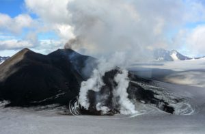
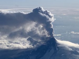
During the period under review, Etna’s volcanic activity was monitored through image analysis from the Osservatorio Etneo (INGV-OE) surveillance camera network and various field observations conducted by INGV-OE staff. Cloud cover and adverse weather conditions limited the effectiveness of remote observations on some days and, in some cases, prevented measurements due to strong high-altitude winds. Overall, during the period under review, Etna’s activity was characterized by degassing at varying rates from the summit craters, with episodic emissions of volcanic ash from the Bocca Nuova crater.
Analysis of CCTV footage and field inspections conducted by INGV-OE staff (on May 9, 12, 27, and 28) revealed degassing activity of varying intensity from almost all of the summit craters. This activity was sometimes very intense at the Northeast Crater (CNE), accompanied by intra-crater Strombolian activity, producing clearly audible detonations.
.
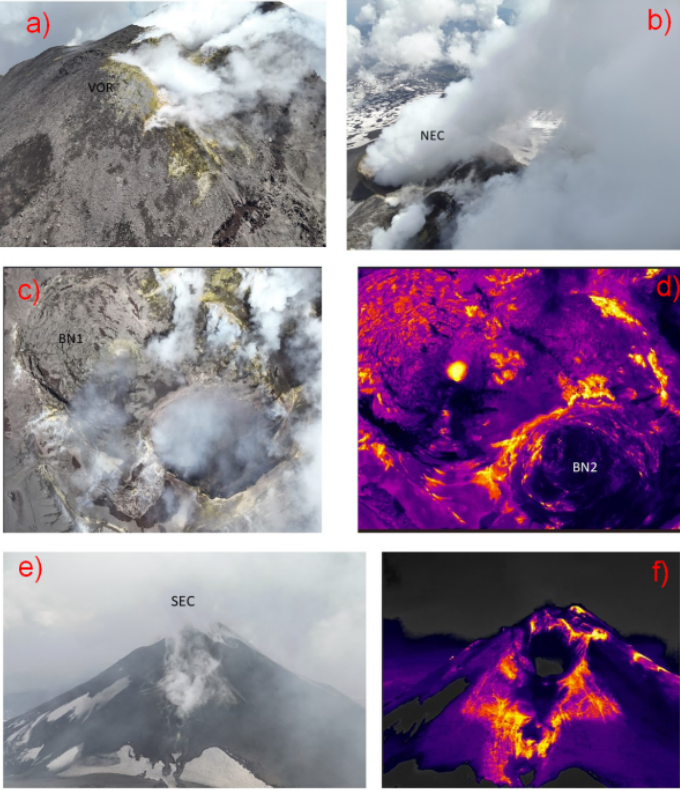
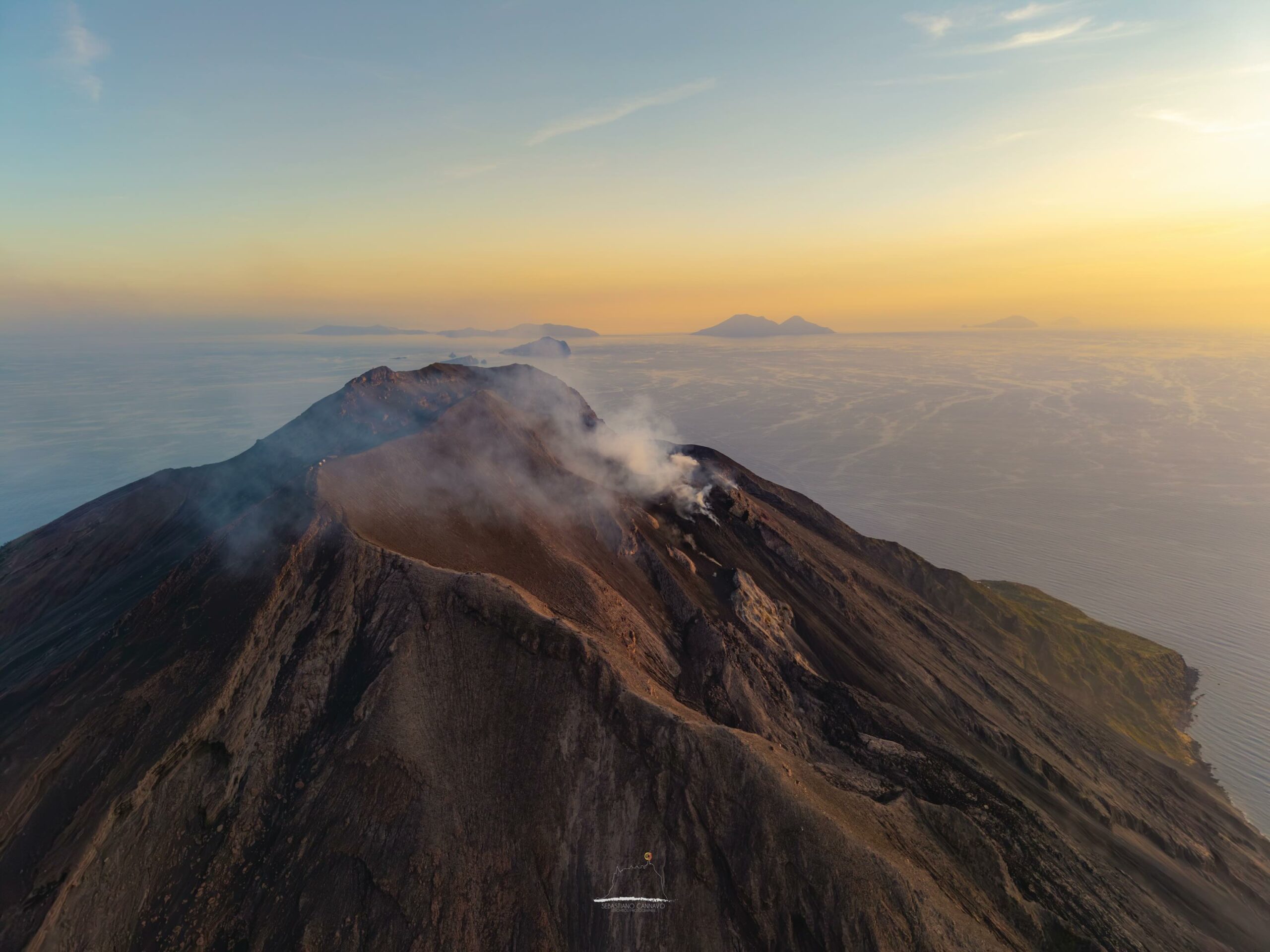
State of the summit craters during the May 28 inspection. a) Voragine Crater (VOR); b) Northeast Crater (NEC); c, d) Bocca Nuova Crater; e, f) Southeast Crater (SEC).
Bocca Nuova Crater (BN) was characterized by degassing activity of varying intensity, with sporadic and weak emissions of dilute, reddish volcanic ash from vent BN1, which were rapidly dispersed by the wind in the summit area. During the May 28 survey, a distinct thermal anomaly was detected at BN1, while vent BN2 showed no anomalies. The activity at Voragine Crater (VOR) was characterized by primarily fumarolic degassing and hot fissures, while that at Southeast Crater (SEC) was primarily fumarolic.
The vents located on the northwest flank of the Southeast CSE crater are cold, with the exception of one small cavity, as shown by the thermal survey carried out on May 28.
Source : INGV.
Photos : Gio Giusa , INGV.
Italy , Stromboli :
WEEKLY BULLETIN, May 26, 2026 to June 1, 2026. (Publication date: June 3, 2026)
ACTIVITY SUMMARY
Based on monitoring data, the following points should be noted:
1) VOLCANOLOGICAL OBSERVATIONS: Ordinary Strombolian-type eruptive activity and non-ordinary activity with effusivity due to lava overflows in the North Crater area. Lava ejections at varying rates and sometimes intense in the North Crater area. Average total hourly frequency and low intensity in the North and Central-South Crater areas.
2) SEISMOLOGY: The monitored seismic parameters show no significant variation.
3) GROUND DEFORMATION: The GNSS network did not measure any significant variations during the week.
4) GEOCHEMISTRY: SO₂ flux at an average level
CO₂ flux from the soil in the Pizzo area (STR02): No update
C/S ratio in the plume: Over the past week, it has remained in the average to high range
Helium isotope ratio (R/Ra) dissolved in the thermal aquifer: Data from the last sampling, carried out on April 29, 2026, are very high (R/Ra = 4.50).
CO₂ flux from the soil in the San Bartolo area: high to very high values.
CO₂ flux from the soil in the Scari area: average values.
5) SATELLITE OBSERVATIONS: Satellite-observed thermal activity in the summit area was generally moderate, with high values corresponding to the effusive event that began on May 26, 2026 and ended on May 28, 2026, as well as the two events of May 29 and 29-30, 2026.
VOLCANOLOGICAL OBSERVATIONS
During the observation period, Stromboli’s eruptive activity was characterized by the analysis of images recorded by the INGV-OE monitoring cameras located at an altitude of 190 m and at Punta dei Corvi (SCT-SCV and SPCT, respectively). Explosive activity was primarily produced by five eruptive vents located in the North Crater area and by at least two vents located in the Central-South area.
Observations of explosive activity captured by the monitoring cameras
Overall, total explosive eruptive activity was at moderate levels, with an isolated and moderate increase between May 25 and 26, 2026. The intensity of explosive activity remained at a moderate level in both areas. More specifically, in the North Crater area, the average explosion frequency was moderate, with explosions produced by five active vents: two in sector N1 and three in sector N2. The eruptive products were primarily composed of coarse material (bombs and lapilli). In the Central-South Crater area, two vents were observed, exhibiting explosions of fine material mixed with coarse material; the average explosion frequency was low.
Effusive Activity Due to Lava Flows (UTC)
During the week, the North Crater area also experienced three episodes of effusive activity observed by monitoring cameras. In detail:
– Episode 1. On May 26, at 7:32 a.m., lava flows began in the North Crater area, following intense ejections from active eruptive vents in sector N2. In the hours that followed, at least two lava flows were identified, their fronts remaining confined to the middle and upper-middle sectors of the Sciara del Fuoco. From noon onward, effusive activity in the proximal zone appeared to concentrate into a single lava flow. Subsequently, throughout the day and the following day, the vent’s feed gradually decreased, and effusive activity diminished slowly and progressively, ending on the morning of May 28th, around 8:00 AM, when the lava field already appeared to be cooling.
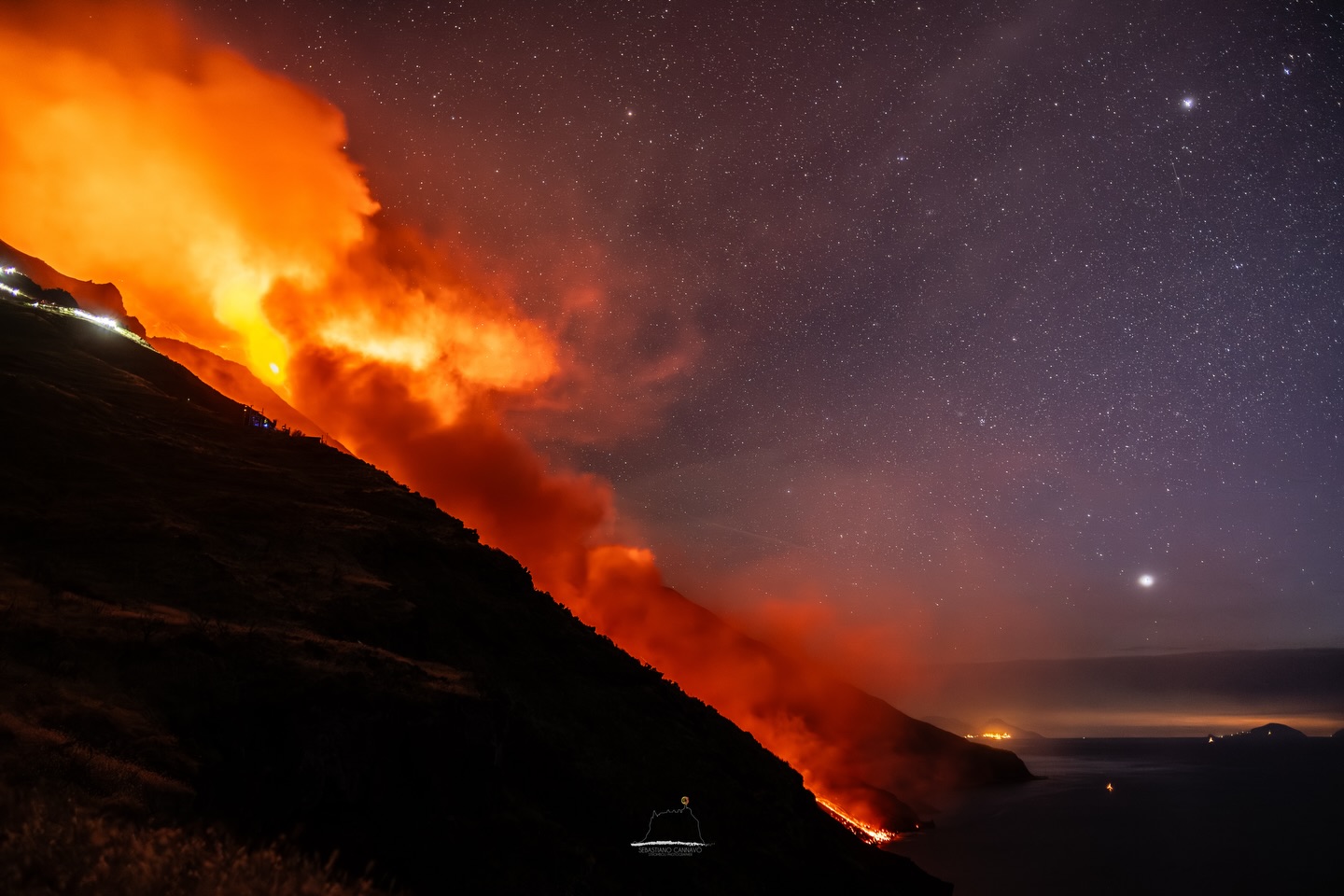
– Episode 2. Starting at 7:35 a.m. on May 29, effusive activity began due to a lava overflow fed by the active eruptive vents in sector N2. This activity produced a lava flow that deposited in the upper-middle section of the Sciara del Fuoco. This episode lasted much less time than the one on May 26; in fact, by around 11:00 a.m. that same day, the lava overflow had ceased and the lava was cooling.
– Episode 3. Starting at 9:22 p.m. on May 29, a new lava flow was observed in the upper-middle section of the Sciara del Fuoco, again fed by sector N2. By around 2:00 a.m. on May 30, the lava flow had ceased and was gradually cooling.
Source : INGV.
Photos : Stromboli stati d’animo / Sebastiano Cannavo
Indonesia , Lewotobi Laki-laki :
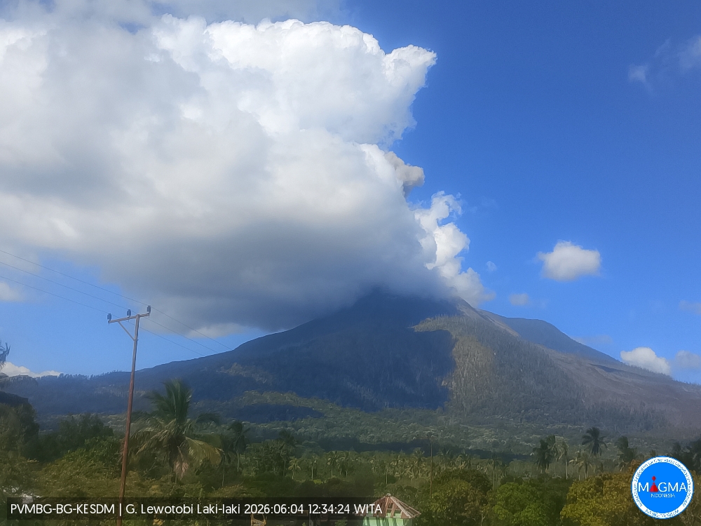
An eruption of Mount Lewotobi Laki-laki occurred on Thursday, June 4, 2026, at 10:34 AM WITA. The observed ash column rose approximately 800 meters above the summit (approximately 2,384 meters above sea level). This ash column was gray and very dense, oriented towards the southwest and west. The eruption was recorded by a seismograph with a maximum amplitude of 11 mm and a duration of 237 seconds.
VOLCANO OBSERVATORY NOTICE FOR AVIATION – VONA
Issued : June 4 , 2026
Volcano : Lewotobi Laki-laki (264180)
Current Aviation Colour Code : ORANGE
Previous Aviation Colour Code : orange
Source : Lewotobi Laki-laki Volcano Observatory
Notice Number : 2026LWK040
Volcano Location : S 08 deg 32 min 20 sec E 122 deg 46 min 06 sec
Area : East Nusa Tenggara, Indonesia
Summit Elevation : 5069 FT (1584 M)
Volcanic Activity Summary :
Eruption with volcanic ash cloud at 02h34 UTC (10h34 local).
Volcanic Cloud Height :
Best estimate of ash-cloud top is around 7629 FT (2384 M) above sea level or 2560 FT (800 M) above summit. May be higher than what can be observed clearly. Source of height data: ground observer.
Other Volcanic Cloud Information :
Ash cloud moving from southwest to west. Volcanic ash is observed to be gray. The intensity of volcanic ash is observed to be thick.
Remarks :
Eruption recorded on seismogram with maximum amplitude 11 mm and maximum duration 237 second.
Source et photo : PVMBG.
Colombia , Chiles / Cerro Negro :
San Juan de Pasto, June 2, 2026, 5:20 PM
Regarding the monitoring of activity at the Chiles-Cerro Negro Volcanic Complex (CVCCN), the Colombian Geological Survey (SGC), an agency under the Ministry of Mines and Energy, reports the following:
For the period from May 26 to June 1, 2026, the main variations in monitored parameters, compared to the previous week, were as follows:
● In a context of fluctuating seismic activity, an increase in the number of events and the energy released was recorded. Seismicity associated with rock fracturing remained predominant, followed by seismicity related to fluid dynamics.
● Most of the earthquakes occurred south of Chiles Volcano. Generally, depths fluctuated between 1.5 and 4 km from the summit of Chiles Volcano (4,700 m above sea level). During this period, two fracture earthquakes, of magnitude 2.1 and 2.4, were recorded at the aforementioned source location. The largest earthquake, of magnitude 2.9, was recorded on May 30 at 2:00 PM, with its epicenter at the summit of Chiles Volcano. Neither of these earthquakes was felt.
● Analysis of data collected by satellite sensors and ground stations continued to reveal variations related to deformation processes in the volcanic zone.
Based on the assessment and correlation of monitored parameters, the Geological Survey of Colombia (SGC) recommends closely monitoring the evolving situation by referring to weekly bulletins and other information published through its official channels, as well as instructions from local and departmental authorities and the National Disaster Risk Management Unit (UNGRD). Volcanic activity remains at the yellow alert level: active volcano with changes in the baseline behavior of monitored parameters and other manifestations.
Source et photo : SGC.
La Martinique , Mount Pelée :
Magnitude 6.3, 12.11°N, 59.05°W, depth 32 km, Saturday, May 30, 2026, 9:27 PM UTC
An earthquake (magnitude 6.3) was recorded on Saturday, May 30, 2026, at 5:27 PM (local time) and identified as being of tectonic origin. The epicenter was located 326 km southeast of Sainte-Anne, at a depth of 32 km (corresponding to a hypocentral distance of approximately 328 km). This earthquake may have generated, in the nearest affected areas, an average ground acceleration of 1.5 mg (*), corresponding to a macroseismic intensity of I-II (not felt). Depending on the soil type, the intensities may have locally reached intensity III (weakly felt).
Weekly report, Paris Institute of Earth Physics, Martinique Volcanological and Seismological Observatory. Saint-Pierre, May 29, 2026, 5:00 PM local time (GMT-4)
Between May 22, 2026, 4:00 PM UTC and May 29, 2026, 4:00 PM UTC, the Martinique Volcanological and Seismological Observatory recorded 51 volcanic earthquakes:
• 47 volcano-tectonic earthquakes. Among them, 6 had a magnitude (local magnitude Mlv or duration magnitude Md) greater than 0.5 and 4 had a magnitude greater than 1. The largest had a magnitude Mlv of 1.29. The others were of lower energy. These earthquakes originate from well-known seismically active zones on Mount Pelée, located between 1.0 and 1.4 km below the volcano’s summit. This volcano-tectonic seismicity is associated with microfracturing within the volcanic edifice, linked to the overall reactivation of the volcano observed since 2019.
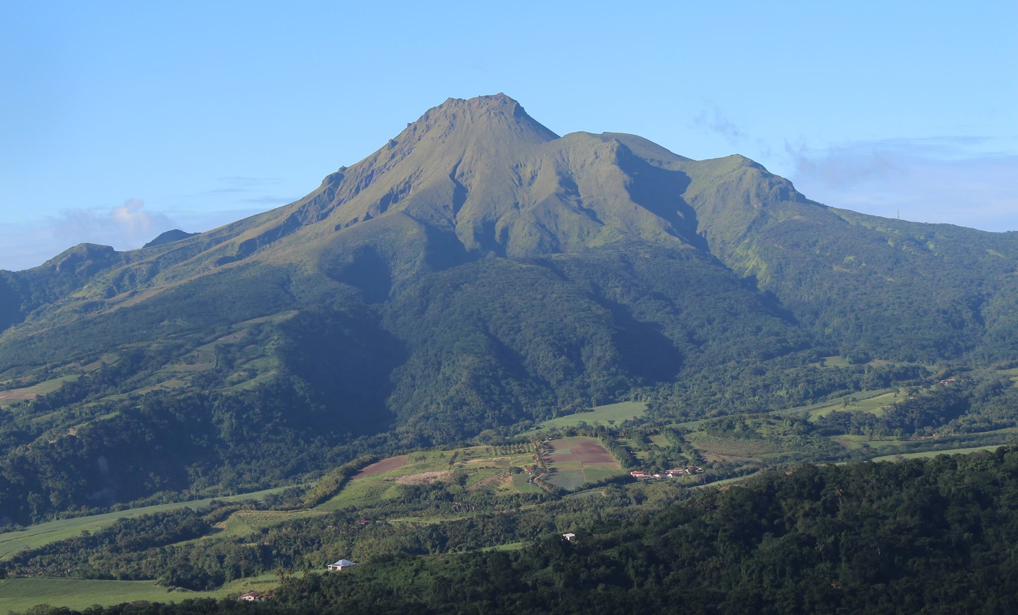
• 3 shallow, long-period earthquakes. Two of these were located in the same area as the volcano-tectonic earthquakes. The seismic signals of these types of earthquakes are enriched in (or contain only) low frequencies and are associated with the circulation of fluids (gases, hydrothermal fluids) within the volcanic edifice.
• 1 deep, long-period earthquake located at a depth of 19.7 km southwest of Mount Pelée, with a magnitude of Mlv = 0.50. Deep, long-period earthquakes are characterized by signals containing only low frequencies and are associated with the circulation of magmatic fluids deep within the Mount Pelée volcanic system. No earthquakes were felt by the population.
The previous week, the OVSM (Swiss Volcanic Observatory) had recorded 61 earthquakes of volcanic origin. As of May 29, 2026, and over the past four weeks, the OVSM (Swiss Volcanic Observatory) has observed a total of 528 volcanic earthquakes, an average of 132 earthquakes per week.
The volcanic alert level, in accordance with the measures implemented by the authorities, is currently YELLOW: vigilance.
Source et photo : Direction de l’OVSM-IPGP.