April 24 , 2026.
Hawaii , Kilauea :
HAWAIIAN VOLCANO OBSERVATORY STATUS REPORT , U.S. Geological Survey
Thursday, April 23, 2026, 11:24 AM HST (Thursday, April 23, 2026, 21:24 UTC)
19°25’16 » N 155°17’13 » W,
Summit Elevation 4091 ft (1247 m)
Current Volcano Alert Level: ADVISORY
Current Aviation Color Code: YELLOW
Activity Summary:
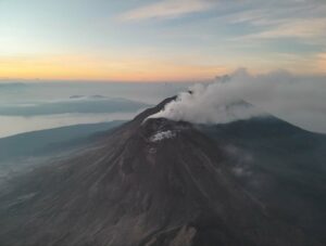
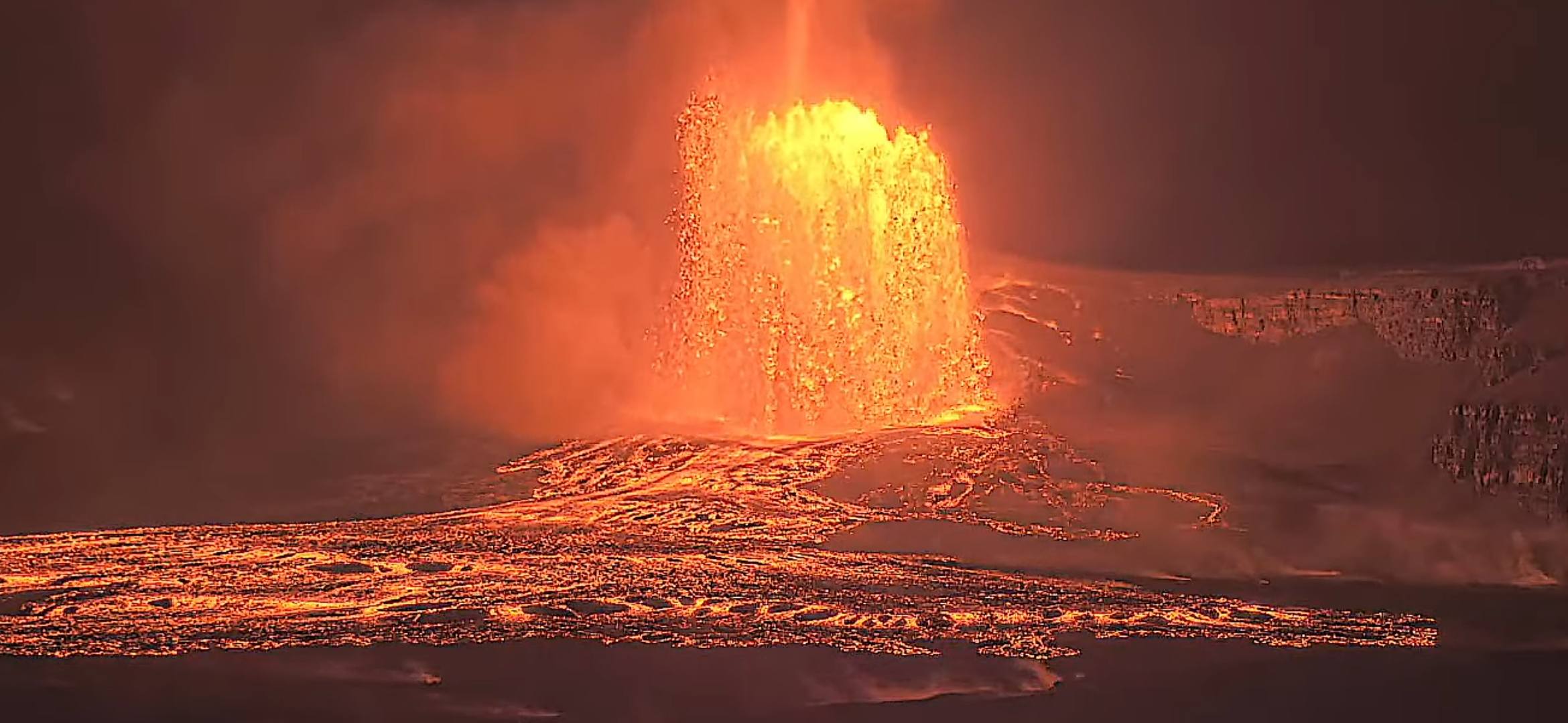
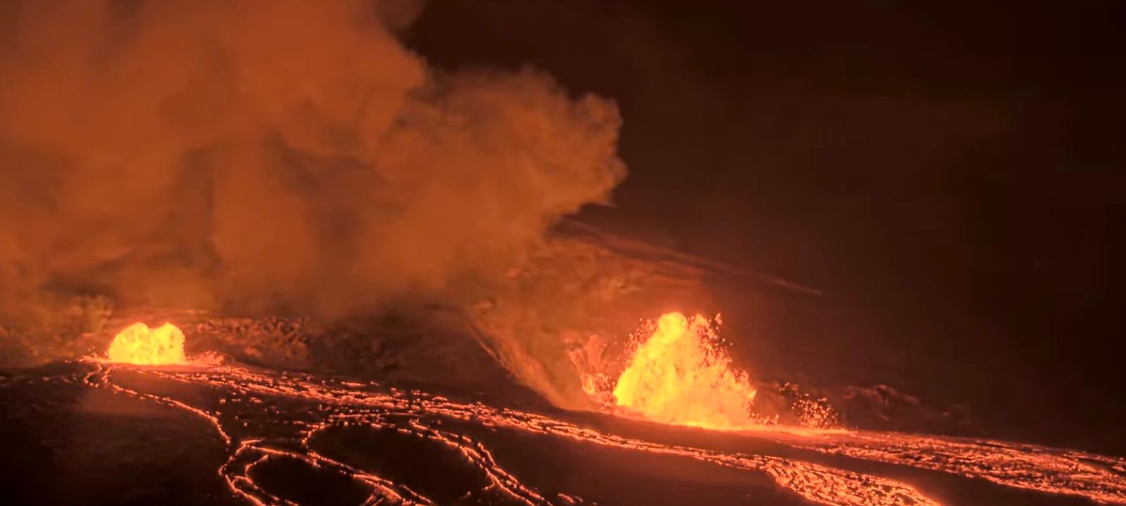
Episode 45 of the ongoing Halemaʻumaʻu eruption ended abruptly at 10:01 a.m. HST on April 23, 2026, after 8.5 hours of continuous lava fountaining. The eruption is currently paused.
No significant tephra fallout was reported at visitor areas of Hawaiʻi Volcanoes National Park or on county roads. Winds blew the plume to the south at low altitudes and to the southwest at higher altitudes, with minor amounts of ash fall reported in the community of Pāhala located about 20 miles (32 kilometers) to the southwest of the eruptive vents in Halemaʻumaʻu.
Episode 45 Chronology:
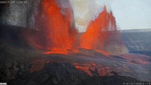
Episode 45 of lava fountaining in Halemaʻumaʻu at the summit of Kīlauea began at 1:34 a.m. on April 23 and stopped at 10.01 a.m. HST the same day, after 8.5 hours of continuous lava fountaining from the north vent. The south vent never fountained during this episode, but it displayed periodic gas jetting and flames. The highest peak of instantaneous effusion rate of just over 390 cubic yards (300 cubic meters) per second occurred around 3:00 a.m. HST on April 23. Episode 45 saw an average effusion rate of 220 cubic yards (170 cubic meters) per second, with an estimated 6.8 million cubic yards (5.2 million cubic meters) of lava erupted and covering about 50% of the Halemaʻumaʻu crater floor. The Uēkahuna tiltmeter (UWD) recorded about 16.0 microradians of deflationary tilt during episode 45.
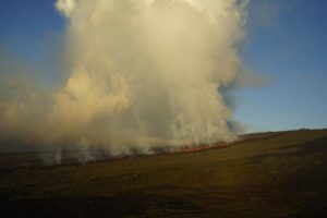
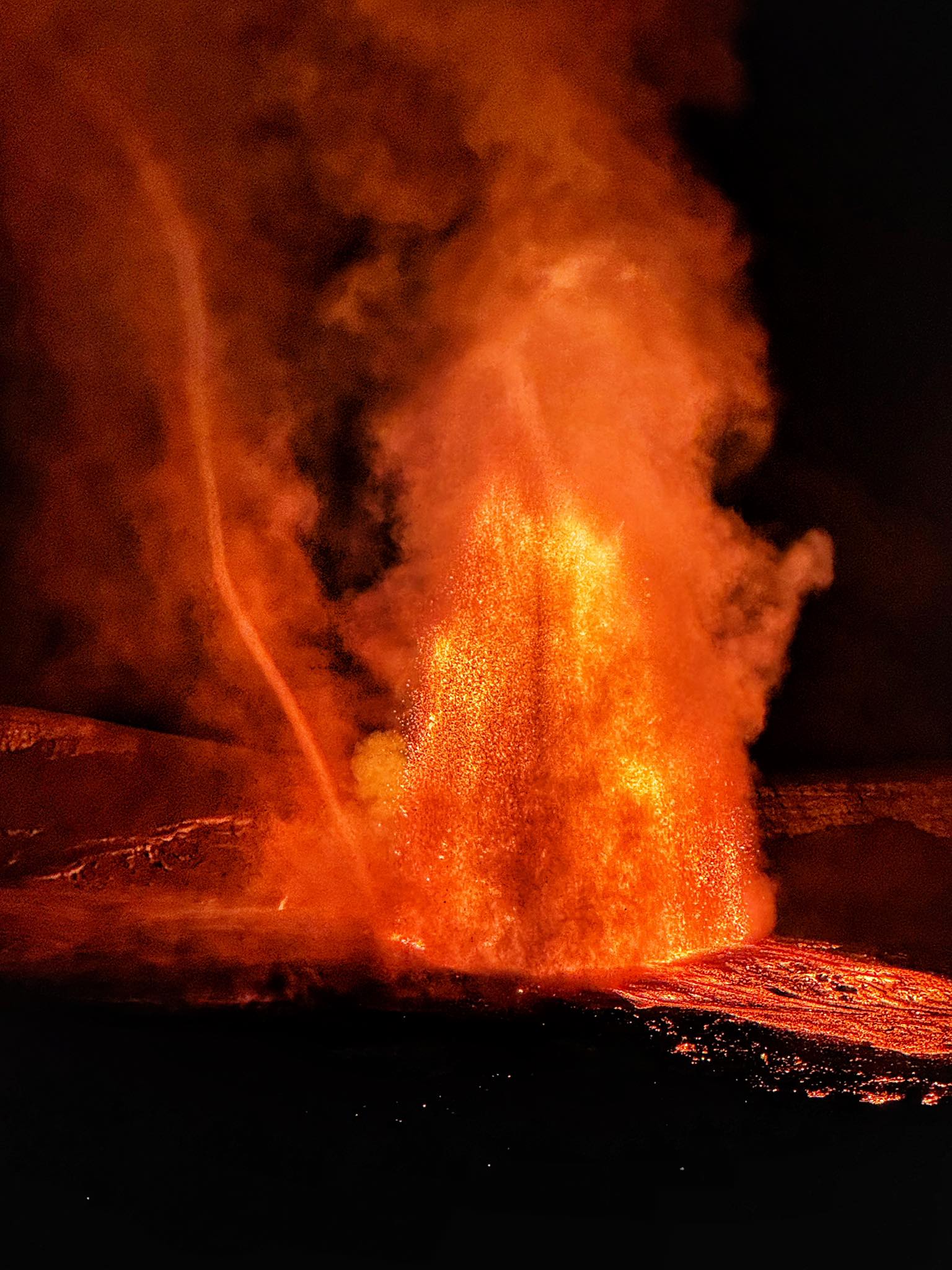
Episode 45 lava fountaining began at 1:34 a.m. HST on April 23, 2026, just over two days after the onset of precursory lava overflows on the evening of April 20. There were only 3 precursory overflows until about 9:30 p.m. when a series of overflows began from the south vent, accompanied by low dome fountaining. At 1:00 a.m. activity picked up at the north vent, with low fountaining. Over the next half hour, activity continued to increase at the north vent, while decreasing at the south vent. At 1:34, a sharp increase in seismic tremor and deflationary tilt at summit tiltmeters marked the start of the high fountaining episode. North vent fountains grew steadily until their peak at 3:00 a.m. HST. The main body of the fountains reached heights of at least 700 ft (220 meters), however wispy trails at the top of the fountain occasionally reached above 1000ft (300 meters). After their peak, fountain height gradually decreased and were about 330 feet (100 meters) high just before the episode ended abruptly at 10:01 a.m. HST.
The lava fountain produced significant heat and ash, feeding a plume that reached a maximum height of about 20,000 feet (6,000 meters) above sea level. North to northeastern winds directed the plume and tephra fall to the south and southwest of Halemaʻumaʻu. At 3:22 a.m., the National Weather Service issued an ashfall advisory for communities in the south of the Big Island that has been cancelled with the end of the episode. No significant tephra fallout was reported at visitor areas of Hawai’i Volcanoes National Park or on county roads, but some Pele’s hair and fine ash was reported falling in communities at the southern end of the island.
Earthquake activity during episode 45 was minor, and did not include a repeat of the seismicity observed at the end of episode 44. Levels of seismic tremor rose and fell with fountaining and are now at typical levels for eruption pause.
Source : HVO.
Photos : John Hentrich , USGS.
Japan , Sakurajima :
The Japan Meteorological Agency (JMA) reported ongoing eruptive activity at Minamidake Crater (Aira Caldera’s Sakurajima volcano) during 13-21 April. Crater incandescence was visible in nighttime webcam images. An explosion at 04h49 on 13 April generated an ash plume that rose around 1.2 km above the crater rim and ejected blocks as far as 1.2 km from the vent. Sulfur dioxide emissions were high, averaging 2,800 tons per day on 16 April. Explosions at 20h03 and at 23h30 on 18 April, at 01h12 on 19 April, and at 05h03 on 20 April generated ash plumes that rose 400-2,300 m above the crater rim and drifted W and SW. The explosions ejected blocks 300-1,200 m from the vent.
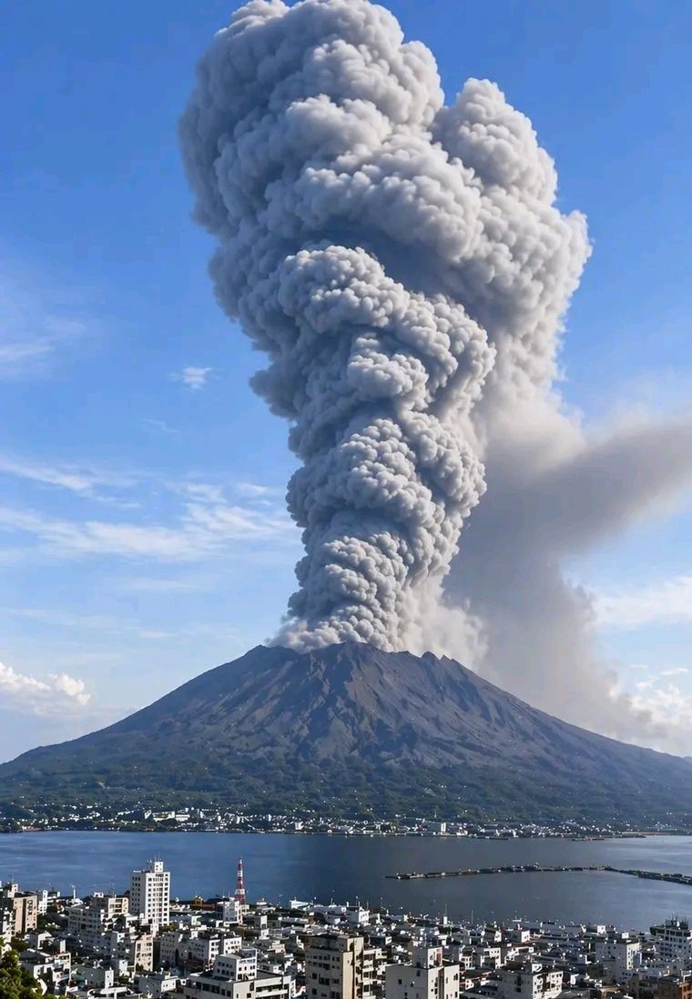
By 06h00 on 19 April minor ashfall was reported in Kagoshima City (about 10 km W), Satsumasendai City (42 km NW), Hioki City (25 km WNW), Ichikikushikino City (40 km NW), and Aira City (17 km N). Ash plumes from eruptive events at 20h18 on 18 April and at 06h22 on 20 April rose 1.4 and 1.5 km above the vent and drifted W and SW, respectively. An explosion at 15h45 on 21 April generated a moderately large ash plume that rose 2.7 km above the crater rim and drifted SE and ejected blocks 500-700 m from the vent. Ash plumes were continuously emitted, rising to 1.3 km above the crater rim and drifting S at 16h15, and decreasing to 800 m above the crater rim before ending at 17h20. An eruptive event at 22h21 generated an ash plume that rose 2.4 km above the crater rim. Moderately heavy ashfall was reported in Kagoshima City during 15h45-23h00 on 21 April. The Alert Level remained at 3 (on a 5-level scale), and the public was warned to be cautious within 2 km of both the Minimadake and Showa craters.
Sources and photo : Japan Meteorological Agency (JMA), GVP.
Chile , Lascar :
The Sistema y Servicio Nacional de Prevención y Repuesta Ante Desastres (SENAPRED) and Servicio Nacional de Geología y Minería (SERNAGEOMIN) reported decreasing activity at Láscar during 1-15 April. Seismicity decreased to baseline levels, gas plume rose to low heights, and sulfur dioxide emissions fluctuated at low or baseline levels. Low-level thermal anomalies persisted.
The Alert Level was lowered to Green (the lowest level on a four-color scale) and the public were warned to stay at least 5 km away from the crater. The Sistema y Servicio Nacional de Prevención y Repuesta Ante Desastres (SENAPRED noted that that a “Preventive Early Warning” remained in effect for San Pedro de Atacama (70 km NW). The Argentine Observatory of Volcanic Surveillance (OAVV) of the Servicio Geológico Minero Argentino (SEGEMAR) announced on 22 April that they also lowered the Alert Level to Green (the lowest level on a four-color scale).
Sources: Sistema y Servicio Nacional de Prevención y Repuesta Ante Desastres (SENAPRED), Servicio Geológico Minero Argentino (SEGEMAR) , GVP.
Photo : Sernageomin
Indonesia , Semeru :
The Pusat Vulkanologi dan Mitigasi Bencana Geologi (PVMBG) reported that activity continued at Semeru during 15-22 April, with daily eruptive events recorded by the seismic network. Daily white-to-gray and gray ash plumes were visible rising 300-1,200 m above the summit and drifting N, NE, S, and SW. An eruptive event at 0706 on 19 April generated an ash plume that rose 1 km above the summit and a news report stated that a pyroclastic flow went 4km down the Kobokan drainage on the SE flank. Another news report noted that students from Supiturang Village continued to attend class in a temporary learning space as they waited to be relocated to a different school; their school had been damaged by an eruption in January.
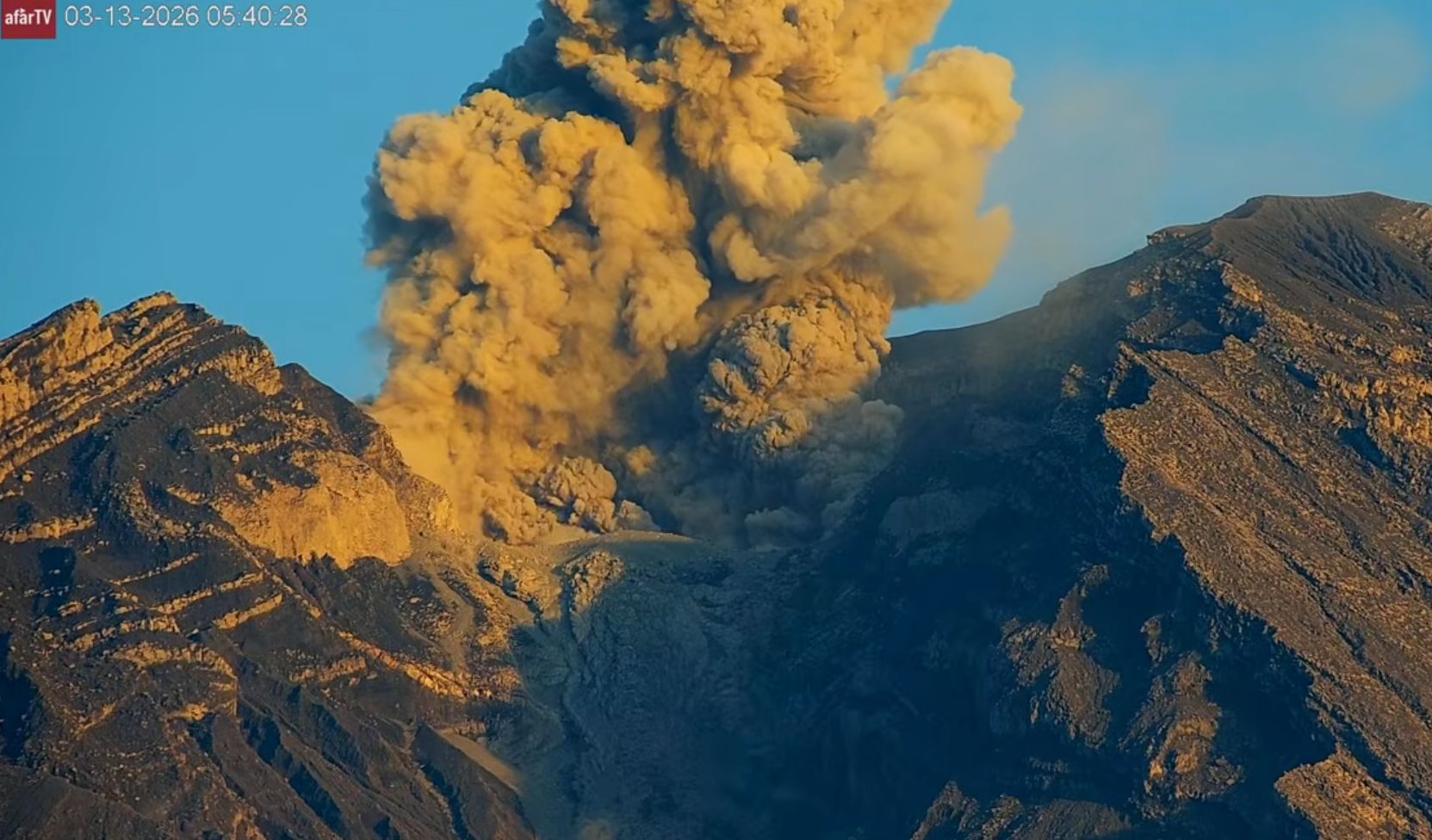
On 23 April a news article stated that the Semeru hiking trail within the Taman Nasional Bromo Tengger Semeru (Bromo Tengger Semeru National Park) was reopening the next day to allow a set number of climbers per day to descend the volcano on the main climbing route. The climbing route closed on 19 November 2025 due to eruptive activity. The Alert Level remained at 3 (the second lowest level on a scale of 1-4) and the public was warned to stay at least 5 km away from the summit in all directions, 13 km from the summit on the SE flank along the Kobokan drainage, and 500 m from the banks of the Kobokan drainage as far as 17 km SE of the summit.
Sources: Antara News, Antara News, Pusat Vulkanologi dan Mitigasi Bencana Geologi (PVMBG, also known as CVGHM), Antara News, GVP.
Photo : Afar TV. Capture d’écran .
Vanuatu Archipelago , Ambae :
On 22 April the Vanuatu Meteorology and Geohazards Department (VMGD) reported that the eruption at Ambae was ongoing. Seismic activity had decreased but continued to be characterized by continuous volcanic tremor and volcanic-seismic events. Plumes of gas, steam, and/or ash were identified in satellite images rising from the crater. At night summit incandescence was observed by residents of Ambae and nearby islands, and was visible in webcam views. The Alert Level remained at 3 (on a scale of 0-5), and the public was warned to stay outside of Danger Zone B, defined as a 3-km radius around the active vents in Lake Voui, and to stay away from drainages during heavy rains.
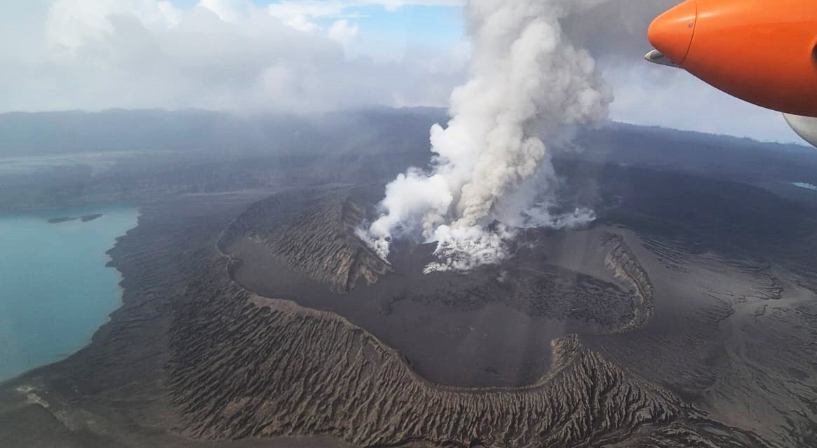
The island of Ambae, also known as Aoba, is a massive 2,500 km3 basaltic shield that is the most voluminous volcano of the New Hebrides archipelago. A pronounced NE-SW-trending rift zone with numerous scoria cones gives the 16 x 38 km island an elongated form. A broad pyroclastic cone containing three crater lakes (Manaro Ngoru, Voui, and Manaro Lakua) is located at the summit within the youngest of at least two nested calderas, the largest of which is 6 km in diameter. That large central edifice is also called Manaro Voui or Lombenben volcano. Post-caldera explosive eruptions formed the summit craters about 360 years ago. A tuff cone was constructed within Lake Voui (or Vui) about 60 years later. The latest known flank eruption, about 300 years ago, destroyed the population of the Nduindui area near the western coast.
Sources: Vanuatu Meteorology and Geohazards Department (VMGD) , GVP.
Photo : Ambassade de France / Vanuatu via Sherine France / FB.