April 10 , 2026.
Hawaii , Kilauea :
HAWAIIAN VOLCANO OBSERVATORY STATUS REPORT , U.S. Geological Survey
Thursday, April 9, 2026, 2:27 PM HST (Friday, April 10, 2026, 00:27 UTC)
19°25’16 » N 155°17’13 » W,
Summit Elevation 4091 ft (1247 m)
Current Volcano Alert Level: WARNING
Current Aviation Color Code: RED
Activity Summary:
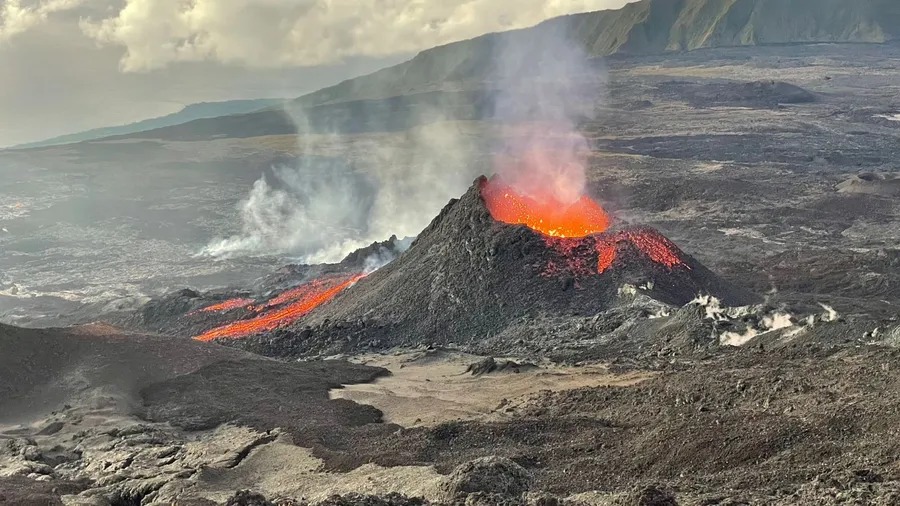
Episode 44 of the ongoing Halemaʻumaʻu eruption began at 11:10 a.m. HST on April 9 and continues at this time. Peak north vent lava fountain heights of approximately 800 feet (240 meters) were reached around 1:00 p.m. HST; fountain heights are presently about 700 feet (215 meters). The south vent has not been active so far during episode 44, though it produced significant precursory overflows that began on Friday, April 3.
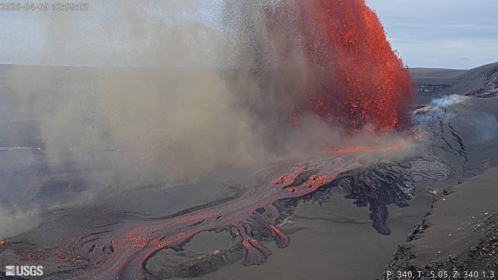
As of 2:00 p.m. HST, the north vent lava fountain is still reaching about 700 feet in height and it is feeding a plume of ash and gas above. The plume is hitting strong southerly winds about 3,000 feet (1,000 meters) above ground level, and these winds are transporting a narrow band of gas and tephra to the north-northeast of Halemaʻumaʻu. Tephra fallout is strongest in the direction of Kīlauea Military Camp and the Volcano Golf Course subdivision, with pieces of lightweight reticulite up to 12 inches (30 centimeters) reported falling in these areas. Tephra fall has also been reported near Volcano House within Hawaiʻi Volcanoes National Park.
The volcanic plume is moving northward and widening over a large section of east Hawaiʻi. These areas may expect fine ashfall consisting of Peleʻs hair and small glassy particles.
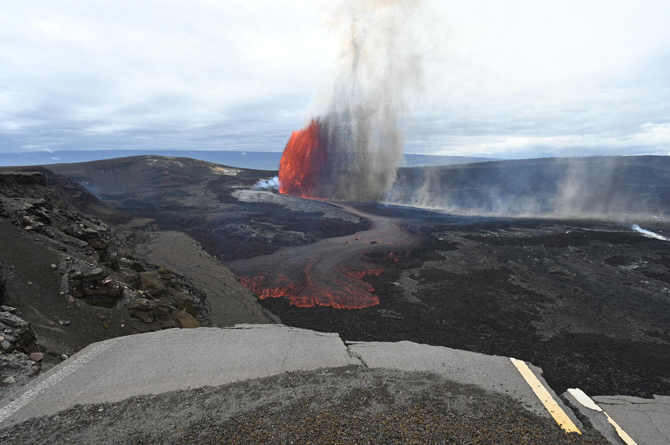
Episode 44 of lava fountaining in Halemaʻumaʻu began at the summit of Kīlauea began at 11:10 a.m. HST on April 9, 2026. Precursory lava flows began on April 3, primarily from the south vent, and continued intermittently until the episode began. The predominant lava fountain during episode 44, however, came from the north vent. This view, with a portion of Crater Rim Drive that was damaged during the 2018 collapse, was taken from the south rim of the crater.
The National Weather Service has issued an ashfall warning for much of east Hawaiʻi. The Hawaiʻi County Civil Defense Agency has closed Highway 11 through Volcano and the National Park Service has closed Hawaiʻi Volcanoes National Park due to falling tephra and sulfur dioxide (SO2) gas. Both agencies have encouraged residents to remain inside with windows closed and to disconnect water catchment tanks if possible.
Source : USGS.
Photo :USGS , USGS / L. Gallant
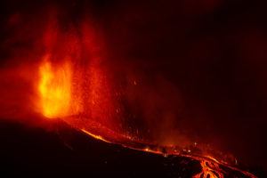
La Réunion Island , Piton de la Fournaise :
Press release from the Paris Institute of Earth Physics, Piton de la Fournaise Volcanological Observatory, April 10, 2026 – 6:30 a.m. local time – 2:30 a.m. UTC
Eruption in progress
The eruption that began on February 13, 2026, at Piton de la Fournaise continues. After two periods of inactivity (between March 25 and 28 and between April 3 and 8), eruptive activity resumed on April 8 at approximately 1:15 p.m. local time, initially within the eruptive cone formed on February 13 at an altitude of 2,056 m on the south-southeast flank of the volcano, and since April 9 (9:15 a.m. local time) at a second vent opened 230 m further upstream in an area already weakened on February 13.
It should be noted that no new dike has formed or propagated in connection with this vent. It is therefore still the same eruption, but with the opening of a new vent on the surface. As a reminder, at the beginning of the eruption, a total of four eruptive fissures opened before converging on a single point on the south-southeast flank of the volcano.
This new vent, further upstream, is currently the most active, with lava fountains whose fallout is forming a new cone. This cone is currently breached (opened), facilitating lava flows. As for the cone formed on February 13, activity there remains low, although significant degassing is still being observed.
Following the opening of this new emission point, the lava flow activity is currently located upstream of the Grandes Pentes and forms a new lava field, close to and south of the one formed between February 13 and April 3.
Tremor and Flow Rates
Following a period of intermittent tremor* observed when activity resumed on April 8 (see press release of April 9), tremor has been continuous since 12:25 local time (8:25 UTC) on April 9, and relatively stable since then, with only slight fluctuations. Surface lava flow rates estimated using satellite data (HOTVOLC, OPGC-Université Clermont Auvergne) showed maximum values of 35 m³/s during the first hours of activity at the new vent, then average values of 10 m³/s from 6:00 PM local time on April 9. Note that these values may be underestimated due to observational biases, particularly those related to weather conditions (cloud cover) and the potential development of lava tube flows, which limit the detection of thermal radiation.
Seismicity
Seismic activity is increasing very slightly but remains low, with 5 shallow volcano-tectonic earthquakes recorded in the last 24 hours.
Deformation
Following the cessation of the eruption on April 3, inflation of the volcano was recorded, indicating pressurization of the shallow magma chamber located between 1.5 and 2 km below the summit. Since the resumption of activity on April 8, this inflation appears to have ceased. This parameter will need to be confirmed in the coming days.
Alert Level 2.2
Source : OVPF / IPGP.
Photo : Reunion la 1ere.
Vanuatu Aechipelago , Ambae :
The eruption at Ambae continued during 2-9 April based on reports from the Vanuatu Meteorology and Geohazards Department (VMGD) and the Wellington Volcanic Ash Advisory Center (VAAC). VMGD noted that though residents were no longer seeing tall eruptive plumes nor hearing explosions, seismic activity remained high with continuous volcanic tremor and volcanic-seismic events. High fluxes of sulfur dioxide emissions along with a low-level thermal anomaly were identified daily in satellite data.
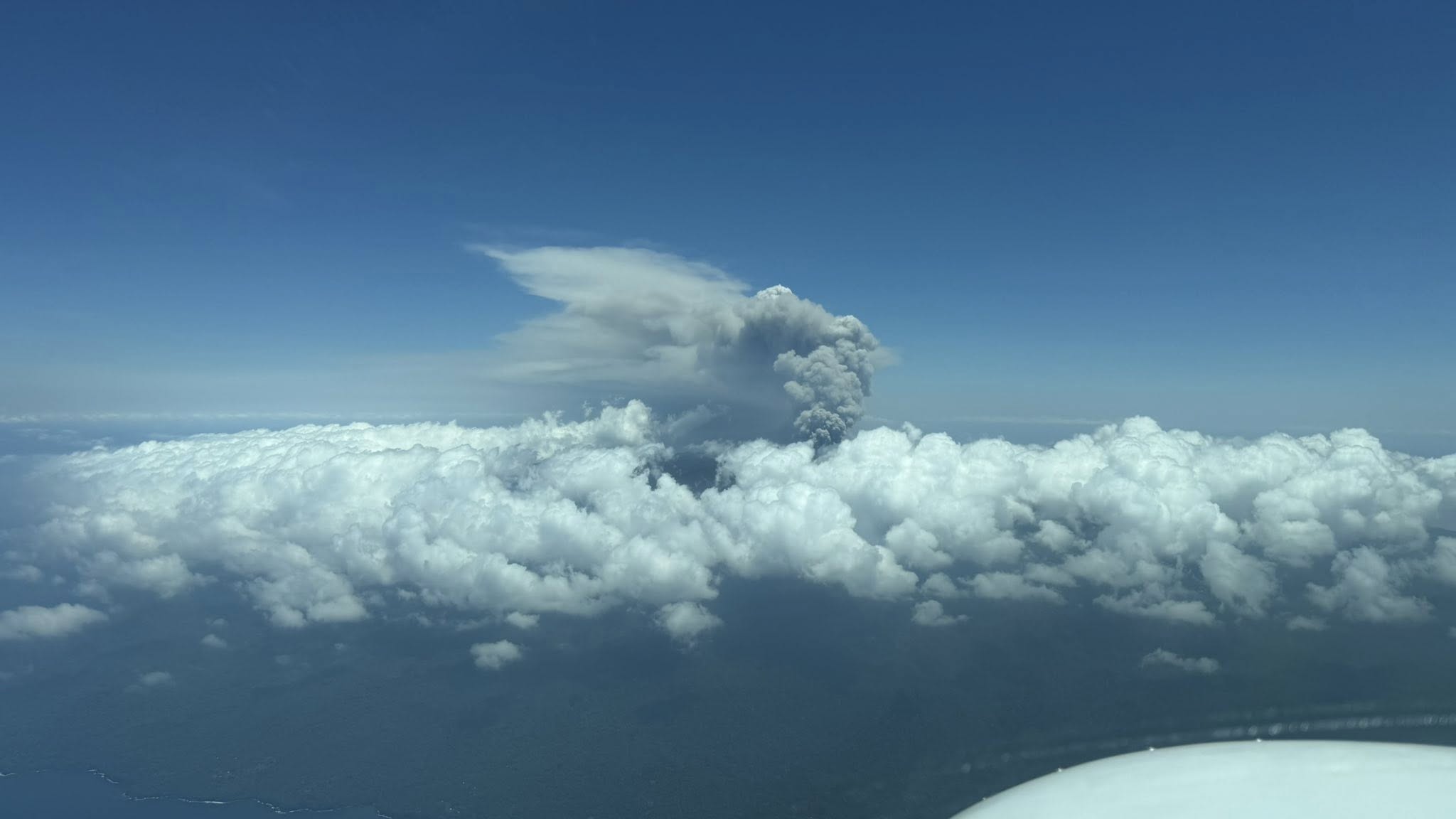
According to the VAAC low-level gas, steam, and ash plumes were visible in webcam and satellite images rising as high as 3 km (10,000 ft) a.s.l., or about 1.5 km above the summit, and drifting N during 5-6 April. Continuous low-level gas-and-steam emissions were visible in both photos and satellite images during 6-8 April. Summit glow was visible at night during 7-8 April. The Alert Level remained at 3 (on a scale of 0-5), and the public was warned to stay outside of Danger Zone B, defined as a 3-km radius around the active vents in Lake Voui, and to stay away from drainages during heavy rains.
Sources: Vanuatu Meteorology and Geohazards Department (VMGD), Wellington Volcanic Ash Advisory Center (VAAC) , GVP.
Photo : Unity Airlines Vanuatu
Philippines , Mayon :
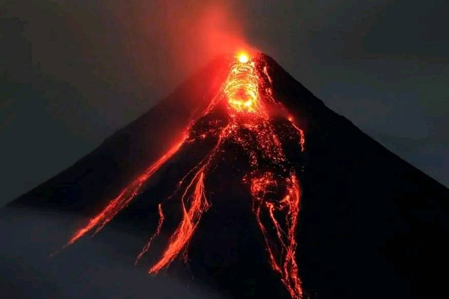
The Philippine Institute of Volcanology and Seismology (PHIVOLCS) reported that the eruption at Mayon continued during 2-8 April, characterized by lava effusion, pyroclastic density currents (PDCs), incandescent rockfalls, ash plumes, and occasional minor Strombolian activity. Emissions were visible daily, rising 400-1,000 m above the summit and drifting in different directions. Each day the seismic network recorded 217-356 rockfalls, 0-12 PDCs, and 32-159 volcanic earthquakes. There were 1-19 periods of volcanic tremor, each lasting from as short as one minute to around two and a half hours during 1-3 and 6-7 April. Daily measurements of sulfur dioxide emissions averaged 1,519-2,558 tonnes per day. The lava flows did not advance in the Mi-isi (S), Basud (E), and Bonga (SE) drainages, remaining 1.3, 3.8, and 3.2 km long, respectively. Minor Strombolian activity and short periods of lava fountaining were recorded daily. At around 2000 on 2 April a rockfall ignited vegetation on the lower S flank. The fire burned through the night but ceased by the next morning. A video posted on social media showed an ash plume rising from an area low on the E flank, possibly from a collapse at a lava flow.
The number of evacuees did not notably change; by 1800 on 7 April a total of 4,020 people (1,105 families) were staying in 12 evacuation shelters, and an additional 85 people (26 families) were staying with friends or relatives, according to the Disaster Response Operations Monitoring and Information Center (DROMIC). The Alert Level remained at 3 (on a 0-5 scale) and residents were reminded to stay away from the 6-km-radius Permanent Danger Zone (PDZ). PHIVOLCS recommended that civil aviation authorities advise pilots to avoid flying close to the summit.
Sources: Philippine Institute of Volcanology and Seismology (PHIVOLCS), Disaster Response Operations Monitoring and Information Center (DROMIC), DZGBNewsOnline, GVP.
Photo : Lan Po Lan ( archive).
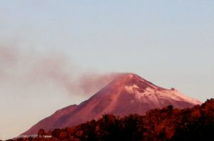
Indonesia , Ibu :
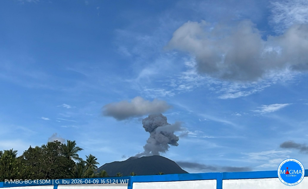
Mount Ibu experienced an eruption on Thursday, April 9, 2026 at 4:47 PM (local time). An ash column was observed approximately 700 meters above the summit (at an altitude of about 2,025 meters). This column was white to gray in color and of moderate to strong intensity, directed towards the southeast. At the time of writing, the eruption was still ongoing.
Seismicity Observations
111 eruption earthquakes with amplitudes between 15 and 28 mm and durations of 33 to 70 seconds.
1 emission earthquake with an amplitude of 10 mm and a duration of 30 seconds.
56 harmonic tremors with amplitudes between 2 and 28 mm and durations of 31 to 200 seconds.
115 low-frequency earthquakes with amplitudes between 2 and 20 mm and durations of 17 to 29 seconds.
171 shallow volcanic earthquakes with amplitudes between 2 and 8 mm and durations of 7 to 21 seconds.
1 local tectonic earthquake with an amplitude of 6 mm and a duration of 70 seconds.
98 tectonic earthquakes occurred, with amplitudes ranging from 2 to 28 mm and durations of 58 to 90 seconds.
Recommendations
1. Residents living around Mount Ibu and visitors/tourists are advised to refrain from all activities within a 2 km radius and a 3.5 km sector extension towards the crater opening in the northern part of the active Mount Ibu crater.
2. In the event of ashfall, people engaging in outdoor activities are advised to wear a mask covering their nose, mouth, and eyes, as well as protective eyewear.
Source et photo : PVMBG.