April 9 , 2026.
La Réunion Island , Piton de la Fournaise :
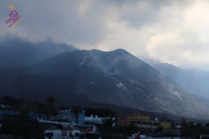
Press release from the Paris Institute of Earth Physics / Piton de la Fournaise Volcanological Observatory, April 8, 2026 – 2:25 p.m. local time – 10:25 a.m. UTC
Resumption of the eruption
Following the resumption of tremor on April 3 at 8:40 p.m. local time (16:40 UTC), a significant increase in its amplitude has been observed since this morning around 5:30 a.m. local time (1:30 UTC). This development reflects an intensification of magmatic circulation and degassing at shallow depths.
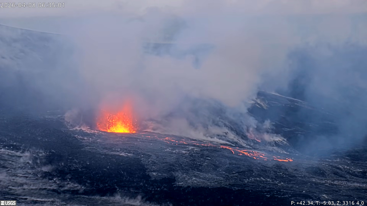
At the time of writing this press release, the tremor amplitude has reached a level higher than that observed on April 2, before the previous cessation of the eruption. In parallel, a significant increase in degassing activity has been observed at the eruptive cone of the February 13 eruption since 13:15 HL (9:15 UTC), suggesting the arrival of magma at the surface.
An overflight conducted by the SAG in the early afternoon confirmed the arrival of magma at the surface. Observations show the presence of a small lava lake inside the eruptive cone formed during the eruption of February 13, 2026, on the east-southeast flank of Piton de la Fournaise.
Since this renewed activity concerns the same eruptive cone and is not accompanied by signs of a new magma injection, it is interpreted as the third eruptive episode of the eruption that began on February 13, 2026. The first episode occurred from February 13 (10:00 AM CET) to March 25 (4:30 PM CET), the second from March 28 (3:00 PM CET) to April 3 (12:10 AM CET), and the third began on April 8 (1:15 PM CET).
Since 9:05 a.m. local time (5:05 UTC), a new vent has been observed upstream of the eruptive cone. This new vent is associated with small lava fountains and has marked the end of intermittent activity at the eruptive cone, where a lava lake remains. The opening of a new fissure near the main vent has been observed in the past, notably during the eruption of February-March 2019. A new lava flow arm has reached the steep slopes south of the previous flows, and its front is currently located at an altitude of approximately 700 m. The location of the flow front will be refined this morning by a team from the local volcanological observatory. Flow rate estimates from satellite data (HOTVOLC, OPGC-Université Clermont Auvergne and MIROVA, University of Turin) indicate peak activity of 18 m³/s. Note that these values may be underestimated due to observational biases, particularly those related to weather conditions (cloud cover) and lava flow in lava tubes, which limit the thermal radiation measured by satellite.
Source et photo : OVPF-IPGP
Hawaii , Kilauea :
HAWAIIAN VOLCANO OBSERVATORY DAILY UPDATE, U.S. Geological Survey
Wednesday, April 8, 2026, 8:21 AM HST (Wednesday, April 8, 2026, 18:21 UTC)
19°25’16 » N 155°17’13 » W,
Summit Elevation 4091 ft (1247 m)
Current Volcano Alert Level: WATCH
Current Aviation Color Code: ORANGE
Activity Summary:
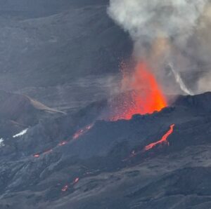
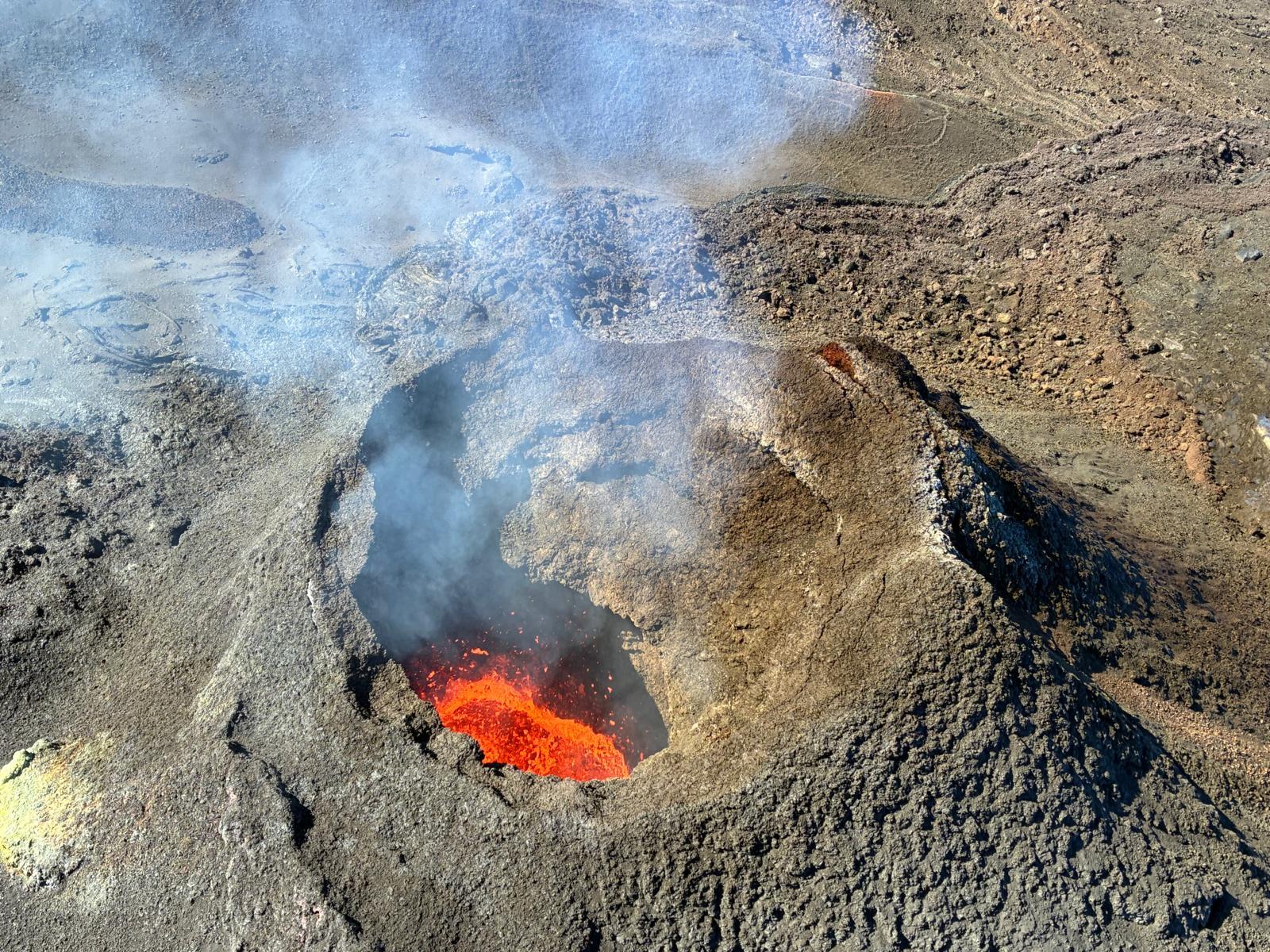
Kīlauea summit inflation returned yesterday afternoon, then south vent overflows and associated spattering resumed early this morning. Overflows and spattering may continue until lava fountaining episode 44 begins, but further periods of deflation and reduced vent activity may still occur before the next episode. The current forecast window for episode 44 is between now and April 15.
No significant activity has been noted along Kīlauea’s East Rift Zone or Southwest Rift Zone.
NOTES:
The National Weather Service (NWS) issued a Special Weather Statement yesterday about the potential for tephra fall from episode 44 in downwind communities, especially if the episode occurs in the latter half of this week, when the NWS has forecast possible south to southeasterly winds.
Summit Observations:
Heavy rain and resulting steam occluded webcam views of Halemaʻumaʻu crater for much of last night, but evidence of a fresh lava flow from the south vent became visible at 3:20 a.m. HST, and another brief overflow occurred around 6:30 a.m. HST; these were the first overflows since Monday morning, April 6. Intermittent spattering and gas jetting has also been observed at the south vent this morning, and there has been continued strong glow from the north vent.
Seismic tremor is continuous with frequent small, poorly defined bursts possibly related to the rise and fall of magma within the vents.
Following a two-day period of summit deflation starting Sunday, April 5, inflation returned to UWD tiltmeter yesterday afternoon and continues at this time. UWD has now recorded about 25.2 microradians of inflationary tilt since the end of episode 43. SMC tiltmeter has not recorded the inflation as clearly, but its data trend has likely been affected by heavy rainfall around the instrument over the past 24 hours.
During eruptive pauses like the one at present, the sulfur dioxide (SO2) emission rate from the summit has varied within a typical range of 1,000 to 5,000 tonnes of SO2 per day. Winds have been gusty out of the south and southwest since midday yesterday.
Rift Zone Observations:
Rates of seismicity and ground deformation remain low in the East Rift Zone and Southwest Rift Zone. SO2 emissions from the East Rift Zone remain below the detection limit.
Source et photo : HVO.
Indonesia , Dukono :
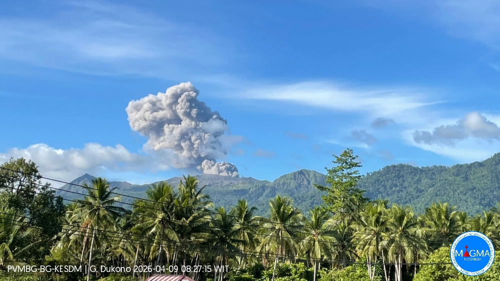
Mount Dukono experienced an eruption on Thursday, April 9, 2026 at 8:05 AM WIT. An ash column was observed approximately 1,100 meters above the summit (at an elevation of about 2,187 meters). This gray ash column, of moderate to thick intensity, was moving eastward. At the time of writing, the eruption was still ongoing.
Seismic Observations
61 eruption earthquakes with amplitudes ranging from 6 to 34 mm and durations from 34.63 to 80.9 seconds.
7 distant tectonic earthquakes with amplitudes ranging from 6 to 17 mm and durations from 61.21 to 91.45 seconds.
1 continuous seismic tremor with amplitudes ranging from 1 to 4 mm, primarily 2 mm.
Recommendations
(1) Communities living near Mount Dukono and visitors/tourists are advised to refrain from any activity, climbing, or approaching the Malupang Warirang crater within a 4 km radius.
(2) Since eruptions with volcanic ash occur periodically and the distribution of ash follows the direction and speed of the wind, making the ash cover area unstable, communities around Mount Dukono are advised to always have masks/face coverings and mouth coverings available to use as needed to avoid the dangers of volcanic ash to the respiratory system.
Source et photo : PVMBG.
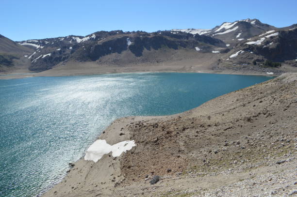
Chile , Laguna del Maule :
During the evaluated period, volcano-tectonic (VT) seismic activity, associated with rock fracturing within the volcano, maintained a similar number of events, and the energy released remained at levels comparable to those recorded during the previous period. The most energetic VT event recorded had a local magnitude (ML) of 2.9 and was located 4.9 km south-southeast (SSE) and at a depth of 7.2 km from the center of the lagoon.
Seismic activity associated with fluid movements within the volcano, represented by long-period (LP) events, recorded a similar number of events to the previous period, but with lower energy. The most energetic event, measured by its reduced displacement (DR), recorded a value of 2.8 cm².
It is also worth noting the occurrence of a hybrid seismic event (HB), associated with both rock fracturing and fluid dynamics within the volcanic system. Its energy, measured by its reduced displacement (DR), was 6.8 cm².
Radar interferometry (InSAR) applied to Sentinel-1 images shows that the uplift process continues at deformation rates similar to those of previous periods, still high relative to the reference level. Images from monitoring cameras installed near the volcanic complex revealed no surface activity. Furthermore, no thermal anomalies associated with the volcanic complex were detected through satellite image processing.
Source : Segemar.
Photo : Claudio Arriagada.
Italy , Vulcano :
MONTHLY BULLETIN, MARCH 2026, (Issuance Date: April 7, 2026)
1. SUMMARY OF ACTIVITY STATUS
Based on monitoring data, the following points should be noted:
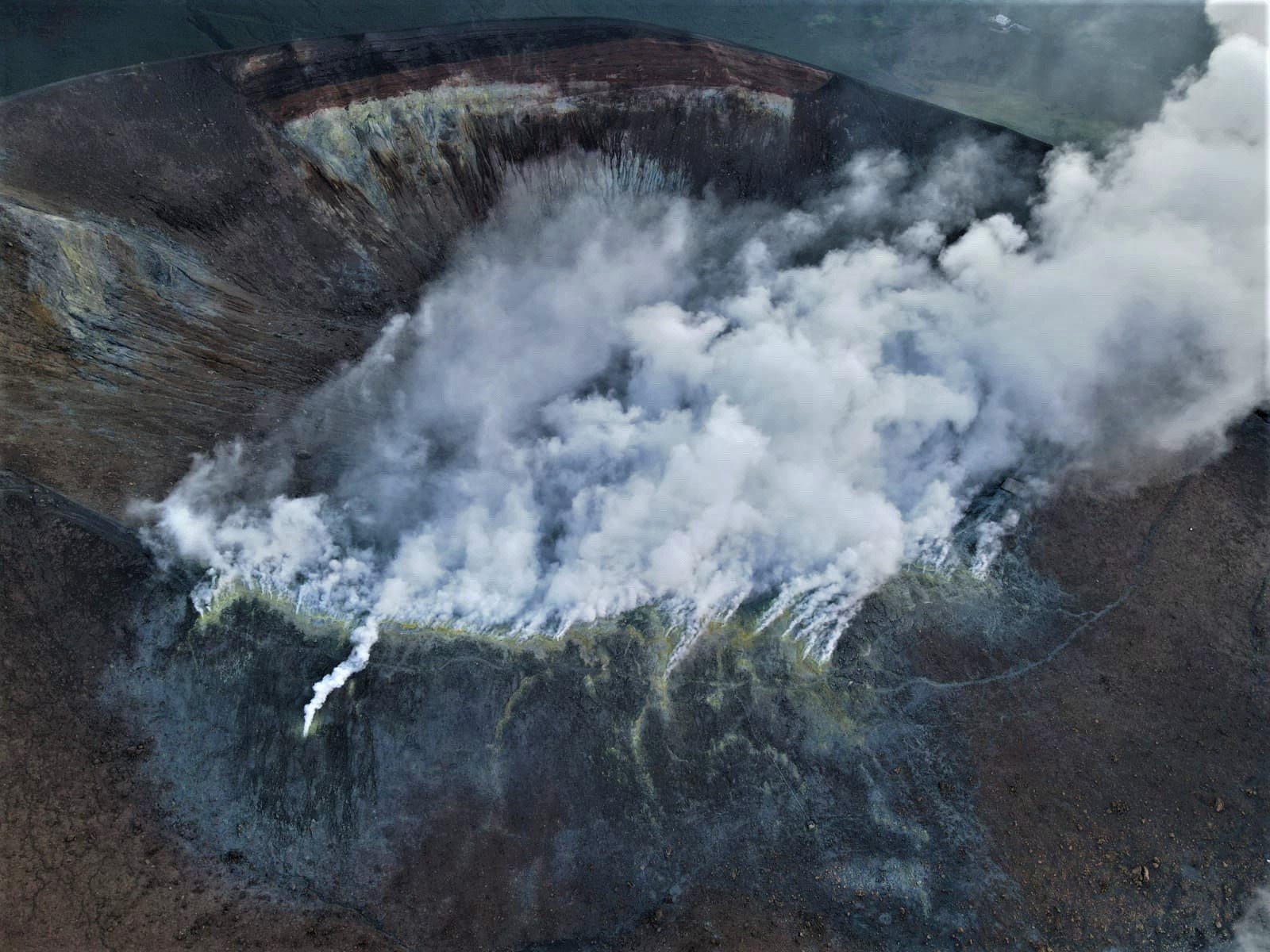
1) Crater fumarole temperature: Temperatures recorded in March are stable.
2) CO₂ flux in the crater area: The CO₂ flux in the crater area is approximately 5,000 g/m²/day.
3) SO₂ flux in the crater area: The SO₂ flux is at an average level.
4) Geochemistry of fumarolic gases: CO₂ concentrations in the fumaroles are constant.
5) CO₂ flux at the base of the La Fossa cone and in the Vulcano Porto area: Monitoring stations at the base of the cone show no significant variation compared to the previous month.
6) Geochemistry of thermal aquifers: In the Camping Sicilia and Bambara wells, the physicochemical parameters are stable.
7) Local seismicity: The occurrence rate of local microseismicity remained low.
8) Regional seismicity: Seismic activity associated with earthquakes of magnitude ML greater than or equal to 1 was very low.
9) Deformation – GNSS: No significant changes to report.
10) Deformation – Inclinometer: No significant changes to report. No data is currently available from March 31, 2026.
11) Gravimetry: No updated data is available for March due to power supply system malfunctions.
EXPECTED SCENARIOS
Dormant volcano with no eruptive activity, with gas emissions from the crater fumaroles and areas outside the crater, potentially accompanied by: the release of toxic gases into the fumarole emission zones; gas accumulations (particularly CO₂ and H₂S) near marine emission zones, in leeward areas, topographically low-lying areas, or enclosed spaces; mudflows and debris flows or flooding triggered by heavy rainfall on the slopes of the La Fossa cone.
CRATER FUMEROLE TEMPERATURES
Values recorded since March 1st show overall stabilization. The highest temperature sensor, T3, has been replaced and has displayed a stable thermal signal throughout March. The other sites have shown localized disturbances due to precipitation. Since early March, no updates have been available for the internal temperature signal (T0) due to a battery failure. The T2 sensor has also experienced a signal interruption since March 21st.
Technical intervention is underway to restore the functionality of the faulty sensors and equipment.
Source INGV
Photo : INGV-Roma1 ( archive) .