March 20 , 2026.
La Réunion Island , Piton de la Fournaise :
Press release from the Paris Institute of Earth Physics / Piton de la Fournaise Volcanological Observatory, March 20, 2026 – 11:45 a.m. local time – 7:45 a.m. UTC
Eruption in progress
The eruption that began on February 13, 2026, shortly after 10:00 a.m. (local time) at Piton de la Fournaise continues.
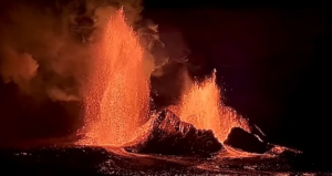
Only one eruptive site remains active on the south-southeast flank of the volcano at an altitude of 2,056 meters, with a cone that has formed from the accumulation of ejected material. Lava fountain activity has resumed at the eruptive site, with ejections reaching approximately ten meters above the cone, visible from Piton de Bert.
The lava field emitted from the eruptive site still forms two main arms. Since March 18, the North East arm has been fed again with a flow that was located at the bottom of the Grandes Pentes at an altitude of 690m, this morning at 9:10 local time.
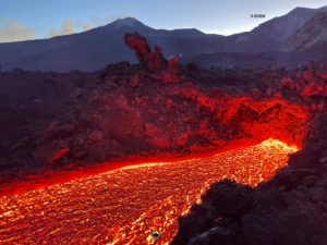
The southern arm, after splitting into several secondary branches, crossed National Route 2 (RN2) on March 13th and reached the ocean on March 16th at approximately 12:20 AM local time. Upstream of the road, several resurgences and secondary flow branches are visible, including a flow branch south of the main arm that continues its progression towards RN2.
Several secondary branches also formed downstream of RN2 before the flow reached the ocean. One of these secondary branches reached the sea between March 19th and 20th, 2026, at the southern edge of the main flow platform.
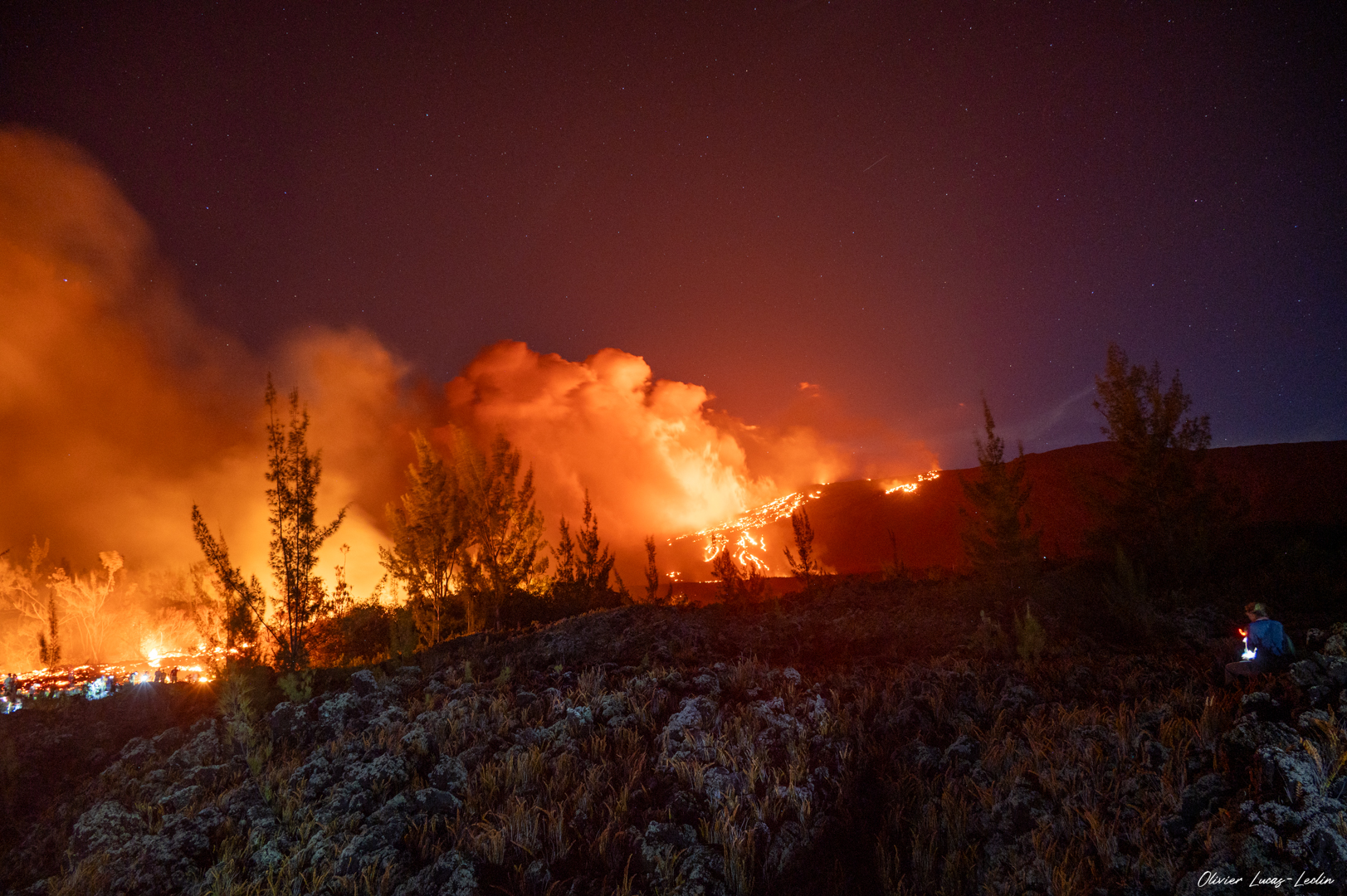
At the point of contact between the lava and the ocean, a platform continues to form and widen, resulting from the accumulation of lava flow and fine particles from lava fragmentation. Observations made by the OVPF teams on March 19 indicate that the lava platform advanced approximately 129 meters into the ocean, with a width of about 665 meters along the pre-existing coastline. This platform rises to a maximum height of about 6 meters above the ocean and represented an emerged volume of just under 200,000 m³ of lava (above sea level) on March 19. These estimates remain to be confirmed, as drone observations are sometimes obscured by the plume associated with the lava entering the sea.
A plume is still present at this point of entry into the ocean. This plume is primarily composed of water vapor, hydrochloric acid (HCl), and fine particles. When lava, at a temperature of approximately 1130°C, comes into contact with ocean water rich in sodium chloride, it generates an acidic aerosol in the form of fine suspended droplets. This plume also contains particles of pulverized lava and fragments of volcanic glass, which can be carried hundreds of meters to kilometers by the wind.
This plume, sometimes called « lava haze, » can be irritating and corrosive to the respiratory tract, skin, and eyes. Its dispersal is highly dependent on local weather conditions. Furthermore, the sudden contact between the lava and the water can generate localized explosions, projecting molten material and jets of high-temperature steam in the immediate vicinity of the point of entry into the sea.
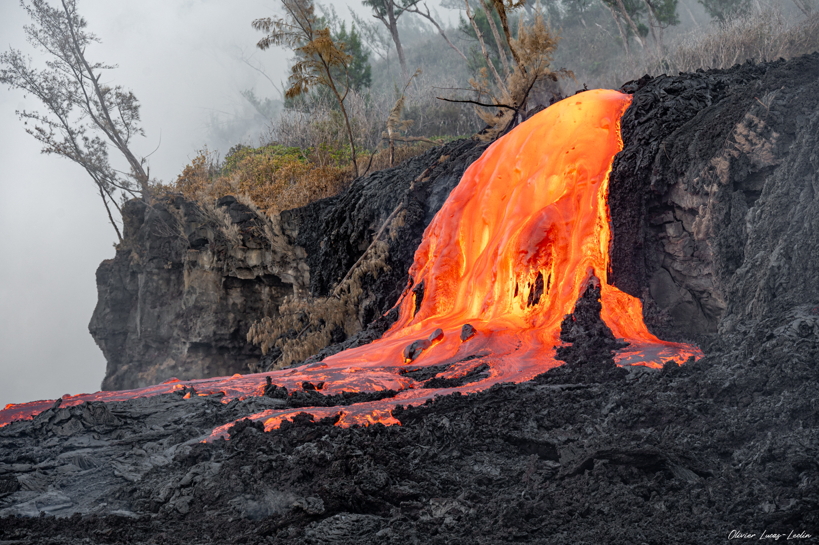
Explosions could also occur if the platform becomes destabilized. Indeed, this platform, composed of an accumulation of lava flows and rock fragments, remains highly unstable and fragile. In the event of sudden destabilization, explosions of varying intensity could occur. Furthermore, lava flows have developed within the platform. On the surface of the hardened areas, the temperature remains high, exceeding 100°C. A drone overflight conducted by the OVPF-IPGP and University of Reunion Island team on-site around 10:00 AM on March 20th indicated upwellings of hot water off the platform, suggesting the formation of submarine pillow lava flows.
The increase in seismic activity is now quite pronounced, with more than 130 volcano-tectonic earthquakes detected on March 19th. These earthquakes are located above the shallow reservoir and are of very low magnitude.
The deflation of the summit area is now clearly evident. For several days, the baselines crossing the summit showed stabilization; now, a decrease in these baselines is being recorded, indicating a contraction of the summit area. The initiation of deflation suggests a depressurization of the shallow magma reservoir.
Since March 14, a significant increase in eruptive tremor has been observed, accompanied by intermittent « gas piston » phases. These signals reflect pulsed degassing in the conduit, linked to the ascent of gas pockets through the magma approximately every 5 to 10 minutes. At the surface, this intermittent degassing manifests as alternating periods of lava fountain activity followed by calmer phases without visible ejections.
The intensification of tremor is correlated with an increase in SO₂ fluxes measured by satellite (TROPOMI) and by the OVPF’s NOVAC ground-based network since March 15, suggesting an increase in degassing activity. Since March 18, an increase in flow rates estimated using satellite data (HOTVOLC, OPGC-Université Clermont Auvergne and MIROVA, University of Turin) has also been observed, with peak values of 22 m³/s reached on March 20. It should be noted that these values may be underestimated by observational biases, particularly those related to meteorological conditions (cloud cover), the development of lava tube flows, and the entry of the lava flow into the sea, which limit the detection of thermal radiation.
Alert Level 2.2
Source : OVPF/IPGP.
Photos : Olivier Lucas- Leclin.
Japan , Meakandake :
The Japan Meteorological Agency (JMA) reported continuing eruptive activity at Akan (also known as Meakan-dake, which means Meakan Peak) of the Akan volcanic complex during 9-15 March. During a field visit on 9 March scientists measured an average of 300 tons per day of sulfur dioxide emissions, the same as the last measurement on 18 February. Weather clouds obscured webcam views for most of the week, starting during the evening of 11 March. At around 08h31 on 13 March a small-amplitude, short-duration volcanic tremor was recorded along with a very slight tilt change; eruptive activity could not be visually confirmed. Weather conditions allowed for clearer webcam views around noon on 15 March. Black deposits, likely volcanic ash, were visible on the snow near Ponmachineshiri Crater’s 96-1 vent; an eruptive event occurred sometime during 11-15 March.
The Alert Level remained at 2 (the second lowest level on a 5-level scale) and the public was warned to exercise caution within 500 m of Ponmachineshiri Crater.
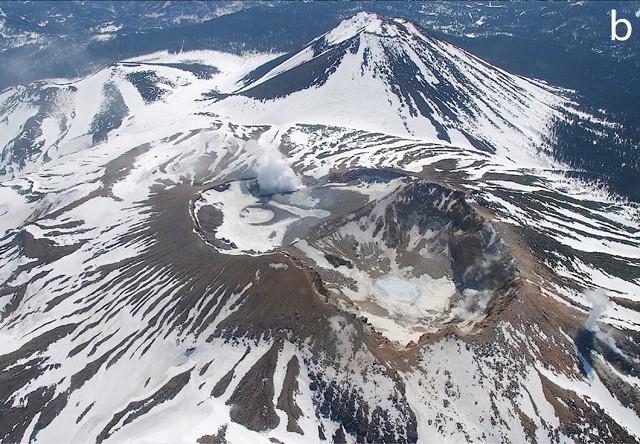
Akan is a 13 x 24 km caldera located immediately SW of Kussharo caldera in eastern Hokkaido. The elongated, irregular outline of the caldera rim reflects its incremental formation during major explosive eruptions from the early to mid-Pleistocene. There are four post-caldera stratovolcanoes, three at the SW end of the caldera and the other on the NE side. Conical Oakandake was frequently active during the Holocene. The 1-km-wide Nakamachineshiri crater of Meakandake was formed during a major pumice-and-scoria eruption about 13,500 years ago. The Meakandake group, composed of nine overlapping cones E of Lake Akan, has produced mild phreatic eruptions since the beginning of the 19th century. The main cone of Meakandake proper has a triple crater at its summit. Although recorded eruptions at Meakandake have consisted of minor phreatic explosions, four major magmatic eruptions with pyroclastic flows have also occurred during the Holocene.
Sources: Japan Meteorological Agency (JMA) , GVP.
Photo : Keiji Wada et JMA. – via GVP/ Bernard Duyck / FB.
Vanuatu Archipelago , Ambae :
The eruption at Ambae continued during 12-18 March based on reports from the Vanuatu Meteorology and Geohazards Department (VMGD) and the Wellington Volcanic Ash Advisory Center (VAAC). According to the VAAC daily gas, steam, and ash plumes were visible in webcam and satellite images rising as high as 4 km (13,000 ft) a.s.l., or about 2.5 km above the summit, and drifting W, SW, and E. The plumes had variable densities, were sometimes intermittent, and occasionally obscured by weather clouds. There was a strong sulfur dioxide signal identified in satellite images, notably during 14-15 March. During 15-16 March the plumes may have contained ash. Active lava was visible in webcam images on 16 March. On 19 March VMGD stated that seismicity remained high characterized by tremor and volcano-seismic events. The gas-and-steam emissions continued to contain variable amounts of ash during 6-19 March based on satellite and webcam images, and a thermal anomaly continued to be identified in satellite images. Incandescence at the summit was visible in webcam images on 8, 12, and 16 March.
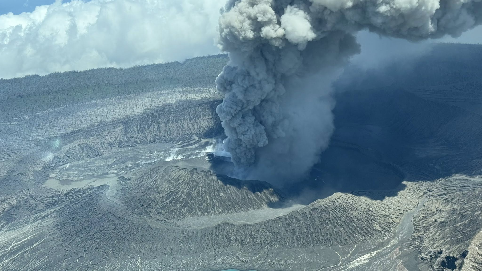
The Ministry of Health stated that as of 12 March no deaths or injuries as a result of the activity had been reported, though heavy ashfall continued to impact areas mainly to the S and W. The ashfall damaged gardens and contaminated local water sources. Health facilities reported an increase in illnesses associated with ash and gas exposure and water contamination. A total of 52 people voluntarily evacuated to other areas. The Alert Level remained at 3 (on a scale of 0-5), and the public was warned to stay outside of Danger Zone B, defined as a 3-km radius around the active vents in Lake Voui, and to stay away from drainages during heavy rains.
Sources: Vanuatu Meteorology and Geohazards Department (VMGD), Wellington Volcanic Ash Advisory Center (VAAC), Health Promotions Vanuatu, GVP.
Photo : Unity Airlines Vanuatu.
Philippines , Mayon :
The Philippine Institute of Volcanology and Seismology (PHIVOLCS) reported that the eruption at Mayon continued during 12-18 March, characterized by lava effusion and collapses at the summit dome, pyroclastic density currents (PDCs), incandescent rockfalls, ash plumes, active lava flows, and occasional minor Strombolian activity. Emissions rose as high as 800 m above the summit and drifted in various directions on most days; views were obscured during 13-14 March. The seismic network recorded 290-444 daily rockfalls and 3-8 daily PDCs. The number of daily earthquakes increased towards the end of the week with 126-287 daily volcanic earthquakes during 11-14 and 18 March, 539 volcanic earthquakes on 15 March, and 425 volcanic earthquakes on 16 March. Daily measurements of sulfur dioxide emissions averaged 1,220-2,928 tonnes per day. The lava flows did not advance in the Mi-isi (S) and Basud (E) drainages, remaining 1.3 and 3.8 km long, respectively. The lava flow in the Bonga (SE) drainage advanced 100 m during 14-15 March to reach a total length of 3.2 km. Short periods of lava fountaining were recorded during 12, 15-16, and 18 March, notably during 03h32-07h10 and 11h33-11h34 on 16 March.
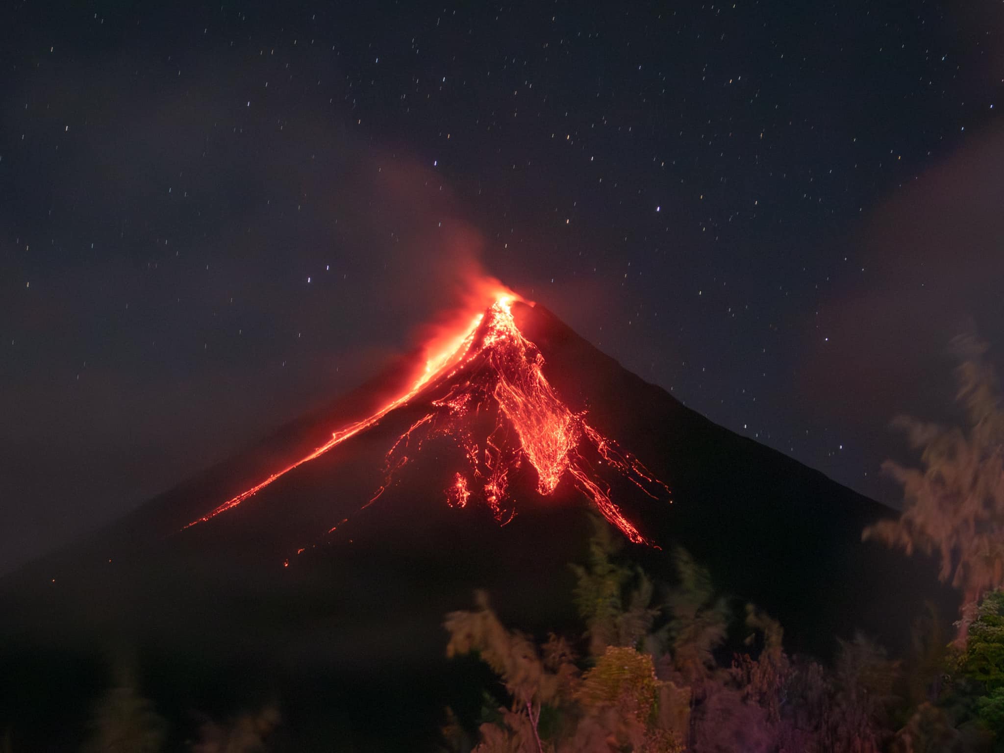
By 18h00 on 17 March a total of 4,020 people (1,105 families) were staying in 12 evacuation shelters, and an additional 86 people (27 families) were staying with friends or relatives, according to the Disaster Response Operations Monitoring and Information Center (DROMIC). The Alert Level remained at 3 (on a 0-5 scale) and residents were reminded to stay away from the 6-km-radius Permanent Danger Zone (PDZ). PHIVOLCS recommended that civil aviation authorities advise pilots to avoid flying close to the summit.
Sources: Philippine Institute of Volcanology and Seismology (PHIVOLCS), Disaster Response Operations Monitoring and Information Center (DROMIC), GVP.
Photo : Rick Estillomo
Colombia , Galeras :
San Juan de Pasto, March 17, 2026, 8:40 PM
Regarding the monitoring of activity at the Galeras volcano, the Colombian Geological Survey (SGC), an agency under the Ministry of Mines and Energy, reports the following:
For the period from March 10 to 16, 2026, the main variations in monitored parameters compared to the previous week were as follows:
● Despite low volcanic activity, a slight increase in seismic frequency and energy release was observed. Seismicity associated with rock fracturing processes within the volcanic edifice remained predominant.
● Fracture earthquakes were located near the main crater, at distances of less than 16 km, at depths between 0.3 and 8 km from the summit of the Galeras volcano (4,200 m altitude) and with a magnitude of less than 2.3.
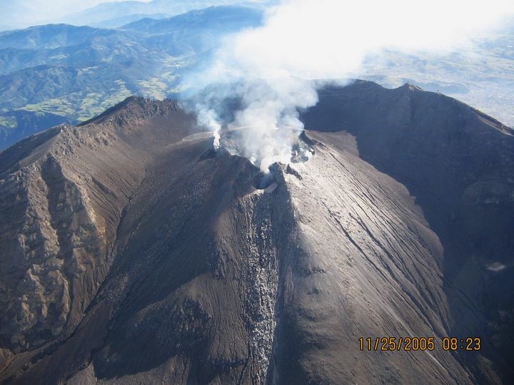
● During the week, low-altitude plumes of white gas were observed, with varying dispersion depending on wind direction, originating primarily from the fumarole fields of El Paisita in the north and Las Chavas in the west.
● Other volcanic monitoring parameters remained stable.
Geological Service of Colombia (SGC) recommends closely monitoring developments through weekly bulletins and other information published by its official channels, as well as instructions from local and departmental authorities and the National Unit for Disaster Risk Management (UNGRD).
Volcanic activity remains at the yellow alert level: Active volcano with changes in the baseline behavior of monitored parameters and other manifestations.
Source et photo : SGC.