March 9 , 2026.
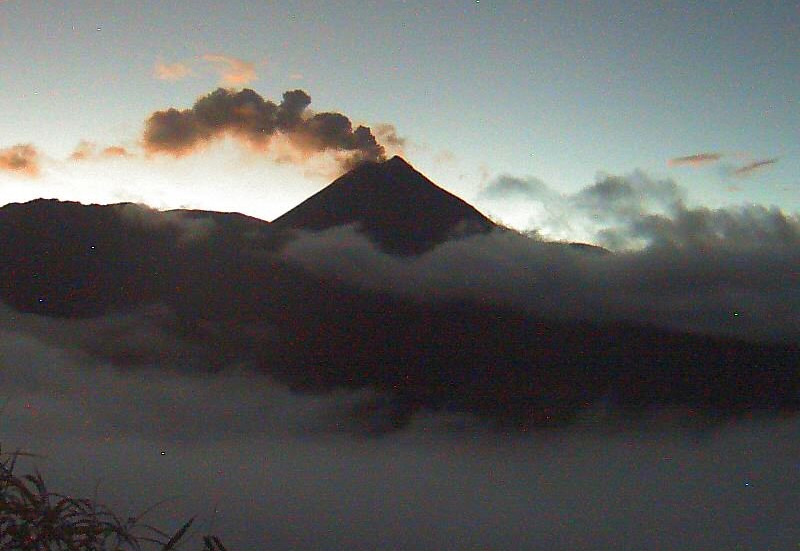
Vanuatu Archipelago , Ambae :
Vanuatu’s Ambae Island remains on high alert due to activity from the Manaro Voui volcano.
The Vanuatu Meteorology and Geo-Hazards Department said the island remains on alert level three, and a team is on the ground making assessments this morning.
Alert level four would see the entire island evacuated, with authorities urging community members to be ready to leave.
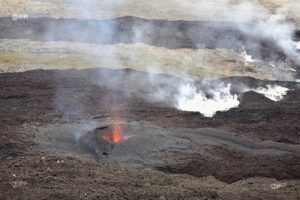
A powerful view of Ambae volcano today.
Unity Airlines conducted a special survey flight to observe the eruption and ash cloud movements from the air. The collected photos and videos have been shared with scientists and authorities to support ongoing monitoring of the volcano.
The flight was performed without passengers by our Chief Pilot to reduce any potential risk while operating near the active eruption.
The Vanuatu government last Friday decided not to order a mass evacuation of communities on Ambae Island affected by acid rain from the volcano.
The government has sent a team to assess the most affected areas and have them declared disaster zones.
Climate change minister Ralph Regenvanu said while there was no mandatory evacuation, those in the worst affected areas were encouraged to move to less affected parts of the island if they do not feel safe.
Source : RNZ.
Photo : Unity Airlines Vanuatu
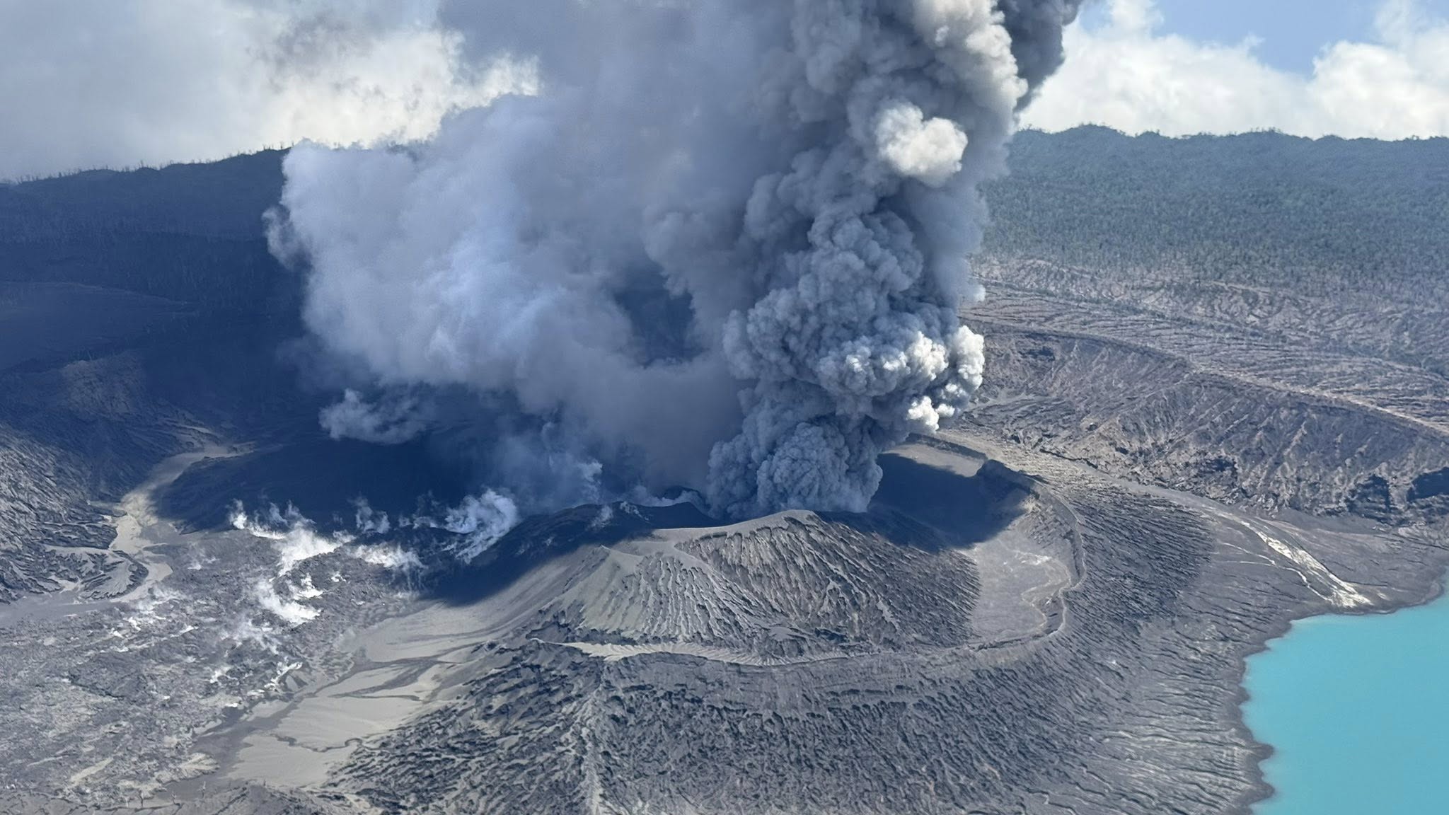
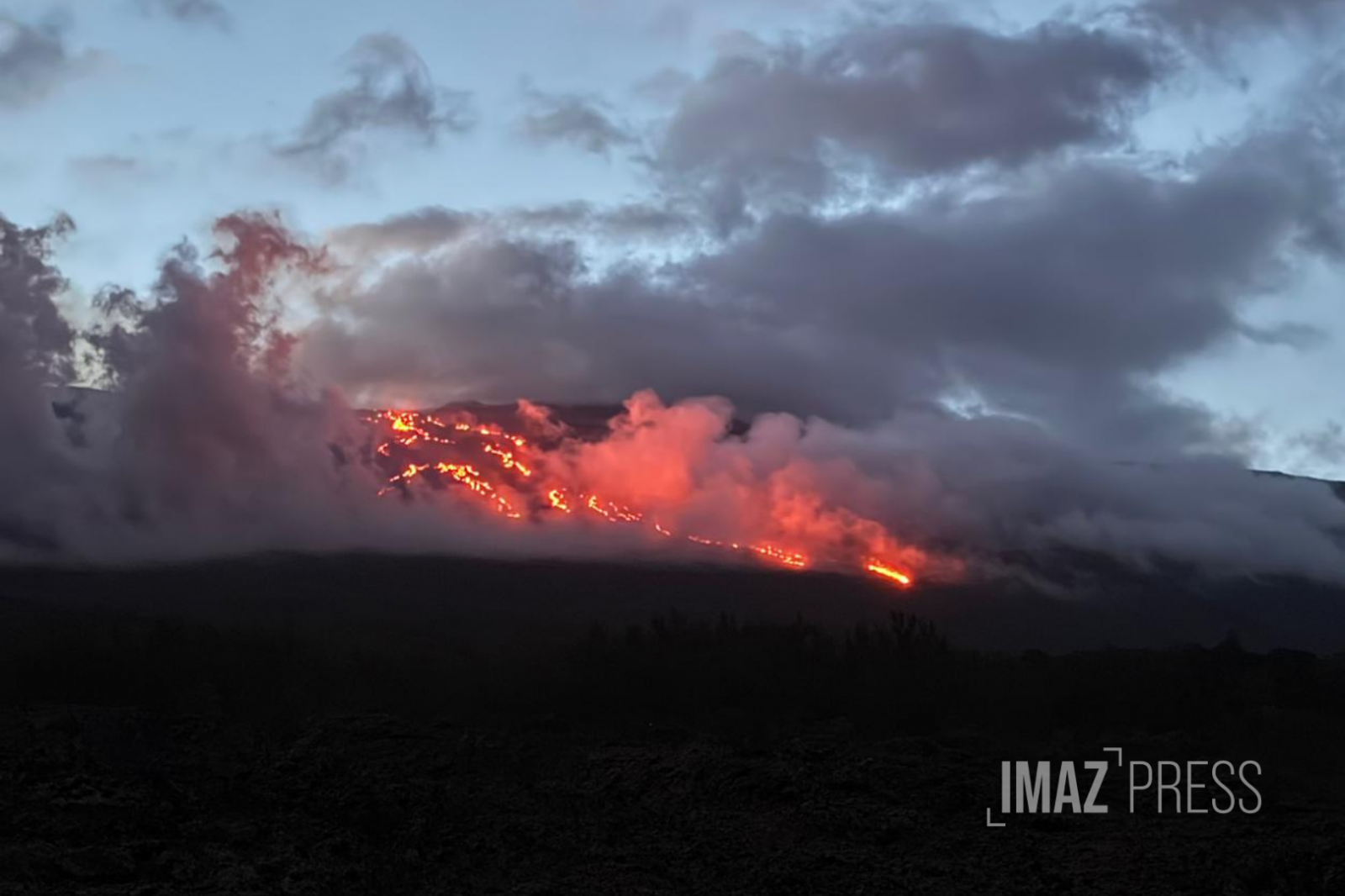
La Réunion Island , Piton de la Fournaise :
Press release from the Paris Institute of Earth Physics / Piton de la Fournaise Volcanological Observatory, March 9, 2026 – 8:30 a.m. local time – 4:30 a.m. UTC
Eruption in progress
The eruption that began on February 13, 2026, shortly after 10:00 a.m. (local time) at Piton de la Fournaise continues.
Only one eruptive site remains active on the south-southeast flank of the volcano, visible from Piton de Bert. The eruptive cone is now well-formed and continues to close progressively. Few ejecta now exceed the height of the cone.
With the lateral closure of the cone, significant lava tube activity is now established. Since March 3, lava flows have again been visible in the upper part of the Grandes Pentes, with a new flow arm.
The front of the southern arm of the lava flow, currently visible from Grand Brulé, was located on the morning of March 9th just over 2.2 km from National Route 2 and continued its slow advance. The front of the northern arm of the lava flow remains stationary at approximately 2.6 km from National Route 2, at an altitude of 660 m.
As in previous days, seismic activity remains low.
The resumption of inflation of the volcano, visible particularly on the summit GNSS stations and at the base of the terminal cone, is now well established. Indeed, since the end of February, the baselines crossing the summit have recorded an increase in distance, indicating a progressive re-expansion of the volcano.
This inflation indicates a repressurization of the magma supply system, possibly linked to magma recharge from the shallow reservoir.
Over the last 24 hours, eruptive tremor (an indicator of lava and gas emissions at the surface) has remained relatively stable. In the long term, the amplitude of the tremor shows a progressive increase since February 21. Some amplitude peaks are still being recorded, probably linked to variations in degassing or morphological changes in the eruptive cone. Surface flow rates, estimated from satellite data via the HOTVOLC platform (OPGC – Clermont Auvergne University), have indicated values between 1 and 7 m³/s over the past 24 hours. It should be noted that these estimates can vary significantly depending on cloud cover and become zero in the event of total cloud cover.
Due to adverse weather conditions on site over the past 24 hours, these flow rate estimates are underestimated.
Alert Level 2.1
Source : OVPF/IPGP.
Photo : Imaz Press.
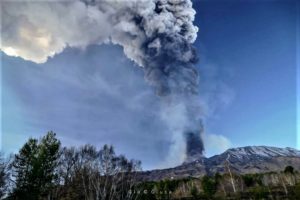
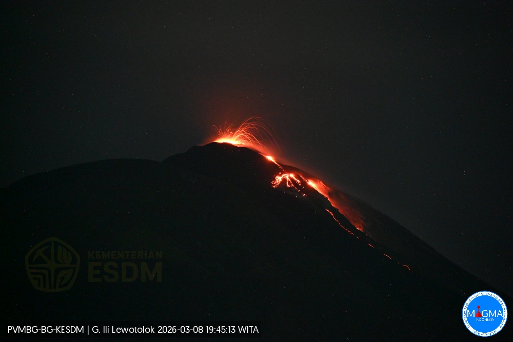
Indonesia , Ili Lewotolok :
An eruption of Mount Ili Lewotolok occurred on Sunday, March 8, 2026, at 7:44 PM WITA. The observed ash column rose approximately 100 meters above the summit (about 1,523 meters above sea level). White to gray in color, the moderately intense ash column drifted eastward. This eruption was recorded by a seismograph, with a maximum amplitude of 23.3 mm and a duration of 55 seconds.
Seismicity observations:
130 eruption earthquakes with amplitudes between 14 and 36.6 mm and durations of 35 to 63 seconds.
231 emissions earthquakes with amplitudes between 1.3 and 10.1 mm and durations of 20 to 42 seconds.
Two non-harmonic tremors with amplitudes between 2.3 and 7.4 mm and durations of 105 to 118 seconds.
Two deep volcanic earthquakes with amplitudes between 3.3 and 3.9 mm and durations of 10 to 12 seconds.
Recommendations
1. Residents living near Mount Ili Lewotolok, as well as visitors, climbers, and tourists, are advised to refrain from any activity or presence within a 2 km radius of the Mount Ili Lewotolok activity center.
2. Be aware of the potential threat of lava flows and hot clouds in the south and southeast, west and northeast sectors of Mount Ili Lewotolok.
Source et photo : Magma Indonésie .
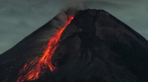
Ecuador , El Reventador :
REVENTADOR VOLCANO DAILY STATE REPORT, Sunday, March 8, 2026.
Information Geophysical Institute – EPN.
Surface Activity Level: High, Surface Trend: No Change
Internal Activity Level: Moderate, Internal Trend: No Change
From March 7, 2026, 11:00 AM to March 8, 2026, 11:00 AM:
Seismicity:
Explosions (EXP) 33
Long Periods (LP) 3
Emission Tremors (TREMI) 4
Harmonic Tremors (TRARM) 3
Rainfall/Lahars:
No rainfall has been recorded in the volcano area. **Heavy rainfall could remobilize accumulated material, generating mudflows and debris flows that would cascade down the volcano’s flanks and into nearby rivers.**
Emission Column/Ash:
Due to data transmission issues, it was not possible to observe gas and ash emissions via the monitoring camera system. However, satellite imagery detected two emissions with columns reaching heights of 700 and 800 meters above the crater rim, both drifting westward. In connection with this activity, the VAAC agency in Washington issued two reports corresponding to emissions with column heights of 700 and 1000 meters above the crater rim, both drifting westward.
Other monitoring parameters:
Over the past 24 hours, the MIROVA-VIIRS satellite system recorded a thermal anomaly.
Observation:
From yesterday afternoon until the closing of this report, satellite monitoring showed that the volcano remained mostly cloudy.
Alert level – SGR: Orange
Source et photo : IGEPN.
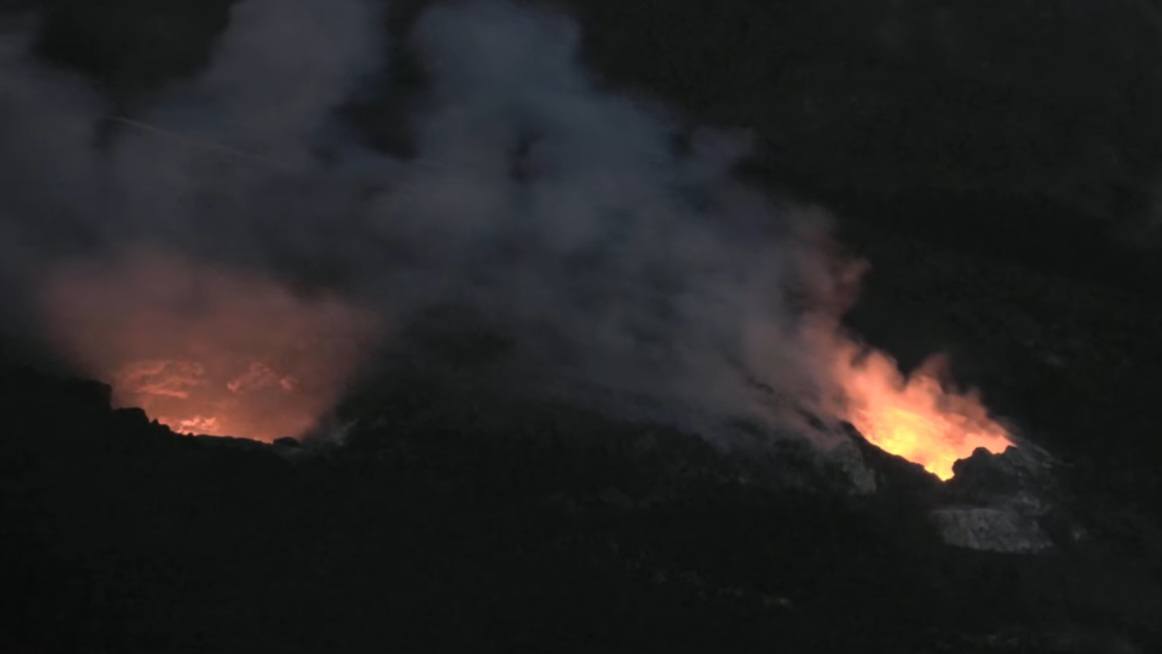
Hawaii , Kilauea :
HAWAIIAN VOLCANO OBSERVATORY DAILY UPDATE , U.S. Geological Survey
Sunday, March 8, 2026, 8:28 AM HST (Sunday, March 8, 2026, 18:28 UTC)
19°25’16 » N 155°17’13 » W,
Summit Elevation 4091 ft (1247 m)
Current Volcano Alert Level: WATCH
Current Aviation Color Code: ORANGE
Activity Summary:
The Halemaʻumaʻu eruption of Kīlauea is paused. Episode 42 ended February 15 at 11:38 p.m. HST. In the last 24 hours, continuous inflation of the summit has been observed. The modeled forecast window for the onset of episode 43 lava fountaining is March 10-14.
No significant activity has been noted along Kīlauea’s East Rift Zone or Southwest Rift Zone.
Summit Observations:
Continuous strong glow was observed at the north vent while more intermittent, weak glow was visible at the south vent in webcams overnight. Both the north and south vents also exhibited periods of minor spatter with glow at the south vent increasing in the early morning. Both vents are emitting steady gas plumes. Continuous low level seismic tremor was observed over the last 24 hours. There were six small earthquakes located in the summit region in the last 24 hours with the largest being a magnitude 1.1 this morning.
Inflation resumed yesterday around noon and has continued through this morning. As of this morning, the UWD tiltmeter has recorded 29.2 microradians of inflationary tilt since the end of episode 42, with about 1.3 microradians of net inflation over the past 24 hours.
Sulfur dioxide (SO2) emission rates from the summit have typically averaged 1000-1500 t/d during eruptive pauses. Webcams show the plume blowing southwest this morning in moderate trade winds.
Rift Zone Observations:
Rates of seismicity and ground deformation remain very low in the East Rift Zone and Southwest Rift Zone. SO2 emissions from the East Rift Zone remain below the detection limit.
Source : HVO.
Photo : Hawaii Volcanoes National Park