February 24 , 2026.
La Réunion Island , Piton de la Fournaise :
Press release from the Paris Institute of Earth Physics / Piton de la Fournaise Volcanological Observatory, February 24, 2026 – 9:45 a.m. local time – 5:45 a.m. UTC.
Eruption in progress
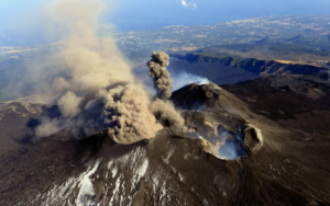
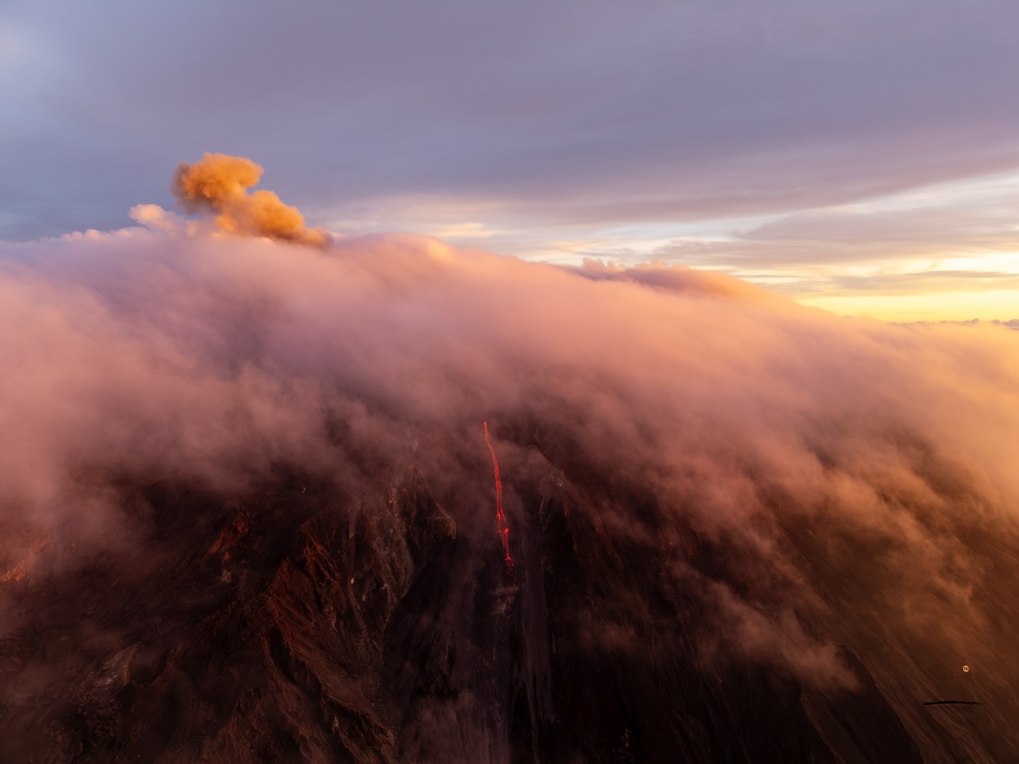
The eruption that began on February 13, 2026, shortly after 10:00 a.m. (local time), at Piton de la Fournaise continues.
Only one eruptive site remains active on the south-southeast flank of the volcano, with fountains still visible from Piton de Bert. A cone is forming through the accumulation of lava ejecta. This cone is closing, while lava tube activity is developing downstream of the cone.
The lava flow front remains stationary in the lower part of the Grandes Pentes, approximately 2.6 km from the road and at an altitude of 660 m. The active parts of the flow are now always concentrated near the eruptive site before the break in the Grandes Pentes where the lava field widens and thickens.
No volcano-tectonic earthquakes have been recorded in the last 24 hours. However, numerous rockfalls are still being recorded, both at the Dolomieu crater and at the eruptive site and recently emplaced lava flows.
Surface deformations observed since the first days of the eruption indicated deflation of the summit area due to the rapid emptying of the shallow magma reservoir feeding the eruptive site (located approximately 1.5–2 km below the summit). This phase of rapid deflation has now ceased. Currently, no significant trend is emerging from the GNSS deformation network data.
The intensity of eruptive tremor (an indicator of lava and gas emissions at the surface) remains relatively stable, with some small fluctuations and a slight increase over the last 24 hours.
Surface flow rates, estimated from satellite data via the HOTVOLC (OPGC – Clermont Auvergne University) and MIROVA (University of Turin) platforms, have shown values over the past 24 hours ranging from 1 to 11 m³/sec. It should be noted that, depending on cloud cover, these estimates can vary rapidly and be zero in the event of total cloud cover. Surface lava flow rates, estimated from satellite thermal data, generally agree with those calculated from SO₂ fluxes measured by the OVPF’s NOVAC stations installed around the perimeter of the Enclos Fouqué caldera. The observed differences are related to the plume geometry and meteorological conditions.
It should be noted that the start of the February 2026 eruption was associated with a very high SO₂ flux (up to 10 kt/day on February 13). These emissions decreased rapidly between February 13th and 15th. Since February 16th, a lower SO2 flux (< 0.1 kton/day) has been measured. This trend is associated with a continued decrease in the amount of lava emitted per day.
Nevertheless, the gas plume from the eruption covered a large part of the Enclos Fouqué caldera and the terminal cone yesterday and this morning, preventing the OVPF teams from accessing the area.
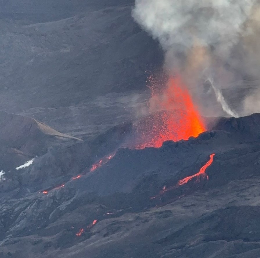
Image taken from Pas de Bellecombe Jacob on February 24, 2026, at 8:05 AM (©OVPF-IPGP)
Estimating surface lava flow rates allows us to track the volume of lava emitted at the surface; thus, since the beginning of the eruption, approximately 6 million cubic meters (Mm3) have been emitted at the surface.
The current absence of renewed inflation of the volcano, seismic activity, and the relatively low levels of tremor and eruptive flow rates suggest the establishment of an equilibrium between the magma feeding the shallow reservoir and that emitted at the eruptive site, without significant repressurization of this reservoir. These observations reduce, in the short term, the probability of a new fissure opening. However, the observatory remains vigilant. Indeed, in the past, eruptive fissures have opened during eruptions without warning, such as in August 1998, July 1999, October 1999, December 2006, and March 2019. In fact, the propagation of magma at shallow depths can occur aseismically, particularly when the magma has already degassed.
Alert Level 2.1
Source : OVPF/ IPGP.
Photos : Papangue ULM , OVPF.
Italy , Stromboli :
Press release on Stromboli activity, February 23, 2026, 03:08 (02:08 UTC).
The National Institute of Geophysics and Volcanology, Etna Observatory, announces that analysis of surveillance camera images shows that, starting at approximately 00:00 UTC, effusive activity is underway due to lava overflowing from the northern area of the crater, producing a lava flow whose fronts are located in the upper part of the Sciara del Fuoco.
From a seismic perspective, the average amplitude of volcanic tremor is currently within normal limits. No significant changes have been reported in the frequency and amplitude of explosion earthquakes.
No significant changes have been observed in GNSS network data.
Further updates will be provided soon.
Source : INGV.
Photo : Stromboli stati d’animo / Sebastiano Cannavo .
Indonesia , Ili Lewotolok :
Ili Lewotolok volcano activity level was reduced from Level III (SIAGA) to Level II (Waspada) on February 24, 2026, effective 6:00 AM WITA.
Ili Lewotolok volcano was placed on alert level III (SIAGA) on January 18, 2026, following an intensification of its eruptive activity, characterized by lava flows escaping from the West Crater. After this increase in activity, Ili Lewotolok’s volcanic activity remained elevated until mid-February 2026, at which point it gradually decreased, and lava flows in the West Crater ceased to be observed.
Seismic data collected from February 1st to 15th, 2026, recorded 1,760 eruption earthquakes, 4,410 emission earthquakes, 21 harmonic tremors, 81 non-harmonic tremors, 2 shallow volcanic earthquakes, 10 deep volcanic earthquakes, 3 local tectonic earthquakes, and 9 distant tectonic earthquakes. From January 16th to 22nd, 2026, 400 eruption earthquakes, 1,592 seismic tremors, 3 non-harmonic tremors, 1 hybrid earthquake, 1 shallow volcanic earthquake, 14 deep volcanic earthquakes, 5 local tectonic earthquakes, and 2 distant tectonic earthquakes were recorded.
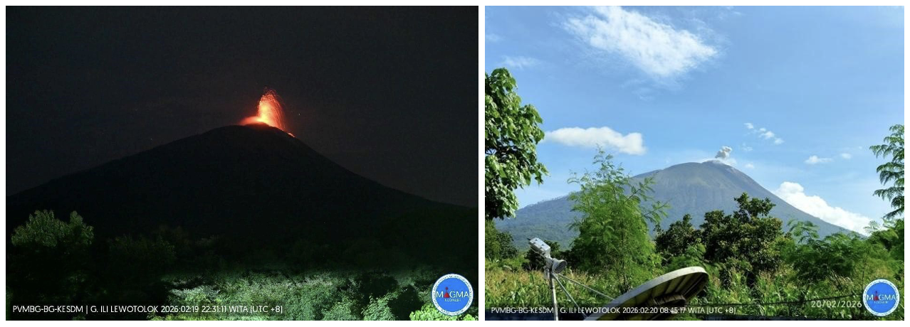
From January 16 to 22, 2026, the volcano was clearly visible until it became shrouded in fog. White and gray smoke, of low to moderate intensity, rose from the crater to a height of 5 to 100 meters above the summit. The eruptive column, white to gray in color, extended 50 to 200 meters above the summit. The ejected material fell back mainly in the area around the crater. The eruption was accompanied by a low to moderate rumbling sound. Lava flows in the western sector ceased.
Following visual and instrumental observations, the volcanic activity of Mount Ili Lewotolok has decreased. Therefore, its activity level has been lowered from Level III (SIAGA) to Level II (WASPADA) effective February 24, 2026, at 6:00 AM (Central Indonesia Time), and the following recommendations are issued:
Residents living near Mount Ili Lewotolok, as well as visitors, climbers, and tourists, are advised to refrain from all activities within a 2-kilometer radius of the activity center. They should be aware of the risk of lava avalanches and pyroclastic flows in the south, southeast, west, and northeast sectors of Mount Ili Lewotolok. Residents living around Mount Ili Lewotolok are advised to wear masks and other protective equipment to protect their eyes and skin, prevent acute respiratory infections (ARIs) and other health problems, and to cover containers of clean water to avoid exposure to volcanic ash.
Source : PVMBG.
Photo : Magma Indonésie.
Chile / Argentina , Laguna del Maule :
For the period under review, volcano-tectonic (VT) seismic activity, associated with rock fracturing within the volcano, showed a decrease in both the number of recorded events and their energy release compared to the previous period.
The most energetic recorded VT event had a local magnitude (ML) of 2.4 and was located 5.4 km south-southeast (SSE) of the lake center, at a depth of 4.5 km.
Seismic activity associated with fluid movement within the volcano, represented by long-period (LP) events, recorded a lower number of events and lower energy levels than in the previous period. The most energetic event, measured by its reduced displacement (DR), recorded a value of 5.2 cm².
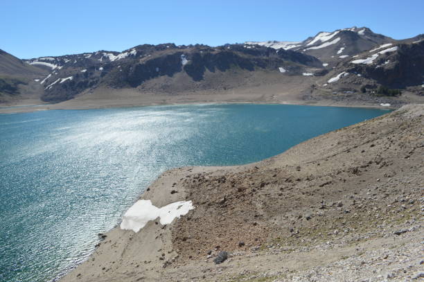
The use of interferometric radar (InSAR) with Sentinel-1 images allowed observation of the continued uplift process, with vertical deformation rates slightly lower than in previous periods, but still high compared to the baseline value. Images from surveillance cameras installed near the volcanic complex revealed no associated surface activity. Furthermore, processing of the satellite images detected no thermal anomalies related to the volcanic complex.
RECOMMENDATIONS
The area within a 2 km radius of the passive CO₂ vent in Chilean territory is considered a risk zone. Stay informed about the evolution of volcanic activity and avoid approaching the passive vent.
Use only official sources for information. It is recommended that you inquire about volcanic risk prevention measures with the National Integrated Risk Management System (SINAGIR) and the civil protection authorities of neighboring municipalities.
The yellow technical alert level indicates an increase in volcanic activity.
Source : Segemar .
Photo : Claudio Arriagada.
Costa Rica , Rincon de la Vieja :
Latitude: 10.83°N;
Longitude: 85.34°W;
Altitude: 1916 m above sea level.
Current activity level: Alert.
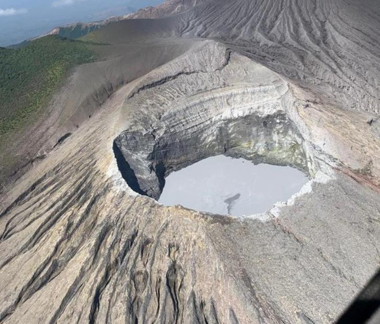
A small eruption was recorded on February 17; however, eruptive activity has been very low since January 6, 2026. A slight increase in tremor amplitude was observed this week, following a short sequence of brief shaking. This tremor preceded the eruption, and its amplitude subsequently decreased. Long-period, tornillo-like events of stable amplitude continue to occur. The geodetic network shows no significant deformation. This week, DOAS stations recorded an SO₂ flux of 64 ± 15 t/d, slightly lower than the previous week (97 ± 51 t/d). The last satellite detection of SO₂ in the atmosphere was in September 2025 (28 tonnes).
Source : Ovsicori .
Photo : Chris Allen / Sunquest helitours / RSN