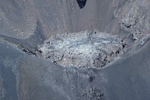
Indonesia , Ili Lewotolok :
An eruption occurred on Mount Ili Lewotolok on Saturday, January 17, 2026, at 7:45 PM WITA. An ash column was observed approximately 300 meters above the summit (about 1,723 meters above sea level). This thick, white to gray column was moving eastward. The eruption was recorded by a seismograph with a maximum amplitude of 33.5 mm and a duration of 60 seconds.
Seismicity observations:
466 eruption earthquakes with amplitudes ranging from 12.8 to 36.2 mm and durations of 41 to 85 seconds.
320 emissions earthquakes with amplitudes ranging from 5.1 to 16.7 mm and durations of 26 to 43 seconds.
44 non-harmonic tremors with amplitudes ranging from 5.4 to 9.7 mm and durations of 100 to 140 seconds.
A low-frequency earthquake with an amplitude of 5.1 mm and a duration of 24 seconds.
Recommendations
1. Residents living around Mount Ili Lewotolok, as well as visitors, climbers, and tourists, are advised to refrain from all activities within a 2 km radius of the Mount Ili Lewotolok activity center and within a 2.5 km radius of the South-Southeast and West sectors.
2. Be vigilant for the risk of lava avalanches and pyroclastic flows in the South, Southeast, West, and Northeast sectors of Mount Ili Lewotolok. The public is advised not to panic if they hear rumbling or crashing sounds coming from the Mount Ili Lewotolok crater, as these sounds are characteristic of volcanic activity during an eruptive phase.
Source et photo : Magma Indonésie.
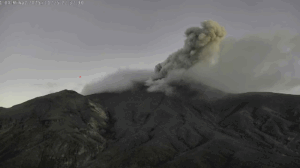
Indonesia , Gamalama :
VOLCANO OBSERVATORY NOTICE FOR AVIATION – VONA
Issued : January 16 , 2026 .
Volcano : Gamalama (268060)
Current Aviation Colour Code : YELLOW
Previous Aviation Colour Code : yellow
Source : Gamalama Volcano Observatory
Notice Number : 2026GML005
Volcano Location : S 0 deg 48 min 00 sec E 127 deg 19 min 48 sec
Area : North Maluku, Indonesia
Summit Elevation : 5488 FT (1715 M)

Volcanic Activity Summary :
Increasing in volcanic activity.
Volcanic Cloud Height :
Ash-cloud is not observed.
Other Volcanic Cloud Information :
Ash-cloud is not observed.
Remarks :
The volcano is clearly visible. Weather conditions range from cloudy to overcast, with winds varying from light to strong, blowing toward the south
Seismic Observations
One local tectonic earthquake with an amplitude of 11 mm, a magnitude of 8.97, and a duration of 20.45 seconds.
Six tectonic earthquakes, spaced 2 to 42 mm apart, with a magnitude of 14.92 and a duration of 61.87 to 129.2 seconds.
Recommendations
(1) Communities living near Mount Gamalama and visitors/tourists are advised to avoid all activity within a 1.5 km radius of the summit crater.
(2) During the rainy season, residents living near rivers originating on Mount Gamalama should be vigilant for the potential risk of lahar flows.
Source et photo : PVMBG.
La Réunion Island , Piton de la Fournaise :
Press release from the Paris Institute of Earth Physics, Piton de la Fournaise Volcanological Observatory, January 16, 2026 – 9:30 a.m. local time – 5:30 a.m. UTC
Seismicity
Seismic activity beneath Piton de la Fournaise continues, although it has slowed since January 10, 2025, decreasing from an average of thirty shallow volcano-tectonic earthquakes per day to five. These earthquakes, located between 1.5 and 2.2 km deep, remain primarily situated beneath the northern and southern rims of the Dolomieu crater.
Over the past seven days, deep volcano-tectonic seismicity has persisted, but with a notable decrease. The low magnitude of these earthquakes makes them difficult to locate. Two deep events were located at approximately 3.5 km deep, beneath the western rim of the summit. This deep seismicity suggests that the supply of magma from deep zones to the volcano’s shallow magma system is continuing, although this supply appears to be decreasing compared to the previous week.
Deformation
After a period of inactivity that began on December 14, inflation (swelling) of the edifice resumed at the end of December, just before the magma intrusion of January 1, 2026. Since this intrusion, inflation has persisted, indicating that the pressurization of the shallow magma supply system continues.
Overall
Since the magma intrusion of January 1, 2026, seismicity and inflation have persisted, indicating that the shallow magma supply system remains under pressure. The decrease in seismicity, particularly of deep origin, observed since January 10 could suggest a reduction in magma input from deep zones to the shallow magma system.
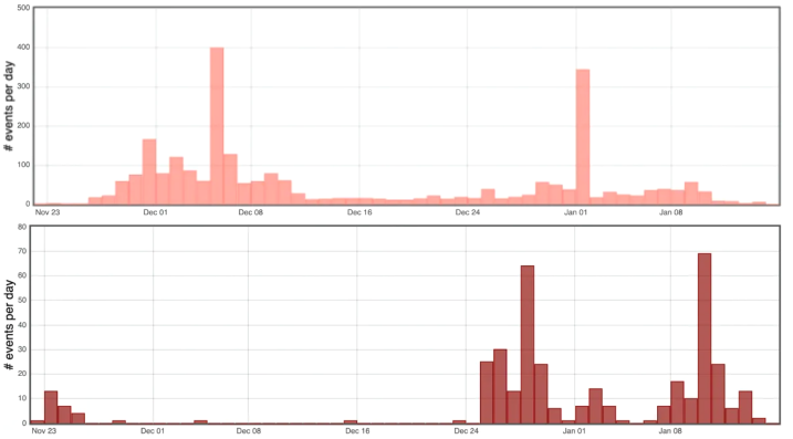
Histogram showing the number of deep (bottom) and shallow (top) volcano-tectonic earthquakes per day recorded since November 22, 2025 (© OVPF-IPGP)
It should be noted that during these pressurization phases, seismic activity beneath Piton de la Fournaise can fluctuate daily, with periods of low seismicity interspersed with periods of higher seismicity. This pressurization process of the shallow reservoir can last from several days to several weeks, or even several months, before the reservoir roof ruptures, resulting in magma injection towards the surface and potentially an eruption. However, it can also cease without leading to an eruption in the short term.
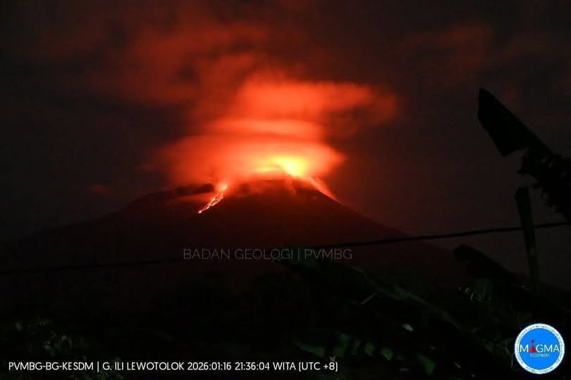
Ecuador , Sangay :
DAILY REPORT ON THE STATE OF SANGAY VOLCANO, Saturday, January 17, 2026.
Information Geophysical Institute – EPN.
Surface Activity Level: Moderate, Surface Trend: Ascending
Internal Activity Level: Moderate, Internal Trend: No Change
Seismicity: From January 16, 2026, 11:00 AM to January 17, 2026, 11:00 AM:
Seismicity:
The table below shows the number of seismic events recorded at the reference station:
Explosion (EXP): 159
Rainfall/Lahars:
Rainfall was recorded in the volcano area, but it did not generate mudflows or debris. **In the event of heavy rain, the accumulated materials could be remobilized, causing mud and debris flows that would cascade down the volcano’s flanks and flow into nearby rivers.**
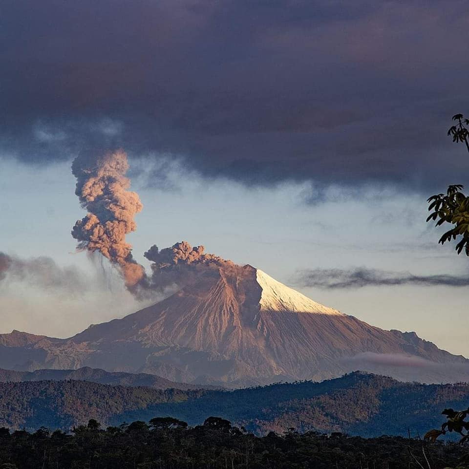
Emission Column / Ash:
Since yesterday afternoon, no gas or ash emissions have been observed by the surveillance camera system. However, several gas and ash emissions were observed by the GOES-19 satellite system, reaching altitudes between 800 and 1,000 meters above the crater level, drifting southwest. In this regard, the Washington VAAC agency published four reports of ash emissions at an altitude of 900 meters above sea level, drifting southwest and west.
Gas:
The MOUNTS satellite system detected 89 tons of sulfur dioxide (SO₂), measured on January 16, 2026, at 2:08 PM local time.
Other monitoring parameters:
Over the past 24 hours, the MIROVA FIRMS satellite system recorded 6 thermal anomalies, the MIROVA OLI 1 system, and the MIROVA VIIRS 3 system.
Observation:
From yesterday afternoon until the publication of this report, the volcano remained mostly covered in clouds.
Alert level: Yellow
Source : IGEPN
Photo : Volcan Sangay / FB.
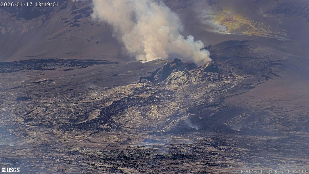
Hawaii , Kilauea :
HAWAIIAN VOLCANO OBSERVATORY DAILY UPDATE , U.S. Geological Survey
Saturday, January 17, 2026, 9:26 AM HST (Saturday, January 17, 2026, 19:26 UTC)
19°25’16 » N 155°17’13 » W,
Summit Elevation 4091 ft (1247 m)
Current Volcano Alert Level: WATCH
Current Aviation Color Code: ORANGE
Activity Summary:
The eruption of Halemaʻumaʻu at the summit of Kīlauea is paused. The current forecast for the onset of the next lava fountaining episode is currently between January 20 to 25, 2026 based on current inflation models. Sporadic earthquake swarm activity continues at the summit, with the most recent occurring just after 5:07 AM HST this morning. No significant activity has been noted along Kīlauea’s East Rift Zone or Southwest Rift Zone.
Summit Observations:
Overnight webcam views show consistent glow from the south vent and weak sporadic glow from the north vent. Seismic tremor spikes gradually became more ragged yesterday and were replaced by relatively constant tremor before midnight yesterday. Constant low-level tremor continues this morning.
Small seismic swarms continue at the summit, with one at 4:10 PM HST, January 16th and another this morning at 5:07 AM HST. Both were beneath the southeast part of Halemaʻumaʻu and lasted for 10-20 minutes. While the swarm earthquakes were close in time, the locations were spread fairly widely. There was also a magnitude 2.2 earthquake south of Halemaʻumaʻu at 8:22 AM HST this morning, but it is uncertain if this was related to the earlier activity. All of the detected earthquakes in swarms have been less than magnitude-2, with most being magnitude-1 or smaller and 0.5 to 2 miles (1-3 kilometers) deep. The swarms are related to migrating magmatic pressure within the summit region but their impact on the next episode of fountaining, if any, is unknown at this time.
Since the end of episode 40, the UWD tiltmeter has recorded 10 microradians of inflationary tilt, with an increase of 1.2 microradians in the past 24 hours. Summit tiltmeters began recording slightly deflationary tilt during the 5 AM HST swarm, before flattening. Other summit swarms have been associated with tilt drops, but the changes during the 5 AM HST swarm were longer and more gradual than previously.
The summit SO2 emission rate was last measured on January 15, at 1550 tonnes per day, which is within the typical range of 1,000 to 5,000 tonnes of SO2 per day observed during previous eruptive pauses and is considerably lower than rates observed during fountaining episodes.
Rift Zone Observations:
Rates of seismicity and ground deformation remain very low in the East Rift Zone and Southwest Rift Zone. SO2 emissions from the East Rift Zone remain below the detection limit.
Source et photo : HVO.