September 02 , 2025.
Canary Islands , Tenerife :
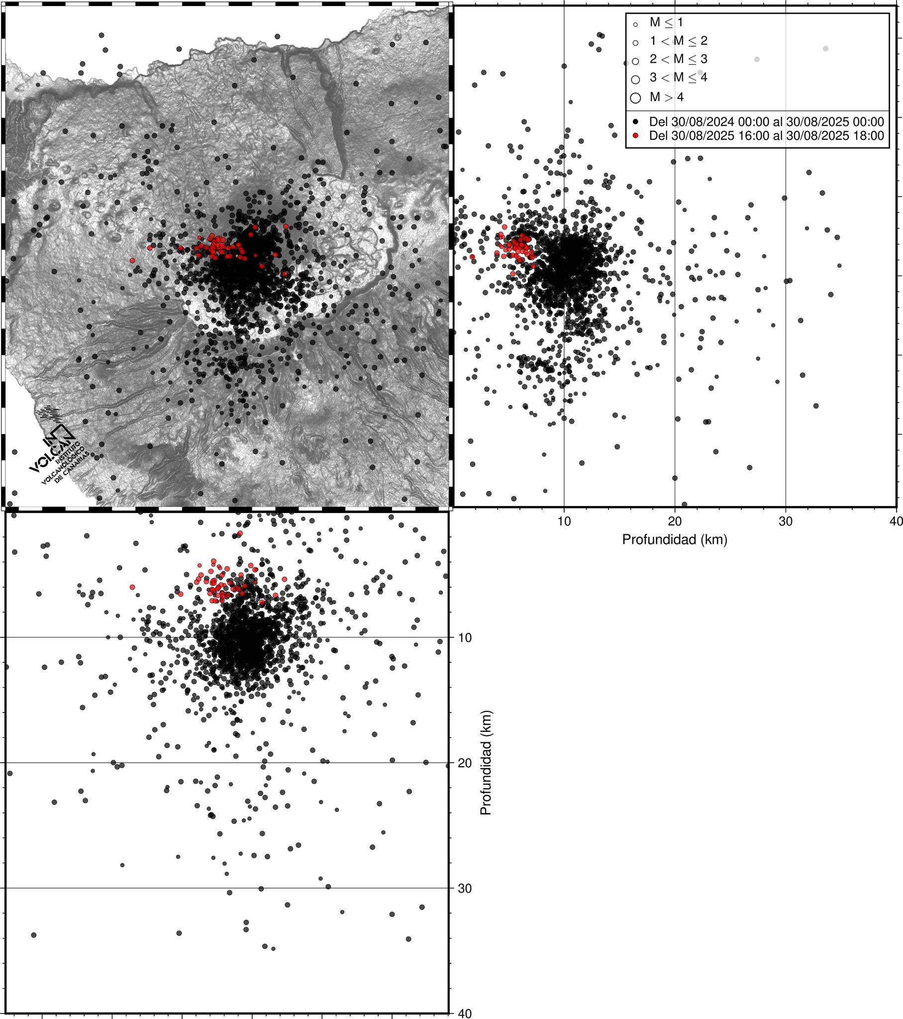
New seismic swarm in Tenerife:
On August 30, 2025, between 5:14 p.m. and 6:26 p.m. (Canary Islands time), the INVOLCAN seismic network recorded a volcano-tectonic seismic swarm. In total, more than 100 small earthquakes were detected, 49 of which were precisely located. All events occurred beneath the Teide-Pico Viejo volcanic complex, at depths between 4 and 7 kilometers. The highest magnitude reached M = 1.2; therefore, no earthquake was felt by the population.
Is this a volcanic earthquake?
Volcano-tectonic earthquakes are caused by the fracturing of rocks within the volcano, facilitated by the presence of pressurized fluids (such as hot water or gases). They generally occur in the form of seismic swarms, i.e., groups of earthquakes concentrated in time and with similar hypocenters. This type of seismic activity is very common in active volcanoes, and in the case of Tenerife, more than 110 such swarms have been recorded since 2017.
The origin of the latest swarm, like the previous ones, could be linked to the injection of magmatic fluids into the island’s hydrothermal system. This process has been observed several times since 2016 and is reflected in other indicators, such as:
• Increased CO₂ emissions from the Teide crater. • Slight deformation of the ground northeast of the peak, detected since 2024.
Will the peak continue to experience seismic activity?
The available information does not allow us to confirm that the probability of an eruption has increased in the short or medium term. However, the persistence of signals consistent with deep volcanic activity, such as recurrent seismic activity, increased gas emissions, and ground deformation, indicates that the volcanic system remains active; long-term evolution cannot therefore be ruled out.
Therefore, INVOLCAN maintains and strengthens volcanic monitoring in Tenerife through permanent monitoring networks and periodic scientific campaigns.
Source : Involcan
Photos : Involcan , webtenerife fr. com
Indonesia , Lokon :
Increased Seismicity at Mount Lokon, Level II (Waspada) – September 2, 2025, 6:00 a.m. (local time)
Lokon Volcano is located in the administrative city of Tomohon, North Sulawesi Province, at 1021’30″N latitude and 124047’30″E longitude, with a peak elevation of approximately 1,579 m above sea level.
From midnight to 6:00 a.m. (local time), an increase in superficial volcanic seismicity at Mount Lokon occurred on September 2, 2025. The last eruption occurred in 2015, producing ash plumes and the ejection of incandescent material that fell back into the crater area. Mount Lokon’s activity level has been Level II (Waspada) since January 30, 2025, and remains at this level to date.
From August 2025 to September 1, 2025, volcanic activity generally produced thin to moderate white plumes approximately 10 meters high. Seismic activity was dominated by shallow volcanic earthquakes, with between 1 and 37 events recorded per day.
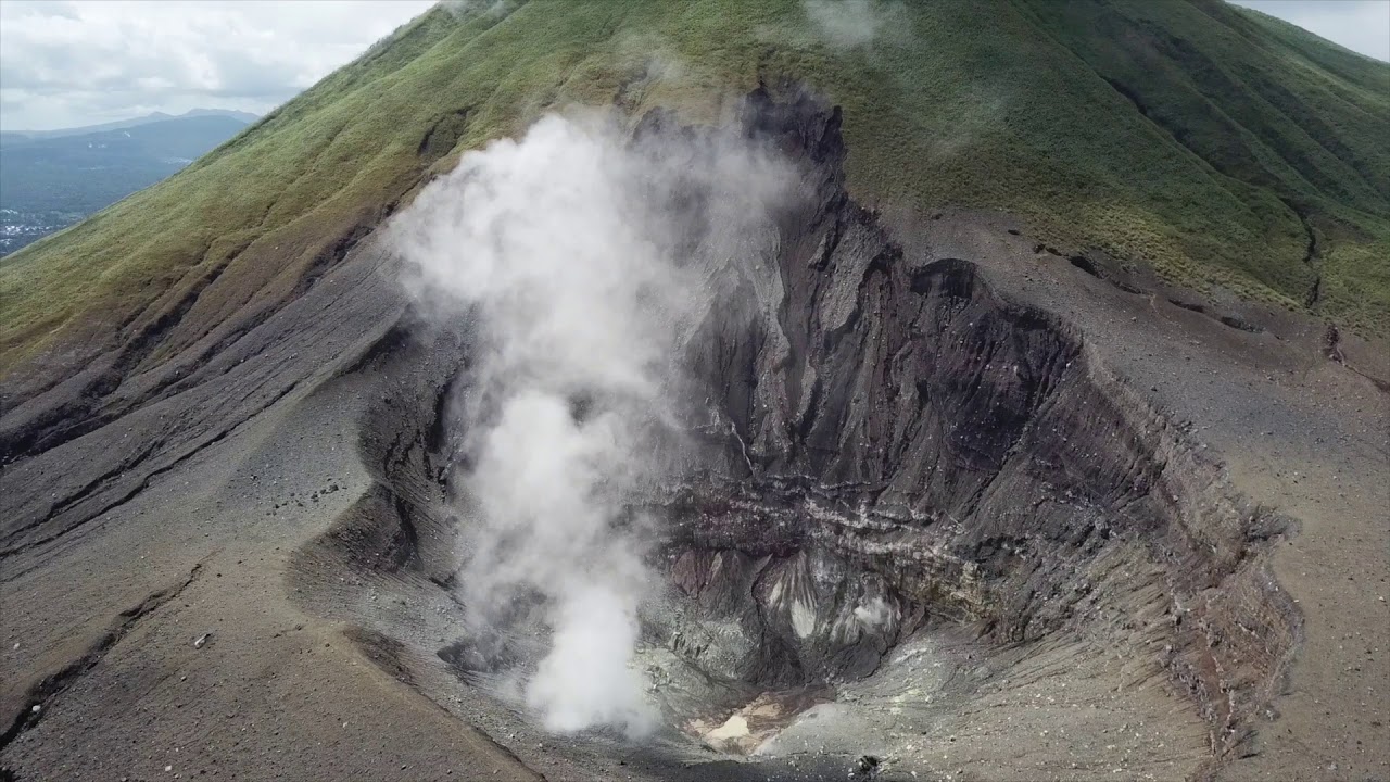
The latest developments at Mount Lokon on September 2, 2025, from 00:00 to 06:00 WITA (Central Indonesian Time) are as follows:
Visual conditions remained unchanged, with thin white plumes emerging from the crater, approximately 10 meters high.
Seismic activity increased, including 35 shallow volcanic earthquakes, 25 emission earthquakes, 4 deep volcanic earthquakes, and 5 distant tectonic earthquakes.
Instrumental data indicate an increase in pressure in the shallow (surface) zone following the recording of shallow volcanic earthquakes associated with the release of explosive gases.
The current potential threat from Mount Lokon’s activity is a sudden phreatic eruption (an eruption caused by the contact of magma vapors with hydrothermal fluid), with or without signs of significant increase. During the rainy season or during heavy rainfall at the summit of Mount Lokon, caution should be exercised regarding lahars in the rivers that originate there.
Based on observations, analyses, and evaluation of visual and instrumental data, the activity level of Mount Lokon remains at Level II (waspada) until September 2, 2025.
Source : PVMBG.
Photo : lumbalumba resort , Manado
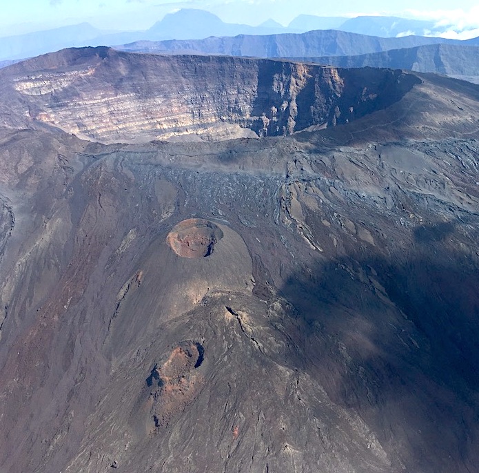
Chile , Planchon-Peteroa :
Seismology
Seismological activity during this period was characterized by:
62 VT-type earthquakes, associated with rock fracturing (volcano-tectonics). The most energetic earthquake had a local magnitude (LM) of 2.3, located 5.8 km northeast of the volcanic edifice, at a depth of 5.3 km.
7,049 LP-type earthquakes, associated with fluid dynamics within the volcanic system (long period). The most energetic earthquake had a reduced displacement (RD) of 11 cm² and a local magnitude (LM) of 1.5, located 2.4 km northeast of the volcanic edifice, at a depth of 1.6 km.
2,494 TR-type earthquakes, associated with sustained fluid dynamics within the volcanic system (TRemor). The magnitude of the largest earthquake, estimated using the reduced displacement (RD) parameter, was 7 cm².
Fluid Geochemistry
No atmospheric sulfur dioxide (SO₂) emission anomalies were reported near the volcanic complex, according to data published by the Tropospheric Monitoring Instrument (TROPOMI) and the Sulfur Dioxide Group of the Ozone Monitoring Instrument (OMI).
Satellite Thermal Anomalies
During the first half of August, no thermal alerts attributable to volcanic activity were recorded for the volcanic complex, according to the Mid-Infrared Volcanic Activity Observation, reported by MIROVA. Meanwhile, no other thermal radiance anomalies were identified through analytical processing of Sentinel 2-L2A satellite images, using a combination of false-color bands.

Geodesy
Geodetic activity during the period was characterized by:
– GNSS vertical deformation rates, with magnitude variations of less than 0.2 cm/month, a value considered low.
– Horizontal variation rates at GNSS monitoring stations, with variations of around 0.2 cm/month, a value considered low.
Surveillance Cameras
Images provided by the fixed camera, installed near the volcanic complex, recorded degassing episodes reaching a maximum height of 120 m above the crater level.
It should be noted that outside the evaluation period of this report, an increase in degassing intensity was recorded on August 18, reaching a height of 500 m above the crater level, without the identification of pyroclastic material.
Satellite Geomorphological Analysis
No morphological variations attributable to volcanic activity were recorded during this period. The source of the degassing was identified in the Southwest Crater, which features a crater lake.
The Planchón-Peteroa volcanic complex maintains activity above its base level, dominated by seismic activity associated with fluid dynamics (PL and tremor) with high productivity. An increase in VT seismic activity was recorded, preceded by transient increases in RSAM and changes in the spectral content of the seismic signals. Together, these events suggest heat transfer from deeper levels that activated the hydrothermal system, leading to greater surface degassing. A plausible interpretation is the progressive pressurization of the system, which could trigger an increase in gas flow toward the surface. Although other monitoring parameters remain stable, this behavior preceded previous eruptive cycles, mainly associated with pyroclastic material emissions. In light of the above, the Volcanic Technical Alert remains in effect:
YELLOW TECHNICAL ALERT: Changes in volcanic activity behavior
Source et photo : Sernageomin
La Réunion , Piton de la Fournaise :
Observations
In August 2025, the OVPF-IPGP recorded a total of:
• 10 shallow volcano-tectonic earthquakes (0 to 2.5 km above sea level) beneath the summit craters;
• 6 deep earthquakes (below sea level);
• 2 long-period earthquakes;
• 168 rockfalls.
August 2025 was marked by low seismicity beneath Piton de la Fournaise, with only 10 shallow volcano-tectonic earthquakes and 6 deep earthquakes recorded.
Only 2 shallow and 3 deep volcano-tectonic earthquakes were located beneath the Dolomieu crater and beneath the volcano’s northern and eastern flanks, respectively. The others – of lower magnitude – could not be located.
Numerous (168) landslides in the Dolomieu crater, at the ramparts of Enclos Fouqué and at Cassé de la Rivière de l’Est were also recorded.
Deformations
After resuming in February 2024, the edifice’s inflation stopped at the beginning of April 2024.
Since then, a slight deflation has been observed over the long term, particularly clearly visible at the summit stations.
Since May 2025, deflation appears to have slowed. In the absence of data from two of the summit stations and from the distant baselines (consequences of damage caused by Cyclone Garance on February 28, 2025), this trend remains to be confirmed in the coming weeks/months.
Summary
Since April 2024, magma replenishment and pressurization of the shallow reservoir have ceased.
In August 2025, seismicity remained low, with only 10 shallow volcano-tectonic earthquakes and 6 deep earthquakes recorded. A slight summit deflation is still observed, and the August 2025 data confirm the general downward trend in CO2 emissions recorded since the last eruption of Piton de la Fournaise.
Source et photo: OVPF.
Guatemala , Santiaguito :
Atmospheric Conditions: Clear
Wind: Northeast
Precipitation: 33.8 mm
Activity
White degassing is observed above the Caliente dome, with fumaroles rising up to 100 m and dispersing towards the southwest. Two to three weak to moderate explosions are generated per hour, lifting columns of gas and ash up to 800 m above the dome, in the same direction. During the night and early morning, incandescence was recorded in the crater, accompanied by collapses and the fall of incandescent blocks on its flanks.
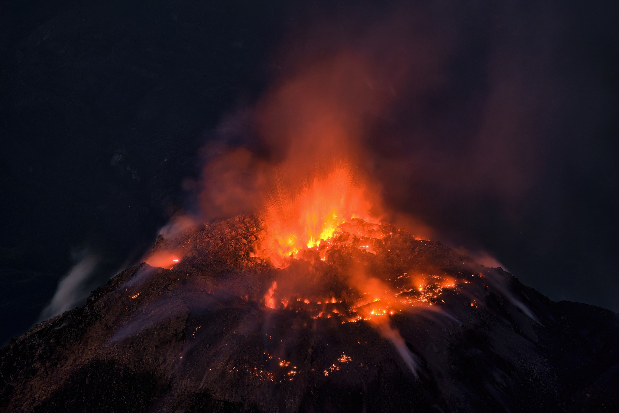
Given the high level of activity and the risk of major collapses, the generation of long-distance density pyroclastic currents, regardless of direction, cannot be excluded; it is therefore recommended to follow the instructions of Special Bulletin BESAN-063-2025. In addition, precipitation can mobilize debris accumulated in ravines and riverbeds, causing lahars. It is recommended to avoid ravines and riverbeds and strictly follow the instructions of Special Bulletin BESAN-012-2025.
Source : Insivumeh .
Photo : Thomas Spinner via FB .