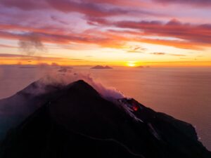
June 06 , 2025.
Hawaii , Kilauea :
HVO/USGS Volcanic Activity Notice
Current Volcano Alert Level: WATCH
Current Aviation Color Code: ORANGE
Issued: Wednesday, June 4, 2025, 10:51 PM HST
Source: Hawaiian Volcano Observatory
Notice Number: 2025/H258
Location: N 19 deg 25 min W 155 deg 17 min
Elevation: 4091 ft (1247 m)
Area: Hawaii
Volcanic Activity Summary:
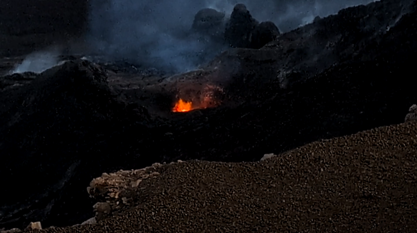
Episode 24 of the ongoing Halemaʻumaʻu eruption began at 8:55 PM HST on June 4 and is currently fountaining from the north vent.
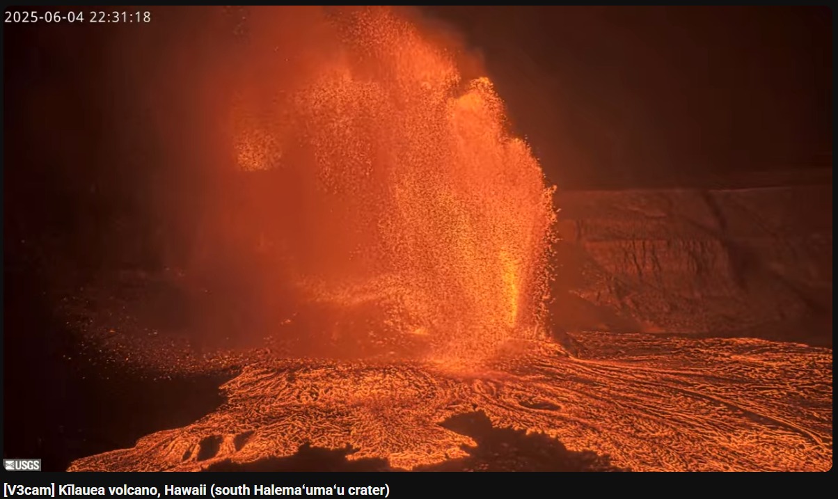
Episode 24 was preceded by sporadic spatter, gas pistoning, and hydrogen flames that began on the morning of June 3. At approximately 8:55 PM HST, episode 24 began with low dome fountaining accompanied by lava flows onto the crater floor. Small sustained lava fountains, less than about 100 feet (30 meters) high, began erupting from the north vent around 9:15 PM. Activity increased again around 10:10 PM, when fountain heights increased to 325 feet (100 meters) and by 10:40 reached over 980 feet (300 meters). Additionally, the fountain generated a plume that reached 16,500 feet (5,000 meters) above ground level by 10:50 PM and is increasing.
At a tiltmeter near Uēkahuna (UWD), inflationary tilt reached just over 14 microradians since the end of the last episode; slightly more than the amount of deflationary tilt in episode 23. Seismic tremor began increasing and tilt at UWD switched from inflation to deflation at about 9:00 PM HST, close in time to the beginning of low fountaining.
Most episodes of Halemaʻumaʻu lava fountaining since December 23, 2024, have continued for around a day or less and have been separated by pauses in eruptive activity lasting generally at least several days.
No changes have been detected in the East Rift Zone or Southwest Rift Zone. A VAN/VONA will be issued when sustained lava fountaining ceases and the eruption is paused, or earlier if the situation warrants a further update.
HVO/USGS Volcanic Activity Notice . Issued: Thursday, June 5, 2025, 5:37 AM HST
Volcanic Activity Summary:
Episode 24 of the ongoing Halemaʻumaʻu eruption ended abruptly at 4:28 a.m. HST on June 5.
The north vent stopped erupting at approximately 4:08 a.m. HST. The south vent stopped erupting at approximately 4:28 a.m. HST, marking the end of the episode. Lava flows from this episode on the floor of Halemaʻumaʻu within the southern part of Kaluapele (Kīlauea caldera) may continue to exhibit slow movement or incandescence as the cool and solidify over the coming days.
The Uēkahuna tiltmeter (UWD) recorded appriximately 13 microradians of deflationary tilt during this episode. The end of the eruption was coincident with a rapid change from deflation to inflation at the summit and a decrease in seismic tremor intensity.
No changes have been detected in the East Rift Zone or Southwest Rift Zone. HVO continues to closely monitor Kīlauea and will issue a VAN/VONA at the start of the next eruptive episode.
Kīlauea Volcano Alert Level/Aviation Color Code remain at WATCH/ORANGE. All current and recent activity is within Hawaiʻi Volcanoes National Park.
Source et photo: HVO
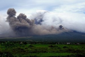
Guatemala , Fuego :
Information Bulletin 194-2025
The CONRED system is continuously monitoring the Fuego volcano following the increase in its effusive activity recorded on June 4, according to Special Bulletin BEFGO No. 023-2025 published by INSIVUMEH. Intense degassing, incandescence in the crater, and a 600-meter lava flow toward the Seca-Santa Teresa ravine are currently being observed. Up to 10 explosions per hour and constant rumbling noises are also being reported.
PYROCLASTIC FLOWS FROM FUEGO VOLCANO REACH UP TO 7 KILOMETERS
Written by CONRED on June 5, 2025.
Bulletin No. 197-2025
As part of the Fuego Volcano Activity Update, INSIVUMEH reports that several pyroclastic flow pulses have been recorded, traveling distances of up to 7 kilometers, mainly along the Las Lajas, Ceniza, and Seca ravines.
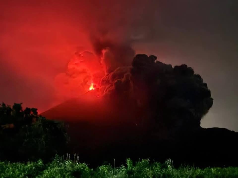
These flows vary in intensity, from moderate to severe, generating columns of gas and ash rising several meters high. Due to the wind direction, the ash is moving west and northwest, causing ashfall in the municipalities of Acatenango and San Pedro Yepocapa.
In response to this phenomenon, the Ministry of Environment and Natural Resources (SE-CONRED) has issued an institutional orange alert, an internal measure intended for the staff of the CONRED Executive Secretariat and the system’s inter-institutional liaison officers. This alert is activated in accordance with the National Response Plan (PNR), with the aim of reducing risks, strengthening disaster preparedness and response, and protecting the lives and livelihoods of the population.
Currently, the institutions that make up the CONRED system are continuously monitoring the volcano and have initiated preventive measures, including the evacuation of people from neighboring communities, who are being transferred to the shelter set up at the Santa Lucía Cotzumalguapa Sports Center.
SE-CONRED strongly encourages the public to keep their 72-hour emergency backpack handy. If authorities request an evacuation, it is imperative to do so immediately. The principle of self-evacuation in case of risk is also encouraged. Be careful not to put your life or that of your family in danger. Every minute counts.
Source et photo : Conred
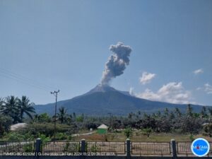
Indonesia , Raung :
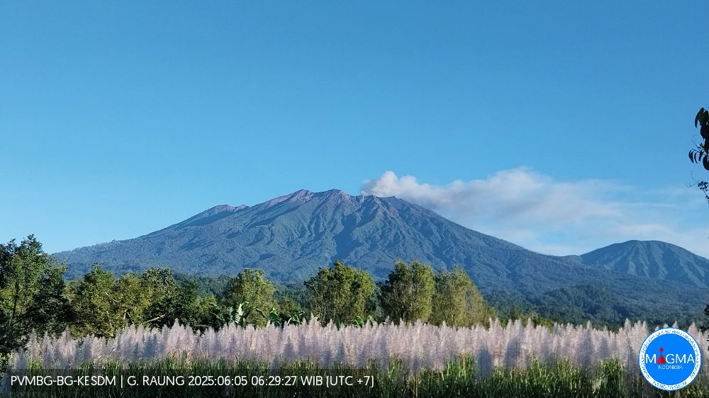
RAUNG VOLCANO ACTIVITY, EAST JAVA, JUNE 5, 2025
Raung Volcano, one of the active volcanoes in East Java, has been on Alert Level II (WASPADA) since December 19, 2023, with a recommendation of no activity within a 3 km radius of the crater/summit. At this alert level, Mount Raung exhibits fluctuating volcanic activity, and an eruption risk is possible at any time. The last eruption of Mount Raung occurred on March 13, 2025, producing an eruptive column approximately 1,500 m above the summit.
On June 5, 2025, continuous gas emissions were observed from 6:00 to 13:00 WIB, white to gray in color and of moderate intensity, with a maximum height of 600 m above the summit. The color of the gas emissions indicates the presence of ash-sized rock materials transported to the surface.
The seismicity of Mount Raung is dominated by surface earthquakes in the form of emissions, with a number of events ranging from 3 to 10 per day during the first week of June 2025. During the same period, one deep volcanic earthquake and four continuous tremors were recorded, with amplitudes ranging from 0.5 to 6 mm (dominant value at 1 mm). However, seismic observations reveal no trend toward increasing energy; the eruption is believed to have originated from a relatively shallow depth.
On June 5, 2025, ash from Mount Raung was scattered around the crater/peak and the northeast sector. To date, the hazard threat to Mount Raung has not changed, nor has the eruption intensity increased; the activity level is therefore still considered relevant, at Level II (WASPADA).
Regarding the volcanic activity of Mount Raung, the public is urged to comply with the recommendations issued by the Geological Agency, through the Centre for Volcanology and Geological Disaster Mitigation, not to be influenced by false and irresponsible information regarding the activity of Mount Raung and to follow the guidelines of the relevant agency, namely the Geological Agency, which will continue to collaborate with the BNPB, BMKG, ministries/institutions, regional governments and other relevant bodies.
Source et photo : PVMBG.
Colombia , Galeras :
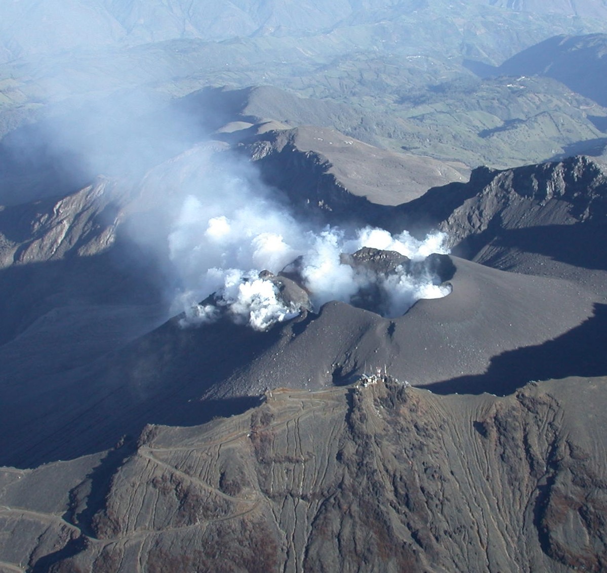
San Juan de Pasto, June 3, 2025, 2:30 p.m.
Regarding the monitoring of the activity of the Galeras Volcano, the Colombian Geological Survey (SGC), an entity affiliated with the Ministry of Mines and Energy, reports that:
During the week of May 27 to June 2, 2025, the main variations in the monitored parameters compared to the previous week were:
● A slight decrease in seismic activity was observed, while the energy released increased. The predominance of seismic activity associated with rock fracturing within the volcanic edifice remained.
● Regarding localized earthquakes, two groups stand out. In the first, the earthquakes were concentrated within a radius of up to 1.6 km from the crater center, at depths less than 4.0 km. The second group of earthquakes was located within a radius of up to 6.5 km northwest of the summit of Galeras Volcano, at depths between 6.0 and 9.0 km. Two magnitude 2.5 earthquakes occurred, located 5.0 and 5.7 km to the northwest, respectively, and at depths of 7.2 and 7.9 km. One of these earthquakes was felt by residents of the municipality of Pasto.
● Low gas emissions were observed, mainly from the fumarole fields of El Paisita, to the north, and Las Chavas, to the west of the active cone. The gas columns were white in color, with variable dispersion influenced by wind direction.
In light of the above, the SGC recommends closely monitoring the situation through weekly bulletins and other information published through our official channels, as well as instructions from local and departmental authorities and the National Disaster Risk Management Unit (UNGRD). Volcanic activity remains on yellow alert: active volcano with changes in the baseline level of monitored parameters and other manifestations.
Source et photo : SGC.
Costa Rica , Rincon de la Vieja :
Lat.: 10.83°N;
Long.: 85.34°W;
Altitude: 1,916 m
Current Activity Level: Warning.
No eruptions or exhalations were recorded this week. The frequency of tornillo-type earthquakes and long-period (LP) earthquakes continues. Since 2:00 PM yesterday, an increase in the number of low-frequency events has been recorded and continues as of the date of this report. Some of these events have a tonal coda. The dominant frequency of tornillos in 2025 remains generally stable, with a slight decreasing trend over the past week.
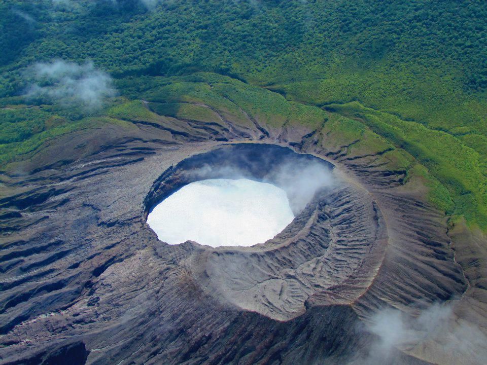
The background volcanic tremor remains of very low amplitude, with a frequency between 2.5 and 6.5 Hz; its amplitude continues to decrease compared to the last two weeks. Sporadic proximal volcano-tectonic (pVT) events and short-term tremors are recorded. Geodetic observations show a slight basal contraction. During the past week, the average SO2 flux was 83 ± 46 t/d, a level similar to that of the previous week (75 ± 35 t/d). The MultiGAS station continues to record low concentrations of volcanic gases.
Source : Ovsicori .
Photo : Raul Mora / RSN / UCR