September 26 , 2026.
Italy / Sicily , Etna :
The reddish-brown plume emitted by Etna’s Northeast Crater: interpretation of ongoing processes.
For several weeks, Etna’s Northeast Crater (NEC) has been intermittently emitting a gas plume characterized by a high concentration of fine particles with a reddish-brown hue; this phenomenon became particularly prominent on September 24. It is occurring in the post-eruptive phase following the intense activity of July–August 2026, during which the Voragine crater (VOR) produced frequent explosions and lava flows—the latter also fed by a system of lateral fissures extending toward the Valle del Bove down to an elevation of approximately 1,900 meters.
During the eruptive phase, some of the lava emitted by Voragine flowed for several days into the NEC’s eruptive conduit without, however, filling it. The lava flow coated the conduit’s inner walls with scoria, volcanic glass, and oxidized material, creating an accumulation of loose, easily remobilized deposits. The VOR-to-NEC lava flow remained active until August 19 before ceasing and cooling.
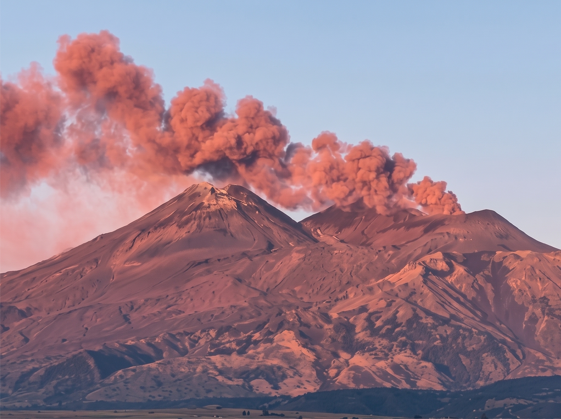
The reddish-brown coloration of the plume is attributable to the presence of solid particles that have undergone significant chemical alteration—rich in degraded iron oxides and glassy fragments. These are likely residues from flows and debris accumulated within the Northeast Crater’s (NEC) eruptive conduit during recent eruptive phases, rather than fragments of fresh magma. These lava materials have been exposed to highly corrosive magmatic gases—specifically sulfur dioxide (SO2), hydrochloric acid (HCl), and hydrofluoric acid (HF). Present in high concentrations within the plume emitted by the NEC, these gases accelerate the natural physicochemical weathering of the lava rock, causing rapid « argillization » (transformation into clay). This phenomenon is consistent with a « clearing-out » phase of the conduit system, characterized by reduced internal pressure and the erosion and scouring of the conduit walls.
In summary, the reddish-brown plume currently being emitted by the Northeast Crater signals the mechanical remobilization of solid material already present in the conduit—a process facilitated by the lowering of the magma column and the consequent reduction in magmatic pressure. Such behavior is typical of post-eruptive phases, during which the volcano transitions from a regime of sustained supply to one of residual degassing.
Source : INGV Vulcani.
Photo : Alfio Landro.
Kamchatka , Sheveluch :
KVERT VOLCANIC ACTIVITY NOTICE (VAN)
Issued: September 25 , 2026
Volcano: Sheveluch (CAVW #300270)
Current aviation colour code: ORANGE
Previous aviation colour code: orange
Source: KVERT
Notice Number: 2026-101
Volcano Location: N 56 deg 38 min E 161 deg 19 min
Area: Kamchatka, Russia
Summit Elevation: 3283 m (10768.24 ft), the dome elevation ~2500 m (8200 ft)
Volcanic Activity Summary:
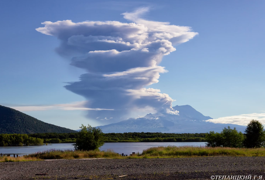
An explosive-extrusive eruption of the volcano continues, accompanied by powerful gas-steam activity; a new block of lava continues to grow in the northern part of the lava dome. Explosion sent ash up to 10.5 km a.s.l on 17:50 UTC September 25, ash cloud moved 150 km to west of the volcano.
This explosive-extrusive eruption of the volcano continues. Ash explosions up to 12 km (39,400 ft) a.s.l. could occur at any time. Ongoing activity could affect international and low-flying aircraft.
Volcanic cloud height:
8600 m (28208 ft) AMSL Time and method of ash plume/cloud height determination: 20260925/2040Z – Himawari-9 14m15
Other volcanic cloud information:
Distance of ash plume/cloud of the volcano: 150 km (93 mi)
Direction of drift of ash plume/cloud of the volcano: W / azimuth 278 deg
Time and method of ash plume/cloud determination: 20260925/2040Z – Himawari-9 14m15
Start time of explosion and how determined: 20260925/1750Z – Satellite data
Duration of explosion: ~ 10 min
Source : Kvert.
Photo : Gennady Teplitsky.
Indonesia , Anak Krakatau :
EMERGENCE OF NEW ISLANDS IN THE NORTHWEST AND SOUTHEAST SECTORS OF THE ANAK KRAKATAU VOLCANO
Anak Krakatau is an active Type A volcano located in the Sunda Strait; it is monitored from the Kalianda (Lampung) and Pasauran (Banten) volcanological observation posts. Krakatau has experienced major eruptions and tsunamis in the past, notably in 1883 and 2018. Following a period of low-intensity eruptive activity that persisted until December 2023, eruptive activity resumed on July 2, 2026.
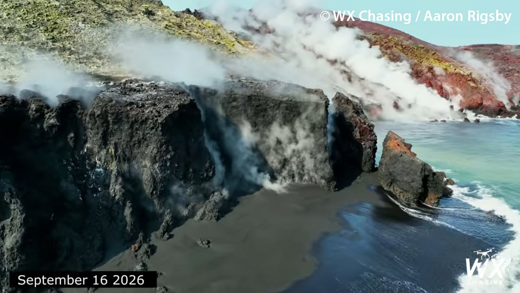
Since July 2, 2026, Anak Krakatau has remained at alert level III. A series of Strombolian-type eruptions, characterized by the ejection of incandescent rocks and volcanic ash, continued until September 3, 2026. On September 4, 2026, at 23:07 (local time, WIB), Anak Krakatau began a continuous eruption lasting 25 hours, which ended on September 6, 2026, at 00:04 (WIB). This continuous eruption produced lava flows extending toward the northwest, west, and southwest sectors. Analysis of Sentinel satellite imagery from September 15, 2026, revealed an expansion of 32.8 hectares in the Anak Krakatau volcanic edifice. Following a decline in activity after the continuous eruption, the volcano’s alert level was lowered from level III (SIAGA) to level II (WASPADA) on September 21, 2026, at 18:30 (WIB).
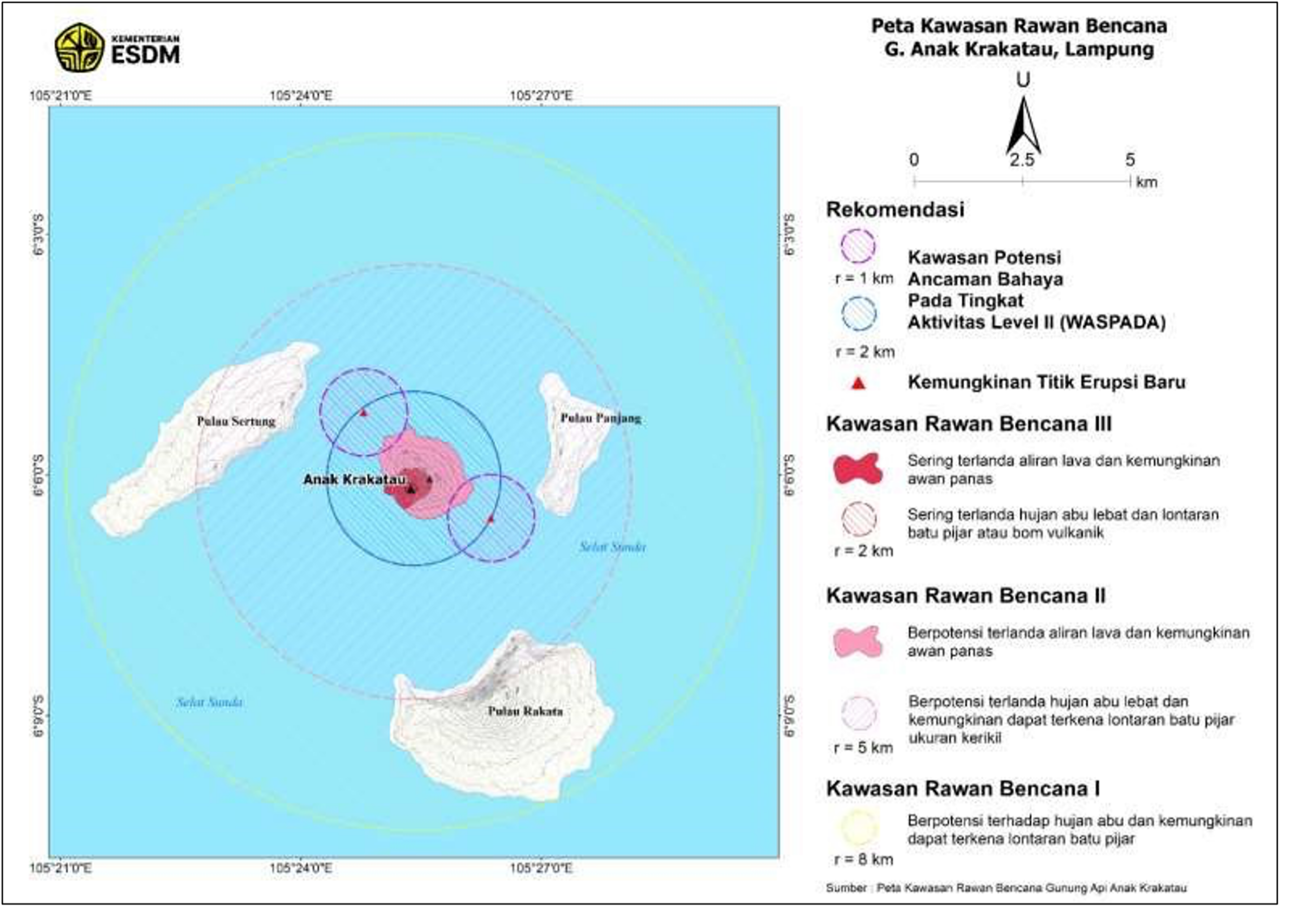
According to information provided by sailors and volunteers who navigated near and photographed the Krakatau volcano area, new islands were observed on September 22, 2026, in the northwest sector (approximately 760 m from Anak Krakatau’s northwest coast) and in the southeast sector (approximately 495 m from Anak Krakatau’s southeast coast). A straight line drawn between these two islands reveals a northwest-southeast alignment, with the Anak Krakatau crater situated between them. The emergence of these two new islands is also visible in Sentinel satellite imagery and is interpreted as being linked to the ongoing eruptions of Anak Krakatau. However, determining whether these islands constitute new eruptive centers requires up-to-date data, analyses, and in-depth studies.
In light of the emergence of these new islands, the Geological Agency issues the following recommendations:
1. Local residents and tourists are prohibited from entering or conducting activities within a 2-kilometer radius of the Anak Krakatau eruption site.
2. Local residents and tourists are prohibited from entering or conducting activities within a 1-kilometer radius of the new islands located in the northwest and southeast sectors.
3. Heightened vigilance is advised regarding the risks of incandescent rock ejections and heavy ashfall, as well as the risk of secondary eruptions caused by contact between molten lava and seawater.
4. Residents of coastal areas in the Banten and Lampung provinces are urged to remain calm and disregard rumors claiming that the Anak Krakatau eruption will trigger a tsunami; they may continue their daily activities while strictly adhering to the directives of the Regional Disaster Management Agency (BPBD).
Source : PVMBG.
Photos : PVMBG , WX chasing / Aaron Rigsby.
Colombia , Nevado del Ruiz :
Manizales, September 22, 2026, 5:00 PM.
As part of the monitoring of activity at the Nevado del Ruiz volcano, the Colombian Geological Service (SGC)—an agency attached to the Ministry of Mines and Energy—reports the following:
During the week of September 15 to 21, 2026, the volcano continued to exhibit unstable behavior. Compared to the previous week, the main variations in monitored parameters were as follows:
– Seismic activity associated with rock-fracturing processes within the volcanic edifice increased—in terms of both the number of events and energy released—relative to the previous week. This seismicity was concentrated near the Arenas crater and on the northwest and north-northwest flanks, extending up to 8 km from the crater. Scattered seismicity was also observed on other flanks of the volcano, up to 12 km from the crater. Earthquake depths ranged from less than 1 km to 10 km. The maximum recorded magnitude was 1.5, corresponding to an earthquake that occurred on September 17 at 2:12 PM, located 10 km north-northeast of the crater at a depth of 6 km.
– Seismicity associated with fluid dynamics within the volcanic conduits remained stable in terms of the number of earthquakes, with slight variation in the seismic energy released. This seismic activity was characterized by short-duration, low-energy signals. As in previous weeks, no long-duration seismic signals were recorded, and no ash emissions or changes in the apparent temperature of the gas column were confirmed.
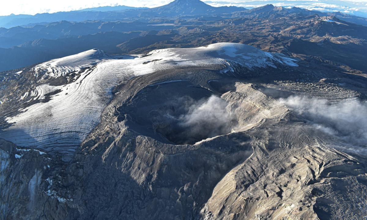
– Emissions of water vapor and volcanic gases—primarily sulfur dioxide (SO₂)—into the atmosphere continued at the Arenas crater. The estimated SO₂ flux associated with degassing processes increased compared to values recorded the previous week. Satellite monitoring also confirmed this rise, although SO₂ emission levels remained low.
– The gas and water vapor column maintained a vertical height of less than 600 m above the volcano’s summit, with dispersion directed primarily toward the northwest, west-northwest, and north-northwest sectors of the volcanic edifice.
– Satellite monitoring of thermal anomalies at the base of the Arenas crater detected a few low-energy anomalies, although observations were limited by cloud cover in the area.
Source and photo: SGC.
Martinique , Mount Pelée :
Weekly Report – Institut de physique du globe de Paris / Martinique Volcanological and Seismological Observatory
Saint-Pierre, September 25, 2026, at 4:00 PM local time (GMT-4)
Volcano-tectonic seismic activity
Between September 18, 2026, at 4:00 PM (UTC) and September 25, 2026, at 4:00 PM (UTC), the OVSM recorded 198 earthquakes of volcanic origin:
– 181 volcano-tectonic earthquakes. The largest had a magnitude of Mlv = 0.93; the others were of lower energy. These earthquakes were located at depths between 1 and 1.4 km beneath the volcano’s summit.
– 15 low-energy, shallow hybrid earthquakes. These earthquakes were located at a depth of approximately 1 km beneath the volcano’s summit.
– 2 low-energy, shallow long-period earthquakes, located at a depth of approximately 1 km beneath the volcano’s summit. The largest had a magnitude of Mlv = 0.6.

No earthquakes were reported as felt by the population.
The previous week, the OVSM recorded 123 earthquakes of volcanic origin. As of September 25, 2026, and over the past four weeks, the OVSM has observed a total of 665 volcanic earthquakes, representing an average of 166 to 167 earthquakes per week.
Deformations of Mount Pelée
Since May 2026, the OVSM has been recording ground displacements of several centimeters in the summit area of Mount Pelée. In the zones of maximum deformation near the summit, the extension recorded over the last four weeks was 0.6 cm (along a 570-meter-long profile), a decrease compared to the previous month. These displacements are consistent with deformation of the volcanic edifice caused by an inflating pressure source located at a depth of approximately 1 km beneath the summit.
The probability of short-term eruptive activity remains low. However, given the observations gathered over recent months and years, a change in the situation in the medium term (weeks to months) cannot be ruled out.
The volcanic alert level, in accordance with the measures established by the authorities, is currently YELLOW: vigilance.
Source : Direction de l’OVSM-IPGP.
Photo : Martinique . org .