September 17 , 2026.
Hawaii , Kilauea :
HAWAIIAN VOLCANO OBSERVATORY DAILY UPDATE , U.S. Geological Survey
Wednesday, September 16, 2026, 10:16 AM HST (Wednesday, September 16, 2026, 20:16 UTC)
19°25’16 » N 155°17’13 » W,
Summit Elevation 4091 ft (1247 m)
Current Volcano Alert Level: WATCH
Current Aviation Color Code: ORANGE
Summary:
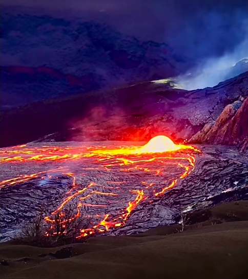
Five new vents have now opened on and near the northwest wall of Halemaʻumaʻu crater and produced small lava flows. Spattering continues from the north vent, periodic bursts from south and west vents. Summit inflation is stalled, tremor is increasing.
Overview:
A total of five new vents opened up on and near the base of the northwest wall of Halemaʻumaʻu crater since Monday night. These are all north of the established vent complex. Lava erupted from these fissures beginning with Vent 1 at 8:36 p.m. HST on September 14. The new flows are located just north of the established vent complex and erupted lava in the area of the small earthquake swarm on September 13 mentioned in the September 14 Kīlauea daily update. No significant fountaining was associated with the new vents, which continue to feed a small flow this morning in the northwest corner of the crater floor. Intermittent eruptions of spatter bursts continue to build a small cone around the north vent and sporadic spatter bursts were also observed from the south and west vents. No precursory lava flows have erupted from the main vent complex since September 12. The summit region continues to be highly pressurized, but it is not possible to forecast what might happen next. There are several possibilities outlined in the STATUS REPORT; the two most likely possibilities are the new vents erupting continuously or the new vents shutting down and returning all activity to the established vents.
No significant activity has been noted along Kīlauea’s East Rift Zone or Southwest Rift Zone.
Summit Observations:
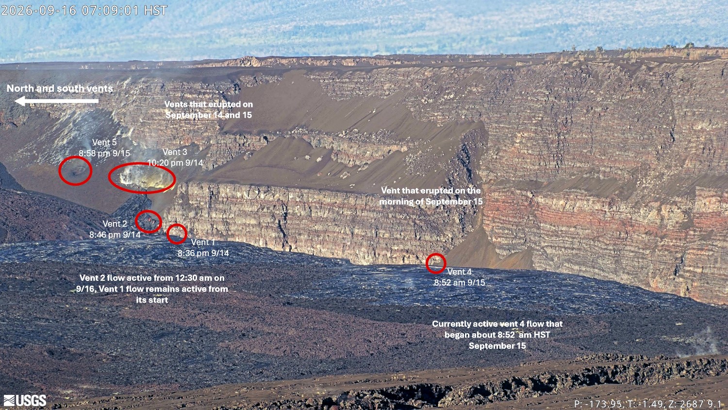
A total of five new vents have opened up on and near the base of the northwest wall of Halemaʻumaʻu crater since Monday night, September 14, north of the established vent complex. Three of the vents continue to feed active shelly pahoehoe flows on the floor of Halemaʻumaʻu crater this morning. The vents opened in the region of a small earthquake swarm on Sunday night reported in the September 14 Kīlauea update. No earthquakes immediately preceded the vent activity, which opened passively with little or no fountaining. The first vent began opening at 8:36 p.m. HST at the base of the crater wall. Initially it was just a small incandescent spot, but it began feeding a lava flow around 9:00 p.m. HST. The second vent opened up about 100 feet up the crater wall just to the south of the initial vent at 8:46 p.m. HST September 14 producing tiny flows that quickly stagnated. The third vent opened up about 200 feet higher in the middle of the tephra covered slope south of vent 1 and immediately fed a lava flow that reached the crater floor. The vent 3 flow appears to have stagnated quickly and was covered by vent 1 flows. The fourth vent opened at 8:52 a.m.
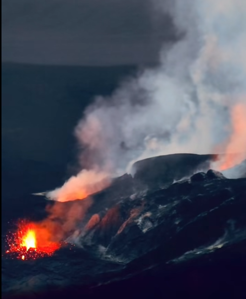
It immediately began feeding what became the largest flow during the day of September 15 though the vent 1 flow remained active. The fifth vent opened up at 8:58 p.m. HST south of the end of the vent 3 fissure on September 15. No lava flows emerged from this vent but successive bursts accompanied by flames and spatter occurred through the night until about 4 a.m. HST on September 16. These small explosive bursts excavated a small crater in the hillside overnight. Vent 2 reactivated at 12:30 a.m. HST this morning with a small dome fountain at the vent site feeding a small lava falls onto the crater floor. This flow quickly covered the vent 1 flows, but both appear to be active this morning as well as the vent 4 flows.
Intermittent spatter bursts and large flames continued from the north vent overnight but quieted down near dawn. Both the south and west vents continued to glow last night with occasional spatter bursts and flames from the south and west vents.
Precursory activity has now continued for about 9 days, which is now the longest period of precursory activity since high fountains began after episode 4, and has included 104 overflows. The next longest period of precursory activity was 6.2 days before episode 44. It is not clear that episode 55 high fountains will occur at this time, the various possibilities are outlined in the Kīlauea Status Report issued on Tuesday, September 15.
Seismic activity picked up yesterday in the summit region. Tremor recorded at Kīlauea’s summit has nearly doubled in the past 24 hours but that increase cannot be directly correlated with any of the changes in surface activity. Earthquakes also picked up last night with 12 earthquakes under the summit area in the last 24 hours. Nine of these earthquakes occurred within the past 8 hours scattered in a line from the north vent across Halemaʻumaʻu over to the Chain of Craters Road east of Kaluapele. None of these were clustered in time or space.
Summit inflation remains essentially stalled since the new vents opened on Monday night, September 14. Summit reinflation has been very unsteady since lava fountaining episode 54 on August 25. On September 7 around 3 p.m. HST, inflation at UWD reached a maximum that was higher than when episode 54 began, approximately 13.2 microradians. Following this inflationary high, UWD recorded around 1 microradian of deflation with the onset of precursory lava flows from the north vent. From then on, there was little net change until around 9 p.m. HST on September 10, when slow inflation returned. As of this morning, UWD is inflation remains stalled since stopping at about 9 p.m. HST. The total inflationary tilt measured on the UWD tiltmeter remains at 15.7 microradians, well above the 12.7 microradians lost during episode 54.
During inter-episode pauses, the sulfur dioxide (SO2) emission rate from the summit typically varies between 1,000 and 5,000 tonnes per day. Moderate to strong trade winds (10 miles per hour, 5 meters per second or more) are pushing the degassing plume to the southwest of Kīlauea’s summit caldera this morning and are expected to continue. Models indicate that gases as well as fine ash and Pele’s hair would be transported to the south of Kaluapele if episode 55 fountaining were to begin today.
Source : HVO.
Photos :USGS ( capture d’écran)
Iceland , Reykjanes Peninsula :
Situation on the Reykjanes Peninsula , Land uplift and magma accumulation continue
Updated 15 September 2026
Slow uplift continues at Svartsengi.
Seismic activity remains low.
The hazard assessment remains unchanged.
Deformation measurements continue to show uplift in the Svartsengi area. Over the past three months, the land has risen by approximately five centimetres.
The uplift indicates that pressure continues to build at a depth of several kilometres.
As long as uplift continues, the most likely scenario remains that a magma intrusion will propagate from Svartsengi into the Sundhnúkur crater row. This could lead to an eruption.
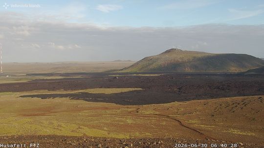
View of the eruption site from Húsafell, looking towards Þorbjörn.
It is not possible to predict when such an event might occur. As more time passes since the last event, uncertainty about the timing of the next event increases. A short lead time must still be expected, as was the case before previous eruptions along the Sundhnúkur crater row.
Seismic activity
Seismic activity along the Sundhnúkur crater row and near Grindavík remains low. However, there has recently been a slight increase in the number of small earthquakes, including within the magma intrusion. The depth of the earthquakes has changed little.
Hazard assessment
The hazard assessment remains unchanged and is valid until 30 September
Source et photo : IMO.
Indonesia , Ili Lewotolok :
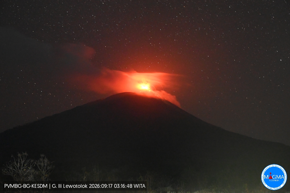
An eruption of Mount Ili Lewotolok occurred on Thursday, September 17, 2026, at 03:17 (WITA), with an ash column reaching a height of approximately 200 m above the summit (or about 1,623 m above sea level). The observed ash column was gray, of moderate intensity, and drifted towards the northwest. The eruption was recorded by the seismograph with a maximum amplitude of 40 mm and a duration of 48 seconds.
Seismic observations
216 eruption earthquakes, with amplitudes of 11.1–40 mm and durations of 23–127 seconds.
1 rockfall earthquake, with an amplitude of 16.6 mm and a duration of 30 seconds.
178 emission earthquakes, with amplitudes of 4.4–40 mm and durations of 21–61 seconds.
16 episodes of non-harmonic tremor, with amplitudes of 6.6–33.2 mm and durations of 86–347 seconds.
4 hybrid/multiphase earthquakes, with amplitudes of 6.6–11.1 mm and durations of 14–25 seconds.
1 shallow volcanic earthquake, with an amplitude of 40 mm and a duration of 11 seconds.
2 deep volcanic earthquakes, with amplitudes of 11.1–40 mm and durations of 9–15 seconds.
Recommendations
1. Communities living near Mount Ili Lewotolok, as well as visitors, climbers, and tourists, must not enter or conduct activities within a 2 km radius—extending to 3 km in the south and southeast sectors—of the Mount Ili Lewotolok activity center.
2. Remain vigilant regarding potential hazards associated with lava avalanches/rockfalls and pyroclastic flows in the south, southeast, west, and northeast sectors of Mount Ili Lewotolok.
Source et photo : PVMBG.
Colombia , Puracé – Los Coconucos volcanic chain :
Popayán, September 16, 2026, 2:00 PM
Based on monitoring of the Los Coconucos volcanic chain, the Colombian Geological Service (SGC), an agency attached to the Ministry of Mines, reports the following:
Since the publication of the last bulletin, recordings continue to show a predominance of seismic signals associated with fluid dynamics within the volcanic conduits, specifically long-period (LP) events and tremor (TR) pulses. These signals, associated with ash emissions, remain localized beneath the Puracé volcano crater at depths of less than 1 km. Seismicity linked to rock fracturing (volcano-tectonic, VT) has been located between 13 and 18 km northeast of the Puracé volcano, at depths ranging from 7 to 11 km. The maximum recorded magnitude was 1.8 ML.
Slow ground deformation continues in the area between the Puracé, Piocollo, and Curiquinga volcanoes. Regarding gas monitoring, sulfur dioxide (SO2) emissions persist, although a decrease in values has been observed. Conversely, the concentration of carbon dioxide (CO2) measured in the soil continues to rise.
Since the last bulletin, an ash emission was recorded; the ash dispersed toward the northwest of the volcanic edifice, following the wind direction. According to information published on satellite observation platforms, no thermal anomalies have been detected at the bottom of the crater.
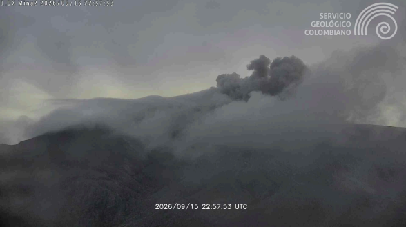
Figure 2. Recording from the Mina camera, located 2.2 km north of Puracé volcano, showing ash emission on September 15, 2026, at 17:57 (local time).
The public is advised not to approach the crater areas of the Puracé, Piocollo, and Curiquinga volcanoes, nor the headwaters of the rivers originating there, as sudden gas and ash emissions—accompanied by the ejection of rock fragments—may occur. Furthermore, the accumulation of ash and emitted material could trigger localized mudflows.
We also urge communities not to disseminate information regarding volcanic activity unless it originates from the Colombian Geological Service (SGC) or entities within the National Disaster Risk Management System.
In light of the above, the SGC recommends closely monitoring the evolution of this phenomenon via daily bulletins and other information published on our official channels, as well as adhering to instructions from local and departmental authorities and the National Unit for Disaster Risk Management (UNGRD).
The volcanic activity alert level remains at Orange: a volcano exhibiting significant changes in monitored parameters.
Source et photo : SGC.
Peru , Sabancaya :
Local date and time: September 14, 2026 – 13:43
Bulletin analysis period: September 7 to 13, 2026
Volcanic alert level
Orange alert level: The volcano is experiencing a significant increase in eruptive activity. Intensified seismic activity, frequent explosions, and the emission of ash and ballistic blocks are being observed.
Conclusions
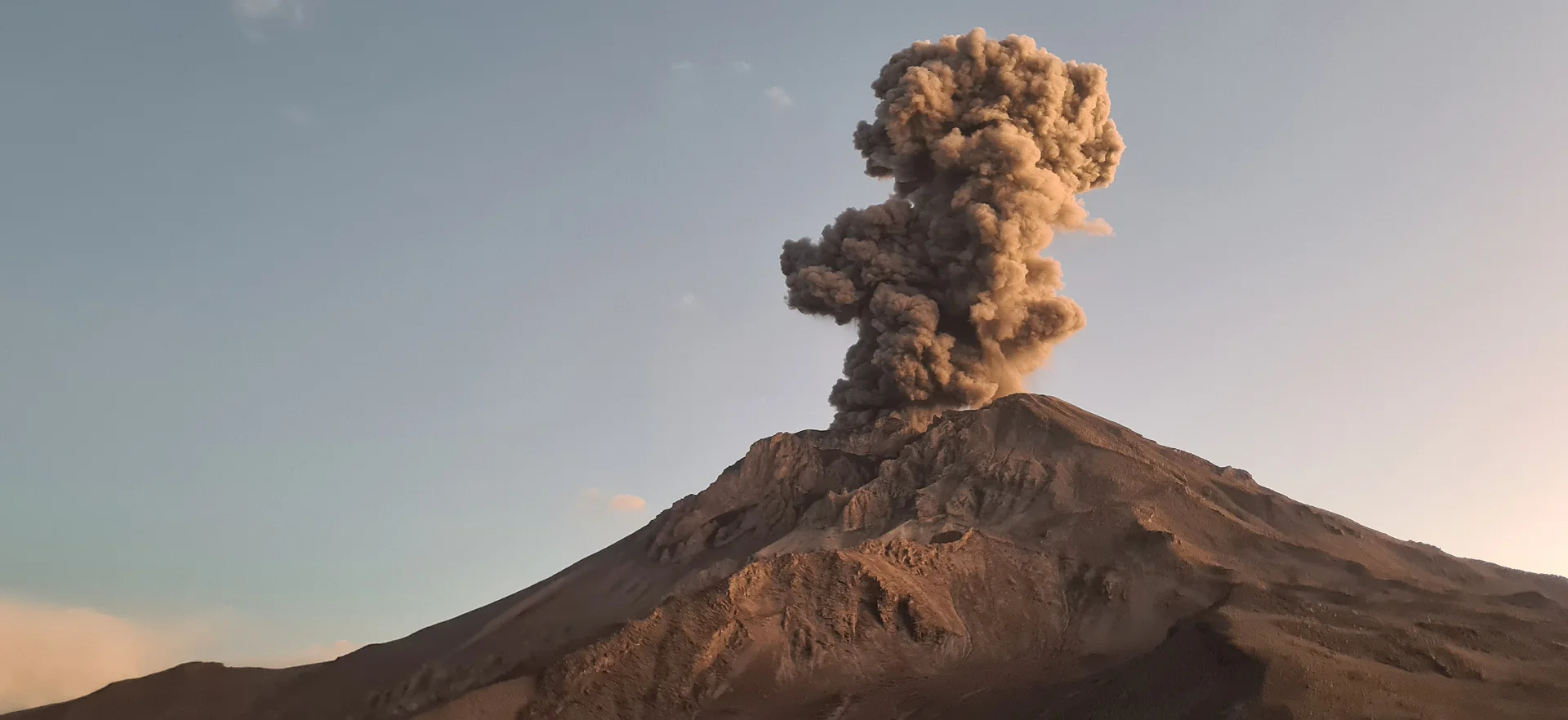
The IGP reports that the eruptive process at Sabancaya volcano is ongoing. During this period, no volcanic explosions were recorded; only emissions of water vapor, ash, and gas reaching up to 500 m above the summit were observed, accompanied by seismic activity linked to the movement of magmatic fluids and internal fracturing processes. Consequently, the volcanic alert level remains at orange.
Recommendations
Stay continuously informed about Sabancaya’s volcanic activity through reports and bulletins published by the IGP.
Outlook
Future volcanic explosions generating eruption columns exceeding 2 km in height are considered probable. Such events could affect districts in the Colca Valley and surrounding areas through the dispersal of volcanic ash; the volcanic alert level therefore remains at orange.
Source et photo : IGP.