March 22 , 2026.
La Réunion Island , Piton de la Fournaise :
Press release from the Paris Institute of Earth Physics / Piton de la Fournaise Volcanological Observatory, March 22, 2026 – 7:45 a.m. local time – 3:45 a.m. UTC
Eruption in progress
The eruption that began on February 13, 2026, shortly after 10:00 a.m. (local time) at Piton de la Fournaise continues.
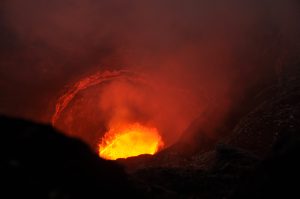
Only one eruptive site remains active on the south-southeast flank of the volcano at an altitude of 2,056 meters, with a cone formed by the accumulation of ejected material. The lava fountains at the eruptive site are still very active, with ejections reaching about ten meters above the cone, visible from Piton de Bert.
The lava field emitted from the eruptive site forms two main arms, each branching into secondary arms. Over the past 24 hours, only the southern main arm has been active. The fronts of the two northern arms remained stable, situated at approximately 660 meters altitude for the main northern arm and 690 meters for the secondary northern arm.
The southern arm, after splitting into several secondary arms, crossed the RN2 highway on March 13th and reached the ocean on March 16th.
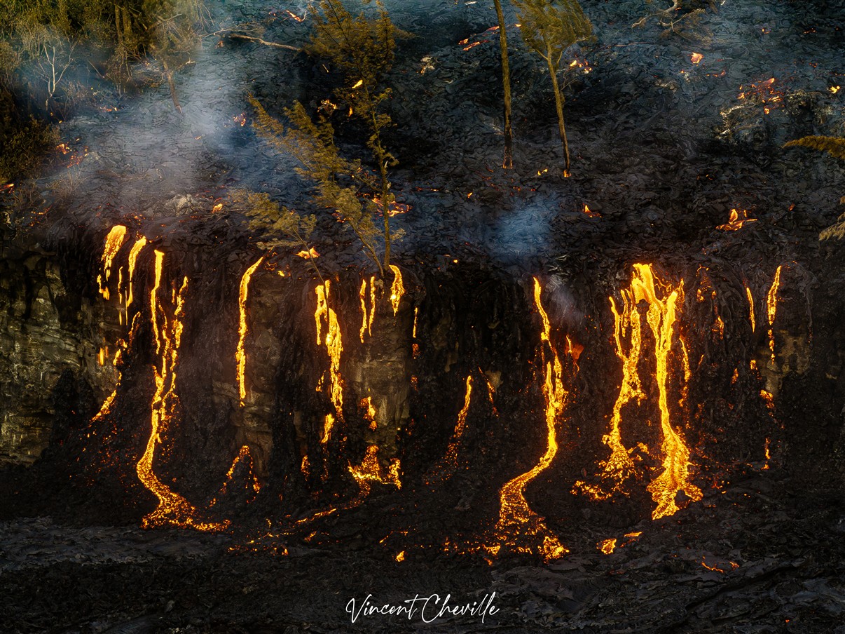
Several secondary channels also formed downstream of the RN2 highway before the lava flow reached the ocean.
At the point of contact between the lava and the ocean, a platform continues to build and widen, resulting from the accumulation of lava flow and fine particles from lava fragmentation. Over the past 24 hours, the lava supply to the platform has been lower, and numerous lava tubes have developed there.
At this point of contact with the ocean, a gas plume is still present. This plume is mainly composed of water vapor, hydrochloric acid (HCl), and fine particles. When the lava, at a temperature of approximately 1130°C, comes into contact with the sodium chloride-rich ocean water, it generates an acidic aerosol in the form of fine suspended droplets. This plume also contains particles of pulverized lava and fragments of volcanic glass, which can be transported over several hundred meters to kilometers by the wind.
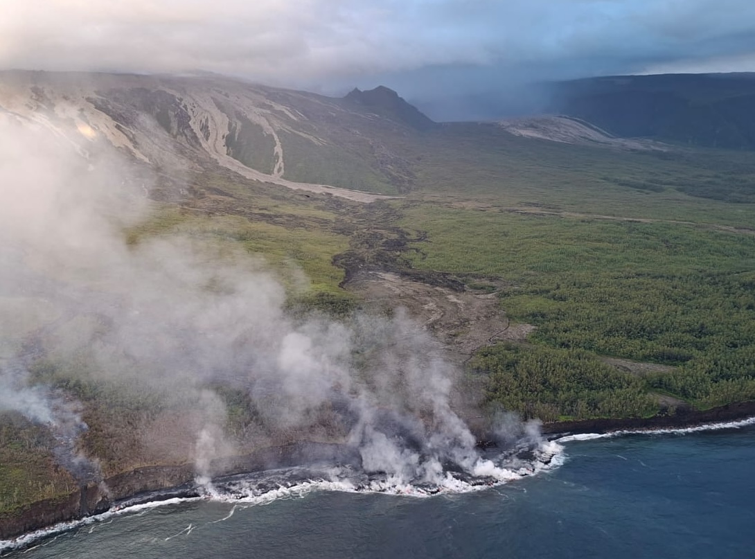
This plume, sometimes called « lava haze, » can be irritating and corrosive to the respiratory system, skin, and eyes. Its dispersion is closely linked to local weather conditions. Furthermore, the sudden contact between lava and water can generate localized explosions, projecting molten material and jets of high-temperature steam in the immediate vicinity of the point of entry into the sea. Explosions could also occur if the platform becomes destabilized. Indeed, this platform, composed of an accumulation of lava flows and rock fragments, remains highly unstable and fragile. In the event of sudden destabilization, explosions of varying intensity could occur.
Seismic activity continues to rise, with more than 225 volcano-tectonic earthquakes detected on March 21. These earthquakes are located above the shallow reservoir (situated at a depth of approximately 1.5 to 2 km below the summit) and mostly beneath the southeastern rim of the Dolomieu crater.
Deflation of the summit area continues. The shortening of the baselines crossing the summit reveals a contraction of the summit area. This deflation suggests a depressurization of the shallow magma reservoir.
Between March 14 and 20, a significant increase in eruptive tremor was observed, accompanied by intermittent « gas piston » phases. These signals indicate pulsed degassing in the conduit, linked to the ascent of gas pockets through the magma approximately every 5 to 10 minutes. The last sequence of this type ceased on March 20 around 7:30 UTC (11:30 local time), and since then, a decrease in the tremor amplitude has been observed.
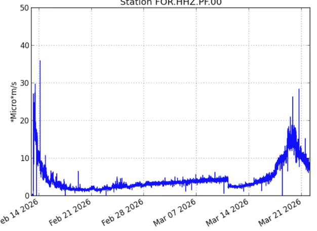
Evolution of tremor amplitude (an indicator of lava and gas emissions at the surface) between February 13 and March 22, 2026, at the FOR seismological station located near the eruption (©WebObs/OVPF-IPGP)
The intensification of tremor has been correlated with an increase in SO₂ fluxes measured by satellite (TROPOMI) and by the OVPF’s NOVAC ground-based network since March 15, suggesting an increase in degassing activity. Over the last 24 hours, the SO₂ flux has decreased but remains high (3.5 kton/day). Since March 18, an increase in estimated flow rates, based on satellite data (HOTVOLC, OPGC-Université Clermont Auvergne and MIROVA, University of Turin), has also been observed, with peak values exceeding 30 m³/s reached on March 20 and peak values of 23 m³/s over the last 24 hours. It should be noted that these values may be underestimated due to observational biases, particularly those related to meteorological conditions (cloud cover), the development of lava tube flows, and the lava flow entering the sea, which limit the detection of thermal radiation.
Alert Level 2.2
Source : OVPF / IPGP.
Photos : Vincent Cheville / Vincent Tunneldelave Réunion / FB , ULM Papangue / OVPF , OVPF.
Philippines , Bulusan :
BULUSAN VOLCANO BULLETIN , 22 March 2026 , 12:00 PM
Notice for raising the alert status of Bulusan Volcano from Alert Level 0 (Normal) to Alert Level 1 (Low-level Unrest).
Bulusan Volcano entered a period of low-level unrest with a sustained series of volcanic earthquakes that began on 15 March 2026. Since then, a total of four hundred seventy-five (475) volcanic earthquakes has been recorded by the Bulusan Volcano Network (BVN). Most of these were weak volcano-tectonic earthquakes that are associated with rock fracturing at shallow depths beneath the volcano edifice and are similar in general characteristics to seismicity prior to the June 2022 and April 2025 eruptions. In addition to this, ground deformation data from continuous GPS and electronic tilt monitoring indicate inflation or swelling of the western and southeastern flank since the last week of January and first week of March 2026, respectively. Degassing activity from the active vents when visible has been weak to moderate, consistent with weak volcanic sulfur dioxide or SO2 emission as indicated by below background averages of 91 tonnes/day measured on 17 March 2026. Overall, these parameters could indicate that shallow hydrothermal processes beneath the volcano are underway that could lead to steam-driven or phreatic eruptions at any of its summit vents.
In view of the above, DOST-PHIVOLCS is now raising the alert status of Bulusan from Alert Level 0 to Alert Level 1, which means that the volcano is currently in a state of low-level unrest with increased chances of phreatic eruptions. Local government units and the public are hereby reminded that entry into the 4-kilometer radius Permanent Danger Zone (PDZ) should be strictly prohibited and that vigilance in the 2-kilometer Extended Danger Zone (EDZ) on the southeast sector should be exercised due to the possible impacts of volcanic hazards such as pyroclastic density currents or PDCs, ballistic projectiles, rockfall, avalanches and ashfall on these danger areas. Communities west of the volcano are also advised to prepare for ashfall in case phreatic eruption occurs, paying special attention to vulnerable members of the community including the elderly, expecting mothers, infants and those with medical conditions. Civil aviation authorities must also advise pilots to avoid flying close to the volcano’s summit as ash from any sudden phreatic eruption can be hazardous to aircraft. Furthermore, people living within valleys and along river/stream channels especially on the southeast, southwest and northwest sector of the edifice should be vigilant against sediment-laden stream flows and lahars in the event of heavy and prolonged rainfall should phreatic eruption occur.
DOST-PHIVOLCS is closely monitoring Bulusan Volcano’s condition and any new development will be relayed to all concerned.
Source et photo : DOST-PHIVOLCS.
Indonesia , Guntur :
Increased number of deep volcanic earthquakes at Guntur volcano, West Java.
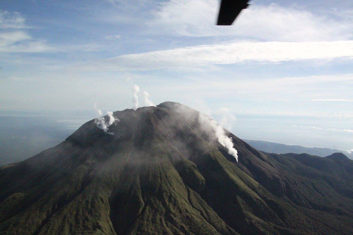
Guntur volcano is an andesitic volcanic complex composed of old and young cones. The old cones are Kamojang, Kancing, Gandapura, Gajah, Agung, Picung, and Pasir Malang. The young cones include Masigit (the highest peak, reaching 2,249 m), Paruhpuyan, Kabuyutan, and Guntur, which form a northwest/southeast alignment.
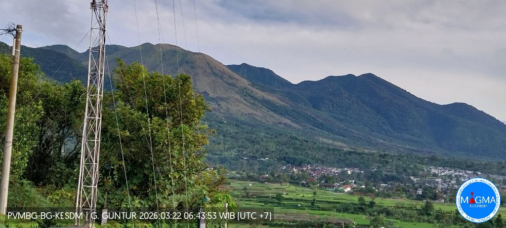
Guntur volcano activity is monitored from the Guntur observation post, located in Sirna Jaya village, Garut Regency, West Java. On March 21, 2026, at 8:00 AM Western Indonesian Time (WIB), 11 deep volcanic earthquakes were recorded. No smoke was observed at the crater. The seismicity of Mount Guntur is generally dominated by distant tectonic earthquakes (TJ). Between March 1 and 20, 2026, one shallow volcanic earthquake (VB), 79 deep volcanic earthquakes (VA), 21 local tectonic earthquakes (TL), one earthquake felt on the I/MMI scale, and 36 distant tectonic earthquakes (TJ) were recorded. The number of deep volcanic earthquakes increased on March 18 and 19 (17 events each). On March 20, 26 deep volcanic earthquakes, four local tectonic earthquakes, and four distant tectonic earthquakes were recorded.
The distribution of the hypocenters of deep volcanic earthquakes in March 2026 appears to be concentrated at depths of 2.5 to 6.5 km below the summit. The epicenters are oriented northwest/southeast. This direction corresponds to the dominant structure or alignment of the region. The occurrence of deep volcanic earthquakes indicates the migration or movement of magma from deep magma chambers to shallower areas.
The activity level of Mount Guntur is currently at level I (normal).
Source et photo : PVMBG.
Ecuador , Sangay :
DAILY REPORT ON THE STATE OF SANGAY VOLCANO, Saturday, March 21, 2026.
Geophysical Information Institute – EPN.
Surface Activity Level: High, Surface Trend: No Change
Internal Activity Level: Moderate, Internal Trend: No Change
Seismicity: From March 20, 2026, 11:00 AM to March 21, 2026, 11:00 AM:
Seismicity:
Explosions (EXP): 143
Precipitation/Lahars:
No precipitation has been recorded in the volcano area. **Heavy rainfall could remobilize accumulated material, generating mudflows and debris flows that would cascade down the volcano’s flanks and into nearby rivers.
Emission/Ash Column:
Since yesterday afternoon, several gas and ash emissions have been observed by the monitoring camera system. These emissions reached a height of between 300 and 500 meters above the crater and moved toward the northeast and east. The Washington VAAC agency also issued two reports of gas and ash plumes reaching 900 meters above the crater and moving eastward.
Other Monitoring Parameters:
Over the past 24 hours, the FIRMS satellite system recorded eight thermal anomalies, the MIROVA-MODIS system one, the MIROVA-VIIRS 375 system two, and the MIROVA-VIIRS 750 system two.
Observation:
During the night, monitoring cameras observed incandescent material cascading down the volcano’s flanks to a distance of 1,400 meters below the crater.
At the time of writing, the volcano remains partially exposed.
Alert level: Yellow
Source : IGEPN
Photo : Eqphos_fotografía
Hawaii , Kilauea :
HAWAIIAN VOLCANO OBSERVATORY DAILY UPDATE , U.S. Geological Survey
Saturday, March 21, 2026, 9:03 AM HST (Saturday, March 21, 2026, 19:03 UTC)
19°25’16 » N 155°17’13 » W,
Summit Elevation 4091 ft (1247 m)
Current Volcano Alert Level: WATCH
Current Aviation Color Code: ORANGE
Activity Summary:
The Halemaʻumaʻu eruption of Kīlauea is paused. The summit is currently inflating slowly, occasional glow was visible from the south vent and gas-pistoning continues. The preliminary forecast window for the onset of episode 44 lava fountaining is April 1 to April 10.
No significant activity has been noted along Kīlauea’s East Rift Zone or Southwest Rift Zone.
Power outages and storm effects continue to hamper our monitoring network. Another storm is expected over the weekend and we expect issues to continue until it clears and power stabilizes on the island.
NOTE: The V2 camera went offline due to a power outage, the V1 camera remains damaged from episode 43.

Summit Observations:
Overnight, intermittent glow was observed at the south vent via the V3 webcam. Currently, both vents are quiet and emitting gas plumes, while abundant steam rises from cooling lava flows from episode 43 within Halemaʻumaʻu crater.
Seismic tremor has decreased overall, though tremor bursts persist at intervals of 5–10 minutes. These bursts correlate with peak temperatures recorded by the F1 thermal camera at the south vent, consistent with ongoing gas pistoning within the vent. No earthquakes were recorded at the summit during the past day.
Summit tiltmeters UWD, SDH, and SMC continue to record slow inflation tha past few days. UWD is currently offline but is estimated to have gained approximately 12 microradians of tilt since the end of episode 43.
During eruptive pauses, like the current conditions, the SO2 emission rate from the summit has varied within a typical range of 1,000 to 5,000 tonnes of SO2 per day.
Rift Zone Observations:
Rates of seismicity and ground deformation remain very low in the East Rift Zone and Southwest Rift Zone. SO2 emissions from the East Rift Zone remain below the detection limit.
Source et photo : HVO.