March 19 , 2026.
La Réunion Island , Piton de la Fournaise :
Press release from the Paris Institute of Earth Physics / Piton de la Fournaise Volcanological Observatory, March 19, 2026 – 6:45 a.m. local time – 2:45 a.m. UTC
Eruption in progress
The eruption that began on February 13, 2026, shortly after 10:00 a.m. (local time) at Piton de la Fournaise continues.
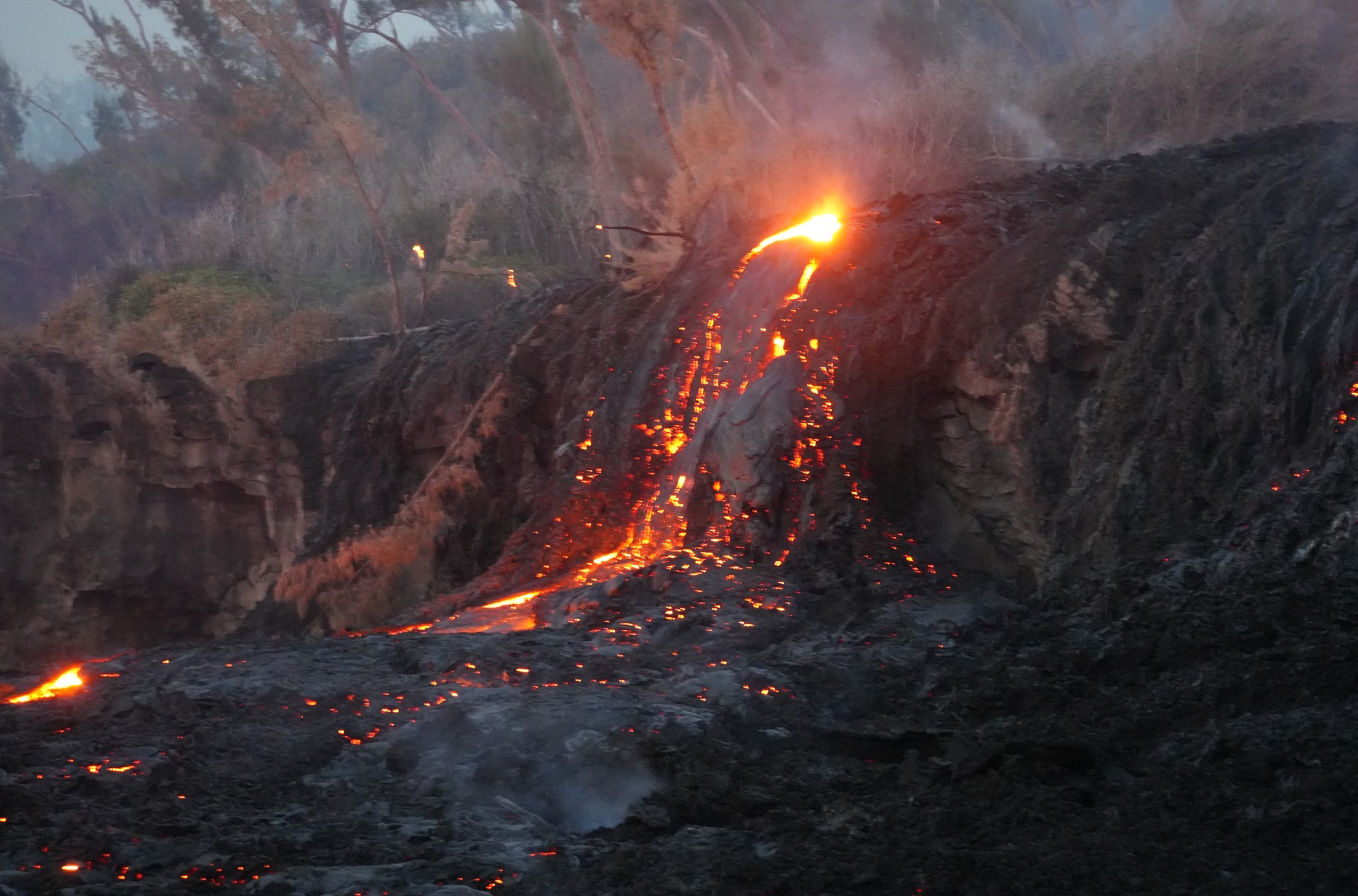
Only one eruptive site remains active on the south-southeast flank of the volcano at an altitude of 2,056 m, visible from Piton de Bert. The eruptive cone is now well-formed and continues to close progressively. Few ejecta now exceed the height of the cone.
With the lateral closure of the cone, significant lava tube activity is now established.
The lava field emitted from the eruptive site still forms two main arms. The front of the northern arm remains stationary approximately 2.6 km from National Route 2 (RN2), at an altitude of about 660 m. However, since yesterday, the northern arm has been fed again, and activity is visible in its upstream section (upper Grandes Pentes).
The southern arm, after splitting into several secondary branches, crossed National Route 2 (RN2) on March 13th and reached the ocean on March 16th at around 12:20 AM local time. Upstream of the road, several resurgences and secondary flow channels are visible on the south side, but their progress is currently very slow and does not pose any threat to RN2 at this time.
Several secondary channels also formed downstream of RN2 before the flow reached the ocean.
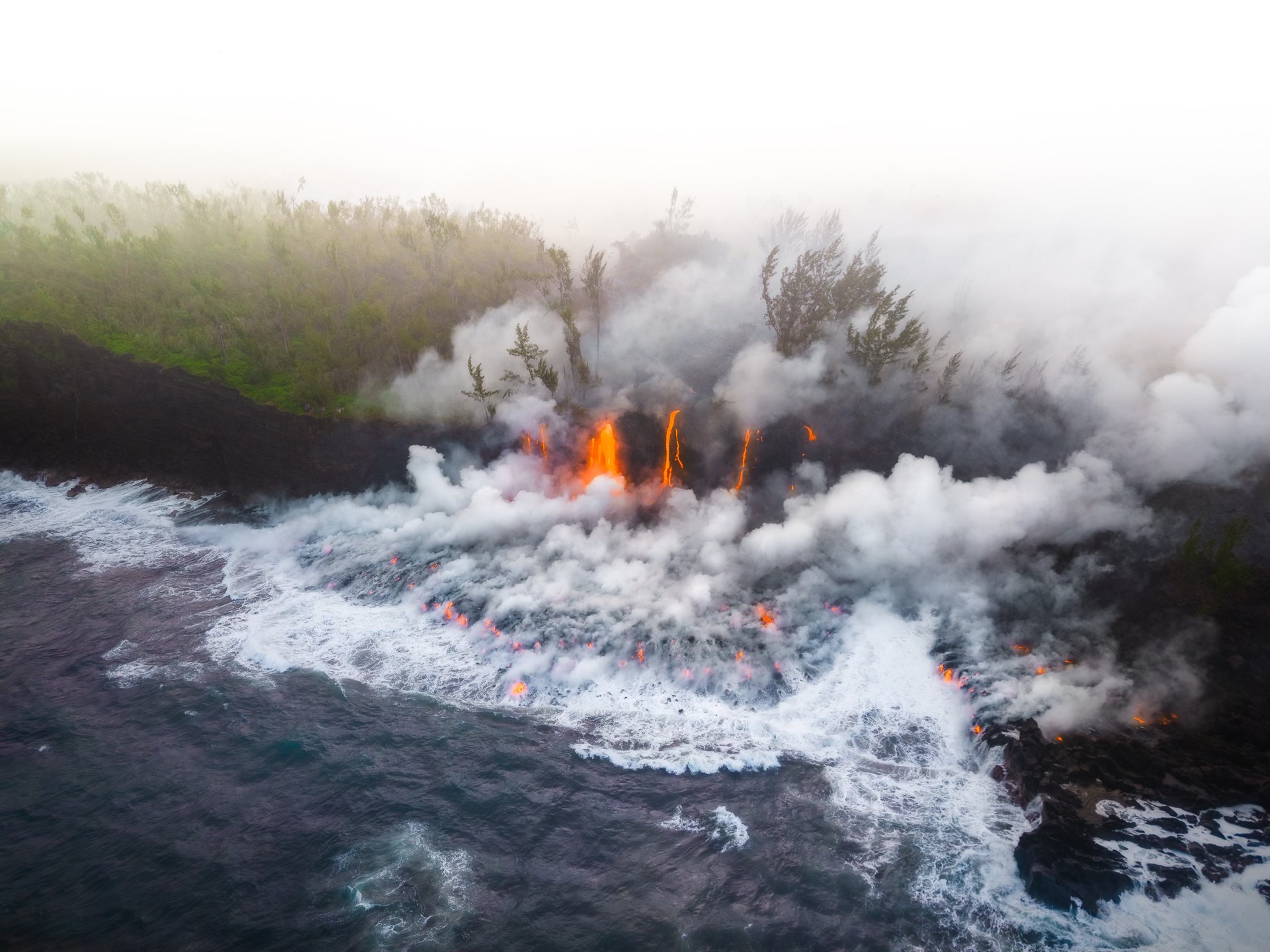
At the point of contact between the lava and the ocean, a platform continues to form and expand, resulting from the accumulation of lava flow and fine particles from lava fragmentation. Yesterday at noon (local time), at the point of impact, the platform had advanced 85 meters into the ocean.
At this point of entry into the ocean, a plume is developing. This plume is primarily composed of water vapor, hydrochloric acid (HCl), and fine particles. When the lava, at a temperature of approximately 1130°C, comes into contact with the ocean water, which is rich in sodium chloride, it generates an acidic aerosol in the form of fine droplets.
This plume also contains particles of pulverized lava and fragments of volcanic glass, which can be transported over several hundred meters to kilometers by the wind.
This plume, sometimes called « lava haze, » can be irritating and corrosive to the respiratory tract, skin, and eyes. Its dispersal is highly dependent on local weather conditions. Furthermore, the sudden contact between the lava and the water can generate localized explosions, projecting molten material and jets of high-temperature steam in the immediate vicinity of the point of entry into the sea.
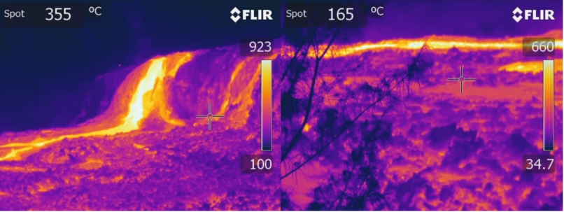
Thermal imaging of the lava platform forming at the point of contact between the lava and the ocean on March 18, 2026, at 10:53 a.m. local time (©OVPF-IPGP)
Explosions could also occur if the platform becomes destabilized. This platform, composed of an accumulation of lava flows and rock fragments, remains highly unstable and fragile. In the event of sudden destabilization, explosions of varying intensity could occur. Furthermore, depending on the evolution of volcanic activity, lava flows could also develop within the platform. On its hardened surfaces, the temperature remains high, exceeding 150°C.
Seismic activity has been recorded again beneath the summit area, with a particularly sharp increase over the last 5 hours. Between midnight local time on March 18 and 6:00 a.m. local time on March 19, 53 shallow volcano-tectonic earthquakes were recorded.
Deflation of the summit zone appears to be beginning. For several days, the baselines crossing the summit showed stabilization; now, a decrease in these baselines is being recorded, indicating a contraction of the summit zone. The initiation of deflation suggests a depressurization of the shallow magma reservoir. This deflation will need to be confirmed with measurements taken in the coming days.
Since March 14, a significant increase in eruptive tremor has been observed, accompanied by intermittent « gas piston » phases. These signals indicate pulsating degassing within the conduit, linked to the ascent of gas pockets through the magma. Over the past 24 hours, these gas piston phases have themselves appeared intermittent, with sequences of pauses and resumptions. The most recent gas piston phase occurred on March 17 between 12:00 and 18:00 UTC.
The intensification of the tremor is correlated with an increase in SO₂ fluxes measured by satellite (TROPOMI) and by the OVPF’s NOVAC ground-based network since March 15, suggesting an increase in degassing activity.
Since yesterday, March 18, an increase in flow rates from satellite data (HOTVOLC, OPGC-Université Clermont Auvergne and MIROVA, University of Turin) has also been observed, with peak values reaching 16 m³/s.
It should be noted that these values may be underestimated due to observational biases, particularly those related to meteorological conditions (cloud cover), the development of lava tube flows, and the lava flow entering the sea, which limit the detection of thermal radiation.
The fact that the increase in tremor appears more pronounced than that of surface lava flow rates can be explained by several factors. Firstly, tremor, which reflects both magma flow and surface degassing, can be amplified by the progressive construction of the eruptive cone, altering the flow and degassing conditions near the vent. On the other hand, uncertainties affecting satellite estimates can mask actual variations in flow rate. Finally, partial gas-magma decoupling in the conduit is also possible: in this case, an increase in degassing—the main contributor to tremor according to several recent studies at Piton de la Fournaise—could occur without a significant change in the lava flow rate estimated by thermal methods.
Alert Level 2.2
Source : OVPF / IPGP.
Photos : Zamir Popat Photographies / FB , OVPF .
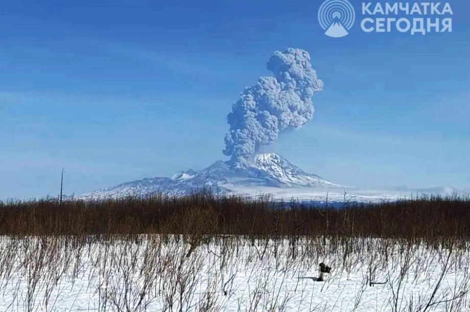
Kamchatka , Sheveluch :
KVERT VOLCANIC ACTIVITY NOTICE (VAN)
Issued: March 19 , 20260319/0515Z
Volcano: Sheveluch (CAVW #300270)
Current aviation colour code: RED
Previous aviation colour code: orange
Source: KVERT
Notice Number: 2026-27
Volcano Location: N 56 deg 38 min E 161 deg 19 min
Area: Kamchatka, Russia
Summit Elevation: 3283 m (10768.24 ft), the dome elevation ~2500 m (8200 ft)
Volcanic Activity Summary:
An explosive-extrusive eruption of the volcano continues, accompanied by powerful gas-steam activity; a new block of lava continues to grow in the northern part of the lava dome. Satellite data showed explosions sent ash up to 11.5 km a.s.l., and ash cloud extended to the north-east of the volcano.
An explosive-extrusive eruption of the volcano continues. Ash explosions up to 12 km (39,400 ft) a.s.l. could occur at any time. Ongoing activity could affect international and low-flying aircraft.
Volcanic cloud height:
11500 m (37720 ft) AMSL Time and method of ash plume/cloud height determination: 20260319/0310Z – Himawari-9 14m15
Other volcanic cloud information:
Distance of ash plume/cloud of the volcano: 140 km (87 mi)
Direction of drift of ash plume/cloud of the volcano: NE / azimuth 49 deg
Time and method of ash plume/cloud determination: 20260319/0430Z – Himawari-9 14m15
Start time of explosion and how determined: 20260319/0300Z – Satellite data
Duration of explosion: ~ 20 min
Source : Kvert.
Photo : ИА Камчатка
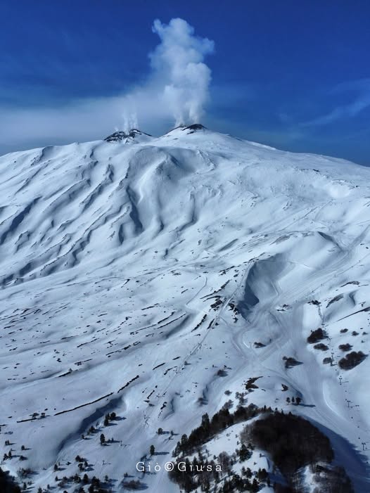
Italy / Sicily , Etna :
Etna Activity Update, March 19, 2026, 05:47 (04:47 UTC).
The National Institute of Geophysics and Volcanology, Etna Observatory, reports that no volcanic activity is observed in the images from the monitoring cameras.
The average amplitude of the volcanic tremor, which began around 02:00 (UTC), showed an upward trend and reached high values at 03:50 (UTC).
Currently, the location of the center of gravity of the volcanic tremor sources is uncertain. No changes have been recorded in recent hours, either in the frequency of occurrence of the infrasonic activity or in its location, which is situated below the Voragine crater.
Analysis of ground deformation measurement network data reveals the onset of decompression at 03:55 UTC at the DRUV inclinometer, as well as a possible signal at the summit ECPN inclinometer. These variations remain very small, insufficient to distinguish them from normal signal fluctuations.
The GNSS network is not detecting any significant deformation.
Further updates will be provided soon.
Source : INGV.
Photo : Gio Giusa .
Indonesia , Lewotobi Laki-Laki :
An eruption of Mount Lewotobi Laki-laki occurred on Thursday, March 19, 2026, at 2:36 PM WITA. The observed ash column rose approximately 1,000 meters above the summit (approximately 2,584 meters above sea level). This ash column was gray and very dense, oriented to the north and northeast. The eruption was recorded by a seismograph, with a maximum amplitude of 14.8 mm and a duration of 130 seconds.

VOLCANO OBSERVATORY NOTICE FOR AVIATION – VONA
Issued : March 19 , 2026
Volcano : Lewotobi Laki-laki (264180)
Current Aviation Colour Code : ORANGE
Previous Aviation Colour Code : orange
Source : Lewotobi Laki-laki Volcano Observatory
Notice Number : 2026LWK023
Volcano Location : S 08 deg 32 min 20 sec E 122 deg 46 min 06 sec
Area : East Nusa Tenggara, Indonesia
Summit Elevation : 5069 FT (1584 M)
Volcanic Activity Summary :
Eruption with volcanic ash cloud at 06h36 UTC (14h36 local).
Volcanic Cloud Height :
Best estimate of ash-cloud top is around 8269 FT (2584 M) above sea level or 3200 FT (1000 M) above summit. May be higher than what can be observed clearly. Source of height data: ground observer.
Other Volcanic Cloud Information :
Ash cloud moving from north to northeast. Volcanic ash is observed to be gray. The intensity of volcanic ash is observed to be thick.
Remarks :
Eruption recorded on seismogram with maximum amplitude 14.8 mm and maximum duration 130 second.
Source et photo : PVMBG.
Colombia , Chiles / Cerro Negro :
San Juan de Pasto, March 17, 2026, 8:35 PM
Regarding the monitoring of activity at the Chiles-Cerro Negro Volcanic Complex (CVCCN), the Colombian Geological Survey (SGC), an agency under the Ministry of Mines and Energy, reports the following:
During the period from March 10 to 16, 2026, the main variations in monitored parameters compared to the previous week were as follows:
● Consistent with the fluctuating behavior characteristic of the volcanic complex, a slight increase in the daily frequency and a decrease in the released seismic energy were recorded. Seismicity related to rock fracturing remained predominant, followed by seismicity associated with fluid dynamics. Most of the earthquakes occurred south and southwest of the summit of Chiles volcano, in an area approximately 3 km in diameter, at depths between 0.7 and 8 km below the summit (4,700 m altitude) and with magnitudes less than 1.9.

Analysis of data from satellite sensors and ground stations continues to reveal variations related to deformation processes in certain sectors of the volcanic zone.
Based on the assessment and correlation of monitored parameters, the Geological Survey of Colombia (SGC) recommends closely monitoring the evolving situation through weekly bulletins and other information published via its official channels, as well as following the instructions of local and departmental authorities and the National Unit for Disaster Risk Management (UNGRD).
Volcanic activity remains at the yellow alert level: Active volcano with changes in the baseline behavior of monitored parameters and other manifestations.
Source et photo : SGC.