March 16 , 2026.
La Réunion Island , Piton de la Fournaise :
Press release from the Paris Institute of Earth Physics / Piton de la Fournaise Volcanological Observatory, March 16, 2026 – 5:30 a.m. local time – 5:30 a.m. UTC
Eruption in progress
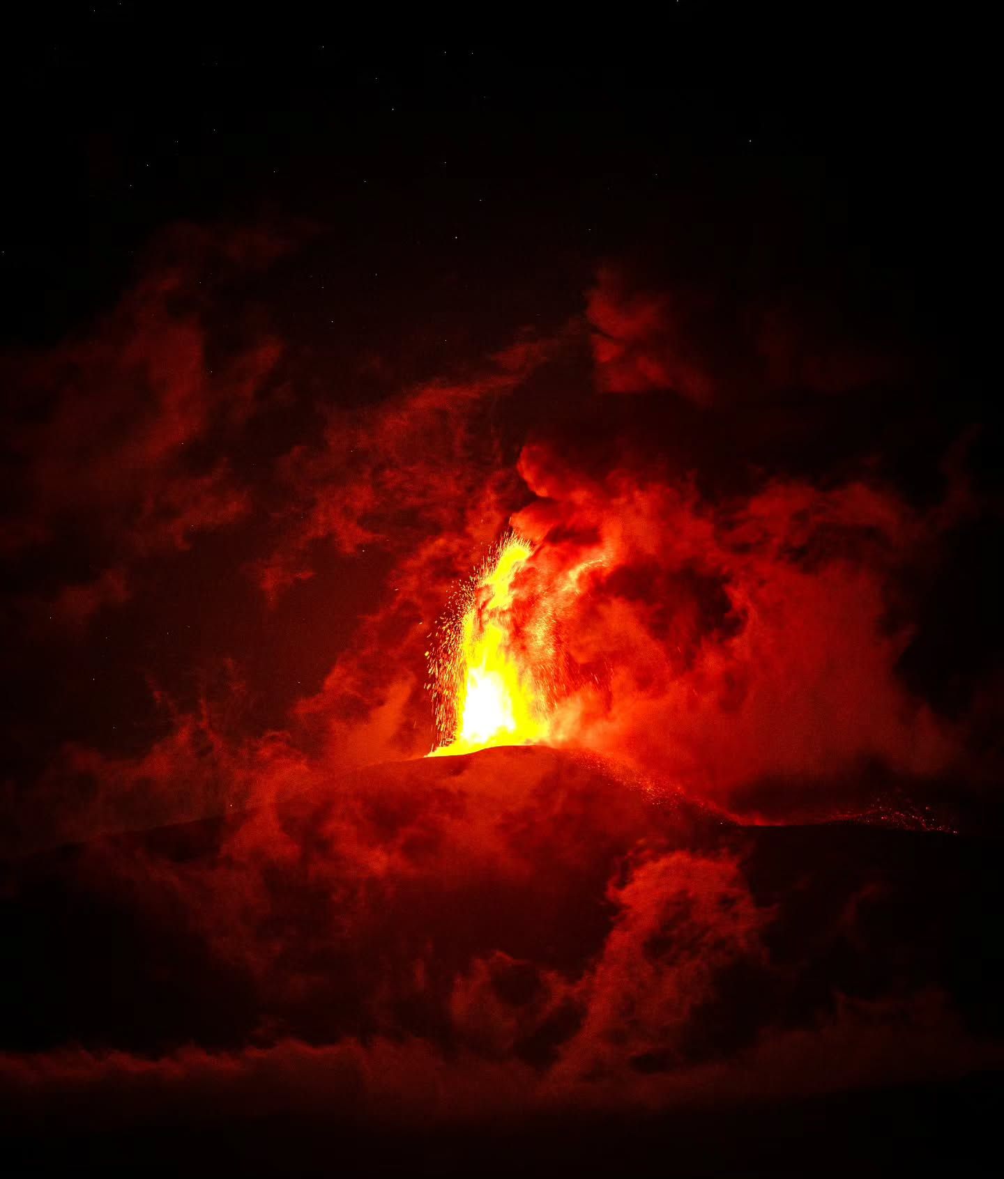
The eruption that began on February 13, 2026, shortly after 10:00 a.m. (local time) at Piton de la Fournaise continues.
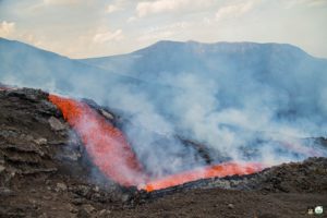
Only one eruptive site remains active on the south-south-southwest flank of the volcano, visible from Piton de Bert. The eruptive cone is now well-formed and continues to close progressively. Few ejecta now exceed the height of the cone.
With the lateral closure of the cone, significant lava tube activity is now established. Since March 3, lava flows have been visible again in the Grandes Pentes area.
The lava field emitted from the eruptive site still forms two main arms. The northern arm of the lava flow remains stationary approximately 2.6 km from National Route 2 (RN2), at an altitude of about 660 m.
The southern arm has split into several secondary arms, which continue their advance at highly variable speeds, influenced by factors such as the topography and vegetation encountered along their path, which can locally slow or channel the lava flow.
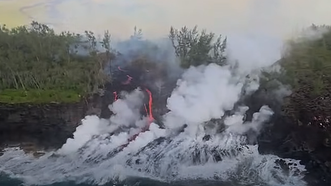
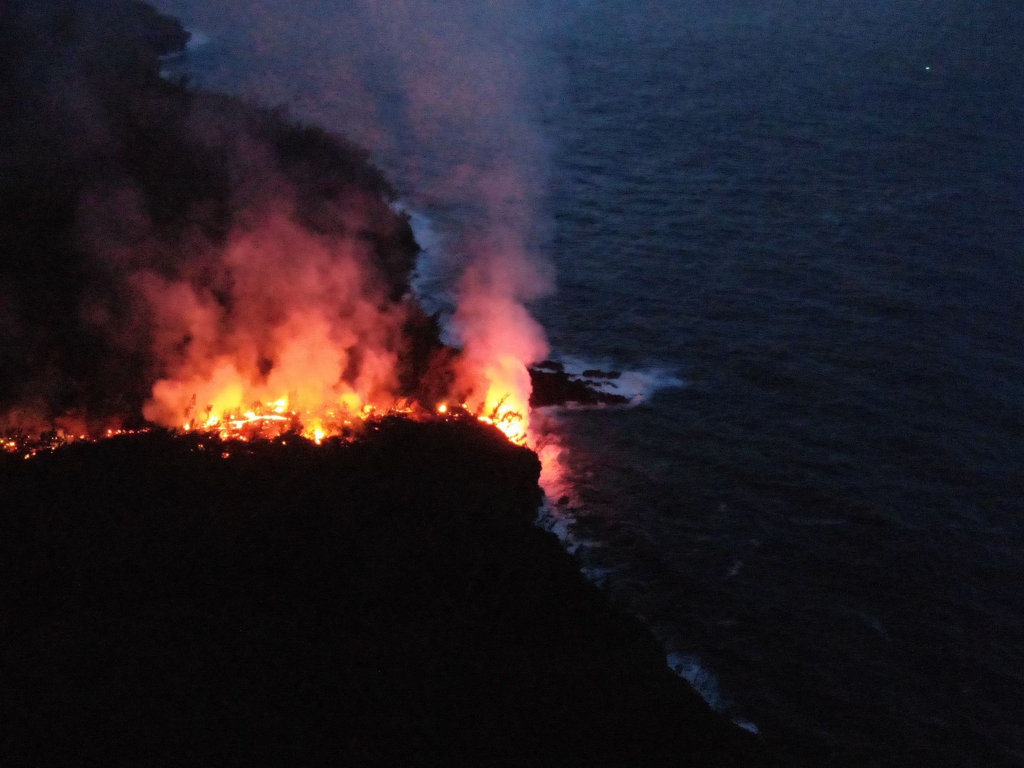
After crossing National Route 2 (RN2) on March 13, the lava reached the ocean on March 16 at approximately 12:20 a.m. local time.
Upstream of the road, several resurgences and new secondary flow channels have been observed on the south side. The closest to the road was located approximately 2.1 km from the RN2 last night. These flows are being monitored to assess their progression and potential impacts on the RN2.
As in previous days, seismic activity remains low. The inflation of the edifice, visible particularly on the summit GNSS stations and at the base of the terminal cone, continues, although it has slowed. Since the end of February, the baselines crossing the summit have been showing an increase in distance, indicating a gradual re-expansion of the edifice.
This inflation indicates a repressurization of the magmatic supply system, possibly linked to a recharge of magma from the shallow reservoir.
Following an increase in eruptive tremor on March 14th at approximately 3:15 PM UTC, the volcanological observatory’s stations recorded episodes of gas piston tremor (intermittent tremor). This observation reflects pulsed degassing within the eruptive conduit, linked to the ascent of gas pockets through the magma column. These gas pockets periodically push magma towards the surface, causing variations in tremor intensity and intermittent explosive bursts at the vent.
At Piton de la Fournaise, this phenomenon is often observed when the magma’s gas content decreases, making degassing more intermittent. However, the arrival of a new batch of magma richer in gas remains possible, which could lead to an increase in degassing and eruptive activity.
Surface flow rates, estimated from satellite data via the HOTVOLC platform (OPGC – Clermont Auvergne University), have been below 5 m³/s over the past 24 hours. It should be noted that these estimates can vary significantly depending on cloud cover and become zero in the event of total cloud cover.
Current lava tube activity also tends to underestimate the flow rates observed by satellite methods.
Alert Level 2.2
Source : OVPF / IPGP.
Photos : OVPF .
Philippines , Kanlaon :
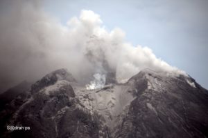
Another moderately explosive eruption occurred at the summit of Kanlaon Volcano at 06:07 PM today, generating a 5 kilometer-high eruption column that is drifting to the southeast and northeast. This is the third event at Kanlaon this year, following similar eruptions in 19 and 26 February 2026. Alert Level 2 is maintained over Kanlaon Volcano and entry into the 4 kilometer PDZ (Permanent Danger Zone) must be prohibited.
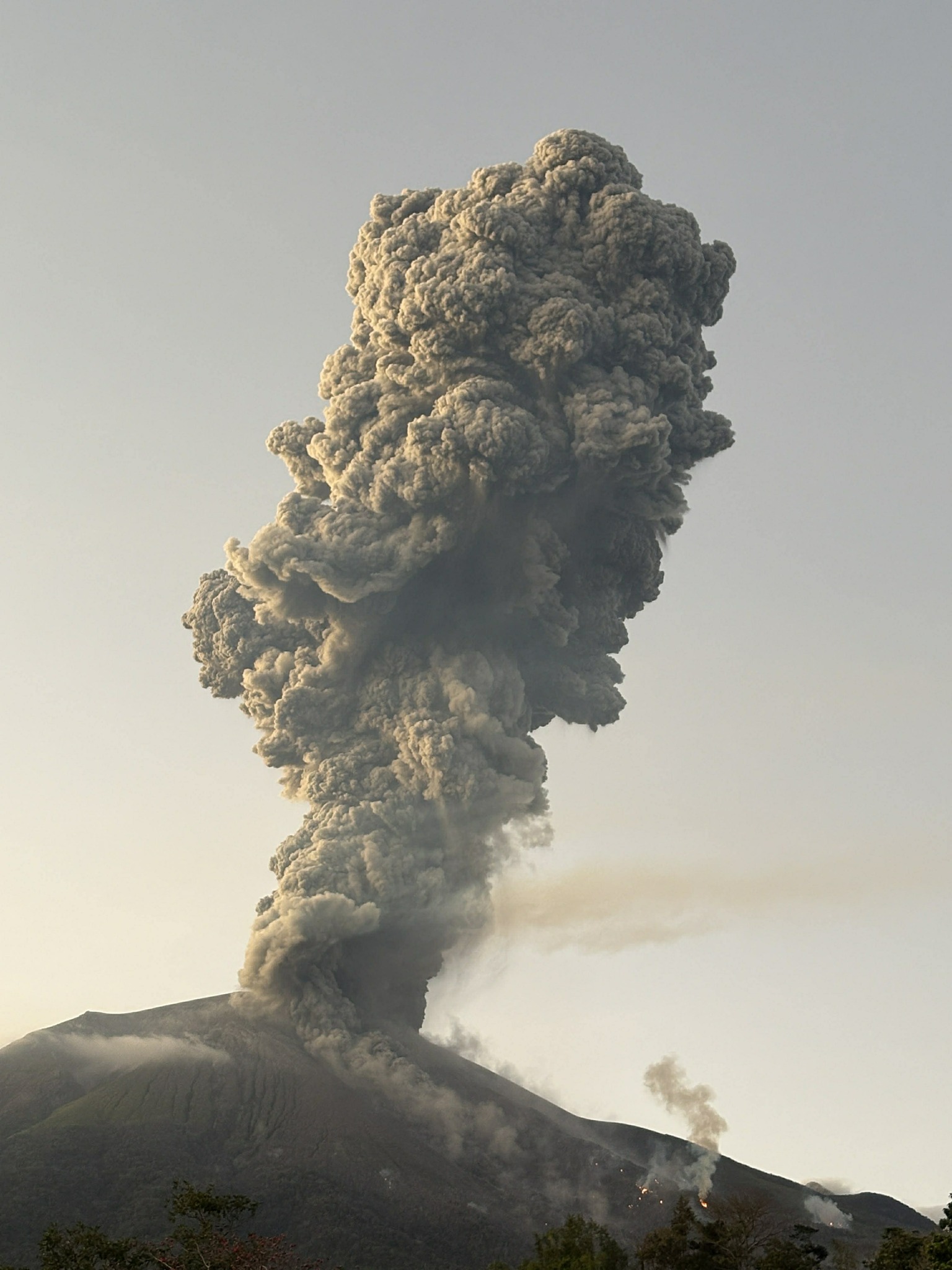
Kanlaon volcano, located on Negros Island, experienced a moderate explosive eruption Sunday evening, its third this year, the Philippine Institute of Seismology and Volcanology (Phivolcs) announced. According to a Phivolcs statement, the eruption occurred at the volcano’s summit at precisely 6:07 p.m.
Alert Level 2 allows for sudden phreatic eruptions and signs of imminent magmatic activity.
Sources : Phivolcs , Inquirer . net / FB.
Photo : Regine Delos Santos Tomaquin / GMA news /FB.
Italy / Sicily , Etna :
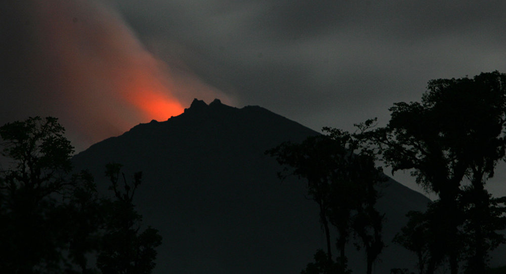
Etna Activity Update, March 15, 2026, 3:32 PM (2:32 PM UTC).
The National Institute of Geophysics and Volcanology, Etna Observatory, reports that thick cloud cover is preventing any visual observation of the ongoing volcanic activity.
From a seismic perspective, the average amplitude of the tremor began to increase steadily at 10:00 AM UTC, reaching its peak at 12:30 PM UTC. Simultaneously, the tremor sources gradually moved closer to the surface, reaching an altitude of 3,000 meters.
Counting and locating infrasound events is difficult due to adverse weather conditions.
Ground deformation monitoring network signals show the beginning of a decompression phase at the DRUV dilatometer, starting around 12:30 UTC. A slight change in trend is also observed at the Cratere del Piano inclinometer.
Further updates will be provided shortly.
Source : INGV.
Photo : Chaudhari NishaBen / l’Etna / FB.
Kamchatka , Sheveluch :
KVERT VOLCANIC ACTIVITY NOTICE (VAN)
Issued: March 16 ,20260316/0451Z
Volcano: Sheveluch (CAVW #300270)
Current aviation colour code: ORANGE
Previous aviation colour code: orange
Source: KVERT
Notice Number: 2026-26
Volcano Location: N 56 deg 38 min E 161 deg 19 min
Area: Kamchatka, Russia
Summit Elevation: 3283 m (10768.24 ft), the dome elevation ~2500 m (8200 ft)
Volcanic Activity Summary:
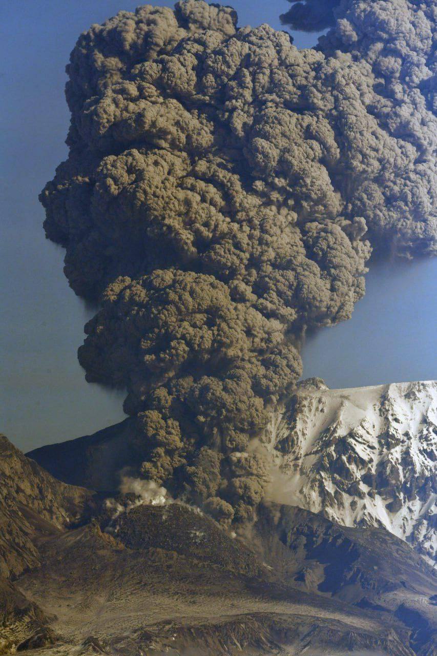
The explosive-extrusive eruption of the volcano continues, accompanied by powerful gas-steam activity; a new block of lava continues to grow in the northern part of the lava dome. Video data shows the explosions sent ash up to 5.5 km a.s.l., and ash plume extends to the northwest of the volcano.
The explosive-extrusive eruption of the volcano continues. Ash explosions up to 12 km (39,400 ft) a.s.l. could occur at any time. Ongoing activity could affect international and low-flying aircraft.
Volcanic cloud height:
5500 m (18040 ft) AMSL Time and method of ash plume/cloud height determination: 20260316/0434Z – Video data
Other volcanic cloud information:
Distance of ash plume/cloud of the volcano: 10 km (6 mi)
Direction of drift of ash plume/cloud of the volcano: NW
Time and method of ash plume/cloud determination: 20260316/0434Z – Video data
Start time of explosion and how determined: 20260316/0430Z – Video data
Source : Kvert .
Photo : Theotherukraine.info / FB.
Ecuador , El Reventador :
REVENTADOR VOLCANO DAILY STATE REPORT, Sunday, March 15, 2026.
Information Geophysical Institute – EPN.
Surface Activity Level: High, Surface Trend: No Change
Internal Activity Level: Moderate, Internal Trend: No Change
From March 14, 2026, 11:00 AM to March 15, 2026, 11:00 AM:
Seismicity:
Explosions (EXP) 44
Long Periods (LP) 4
Emission Tremors (TREMI) 6
Harmonic Tremors (TRARM) 4
Rainfall/Lahars:
Rainfall has been recorded in the volcano area, but it has not generated any mudflows or debris flows. **In the event of heavy rainfall, accumulated material could be remobilized, causing mudflows and debris flows that would cascade down the volcano’s flanks and into nearby rivers.**
Emission Columns/Ash:
Due to data transmission problems, it was not possible to observe gas and ash emissions via the surveillance camera network. However, several gas and ash emissions were detected by satellite imagery, with columns reaching heights of 800 to 1,000 meters above the crater, drifting towards the southeast and east-southeast. In this regard, the Washington VAAC agency published four reports concerning emissions with plumes reaching heights of between 1,000 and 1,300 meters above the crater, drifting south and southeast.
Other monitoring parameters:
Over the past 24 hours, the MIROVA-MODIS and MIROVA-VIIRS satellite systems detected one and two thermal anomalies, respectively. The FIRMS system recorded 11 thermal anomalies.
Note:
According to satellite monitoring, the volcano has remained cloud-covered since yesterday afternoon until the time of this report.
Alert Level – SGR: Orange
Source et photo : IGEPN.