March 11 , 2026.
Hawaii , Kilauea :
HAWAIIAN VOLCANO OBSERVATORY STATUS REPORT , U.S. Geological Survey
Tuesday, March 10, 2026, 12:17 PM HST (Tuesday, March 10, 2026, 22:17 UTC)
19°25’16 » N 155°17’13 » W,
Summit Elevation 4091 ft (1247 m)
Current Volcano Alert Level: WARNING
Current Aviation Color Code: RED

Activity Summary:
Episode 43 of the ongoing Halemaʻumaʻu eruption at Kīlauea summit began around 9:17 a.m. HST on March 10, 2026, and is continuing at this time.
Initial fountains began from the north vent with the south vent starting just before 10 a.m. HST.
Currently the south fountain is 1150 feet (350 meters) high and the north vent is 1000 feet (300 meters) high.
Maximum fountain heights for both vents were over 1300 feet (400 meters).
Lava flows are have covered about one third of the floor of Halemaʻumaʻu crater.
Precursory overflows began from the north vent at 8:20 a.m. HST and continued directly into the fountaining episode.
Tephra fallout, visible in HVO webcams from as early as 9:50 a.m. HST, is creating hazardous conditions in areas downwind, including neighboring communities and Highway 11.
Volcano Village and Mauna Loa Estates – up to 3 inches in diameter
Royal Hawaiian Estates – up half an inch in diameter and Pele’s hair
Fallout that nearly continuously covers the ground has been reported at various overlooks in Hawai’i Volcanoes National Park and Volcano Golf Course.
Hawaii County Civil Defense Agency announced the closure of Highway 11 between the 24 and 40 mile markers due to dangerous conditions being created by tephra falling.
Hawai’i Volcanoes National Park has announced that temporary closures around Kīlauea summit are in place due to volcanic hazards. Lodging guests of Volcano House and Kilauea Military Camp will be allowed to enter the park.
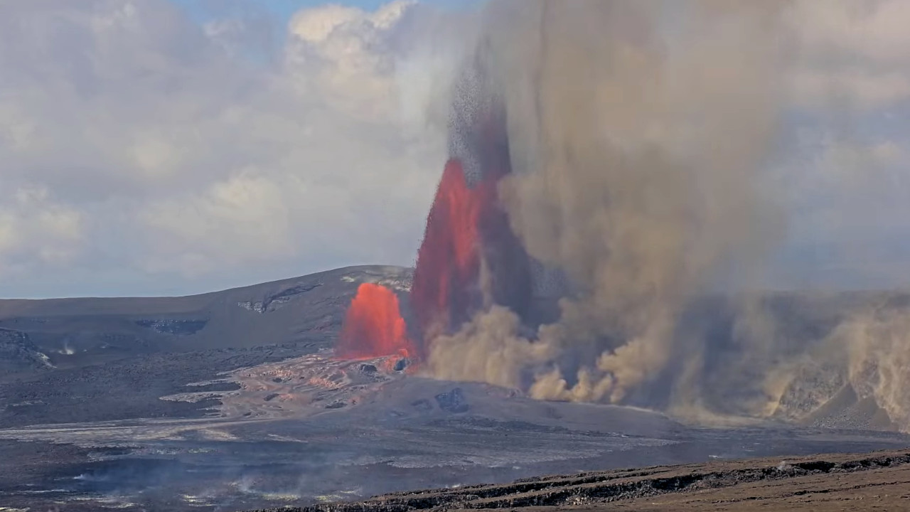
Lava fountains from the south vent are currently reaching 1310 feet, while the north vent lava fountains are a little under 985 feet high.
NWS/VAAC reports the plume currently reaching 30,000 feet above sea level. Winds from the south are currently pushing the plume to the north.
HVO/USGS Volcanic Activity Advisory
Current Volcano Alert Level: WATCH
Current Aviation Color Code: ORANGE
Issued: Tuesday, March 10, 2026, at 6:27 PM HST
Volcanic Activity Summary: Episode 43 of the ongoing Halemaʻumaʻu eruption abruptly ended at 6:21 PM HST on March 10, 2026, after 9 hours of continuous lava fountains. Further information on this eruptive episode will be provided in the next official report.
All eruptive activity was confined to Halemaʻumaʻu Crater, located within Hawaii Volcanoes National Park.
Source : HVO
Photo : Dakota Kinsley , USGS.
La Réunion Island , Piton de la Fournaise :
Press release from the Paris Institute of Earth Physics / Piton de la Fournaise Volcanological Observatory, March 11, 2026 – 9:00 AM local time – 5:00 AM UTC
Eruption in progress
The eruption that began on February 13, 2026, shortly after 10:00 AM (local time) at Piton de la Fournaise continues.
Only one eruptive site remains active on the south-southeast flank of the volcano, visible from Piton de Bert. The eruptive cone is now well-formed and continues to close progressively. Few ejecta now exceed the height of the cone.
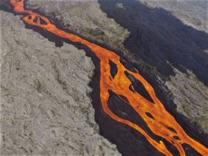
With the lateral closure of the cone, significant lava tube activity is now established. Since March 3, lava flows have been visible again in the upper part of the Grandes Pentes with a new flow arm.
The lava field emitted from the eruptive site forms two main flow arms. The front of the northern arm of the lava flow remains stationary approximately 2.6 km from National Route 2, at an altitude of 660 m.
The front of the southern arm of the lava flow, currently visible from Grand Brulé, was located on March 11 at 5:30 a.m. local time, approximately 1.1 km from National Route 2, at an altitude of about 350 m. Over the past 24 hours, an acceleration in the advance of the lava flow front has been observed, with an advance rate of approximately 35 m per hour (compared to 19 meters per hour previously).
It should be noted that current lava flow models, primarily adapted to the early phases of an eruption, cannot accurately predict if and when the road might be closed. Indeed, the lava is currently flowing mainly through resurgence points in lava tubes, whose rheological properties remain poorly understood, thus limiting the reliability of forecasts. Therefore, given the current speeds of the mudflow front, vigilance is essential to monitor the road closure. From now on, we will track the mudflow’s advance solely through field observations.

As in previous days, seismic activity remains low.
The inflation of the volcano, visible particularly on the summit GNSS stations and at the base of the terminal cone, continues. Since the end of February, the baselines crossing the summit have recorded an increase in distance, indicating a progressive re-expansion of the volcano.
This inflation indicates a repressurization of the magma supply system, possibly linked to magma recharge from the shallow reservoir.
Over the past 24 hours, eruptive tremor (an indicator of lava and gas emissions at the surface) has remained relatively stable. However, in the long term, the amplitude of the tremor shows a progressive increase since February 21. A few amplitude peaks are still being recorded, probably linked to variations in degassing or morphological changes in the eruptive cone.
Surface flow rates, estimated from satellite data via the HOTVOLC platform (OPGC – Clermont Auvergne University), have been less than 7 m³/s over the past 24 hours.
It should be noted that these estimates can vary significantly depending on cloud cover and become zero in the event of total cloud cover. Current lava tube activity also tends to underestimate the flow rates observed by satellite methods.
Alert Level 2.1
Source : OVPF/IPGP.
Photo : Franck Grondin/Frog 974 Photographies/FB
Iceland , Reykjanes Peninsula :
“The seismic activity does not appear to be increasing, and nothing is happening that suggests an eruption is getting closer,” says Benedikt Gunnar Ófeigsson, head of deformation measurements at the Icelandic Meteorological Office, when asked whether a tenth eruption could be expected on the Sundhnúkagígar crater row since the eruption sequence there began in December 2023.
One of the largest magma volumes measured since eruptions began
The pause between eruptions has now become the longest since the eruption series began. Today marks 216 days since the last eruption ended on August 5.
“We continue to observe land uplift, and the magma accumulation has reached the highest levels we have previously seen,” says Ófeigsson. According to model calculations, about 23 million cubic meters of magma have now accumulated beneath Svartsengi since the last eruption, which began July 16 last year.
Land inflation nears one metre as eruption risk remains
He says it is not certain that another eruption will occur, but it would not take much to trigger another event.

“I am somewhat concerned that, whether this becomes the last eruption or not, we may be facing many months of uncertainty. It is difficult to analyze the situation and say whether this sequence of events will end with an eruption or not,” he says.
Last night, a small earthquake swarm occurred just south of Eldey on the Reykjanes Ridge. The largest earthquake measured magnitude 2.7. Ófeigsson says the swarm has since died down.
Source : MBL .is
Photo : mbl. is/Árni Sæberg.
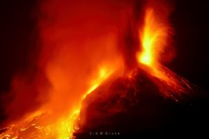
Italy , Stromboli :
WEEKLY BULLETIN, March 2, 2026 to March 8, 2026 (Publication date: March 10, 2026)
ACTIVITY SUMMARY
Based on monitoring data, the following points should be noted:
1) VOLCANOLOGICAL OBSERVATIONS: During this period, ordinary Strombolian-type eruptive activity was observed, interrupted by weak ejections from the North Crater area. The total hourly frequency fluctuated between average (15 events/hour) and high (21 events/hour). The intensity of the explosions was mostly low to medium in the North and Central-South Crater areas.
2) SEISMOLOGY: The monitored seismic parameters showed no significant variation.
3) GROUND DEFORMATION: The signals recorded by the GNSS network showed no significant variation.
The tilt network is not operational.
4) GEOCHEMISTRY: SO2 flux at an average level.
CO2 flux from the ground in the Pizzo area (STR02): increased to very high values, then returned to high values in recent days.
C/S ratio in the pen at average values.
Helium isotope ratio (R/Ra) dissolved in the thermal aquifer: data from the last sample taken on February 26, 2026, indicate high values (R/Ra) = 4.49.
CO2 flux from the ground in the San Bartolo area: at average values, increasing.
CO2 flux STR01 at average values.
5) SATELLITE OBSERVATIONS: Thermal activity observed by satellite in the summit area was generally moderate.

VOLCANOLOGICAL OBSERVATIONS
During the observation period, Stromboli’s eruptive activity was characterized by analyzing images recorded by the INGV-OE monitoring cameras located at 190 m (SCT-SCV) and at Punta dei Corvi (SPCT). Explosive activity was primarily produced by five eruptive vents located in the northern crater area and by at least two vents located in the central-southern area.
Due to cloud cover on March 6, visibility of the crater terrace was insufficient for a precise description of the eruptive activity.
Observations of explosive activity captured by monitoring cameras
In the northern (N) crater area, five active winds were observed: two in sector N1 and three in sector N2.
These vents produced explosive activity ranging from low (less than 80 m high) to medium intensity (less than 150 m high).
In addition, low but continuous ejection activity was observed at the vents in sector N2. The eruptive products were mainly composed of coarse material (bombs and lapilli). The average frequency of explosions ranged from 15 to 18 events per hour.
In the Central-South (CS) crater area, two main winds were observed.
These vents produced explosions of fine material mixed with coarse material, ranging from low to medium intensity. The average frequency of explosions ranged from zero to four events per hour.
Source : INGV.
Photo : Stromboli stati d’animo / Sebastiano Cannavo.
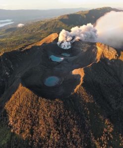
Indonesia , Tambora :
The activity level of Mount Tambora volcano increased from Level I (normal) to Level II (Waspada) on March 10, 2026, at 10:00 AM WITA (Central Indonesian Time).
Mount Tambora, administratively located in the Dompu and Bima districts of West Nusa Tenggara province, has experienced increased volcanic activity. This increase is primarily due to a rise in seismic events related to the upwelling of magma from deep underground into the magma chamber beneath the volcano.
According to seismicity monitoring data, 267 deep volcanic earthquakes were recorded in January 2026. In February 2026, this number increased significantly to 453. This rise indicates an increase in magmatic fluid pressure and magma upwelling from deep underground into the shallow magma system beneath Mount Tambora.

Seismic data from March 1st to 9th, 2026, also indicate that seismic activity remains intense. During this period, 9 avalanche earthquakes, 88 deep volcanic earthquakes, 40 local tectonic earthquakes, and 24 distant tectonic earthquakes were recorded. The predominance of deep volcanic earthquakes suggests that magmatic dynamics beneath the volcano are still ongoing and could potentially lead to increased activity in the near future.
Visually, the volcano’s summit was generally clear or partially obscured by fog, and no crater smoke was observed during the observation period.
Following the evaluation of visual and instrumental data, including seismic data indicating a significant increase in deep volcanic earthquakes, the activity level of Mount Tambora has been raised from Level I (Normal) to Level II (Waspada), effective March 10, 2026, at 10:00 AM Central Indonesia Time (WITA).
Due to this increased activity level, residents near Mount Tambora, as well as visitors and tourists, are advised to stay within a 3-kilometer radius of the volcano’s active center and refrain from any activities there. Furthermore, the public is prohibited from descending to the caldera floor, approaching the parasitic cones Doro Afi Toi and Doro Afi Bou, or the fumaroles located at the caldera floor. The public is also urged to exercise the utmost vigilance regarding the risks of rockfalls or avalanches on the cliffs and walls of the caldera, which can occur at any time due to the instability of the slopes.
Source : PVMBG
Photo : Tom Pfeiffer .