March 1 , 2026.
La Réunion Island , Piton de la Fournaise :
Press release from the Paris Institute of Earth Physics / Piton de la Fournaise Volcanological Observatory, March 1, 2026 – 7:30 a.m. local time – 3:30 a.m. UTC
Eruption in progress
The eruption that began on February 13, 2026, shortly after 10:00 a.m. (local time), at Piton de la Fournaise continues.
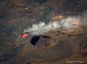
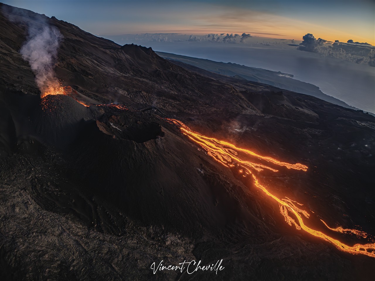
Only one eruptive site remains active on the south-southeast flank of the volcano, with fountains still visible from Piton de Bert. A cone is being built by the progressive accumulation of lava ejecta. This cone is now closed laterally.
With the lateral closure of the cone, significant lava tube activity is now established downstream of the cone. Lava flow resurgences and active aerial parts of the flow are concentrated downstream of the eruptive site and upstream of the Grandes Pentes fault, where the lava field is widening and thickening. The lava flow front remains stationary in the lower part of the Grandes Pentes, approximately 2.6 km from National Route 2 and at an altitude of 660 m.
As in previous days, seismic activity remains low.
The resumption of inflation of the volcano, visible on the summit GNSS stations and at the base of the cone, appears to be confirmed. This development indicates a repressurization of the magma supply system, possibly linked to magma recharge from the shallow reservoir.
The eruptive tremor (an indicator of lava and gas emissions at the surface) remains relatively stable and of low amplitude, with a slight increase over the last 24 hours. Peak amplitudes are still observed, likely linked to variations in degassing or morphological changes in the eruptive cone.
Surface flow rates, estimated from satellite data via the HOTVOLC platforms (OPGC – Université Clermont Auvergne), have indicated values between 1 and 10 m³/sec over the last 24 hours. It should be noted that these estimates can vary rapidly depending on cloud cover and become zero in the event of total cloud cover.
Summary
For the past few days, GNSS network data have suggested a slight inflation of the edifice. This development is linked to a repressurization of the magma supply system, possibly related to a new phase of magma recharge in the shallowest reservoir.
Given the current low seismic activity, the probability of new eruptive fissures opening remains low in the short term.
However, the first signs of possible repressurization could increase this probability.
It should also be noted that in the past, eruptive fissures have opened during an eruption without any warning signs, such as in August 1998, July 1999, October 1999, December 2006, and March 2019. Indeed, the propagation of magma at shallow depths can occur aseismically, particularly when the magma has already degassed.
Alert Level 2.1
Source : OVPF/IPGP.
Photo : Vincent Cheville/Vincent Tunneldelave Réunion/FB.
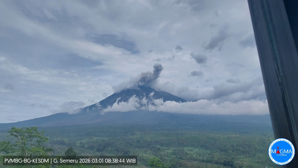
Indonesia , Semeru :
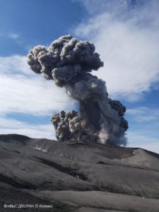
An eruption of Mount Semeru occurred on Sunday, March 1, 2026, at 08:36 WIB, with an observed ash column height of approximately 500 m above the summit (approximately 4176 m above sea level). This ash column, white to gray in color, was highly intense and directed towards the northeast. The eruption was recorded by a seismograph with a maximum amplitude of 22 mm and a duration of 146 seconds.
VOLCANO OBSERVATORY NOTICE FOR AVIATION – VONA
Issued : March 1 , 2026
Volcano : Semeru (263300)
Current Aviation Colour Code : ORANGE
Previous Aviation Colour Code : orange
Source : Semeru Volcano Observatory
Notice Number : 2026SMR416
Volcano Location : S 08 deg 06 min 29 sec E 112 deg 55 min 12 sec
Area : East java, Indonesia
Summit Elevation : 11763 FT (3676 M)
Volcanic Activity Summary :
Eruption with volcanic ash cloud at 01h36 UTC (08h36 local).
Volcanic Cloud Height :
Best estimate of ash-cloud top is around 13363 FT (4176 M) above sea level or 1600 FT (500 M) above summit. May be higher than what can be observed clearly. Source of height data: ground observer.
Other Volcanic Cloud Information :
Ash cloud moving to northeast. Volcanic ash is observed to be white to gray. The intensity of volcanic ash is observed to be thick.
Remarks :
Eruption recorded on seismogram with maximum amplitude 22 mm and maximum duration 146 second.
Source et photo : Magma Indonésie.
Chile , Planchón-Peteroa :
During the evaluated period, volcano-tectonic (VT) seismic activity, associated with rock fracturing within the volcano, showed a decrease in the number of recorded events, while energy release levels remained stable compared to the previous period.
The most energetic recorded VT event had a local magnitude (ML) of 1.6 and was located 2.5 km north-northeast (NNE) of the volcanic edifice, at a depth of 4.3 km from the active crater.
Seismic activity associated with fluid movement within the volcano, represented by long-period (LP) earthquakes and tremors (TR), also showed a decrease in the number of recorded events, while energy release levels remained stable compared to the previous period. The maximum energy released during LP events, recorded by reduced displacement (DR), was 11 cm². For TR events, the maximum value recorded per reduced displacement (DR) was 9 cm². Furthermore, the continuous tremor signal energy, recorded from the RSAM value and associated with sustained fluid dynamics within the volcano, continues to show a downward trend, although the values remain significantly above their baseline levels. Future changes cannot be ruled out.

Over the course of two weeks, low-lying, whitish degassing columns were repeatedly recorded at the summit of the volcano. The highest column recorded on February 9 was 260 m above the crater rim. Notably, no nighttime incandescence or pyroclastic material (volcanic ash) was recorded during this period.
For the period under review, satellite data processing detected no sulfur dioxide (SO₂) anomalies in the atmosphere near the volcanic edifice.
During the analyzed period, five (5) low-magnitude thermal anomalies were detected by VIIRS350, with a maximum radiative power (PRV) of 0.18 MW on February 15.
Geodetic monitoring conducted during this period revealed no significant variations related to volcanic activity. Morphological analysis, based on PlanetScope and Sentinel-2 L2A satellite imagery, showed that the emission of gas and water vapor from the Southwest Crater continues. Furthermore, no emissions or deposition of pyroclastic material were recorded during these two weeks.
Source et photo : Segemar
Colombia , Puracé – Los Coconucos volcanic chain :
Popayán, February 24, 2026, 3:00 PM
Regarding the monitoring of activity at the Puracé volcano and the Los Coconucos volcanic chain, the Colombian Geological Survey (SGC), an agency under the Ministry of Mines and Energy, reports the following:
During the week of February 17-23, 2026, a predominance of earthquakes associated with fluid movements within the volcanic edifice, of the Long Period (LP) and Tremor (TR) type, persisted. These earthquakes, located below the crater of the Puracé volcano, at a depth of less than 1 km, were linked to circulation processes and the release of volcanic gases into the atmosphere. These gases dispersed with the wind, reaching a maximum altitude of 2,000 m above the summit of the volcano.
Compared to previous weeks, fracture seismicity has remained stable, both in terms of the number of events and the seismic energy released. It is primarily located between the Puracé and Piocollo volcanoes, at depths of 1 to 3 km. Sulfur dioxide (SO₂) emissions continue to be observed, and gases continue to escape from fissures in the craters of the Curiquinga and Piocollo volcanoes, although no associated ash emissions have been identified to date. Satellite observations indicate that the energy of the thermal anomaly in the Puracé volcano crater remains constant. Furthermore, the slow deformation process persists between the Puracé, Piocollo, and Curiquinga volcanoes, detected after the eruptive episode of Curiquinga on January 20, 2025.
In conclusion, the variations observed in the Puracé-Los Coconucos volcanic chain indicate that the system continues to evolve and that ash emissions and fallout could continue, depending on the prevailing wind direction. The public is advised to refrain from ascending to the upper part of the volcanic chain and to remain attentive to official bulletins from the Colombian Geological Survey (SGC).
The alert level for volcanic activity remains yellow: active volcano showing changes in monitored parameters and other manifestations.
Source et photo : SGC.
Italy , Campi Flegrei :
Campi Flegrei – Update Statement #3
Since 10:18 UTC on February 28, 2026, there has been an earthquake swarm in the Campi Flegrei area.
At the time of this statement, 25 earthquakes with a magnitude of Md ± 0.0 and a maximum magnitude of Md = 3.5 ± 0.3 have been recorded.
Weekly Bulletin, February 16-22, 2026. (Publication date: February 24, 2026)
ACTIVITY SUMMARY:
Based on monitoring data, the following points should be noted:
1) SEISMOLOGY: From February 16 to 22, 2026, 34 earthquakes of magnitude Md ≥ 0.0 (Mdmax = 2.8 ± 0.3) were recorded in the Phlegraean Fields region.
2) DEFORMATION: Since the beginning of February 2026, a decrease in the ground uplift velocity has been recorded, with a preliminary monthly average velocity of approximately 10 ± 5 mm/month.
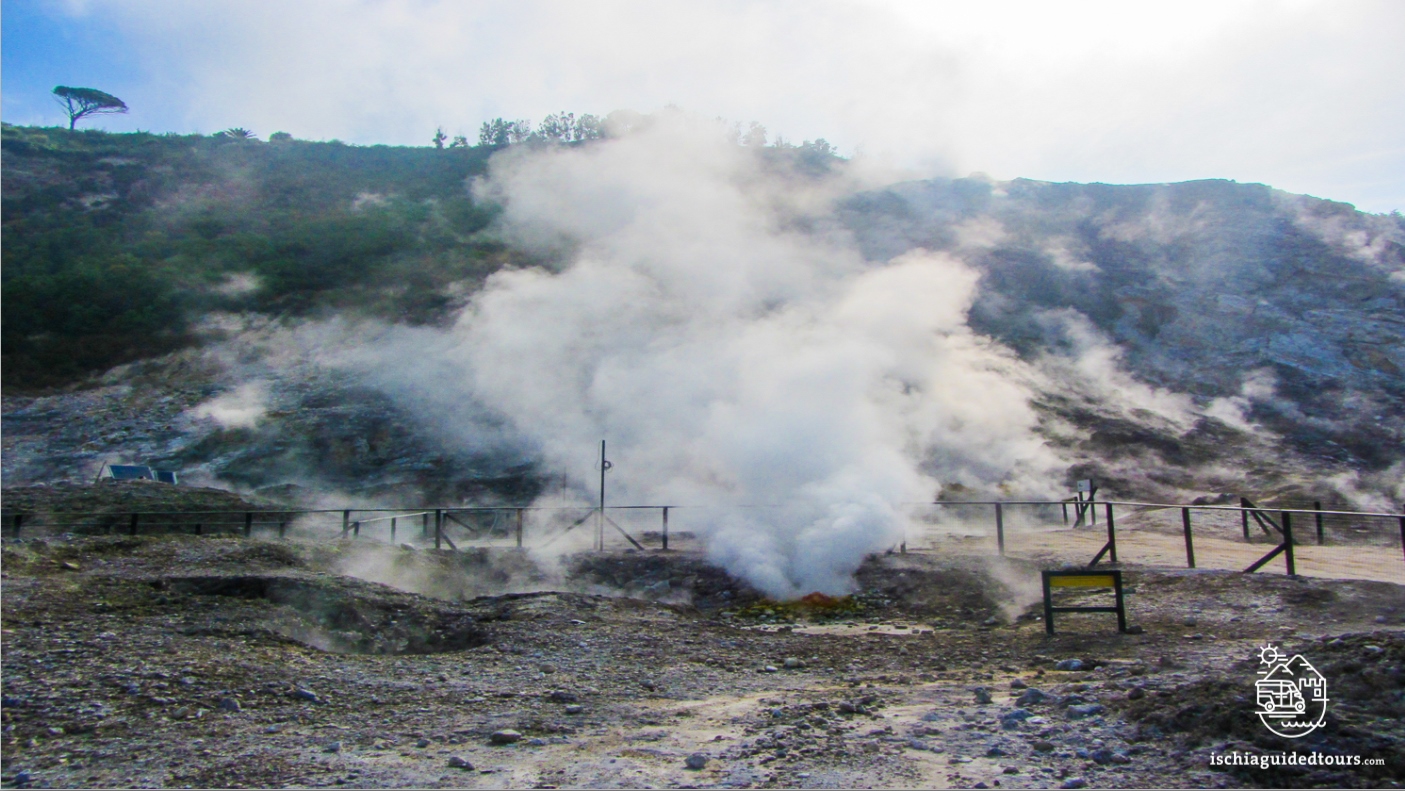
3) GEOCHEMISTRY: During the reference week, the monitored geochemical parameters confirm the long-term warming trend of the hydrothermal system and the increase in flow rates already observed (see Monthly Bulletins). The temperature of fumarole BG, in the Solfatara crater, has shown an upward trend in recent months; the average value for the reference period is approximately 173 °C.
GROUND DEFORMATION
Since mid-December 2025, a decrease in the ground uplift rate has been recorded, with an average monthly rate of approximately 15 ± 3 mm/month. Since the beginning of February 2026, a further decrease in the ground uplift rate has been recorded, with a preliminary average monthly rate of approximately 10 ± 5 mm/month.
The total uplift recorded at the GNSS RITE station is approximately 24.5 cm since January 2025.