January 31 , 2026.
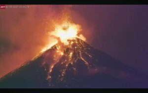
Alaska , Shishaldin :
Signs of volcanic unrest at Shishaldin Volcano continued this week. Low-level seismic activity with frequent small earthquakes and volcanic tremor was detected all week. Infrasound signals, likely caused by gas bubbles bursting deep within the volcanic vent, were also detected throughout the week when the conditions were not too windy. A steam and gas plume was observed in satellite and webcam views when the weather was clear. Satellite imagery from January 28 and 29 showed that this plume contains sulfur dioxide from the degassing of shallow magma.

Satellite imagery showed barely elevated surface temperatures within the summit crater when the weather was clear, likely related to the warm gas plume and heating of the vent area by shallow magma. At this time, there is no evidence of lava at the surface.
Shishaldin Volcano is monitored by local seismic and infrasound sensors, web cameras, and a telemetered geodetic network. In addition to the local monitoring network, the Alaska Volcano Observatory uses nearby geophysical networks, regional infrasound and lighting data, and satellite data to monitor the volcano.
Source : AVO.
Photo : Loewen, Matt.
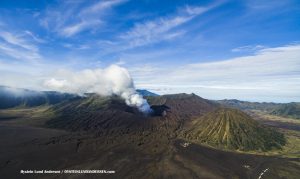
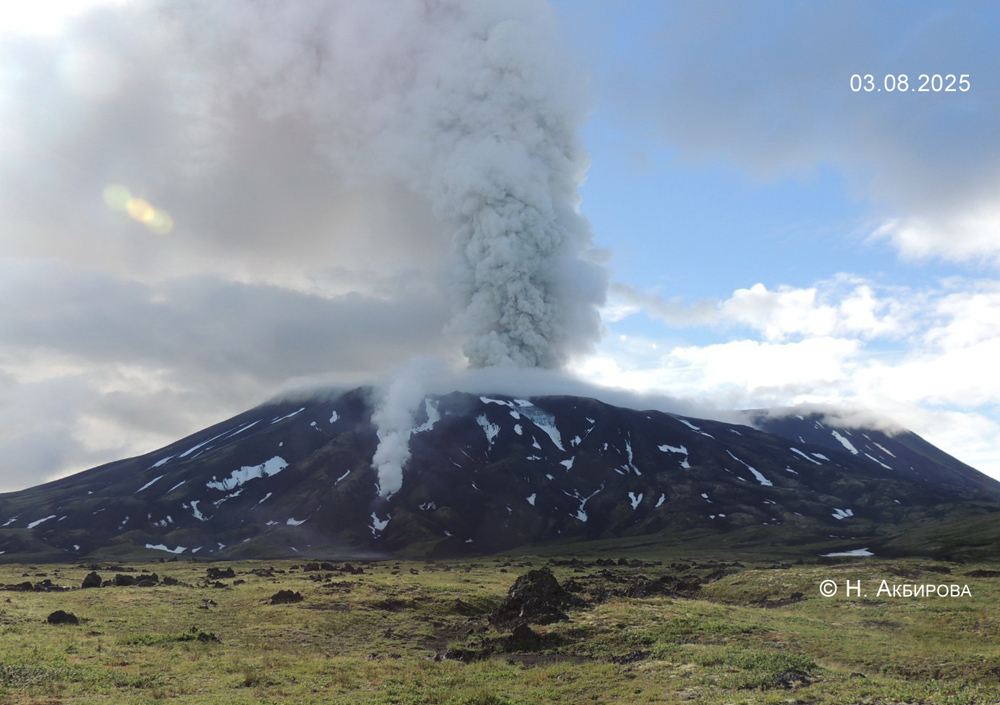
Kamchatka , Krasheninnikov :
KVERT VOLCANIC ACTIVITY NOTICE (VAN)
Issued: January 29 , 2026
Volcano: Krasheninnikov (CAVW #300190)
Current aviation colour code: YELLOW
Previous aviation colour code: orange
Source: KVERT
Notice Number: 2026-10
Volcano Location: N 54 deg 36 min E 160 deg 16 min
Area: Kamchatka, Russia
Summit Elevation: 1856 m (6087.68 ft)
Volcanic Activity Summary:
The effusive eruption of the volcano continues: lava flows are effusing to the eastern slopes of the Northern Cone of the volcano, and a gas-steam emission from this Cone is observing. Satellite data by KVERT showed a large bright thermal anomaly on the volcano all week, but the Value of Temperature Difference between the thermal Anomaly and the Background (the VTDAB) began to decrease from 18 January, 2026.
The effusive eruption of the volcano continues. The danger of ash explosions up to 6 km (19,700 ft) a.s.l. remains. Ongoing activity could affect low-flying aircraft.
Volcanic cloud height: NO ASH CLOUD PRODUSED
Other volcanic cloud information: NO ASH CLOUD PRODUSED
Remarks:
The first historical eruption of the volcano began on 02 August, 2025. The explosive-effusive eruption of the volcano continues. The previous effusive eruption of the volcano occurred 400-600 years ago.
Source : Kvert.
Photo : N. Akbirova , 3/8/2025.
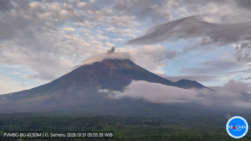
Indonesia , Semeru :
Mount Semeru experienced an eruption on Saturday, January 31, 2026 at 5:55 AM WIB. An ash column was observed approximately 700 meters above the summit (at an altitude of about 4,376 meters). This column, white to gray in color and of moderate intensity, was drifting northward. At the time of writing, the eruption was still ongoing.
VOLCANO OBSERVATORY NOTICE FOR AVIATION – VONA
Issued : January 30 , 2026
Volcano : Semeru (263300)
Current Aviation Colour Code : ORANGE
Previous Aviation Colour Code : orange
Source : Semeru Volcano Observatory
Notice Number : 2026SMR217
Volcano Location : S 08 deg 06 min 29 sec E 112 deg 55 min 12 sec
Area : East java, Indonesia
Summit Elevation : 11763 FT (3676 M)
Volcanic Activity Summary :
Eruption with volcanic ash cloud at 22h55 UTC (05h55 local).
Volcanic Cloud Height :
Best estimate of ash-cloud top is around 14003 FT (4376 M) above sea level or 2240 FT (700 M) above summit. May be higher than what can be observed clearly. Source of height data: ground observer.
Other Volcanic Cloud Information :
Ash cloud moving to north. Volcanic ash is observed to be white to gray. The intensity of volcanic ash is observed to be medium.
Remarks :
Eruption recorded on seismogram with maximum amplitude 22 mm and maximum duration 115 second.
Source et photo : PVMBG.
Colombia , Puracé – Los Coconucos volcanic chain :
Popayán, January 27, 2026, 3:30 PM
Regarding the monitoring of activity at the Puracé volcano, the Colombian Geological Survey (SGC), an agency under the Ministry of Mines and Energy, reports the following:
During the week of January 20-26, 2026, earthquakes associated with fluid movements within the volcanic edifice continued to occur. These were long-period (LP) earthquakes, including tremor pulses (TR). These earthquakes were located below the crater of the Puracé volcano, at depths of less than 1 km, and were related to circulation processes and the release of volcanic gases into the atmosphere. Some of these signals were associated with ash emissions that dispersed southwestward, following the wind direction, reaching an altitude of 1,850 m above the summit of the volcano.
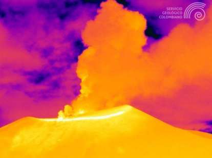
Recording from the Mina camera, located 2.2 km north of the Puracé volcano, showing the ash emission of January 26, 2026, at 8:15 PM (local time).
Compared to observations from previous weeks, fracture seismicity remained stable, both in number and seismic energy released, with events occurring mainly between the Puracé, Piocollo, and Curiquinga volcanoes, at depths between 1 and 3 km.
Sulfur dioxide (SO₂) emissions continue to be recorded, and gases continue to escape from fissures in the craters of the Curiquinga and Piocollo volcanoes, although no associated ash emission has been identified to date. Satellite observations indicate a decrease in the intensity of the thermal anomaly in the Puracé volcano crater. Furthermore, a slow deformation process persists between the Puracé, Piocollo, and Curiquinga volcanoes, as evidenced by the eruption of Curiquinga on January 20, 2025.
In addition, seismic recordings and webcam images detected a secondary mudflow (lahar) at 2:45 p.m. on January 24, associated with heavy rainfall and the remobilization of ash deposited in recent weeks in the upper reaches of the Puracé, Piocollo, and Curiquinga volcanoes, along the Cocuy River basin, toward the northeastern flank of the volcanic chain. Events of this type could recur during periods of heavy rainfall in the highlands, due to the recent ash accumulation.
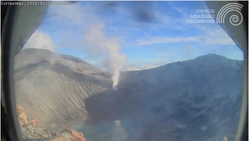
Image taken by the camera inside the crater of the Curiquinga volcano, showing degassing through the fissure on its north wall. Image dated January 26, 2026.
In conclusion, the variations observed at the Puracé volcano – part of the Los Coconucos volcanic chain – indicate that the system continues to evolve and that ash emissions and fallout could continue, depending on the prevailing wind direction. The public is advised not to travel to the upper part of the volcanic chain and to remain attentive to official bulletins from the Geological Survey of Colombia (SGC).
The alert level for volcanic activity remains yellow: active volcano exhibiting changes in the baseline behavior of monitored parameters and other manifestations.
Source et photos : SGC.
La Martinique Island , Mount Pelée :
Paris Institute of Earth Physics / Martinique Volcanological and Seismological Observatory. Saint-Pierre, January 30, 2026, 2:30 p.m. local time (GMT-4)
Volcanic activity remained low this week with 8 volcanic earthquakes observed.
Between January 23, 2026, at 4:00 p.m. UTC and January 30, 2026, at 4:00 p.m. UTC, the Martinique Volcanological and Seismological Observatory recorded:
• 8 shallow, low-energy volcano-tectonic earthquakes. These earthquakes originated from the well-known seismically active zones of Mount Pelée, located between 1.0 and 1.4 km below the volcano’s summit. Shallow volcano-tectonic seismicity is associated with microfracturing in the volcanic edifice, linked to the overall reactivation of the volcano observed since 2019.
No earthquakes have been felt by the population.
The previous week, the OVSM (Mountain Seismological Observatory) recorded 6 volcanic earthquakes. As of January 30, 2026, and over the past four weeks, the OVSM has observed a total of 253 volcanic earthquakes, an average of 63 to 64 earthquakes per week.
During phases of volcanic reactivation of volcanoes similar to Mount Pelée, seismic activity of varying intensity and frequency is common. The probability of an eruptive activity in the short term remains low. However, considering all the observations collected since the end of 2018 and their nature, and based on recent observations from the OVSM-IPGP (Paris Institute of Earth Physics), we cannot rule out a change in the situation in the medium term (weeks, months).
For more details on observations and interpretations of volcanic activity over the longer term, please refer to the OVSM’s monthly bulletins. The volcanic alert level, in accordance with the provisions made by the authorities, is currently YELLOW: vigilance.
Source : Direction de l’OVSM-IPGP.
Photo : OVSM IPGP