January 28 , 2026.
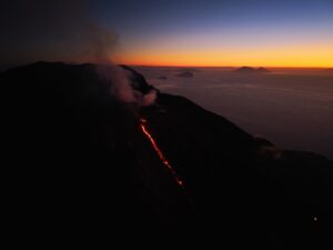
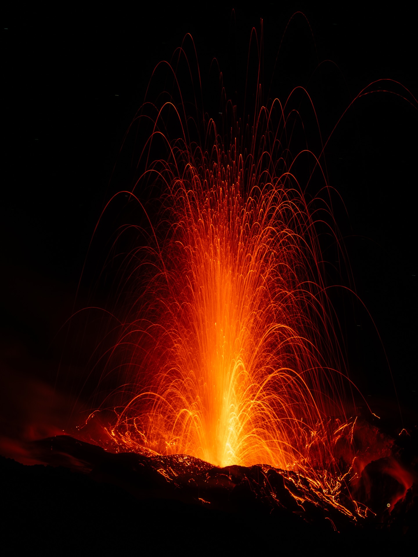
Italy , Stromboli :
WEEKLY BULLETIN, January 19, 2026 to January 25, 2026. (Publication date: January 27, 2026)
ACTIVITY SUMMARY
Based on monitoring data, the following points should be noted:
1) VOLCANOLOGICAL OBSERVATIONS: During this period, ordinary Strombolian-type eruptive activity was observed. The total hourly frequency fluctuated between average values (9 events/h) and high values (21 events/h). The intensity of the explosions was mainly low to medium in the North and Central-South crater areas.
2) SEISMOLOGY: The monitored seismic parameters showed no significant variation.
3) GROUND DEFORMATION: The ground deformation monitoring networks did not show significant variations. The tilt measurement network is still affected by disturbances that compromise its reliability.
4) GEOCCHEMISTRY: Average SO₂ flux.
Very high CO₂ flux from the ground in the Pizzo area (STR02).
Average C/S ratio in the pen.
Dissolved helium isotope ratio (R/Ra) in the thermal aquifer: no update. Last data: 12/12/2025 (high value: 4.44).
CO₂ flux from the ground in the San Bartolo area: average to high values.
CO₂ flux from the ground in the Scari area: almost stable at approximately 170 g/m²/day.
5) SATELLITE OBSERVATIONS: Satellite-observed thermal activity in the summit area was generally low, with a few isolated thermal anomalies of moderate intensity.
VOLCANOLOGICAL OBSERVATIONS
During the observation period, Stromboli’s eruptive activity was characterized by analyzing images recorded by the INGV-OE monitoring cameras located at 190 m (SCT-SCV) and at Punta dei Corvi (SPCT). Explosive activity was primarily produced by five eruptive vents located in the northern zone of the crater and by at least two vents located in the central-southern zone.
Due to heavy cloud cover on January 19 and 25, the crater terrace was not visible for a sufficient number of hours to accurately describe the eruptive activity.
Observations of explosive activity captured by the monitoring cameras:
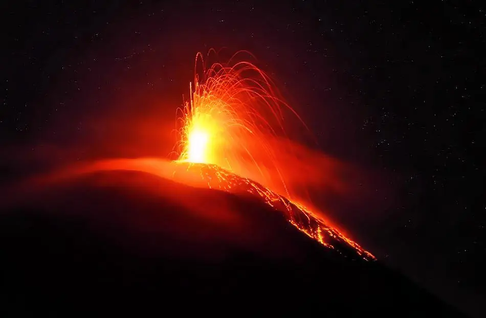
In the northern (N) zone of the crater, five active vents were observed, two in sector N1 and three in sector N2. These vents produced explosive activity of low intensity (less than 80 m high) and medium intensity (less than 150 m high). The eruptive products were primarily coarse materials (bombs and lapilli).
The average frequency of explosions ranged from 4 to 18 events per hour.
In the Central-South (CS) crater area, two main vents were observed, exhibiting explosions of fine and coarse materials of low to medium intensity.
The average frequency of explosions ranged from 3 to 6 events per hour.
Source : INGV
Photo : Stromboli stati d’animo / Sebastiano Cannavo.
Italy / Sicily , Etna :
WEEKLY BULLETIN, January 19, 2026 to January 25, 2026. (Publication date: January 27, 2026)
ACTIVITY SUMMARY
Based on monitoring data, the following points should be noted:
1) VOLCANOLOGICAL OBSERVATIONS: Variable rate of degassing from summit craters.
2) SEISMOLOGY: Low seismic activity due to fracturing. Low to medium tremor amplitude.
3) INFRASOUND: Moderate infrasound activity.
4) GROUND DEFORMATION: During the week, ground deformation monitoring networks showed no significant variation.
5) GEOCHEMISTRY: Average SO₂ flux.
The CO₂ flux from the ground (EtnaGas network) is low.
Partial pressure of dissolved CO₂ in groundwater (EtnaWater network): no update.
Helium isotope ratio at peripheral stations: average values, decreasing (latest data from December 22).
6) SATELLITE OBSERVATIONS: Over the past week, thermal activity observed by satellite in the summit area has generally been low.

VOLCANOLOGICAL OBSERVATIONS
During the week in question, monitoring of Mount Etna’s volcanic activity was carried out through the analysis of images from the INGV – Osservatorio Etneo (INGV-OE) surveillance cameras and satellite imagery.
Observations from the surveillance cameras were severely limited throughout the period due to adverse weather conditions, which also prevented direct field observations.
On the rare occasions when the summit craters were clear of clouds, such as early in the morning of January 23, intense degassing activity of varying intensity was observed.
Source : INGV
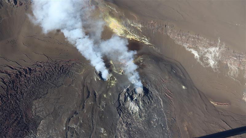
Photo : Giovinsky Aetnensis
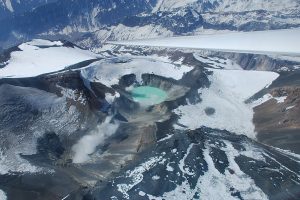
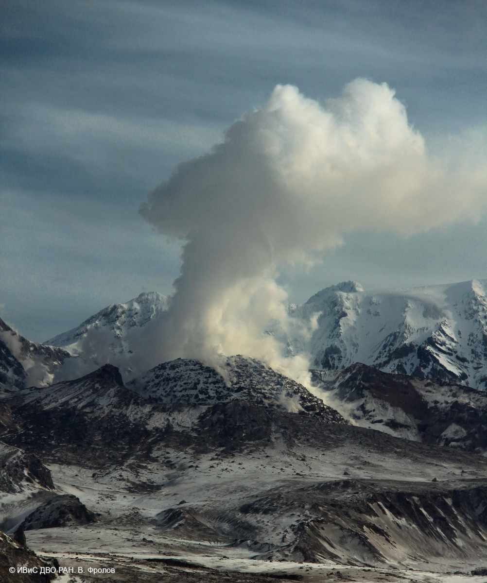
Kamchatka , Sheveluch :
KVERT VOLCANIC ACTIVITY NOTICE (VAN)
Issued: January 28 , 2026
Volcano: Sheveluch (CAVW #300270)
Current aviation colour code: ORANGE
Previous aviation colour code: orange
Source: KVERT
Notice Number: 2026-08
Volcano Location: N 56 deg 38 min E 161 deg 19 min
Area: Kamchatka, Russia
Summit Elevation: 3283 m (10768.24 ft), the dome elevation ~2500 m (8200 ft)
Volcanic Activity Summary:
A growth of the lava dome of the Young Sheveluch volcano continues, this process is accompanied by powerful gas-steam emissions. Satellite data by KVERT showed an explosion sent ash up to 8 km a.s.l., and ash plume extended for 15 km to the west of the volcano.
An explosive-extrusive eruption of the volcano continues. A danger of ash explosions up to 12 km (39,400 ft) a.s.l. remains. Ongoing activity could affect international and low-flying aircraft.
Volcanic cloud height:
7500-8000 m (24600-26240 ft) AMSL Time and method of ash plume/cloud height determination: 20260128/0454Z – Video data
Other volcanic cloud information:
Distance of ash plume/cloud of the volcano: 15 km (9 mi)
Direction of drift of ash plume/cloud of the volcano: W
Time and method of ash plume/cloud determination: 20260128/0454Z – Video data
Start time of explosion and how determined: 20260128/0454Z – Video data
Duration of explosion: ~ 15 min
Source : Kvert.
Photo : V. Frolov. IVS FEB RAS.
Indonesia , Ili Lewotolok :
An eruption of Mount Ili Lewotolok occurred on Tuesday, January 27, 2026, at 8:53 PM WITA. The observed ash column rose approximately 200 meters above the summit (at an altitude of about 1,623 meters). This gray ash column, of moderate to thick intensity, was moving eastward. The eruption was recorded by a seismograph with a maximum amplitude of 14.3 mm and a duration of 40 seconds.
Seismic Observations
30 eruption earthquakes with amplitudes between 7 and 17.8 mm and durations of 43 to 162 seconds.
110 emission earthquakes with amplitudes between 2.7 and 15.2 mm and durations of 28 seconds.
1 non-harmonic tremor with an amplitude of 7 mm and a duration of 162 seconds.
Recommendations
1. Residents living around Mount Ili Lewotolok, as well as visitors, climbers, and tourists, are advised to refrain from entering a 3 km radius around the center of activity on Mount Ili Lewotolok and from conducting any activities there.
2. Be vigilant for the risk of lava avalanches and pyroclastic flows in the south, southeast, west, and northeast sectors of Mount Ili Lewotolok.
Source et photo : PVMBG.
Hawaii , Kilauea :
HAWAIIAN VOLCANO OBSERVATORY DAILY UPDATE , U.S. Geological Survey
Tuesday, January 27, 2026, 9:21 AM HST (Tuesday, January 27, 2026, 19:21 UTC)
19°25’16 » N 155°17’13 » W,
Summit Elevation 4091 ft (1247 m)
Current Volcano Alert Level: WATCH
Current Aviation Color Code: ORANGE
Activity Summary:
The Halemaʻumaʻu eruption of Kīlauea paused on January 24 at 7:29 p.m. HST at the end of episode 41 fountaining. Based on preliminary data, the current forecast for the onset of episode 42 lava fountaining is between February 10 to 20, 2026. No significant activity has been noted along Kīlauea’s East Rift Zone or Southwest Rift Zone.
Summit Observations:
Consistent glow was visible on webcams within the south vent overnight, while glow from the north vent was intermittent. Seismic tremor continued in the past 24 hours with 2-3 pulses of increased tremor every ten minutes, with weak micro seismic swarm activity at times. No earthquakes were located beneath Kīlaueaʻs summit in the last 24 hours. Overnight webcam views show a few points of incandescence as lava flows from episode 41 continue to cool on the floor of Halemaʻumaʻu crater. Sporadic creeping and incandescence may continue for another day or two.
This photograph shows the current vent area at the summit of Kīlauea, with passive outgassing plumes originating from the south (left) and north (right) vents. The plumes are carried to the southwest by the tradewinds. On the left side of the photo, the cracked area shows a region of the crater floor where thick deposits of spatter from an earlier lava fountaining episode began to flow downhill, forming a spatter-fed lava flow.
The UWD tiltmeter recorded 8.0 microradians of inflation since the end of episode 41, including an increase of 2.3 microradians in the past 24 hours.
A magnitude 4.2 earthquake near Pāhala at 11:37 pm last night caused a -0.25 microradian measurement offset at summit tiltmeter at Sand Hill (SDH); this is a response of the instrument itself and does not indicate any changes at the Kīlauea summit region following the earthquake. The same earthquake produced transient spikes in the data at other summit area tiltmeters (including UWD).
The sulfur dioxide (SO2) emission rate from the summit was last measured on January 14 at 1,550 tonnes per day, which is within the typical range of 1,000 to 5,000 tonnes of SO2 per day observed during previous eruptive pauses. This is considerably lower than rates observed during lava fountaining episodes.
Rift Zone Observations:
Rates of seismicity and ground deformation remain very low in the East Rift Zone and Southwest Rift Zone. SO2 emissions from the East Rift Zone remain below the detection limit.
Source : HVO.
Photo : USGS / T. Orr